Scientia Agricultura Sinica ›› 2024, Vol. 57 ›› Issue (2): 250-263.doi: 10.3864/j.issn.0578-1752.2024.02.003

• TILLAGE & CULTIVATION·PHYSIOLOGY & BIOCHEMISTRY·AGRICULTURE INFORMATION TECHNOLOGY • Previous Articles     Next Articles

Exploring the Impacts of Temporal Composition Window for Integrating Multi-Source Decametric-Resolution Images on Crop Type Identification

TONG WanTing1(), WEI HaoDong2, YANG JingYa3, JIN WenJie1, SONG Qian3(), HU Qiong4, YIN GaoFei5, XU BaoDong1()   

  1. 1 College of Resources and Environment/Macro Agriculture Research Institute, Huazhong Agricultural University, Wuhan 430070
    2 College of Plant Science and Technology, Huazhong Agricultural University, Wuhan 430070
    3 Institute of Agricultural Resources and Regional Planning, Chinese Academy of Agricultural Sciences/State Key Laboratory of Efficient Utilization of Arid and Semi-Arid Arable Land in Northern China, Beijing 100081
    4 School of Urban and Environmental Sciences, Central China Normal University, Wuhan 430079
    5 Faculty of Geosciences and Environmental Engineering, Southwest Jiaotong University, Chengdu 610031
  • Received:2023-05-25 Accepted:2023-08-17 Online:2024-01-16 Published:2024-01-19
  • Contact: SONG Qian, XU BaoDong

Abstract:

【Background】 The decametric-resolution (≤30 m) image is an important data source to identify crop types in South China dominated by fragmented croplands and complex cropping patterns. Due to the relative long revisit frequency of decametric-resolution sensors and persistent rainy/cloud weather in South China, it is critical to integrate multi-source decametric-resolution images using the temporal composition method for the generation of spatiotemporal continuous crop type map. Due to the different temporal resolutions of different satellites, and the significant differences in phenological quaternal rhythms of various crop types, selecting the optimal temporal composition window for integrating multi-source images is vital to map crop type distribution accurately.【Objective】 This study aims to explore the impact of image temporal composition windows on crop type identification, and to provide significant references for large-scale crop type mapping in regions with complex terrain.【Method】 In this study, Landat-8 and Sentinel-2 data were integrated to extract the crop type distribution in the Jianghan Plain, Hubei Province, characterized by the various crop types and cloudy and rainy weather. Then, seven scenarios (15, 20, 25, 30, 40, 50, and 60 d) were established to analyze the effect of different temporal composition windows on crop type identification. Specifically, three aspects, including image coverage rate, spectral-temporal feature curves for different crops and classification accuracies, were combined to understand the performances of different scenarios comprehensively.【Result】 The crop type mapping using 20-day composition window performed the best, with the overall accuracy (OA) of 93.13%. In contrast, the scenarios that used narrower temporal composition window derived lower accuracy of crop type identification (e.g., OA=90.91% for the 15-day composition window), which can be primarily attributed to the low coverage rate of good observations in the study area. Meanwhile, since time series images composited in the wide window blurred the key phenological information for different crops, the classification accuracy of crop type mapping scenarios using wide temporal interval was also lower (e.g., OA=86.06% for the 60-day composition window). Additionally, the effect of temporal interval on different crops classification was ranked as following: other crops>rapeseed>rice>wheat>rice-crayfish. In detail, the reason why the classification performance of other crops was the most sensitive to the temporal composition window can be due to the high intra-class phenological variance of this type. Flowering period is the key phenology window to identify rapeseed, therefore, the classification accuracy of rapeseed decreased while the temporal composition window exceeds 30-day, and rapeseed was easily confused with wheat. Furthermore, because the key phenology window to distinguish rice-crayfish from single-cropping rice (i.e., the flooding stage of rice-crayfish fields) lasted a long period (e.g., from October 2020 to June 2021), the classification accuracy of rice-crayfish was less sensitive to the temporal composition window.【Conclusion】 In general, the 20-day impact of the temporal composition window can take into account the high-quality image coverage and capture of key phenological characteristics of crop identification, but the optimal temporal composition window of different crops identification is affected by the key phenological period of crops. This study provides theoretical reference and method support for selecting the optimal temporal composition window to generate multi-source image time series, which is promising to improve the efficiency and accuracy of large-scale crop type mapping.

Key words: crop type mapping, temporal composition window, random forest, Sentinel-2, Landsat-8

Fig. 1

The crop calendar in Jianghan Plain"

Fig. 2

Pixel-level counts of high-quality Landsat-8 and Sentinel-2 images"

Table 1

The vegetation indices used in this study and their equations"

植被指数
Vegetation index
公式
Equation
参考文献
Reference
归一化植被指数
NDVI
$N D V I=\frac{\rho_{N I R}-\rho_{R E D}}{\rho_{N I R}+\rho_{R E D}}$ [40]
陆表水分指数
LSWI
$L S W I=\frac{\rho_{\text {NIR }}-\rho_{\text {SWIR } 1}}{\rho_{\text {NIR }}+\rho_{\text {SWIR } 1}}$ [47]
增强型植被指数
EVI
$E V I=\frac{2.5 \times\left(\rho_{\text {SWIR1 }}-\rho_{\text {RED }}\right)}{\rho_{\text {NIR }}+6 \times \rho_{\text {RED }}-7.5 \times \rho_{\text {BLUE }}+1}$ [45]
绿度指数
VIgreen
$\text { VIgreen }=\frac{\rho_{\text {GREEN }}-\rho_{\text {RED }}}{\rho_{\text {GREEN }}+\rho_{\text {RED }}}$ [46]

Fig. 3

Averaged number of good observations and the percentage of pixels which had at least one good observation within different temporal composition windows"

Fig. 4

The temporal trajectory of NDVI and LSWI time series within different temporal composition windows"

Fig. 5

Crop classification results for typical regions within different temporal composition windows and the Sentinel-2 image in March 2021 in pseudocolor composition"

Fig. 6

The accuracy of derived crop type identification within different temporal composition windows"

Fig. 7

Changes in crop classification accuracy within different temporal composition windows"

[1]
胡琼, 吴文斌, 宋茜, 余强毅, 杨鹏, 唐华俊. 农作物种植结构遥感提取研究进展. 中国农业科学, 2015, 48(10): 1900-1914. doi: 10.3864/j.issn.0578-1752.2015.10.004.
HU Q, WU W B, SONG Q, YU Q Y, YANG P, TANG H J. Recent progresses in research of crop patterns mapping by using remote sensing. Scientia Agricultura Sinica, 2015, 48(10): 1900-1914. doi: 10.3864/j.issn.0578-1752.2015.10.004. (in Chinese)
[2]
LUO C, QI B S, LIU H J, GUO D, LU L P, FU Q, SHAO Y Q. Using time series Sentinel-1 images for object-oriented crop classification in Google earth engine. Remote Sensing, 2021, 13(4): 561.

doi: 10.3390/rs13040561
[3]
ZHANG W T, WANG M, GUO J, LOU S T. Crop classification using MSCDN classifier and sparse auto-encoders with non-negativity constraints for multi-temporal, Quad-Pol SAR data. Remote Sensing, 2021, 13(14): 2749.

doi: 10.3390/rs13142749
[4]
GELLA G W, BIJKER W, BELGIU M. Mapping crop types in complex farming areas using SAR imagery with dynamic time warping. ISPRS Journal of Photogrammetry and Remote Sensing, 2021, 175: 171-183.

doi: 10.1016/j.isprsjprs.2021.03.004
[5]
KANG Y, HU X, MENG Q, ZOU Y F, ZHANG L L, LIU M, ZHAO M F. Land cover and crop classification based on red edge indices features of GF-6 WFV time series data. Remote Sensing, 2021, 13(22): 4522.

doi: 10.3390/rs13224522
[6]
WANG N, ZHAI Y, ZHANG L. Automatic cotton mapping using time series of Sentinel-2 images. Remote Sensing, 2021, 13(7): 1355.

doi: 10.3390/rs13071355
[7]
GUO Y, XIA H M, ZHAO X Y, QIAO L X, QIN Y C. Estimate the earliest phenophase for garlic mapping using time series Landsat 8/9 images. Remote Sensing, 2022, 14(18): 4476.

doi: 10.3390/rs14184476
[8]
CLAUSS K, YAN H, KUENZER C. Mapping paddy rice in China in 2002, 2005, 2010 and 2014 with MODIS time series. Remote Sensing, 2016, 8(5): 434.

doi: 10.3390/rs8050434
[9]
张馨予, 蔡志文, 杨靖雅, 王聪, 魏浩东, 胡琼, 徐保东. 时序滤波对农作物遥感识别的影响. 农业工程学报, 2022, 38(4): 215-224.
ZHANG X Y, CAI Z W, YANG J Y, WANG C, WEI H D, HU Q, XU B D. Impacts of temporal smoothing methods on crop type identification. Transactions of the Chinese Society of Agricultural Engineering, 2022, 38(4): 215-224. (in Chinese)
[10]
何真, 胡洁, 蔡志文, 王文静, 胡琼. 协同多时相国产GF-1和GF-6卫星影像的艾草遥感识别. 农业工程学报, 2022, 38(1): 186-195.
HE Z, HU J, CAI Z W, WANG W J, HU Q. Remote sensing identification for Artemisia argyi integrating multi-temporal GF-1 and GF-6 images. Transactions of the Chinese Society of Agricultural Engineering, 2022, 38(1): 186-195. (in Chinese)
[11]
杨靖雅, 胡琼, 魏浩东, 蔡志文, 张馨予, 宋茜, 徐保东. 基于Sentinel-1/2数据的中国南方单双季稻识别结果一致性分析. 中国农业科学, 2022, 55(16): 3093-3109. doi: 10.3864/j.issn.0578-1752.2022.16.003.
YANG J Y, HU Q, WEI H D, CAI Z W, ZHANG X Y, SONG Q, XU B D. Consistency analysis of classification results for single and double cropping rice in Southern China based on Sentinel-1/2imagery. Scientia Agricultura Sinica, 2022, 55(16): 3093-3109. doi: 10.3864/j.issn.0578-1752.2022.16.003. (in Chinese)
[12]
QU C, LI P, ZHANG C. A spectral index for winter wheat mapping using multi-temporal Landsat NDVI data of key growth stages. ISPRS Journal of Photogrammetry and Remote Sensing, 2021, 175: 431-447.

doi: 10.1016/j.isprsjprs.2021.03.015
[13]
XIAO W, XU S, HE T. Mapping paddy rice with Sentinel-1/2 and phenology-, object-based algorithm—A implementation in Hangjiahu Plain in China using GEE platform. Remote Sensing, 2021, 13(5): 990.

doi: 10.3390/rs13050990
[14]
THENKABAIL P S, WU Z. An automated cropland classification algorithm (ACCA) for Tajikistan by combining Landsat, MODIS, and secondary data. Remote Sensing, 2012, 4(10): 2890-2918.

doi: 10.3390/rs4102890
[15]
WANG J, XIAO X M, LIU L, WU X C, QIN Y W, STEINER J L, DONG J W. Mapping sugarcane plantation dynamics in Guangxi, China, by time series Sentinel-1, Sentinel-2 and Landsat images. Remote Sensing of Environment, 2020, 247: 111951.

doi: 10.1016/j.rse.2020.111951
[16]
LI Q, WANG C, ZHANG B, LU L. Object-based crop classification with Landsat-MODIS enhanced time-series data. Remote Sensing, 2015, 7(12): 16091-16107.

doi: 10.3390/rs71215820
[17]
ZHANG H, LIU W, ZHANG L. Seamless and automated rapeseed mapping for large cloudy regions using time-series optical satellite imagery. ISPRS Journal of Photogrammetry and Remote Sensing, 2022, 184: 45-62.

doi: 10.1016/j.isprsjprs.2021.12.001
[18]
宋茜, 周清波, 吴文斌, 胡琼, 余强毅, 唐华俊. 农作物遥感识别中的多源数据融合研究进展. 中国农业科学, 2015, 48(6): 1122-1135. doi: 10.3864/j.issn.0578-1752.2015.06.09.
SONG Q, ZHOU Q B, WU W B, HU Q, YU Q Y, TANG H J. Recent progresses in research of integrating multi-source remote sensing data for crop mapping. Scientia Agricultura Sinica, 2015, 48(6): 1122-1135. doi: 10.3864/j.issn.0578-1752.2015.06.09. (in Chinese)
[19]
LIU L, XIAO X, QIN Y, WANG J, XU X, HU Y, QIAO Z. Mapping cropping intensity in China using time series Landsat and Sentinel-2 images and Google earth engine. Remote Sensing of Environment, 2020, 239: 111624.

doi: 10.1016/j.rse.2019.111624
[20]
PAN L, XIA H, ZHAO X, GUO Y, QIN Y. Mapping winter crops using a phenology algorithm, time-series Sentinel-2 and Landsat-7/8 images, and Google earth engine. Remote Sensing, 2021, 13(13): 2510.

doi: 10.3390/rs13132510
[21]
LI Q, LIU G, CHEN W. Toward a simple and generic approach for identifying multi-year cotton cropping patterns using Landsat and Sentinel-2 time series. Remote Sensing, 2021, 13(24): 5183.

doi: 10.3390/rs13245183
[22]
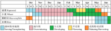
魏浩东, 杨靖雅, 蔡志文, 陈云坪, 张馨予, 徐保东, 胡琼. 物候窗口和多源中高分辨率影像的稻虾田提取. 遥感学报, 2022, 26(7): 1423-1436.
WEI H D, YANG J Y, CAI Z W, CHEN Y P, ZHANG X Y, XU B D, HU Q. Phenology windows and multi-source medium-/high-resolution image extraction for rice-crayfish paddy fields mapping. National Remote Sensing Bulletin, 2022, 26(7): 1423-1436. (in Chinese)

doi: 10.11834/jrs.20211070
[23]
TIAN H F, HUANG N, NIU Z, QIN Y C, PEI J, WANG J. Mapping winter crops in China with multi-source satellite imagery and phenology-based algorithm. Remote Sensing, 2019, 11(7): 820.

doi: 10.3390/rs11070820
[24]
YOU N, DONG J. Examining earliest identifiable timing of crops using all available Sentinel 1/2 imagery and Google earth engine. ISPRS Journal of Photogrammetry and Remote Sensing, 2020, 161: 109-123.

doi: 10.1016/j.isprsjprs.2020.01.001
[25]
HUANG X D, HUANG J X, LI X C, SHEN Q R, CHEN Z C. Early mapping of winter wheat in Henan Province of China using time series of Sentinel-2 data. GIScience & Remote Sensing, 2022, 59(1): 1534-1549.
[26]
XU F, LI Z F, ZHANG S Y, HUANG N T, QUAN Z Y, ZHANG W M, LIU X J, JIANG X S, PAN J J, PRISHCHEPOV A V. Mapping winter wheat with combinations of temporally aggregated Sentinel-2 and Landsat-8 data in Shandong Province, China. Remote Sensing, 2020, 12(12): 2065.

doi: 10.3390/rs12122065
[27]
周惠慧, 王楠, 黄瑶, 王晋年, 张立福. 不同时间间隔下的遥感时间序列重构模型比较分析. 地球信息科学学报, 2016, 18(10): 1410-1417.

doi: 10.3724/SP.J.1047.2016.01410
ZHOU H H, WANG N, HUANG Y, WANG J N, ZHANG L F. Comparison and analysis of remotely sensed time series of reconstruction models at various intervals. Journal of Geo-Information Science, 2016, 18(10): 1410-1417. (in Chinese)
[28]
张紫荆, 华丽, 郑萱, 李嘉麟. 基于GEE平台与Sentinel-NDVI时序数据江汉平原种植模式提取. 农业工程学报, 2022, 38(1): 196-202.
ZHANG Z J, HUA L, ZHENG X, LI J L. Extraction of cropping patterns in Jianghan Plain based on GEE and Sentinel-NDVI time series data. Transactions of the Chinese Society of Agricultural Engineering, 2022, 38(1): 196-202. (in Chinese)
[29]
FILIPPUCCI P, BROCCA L, BONAFONI S, SALTALIPPI C, WAGNER W, TARPANELLI A. Sentinel-2 high-resolution data for river discharge monitoring. Remote Sensing of Environment, 2022, 281: 113255.

doi: 10.1016/j.rse.2022.113255
[30]
DONG J W, XIAO X M, MENARGUEZ M A, ZHANG G L, QIN Y W, THAU D, BIRADAR C, MOORE B. Mapping paddy rice planting area in northeastern Asia with Landsat 8 images, phenology-based algorithm and Google earth engine. Remote Sensing of Environment, 2016, 185: 142-154.

doi: 10.1016/j.rse.2016.02.016 pmid: 28025586
[31]
SCARAMUZZA P L, BOUCHARD M A, DWYER J L. Development of the Landsat data continuity mission cloud-cover assessment algorithms. IEEE Transactions on Geoscience and Remote Sensing, 2012, 50(4): 1140-1154.

doi: 10.1109/TGRS.2011.2164087
[32]
ROY D P, KOVALSKYY V, ZHANG H K, VERMOTE E F, YAN L, KUMAR S S, EGOROV A. Characterization of Landsat-7 to Landsat-8 reflective wavelength and normalized difference vegetation index continuity. Remote Sensing of Environment, 2016, 185(1): 57-70.

doi: 10.1016/j.rse.2015.12.024
[33]
ZHANG H K, ROY D P, YAN L, LI Z B, HUANG H Y, VERMOTE E, SKAKUN S, ROGER J C. Characterization of Sentinel-2A and Landsat-8 top of atmosphere, surface, and nadir BRDF adjusted reflectance and NDVI differences. Remote Sensing of Environment, 2018, 215: 482-494.

doi: 10.1016/j.rse.2018.04.031
[34]
CHEN J, CHEN J, LIAO A P, CAO X, CHEN L J, CHEN X H, HE C Y, HAN G, PENG S, LU M, ZHANG W W, TONG X H, MILLS J. Global land cover mapping at 30 m resolution: A POK-based operational approach. ISPRS Journal of Photogrammetry and Remote Sensing, 2015, 103: 7-27.

doi: 10.1016/j.isprsjprs.2014.09.002
[35]
XU L, ZHANG H, WANG C, WEI S, ZHANG B, WU F, TANG Y. Paddy rice mapping in Thailand using time-series Sentinel-1 data and deep learning model. Remote Sensing, 2021, 13(19): 3994.

doi: 10.3390/rs13193994
[36]
HU J, CHEN Y, CAI Z, WEI H, ZHANG X, ZHOU W, WANG C, YOU L, XU B. Mapping diverse paddy rice cropping patterns in South China using harmonized Landsat and Sentinel-2 data. Remote Sensing, 2023, 15(4): 1034.

doi: 10.3390/rs15041034
[37]
LU M, WU W, ZHANG L, LIAO A, PENG S, TANG H. A comparative analysis of five global cropland datasets in China. Science China Earth Sciences, 2016, 59: 2307-2317.

doi: 10.1007/s11430-016-5327-3
[38]
CHEN J, CAO X, PENG S, REN H. Analysis and applications of GlobeLand30: A review. ISPRS International Journal of Geo- Information, 2017, 6: 230.

doi: 10.3390/ijgi6080230
[39]
CAO B, YU L, NAIPAL V, CIAIS P, LI W, ZHAO Y Y, WEI W, CHEN D, LIU Z, GONG P. A 30 m terrace mapping in China using Landsat 8 imagery and digital elevation model based on the Google earth engine. Earth System Science Data, 2021, 13(5): 2437-2456.

doi: 10.5194/essd-13-2437-2021
[40]
JIANG Z, HUETE A R, CHEN J, CHEN Y, LI J, YAN G, ZHANG X. Analysis of NDVI and scaled difference vegetation index retrievals of vegetation fraction. Remote Sensing of Environment, 2006, 101: 366-378.

doi: 10.1016/j.rse.2006.01.003
[41]
ARVOR D, JONATHAN M, MEIRELLES M S P, DUBREUIL V, DURIEUX L. Classification of MODIS EVI time series for crop mapping in the state of Mato Grosso, Brazil. International Journal of Remote Sensing, 2011, 32: 7847-7871.

doi: 10.1080/01431161.2010.531783
[42]
EASTMAN J, SANGERMANO F, MACHADO E, ROGAN J, ANYAMBA A. Global trends in seasonality of normalized difference vegetation index (NDVI), 1982-2011. Remote Sensing, 2013, 5: 4799-4818.

doi: 10.3390/rs5104799
[43]
WEI H, HU Q, CAI Z, YANG J, SONG Q, YIN G, XU B D. An object- and topology-based analysis (OTBA) method for mapping rice-crayfish fields in South China. Remote Sensing, 2021, 13(22): 4666.

doi: 10.3390/rs13224666
[44]
KUNKEL V R, WELLS T, HANCOCK G R. Modelling soil organic carbon using vegetation indices across large catchments in eastern Australia. Science of the Total Environment, 2022, 817: 152690.

doi: 10.1016/j.scitotenv.2021.152690
[45]
HUETE A, DIDAN K, MIURA T, RODRIGUEZ E P, GAO X, FERREIRA L G. Overview of the radiometric and biophysical performance of the MODIS vegetation indices. Remote Sensing of Environment, 2002, 83: 195-213.

doi: 10.1016/S0034-4257(02)00096-2
[46]
PEÑA-BARRAGÁN J, NGUGI M, PLANT R, SIX J. Object-based crop identification using multiple vegetation indices, textural features and crop phenology. Remote Sensing of Environment, 2011, 115(6): 1301-1316.

doi: 10.1016/j.rse.2011.01.009
[47]
GAO B C. NDWI—A normalized difference water index for remote sensing of vegetation liquid water from space. Remote Sensing of Environment, 1996, 58: 257-266.

doi: 10.1016/S0034-4257(96)00067-3
[48]
霍轩琳, 牛振国, 张波, 刘林崧, 李霞. 高寒湿地分类的遥感特征优选研究. 遥感学报, 2023, 27(4): 1045-1060.
HUO X L, NIU Z G, ZHANG B, LIU L S, LI X. Remote sensing feature selection for alpine wetland classification. National Remote Sensing Bulletin, 2023, 27(4): 1045-1060. (in Chinese)

doi: 10.11834/jrs.20222080
[49]
XIAO X, BOLES S, FROLKING S, LI C, BABU J Y, SALAS W, MOORE B. Mapping paddy rice agriculture in South and Southeast Asia using multi-temporal MODIS images. Remote Sensing of Environment, 2006, 100: 95-113.

doi: 10.1016/j.rse.2005.10.004
[50]
HE Y L, DONG J W, LIAO X Y, SUN L, WANG Z P, YOU N S, LI Z C, FU P. Examining rice distribution and cropping intensity in a mixed single- and double-cropping region in South China using all available Sentinel 1/2 images. International Journal of Applied Earth Observation and Geoinformation, 2021, 101: 102351.

doi: 10.1016/j.jag.2021.102351
[51]
ZHANG X, WU B F, PONCE-CAMPOS G, ZHANG M, CHANG S, TIAN F Y. Mapping up-to-date paddy rice extent at 10 m resolution in China through the integration of optical and synthetic aperture radar images. Remote Sensing, 2018, 10(8): 1200.

doi: 10.3390/rs10081200
[52]
YOU N S, DONG J W, HUANG J X, DU G M, ZHANG G L, HE Y L, YANG T, DI Y Y, XIAO X M. The 10-m crop type maps in Northeast China during 2017-2019. Scientific Data, 2021, 8(1): 41.

doi: 10.1038/s41597-021-00827-9 pmid: 33531510
[53]
LUCIANO A C, PICOLI M C A, ROCHA J V, DUFT D G, LAMPARELLI R A C, LEAL M R L V, LE MAIRE G. A generalized space-time OBIA classification scheme to map sugarcane areas at regional scale, using Landsat images time-series and the random forest algorithm. International Journal of Applied Earth Observation and Geoinformation, 2019, 80: 127-136.

doi: 10.1016/j.jag.2019.04.013
[54]
CAI Z, HU Q, ZHANG X, YANG J, WEI H, HE Z, SONG Q, WANG C, YIN G, XU B. An adaptive image segmentation method with automatic selection of optimal scale for extracting cropland parcels in smallholder farming systems. Remote Sensing, 2022, 14(13): 3067.

doi: 10.3390/rs14133067
[55]
RODRIGUEZ-GALIANO V F, GHIMIRE B, ROGAN J, CHICA- OLMO M, RIGOL-SANCHEZ J P. An assessment of the effectiveness of a random forest classifier for land-cover classification. ISPRS Journal of Photogrammetry and Remote Sensing, 2012, 67: 93-104.

doi: 10.1016/j.isprsjprs.2011.11.002
[56]
LIU W B, ZHANG H Y. Mapping annual 10 m rapeseed extent using multisource data in the Yangtze River Economic Belt of China (2017-2021) on Google earth engine. International Journal of Applied Earth Observation and Geoinformation, 2023, 117: 103198.

doi: 10.1016/j.jag.2023.103198
[1] WANG JiaYue, CAI ZhiWen, WANG WenJing, WEI HaoDong, WANG Cong, LI ZeXuan, LI XiuNi, HU Qiong. Integrating Multi-Source Gaofen Images and Object-Based Methods for Crop Type Identification in South China [J]. Scientia Agricultura Sinica, 2023, 56(13): 2474-2490.
[2] WANG ShuTing, KONG YuGuang, ZHANG Zan, CHEN HongYan, LIU Peng. SPAD Value Inversion of Cotton Leaves Based on Satellite-UAV Spectral Fusion [J]. Scientia Agricultura Sinica, 2022, 55(24): 4823-4839.
[3] WU Jun,GUO DaQian,LI Guo,GUO Xi,ZHONG Liang,ZHU Qing,GUO JiaXin,YE YingCong. Prediction of Soil Organic Carbon Content in Jiangxi Province by Vis-NIR Spectroscopy Based on the CARS-BPNN Model [J]. Scientia Agricultura Sinica, 2022, 55(19): 3738-3750.
[4] GUO Can,YUE XiaoFeng,BAI YiZhen,ZHANG LiangXiao,ZHANG Qi,LI PeiWu. Research on the Application of a Balanced Sampling-Random Forest Early Warning Model for Aflatoxin Risk in Peanut [J]. Scientia Agricultura Sinica, 2022, 55(17): 3426-3436.
[5] SHEN Zhe,ZHANG RenLian,LONG HuaiYu,XU AiGuo. Research on Spatial Distribution of Soil Texture in Southern Ningxia Based on Machine Learning [J]. Scientia Agricultura Sinica, 2022, 55(15): 2961-2972.
[6] ZHOU Ke, LIU Le, ZHANG YanNa, MIAO Ru, YANG Yang. Area Extraction and Growth Monitoring of Winter Wheat in Henan Province Supported by Google Earth Engine [J]. Scientia Agricultura Sinica, 2021, 54(11): 2302-2318.
[7] ZHANG ZhenHua,DING JianLi,WANG JingZhe,GE XiangYu,WANG JinJie,TIAN MeiLing,ZHAO QiDong. Digital Soil Properties Mapping by Ensembling Soil-Environment Relationship and Machine Learning in Arid Regions [J]. Scientia Agricultura Sinica, 2020, 53(3): 563-573.
[8] XI Xue,ZHAO GengXing,GAO Peng,CUI Kun,LI Tao. Inversion of Soil Salinity in Coastal Winter Wheat Growing Area Based on Sentinel Satellite and Unmanned Aerial Vehicle Multi-Spectrum— A Case Study in Kenli District of the Yellow River Delta [J]. Scientia Agricultura Sinica, 2020, 53(24): 5005-5016.
[9] XIA ShuFeng,WANG Fan,WANG LongJun,ZHOU Qin,CAI Jian,WANG Xiao,HUANG Mei,DAI TingBo,JIANG Dong. Study on the Adaptability of Wheat Reaching the Protein Content Standard of Soft Wheat in Jiangsu Province [J]. Scientia Agricultura Sinica, 2020, 53(24): 4992-5004.
[10] SHEN Zhe,ZHANG RenLian,LONG HuaiYu,WANG Zhuan,ZHU GuoLong,SHI QianXiong,YU KeFan,XU AiGuo. Research on Spatial Distribution of Soil Particle Size Distribution in Loess Region Based on Three Spatial Prediction Methods—Taking Haiyuan County in Ningxia as an Example [J]. Scientia Agricultura Sinica, 2020, 53(18): 3716-3728.
[11] ZHANG ChunLan, YANG GuiJun, LI HeLi, TANG FuQuan, LIU Chang, ZHANG LiYan. Remote Sensing Inversion of Leaf Area Index of Winter Wheat Based on Random Forest Algorithm [J]. Scientia Agricultura Sinica, 2018, 51(5): 855-867.
[12] WANG Fei,YANG ShengTian,WEI Yang,YANG XiaoDong,DING JianLi. Influence of Sub-Region Priority Modeling Constructed by Random Forest and Stochastic Gradient Treeboost on the Accuracy of Soil Salinity Prediction in Oasis Scale [J]. Scientia Agricultura Sinica, 2018, 51(24): 4659-4676.
[13] HE Ying, DENG Lei, MAO ZhiHui, SUN Jie. Remote Sensing Estimation of Canopy SPAD Value for Maize Based on Digital Camera [J]. Scientia Agricultura Sinica, 2018, 51(15): 2886-2897.
[14] LIU Ya-qiu, CHEN Hong-yan, WANG Rui-yan, CHANG Chun-yan, CHEN Zhe. Quantitative Analysis of Soil Salt and Its Main Ions Based on Visible/Near Infrared Spectroscopy in Estuary Area of Yellow River [J]. Scientia Agricultura Sinica, 2016, 49(10): 1925-1935.
Viewed
Full text


Abstract

Cited

  Shared   
  Discussed   
No Suggested Reading articles found!