


中国农业科学 ›› 2025, Vol. 58 ›› Issue (19): 3857-3871.doi: 10.3864/j.issn.0578-1752.2025.19.005
邵明超( ), 安敬威, 刘博睿, 吴建双, 张琪, 姚霞, 程涛, 江冲亚, 曹卫星, 郑恒彪(), 朱艳()
收稿日期:2025-03-25
接受日期:2025-07-23
出版日期:2025-10-01
发布日期:2025-10-10
通信作者:
联系方式:
邵明超,E-mail:2021201106@stu.njau.edu.cn。
基金资助:
SHAO MingChao(), AN JingWei, LIU BoRui, WU JianShuang, ZHANG Qi, YAO Xia, CHENG Tao, JIANG ChongYa, CAO WeiXing, ZHENG HengBiao(), ZHU Yan()
Received:2025-03-25
Accepted:2025-07-23
Published:2025-10-01
Online:2025-10-10
摘要:
【目的】小麦苗情等级反映苗期生长状态和健康水平,是产量预测与田间管理的重要依据。传统依赖人工经验的苗情评估方法在大田应用中存在效率低、主观性强和难以推广的局限。本研究基于无人机搭载RGB传感器,结合地面实测农艺参数,探索融合多模态遥感特征的小麦苗情综合评估方法,为大尺度和跨区域监测提供技术路径。【方法】在江苏省通过设计多站点和多高度航测试验以采集无人机影像,并同步采集分蘖数、冠层覆盖度等农艺参数。基于植被指数和纹理特征提取作物光谱与结构信息,利用信息值(IV)与基尼系数(GINI)实现特征筛选,构建随机森林(RF)、极端梯度提升(XGBoost)和梯度提升决策树(GBDT)等多种机器学习模型,评估苗情等级的分类精度,并基于局部方差系数确定最优图像分辨率以提升应用的稳定性和跨区域适应性。【结果】增强型绿红差异指数(EXGR)对苗期冠层覆盖度的识别精度最优(像素精度(PA)=0.69,特异性(S)=0.83)。绿红比值指数(GRRI)与分蘖数呈现显著相关关系(R2=0.58,相对均方根误差(rRMSE)=0.28)。融合农艺参数与遥感特征的随机森林算法在苗情等级划分方法精度最高(PA=0.85,R=0.86),其中分蘖数和纹理信息(E_energy)对苗情等级划分贡献最大(IV>0.70),(35±5) m的飞行高度是获得高质量无人机数据的重要参考(local variance=0.17)。【结论】通过构建融合农艺参数与遥感特征的小麦苗情综合评估框架,证明便携式无人机RGB影像结合机器学习方法在跨区域苗情等级监测中的可行性和高效性。本方法可为区域尺度的苗情动态评估、种植管理策略制定及粮食安全保障提供数据支持与方法参考。
邵明超, 安敬威, 刘博睿, 吴建双, 张琪, 姚霞, 程涛, 江冲亚, 曹卫星, 郑恒彪, 朱艳. 基于多模态数据的小麦苗情综合评估研究[J]. 中国农业科学, 2025, 58(19): 3857-3871.
SHAO MingChao, AN JingWei, LIU BoRui, WU JianShuang, ZHANG Qi, YAO Xia, CHENG Tao, JIANG ChongYa, CAO WeiXing, ZHENG HengBiao, ZHU Yan. Comprehensive Assessment of Wheat Seedling Growth Status Based on Multimodal Data[J]. Scientia Agricultura Sinica, 2025, 58(19): 3857-3871.
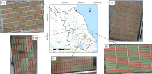
图1
研究区概况 (a):徐州 Xuzhou;(b):兴化 Xinghua;(c):如皋 Rugao;(d):连云港 Lianyungang;(e):大丰 Dafeng"

表1
本研究使用的植被指数"
| 植被指数 Vegetation index | 公式 Formula |
|---|---|
| 绿红比指数 Green-red ration index (GRRI) | G/R |
| 绿蓝比指数 Green-blue ration index (GBRI) | G/B |
| 蓝红比指数 Blue-red ration index (BRRI) | B/R |
| 过红指数 Excess red (EXR) | 1.4×R-G |
| 过绿指数 Excess green (EXG) | 2×G-R-B |
| 过绿-过红指数 Excess green minus excess red (EXGR) | EXG-EXR |
| 植被颜色指数 Color index of vegetation (CIVE) | 0.441×r-0.881×g+0.385×b+18.7874 |
| 修正超绿指数 Modified excess green (MEXG) | 1.262×g-0.884×r-0.311×b |
| 红绿蓝植被指数 Red green blue vegetation Index (RGBVI) | (G×G-B×R)/(G×G+B×R) |
| 归一化红绿差异指数Normalized green-red difference index (NGBDI) | (G-B)/(G+B) |
| 可见光差异植被指数 Visible band difference vegetation index (VDVI) | (2×G-R-B)/(2×G+R+B) |
表2
冠层覆盖度识别精度"
| 植被指数 Vegetation index | 像素精度 Pixel accuracy | 召回率 Recall | F1分数 F1 score | 特异性 Specificity | 交并比 Intersection over union |
|---|---|---|---|---|---|
| EXGR | 0.69 | 0.69 | 0.70 | 0.83 | 0.47 |
| CIVE | 0.59 | 0.68 | 0.56 | 0.76 | 0.41 |
| EXG | 0.68 | 0.66 | 0.61 | 0.86 | 0.46 |
| EXR | 0.50 | 0.71 | 0.55 | 0.65 | 0.39 |
| MEXG | 0.58 | 0.65 | 0.55 | 0.77 | 0.40 |
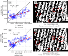
图2
苗期冠层覆盖度的识别结果 (a):EXG预测像素与真实像素数分布图 Distribution of predicted EXG pixel count vs. peal pixel count;(b):EXG识别冠层覆盖度结果 Canopy cover detection results using EXG;(c):EXGR预测像素与真实像素数分布图 Distribution of predicted EXGR pixel count vs. real pixel count;(d):EXGR识别冠层覆盖度结果 Canopy cover detection results using EXGR"
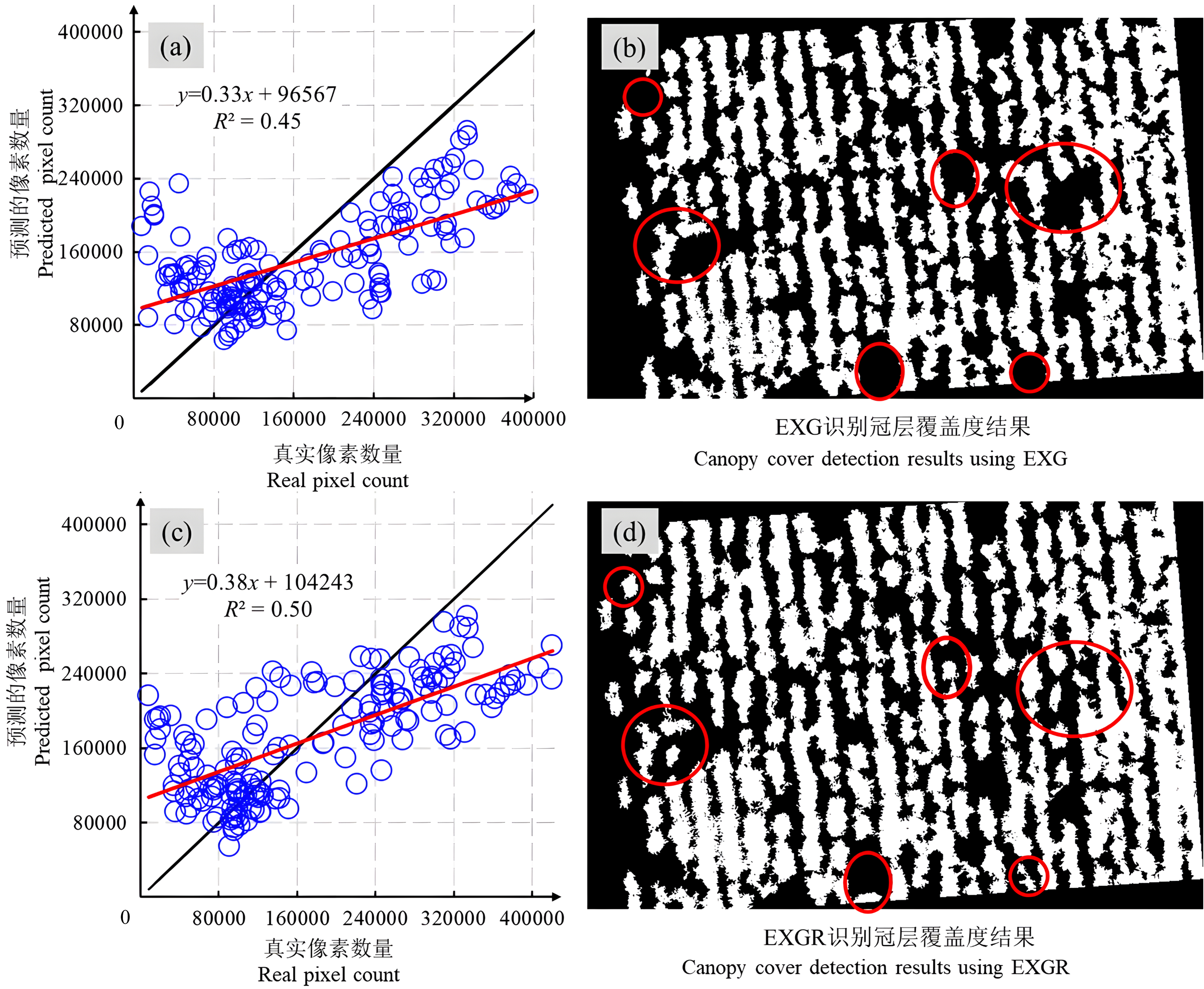
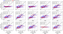
图3
分蘖数的估算结果"

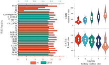
图4
特征重要性"

表3
苗情等级的监测精度"
| 苗情等级 Class | 精度指标 Metrics | 随机森林 RF | 极端梯度提升 XGBOOST | 梯度提升决策树 GBDT | 决策树 DT |
|---|---|---|---|---|---|
| 1 | 像素精度 PA | 0.90 | 1.00 | 0.95 | 0.88 |
| 召回率 R | 1.00 | 0.32 | 0.95 | 0.79 | |
| 2 | 像素精度 PA | 0.83 | 0.57 | 0.86 | 0.70 |
| 召回率 R | 0.94 | 0.64 | 0.86 | 0.83 | |
| 3 | 像素精度 PA | 0.83 | 0.57 | 0.80 | 0.73 |
| 召回率 R | 0.77 | 0.18 | 0.84 | 0.55 | |
| 4 | 像素精度 PA | 0.82 | 0.40 | 0.92 | 0.65 |
| 召回率 R | 0.79 | 0.81 | 0.81 | 0.79 | |
| 5 | 像素精度 PA | 0.89 | 0.82 | 0.79 | 0.83 |
| 召回率 R | 0.81 | 0.67 | 0.90 | 0.71 |
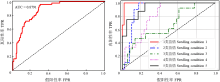
图5
随机森林分类器的AUC曲线"
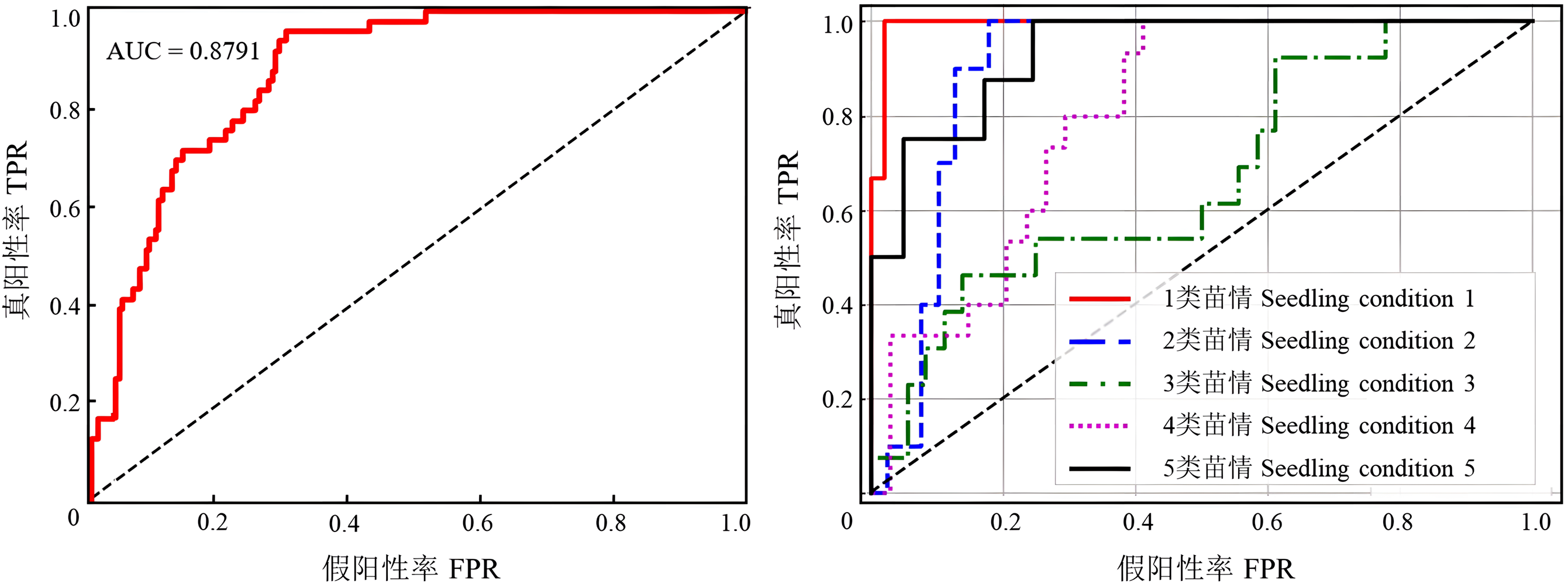
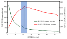
图6
不同高度的监测结果"
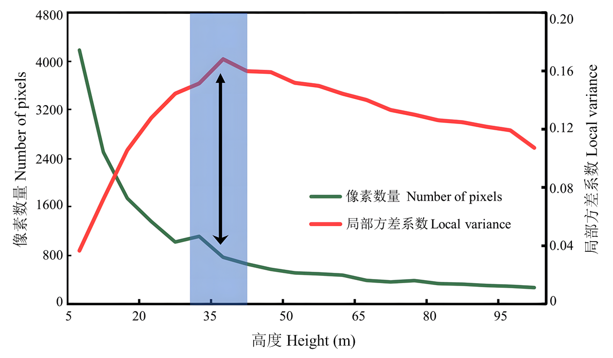
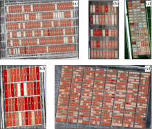
图7
苗情等级监测结果 (a):徐州 Xuzhou;(b):兴化 Xinghua;(c):如皋 Rugao;(d):大丰 Dafeng;(e):连云港 Lianyungang"

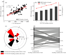
图8
小麦苗情等级变化图 (a):产量与穗数关系 Yield vs. tassels number relationship;(b):不同苗情等级穗数和产量变化 Tassels number and yield variation by seedling condition;(c):越冬前后苗情等级数量 Seedling condition quantities before and after overwintering;(d):越冬前后苗情等级转化关系 Seedling condition transformation before and after overwintering"

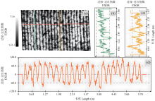
图9
EXGR图像的剖面图 (a):EXGR 图像 EXGR image;(b):小麦的剖面图 Wheat profiles;(c):土壤的剖面图 Soil profiles;(d):行间剖面图 Inter-row profiles"

| [1] |
FAO. The State of Agricultural Commodity Markets 2022. Rome: FAO, 2022.
|
| [2] |
|
| [3] |
IPCC Intergovernmental Panel on Climate Change. Climate Change 2022 - Mitigation of Climate Change: Working Group III Contribution to the Sixth Assessment Report of the Intergovernmental Panel on Climate Change. Cambridge: Cambridge University Press, 2023.
|
| [4] |
|
| [5] |
|
| [6] |
|
| [7] |
|
| [8] |
|
| [9] |
|
| [10] |
费帅鹏, 禹小龙, 兰铭, 李雷, 夏先春, 何中虎, 肖永贵. 基于高光谱遥感和集成学习方法的冬小麦产量估测研究. 中国农业科学, 2021, 54(16): 3417-3427. doi:10.3864/j.issn.0578-1752.2021.16.005.
|
|
|
|
| [11] |
夏天, 吴文斌, 周清波, 周勇. 冬小麦叶面积指数高光谱遥感反演方法对比. 农业工程学报, 2013, 29(3): 139-147.
|
|
|
|
| [12] |
曹中盛, 李艳大, 叶春, 舒时富, 孙滨峰, 黄俊宝, 吴罗发. 基于高光谱的双季稻分蘖数监测模型. 农业工程学报, 2020, 36(4): 185-192.
|
|
|
|
| [13] |
|
| [14] |
王爱冬, 李瑞杰, 冯向前, 洪卫源, 李子秋, 张晓果, 王丹英, 陈松. 基于多角度成像与机器学习的水稻叶面积精确估算. 中国农业科学, 2025, 58(9): 1719-1734. doi:10.3864/j.issn.0578-1752.2025.09.004.
|
|
|
|
| [15] |
冯子恒, 宋莉, 张少华, 井宇航, 段剑钊, 贺利, 尹飞, 冯伟. 基于无人机多光谱和热红外影像信息融合的小麦白粉病监测. 中国农业科学, 2022, 55(5): 890-906. doi:10.3864/j.issn.0578-1752.2022.05.005.
|
|
|
|
| [16] |
|
| [17] |
|
| [18] |
|
| [19] |
|
| [20] |
|
| [21] |
|
| [22] |
|
| [23] |
doi: 10.1186/1471-2105-10-213 pmid: 19591666 |
| [24] |
|
| [25] |
|
| [26] |
|
| [27] |
|
| [28] |
汪小钦, 王苗苗, 王绍强, 吴云东. 基于可见光波段无人机遥感的植被信息提取. 农业工程学报, 2015, 31(5): 152-159.
|
|
|
|
| [29] |
|
| [30] |
|
| [31] |
|
| [32] |
|
| [33] |
|
| [34] |
|
| [35] |
|
| [36] |
|
| [37] |
|
| [38] |
|
| [39] |
|
| [40] |
|
| [41] |
|
| [42] |
|
| [43] |
|
| [44] |
|
| [45] |
郝琪, 陈天陆, 王富贵, 王振, 白岚方, 王永强, 王志刚. 基于无人机多光谱数据和氮素空间分异的玉米冠层氮浓度估算. 作物学报, 2025, 51(1): 189-206.
doi: 10.3724/SP.J.1006.2025.43015 |
|
doi: 10.3724/SP.J.1006.2025.43015 |
|
| [46] |
申哲, 张认连, 龙怀玉, 徐爱国. 基于机器学习方法的宁夏南部土壤质地空间分布研究. 中国农业科学, 2022, 55(15): 2961-2972. doi:10.3864/j.issn.0578-1752.2022.15.008.
|
|
|
|
| [47] |
|
| [1] | 蒲丽霞, 张佳芮, 叶建萍, 黄秀兰, 樊高琼, 杨洪坤. 二氢赤霉素与秸秆覆盖对旱地小麦分蘖成穗与产量的影响[J]. 中国农业科学, 2025, 58(9): 1735-1748. |
| [2] | 王冰洁, 秦诗涵, 李德成, 胡文友, 姜军, 迟凤琴, 张超, 张久明, 徐英德, 汪景宽. 黑龙江省嫩江市土壤容重空间分布格局及传递函数构建[J]. 中国农业科学, 2025, 58(9): 1791-1803. |
| [3] | 李云丽, 刁邓超, 刘雅睿, 孙玉晨, 孟祥宇, 邬陈芳, 汪妤, 吴建辉, 李春莲, 曾庆东, 韩德俊, 郑炜君. 小麦苗期耐热性全基因组关联分析[J]. 中国农业科学, 2025, 58(9): 1663-1683. |
| [4] | 吴郁, 曲翔汝, 杨丹, 伍芩, 陈国跃, 江千涛, 魏育明, 许强. 广泛非靶向代谢组学解析小麦抗条锈病反应中叶绿体代谢产物[J]. 中国农业科学, 2025, 58(7): 1333-1343. |
| [5] | 尹波, 于爱忠, 王鹏飞, 杨学慧, 王玉珑, 尚永盼, 张冬玲, 刘亚龙, 李悦, 王凤. 绿肥还田结合氮肥减施对干旱灌区麦田土壤水热特征及小麦产量的影响[J]. 中国农业科学, 2025, 58(7): 1366-1380. |
| [6] | 潘丽媛, 王永军, 李海军, 侯富, 李菁, 李丽丽, 孙苏阳. 基于转录组和WGCNA筛选小麦籽粒蛋白质累积相关调控基因[J]. 中国农业科学, 2025, 58(6): 1065-1082. |
| [7] | 唐宇, 雷毕欣, 王传伟, 严轩韬, 王浩, 郑杰, 张文静, 马尚宇, 黄正来, 樊永惠. 彩色小麦花青素积累对花后高温胁迫的响应机理[J]. 中国农业科学, 2025, 58(6): 1083-1101. |
| [8] | 张洪程, 邢志鹏, 张瑞宏, 单翔, 奚小波, 程爽, 翁文安, 胡群, 崔培媛, 魏海燕. 小麦整合化无人化丰产栽培的特征与技术途径[J]. 中国农业科学, 2025, 58(5): 864-876. |
| [9] | 张玲, 曹磊, 蔡诚, 颜欣怡, 项博才, 艾佳, 詹新杨, 宋有洪, 朱玉磊. 自然老化条件下冬小麦种子活力及生理指标变化[J]. 中国农业科学, 2025, 58(5): 877-889. |
| [10] | 佘文婷, 孙蕊卿, 党海燕, 李文虎, 张丰, 田怡, 徐隽峰, 丁玉兰, 王朝辉. 我国主要麦区农户小麦籽粒硫的含量、分布及影响因素[J]. 中国农业科学, 2025, 58(5): 956-974. |
| [11] | 刁邓超, 李云丽, 孟祥宇, 季颂涵, 孙玉晨, 马学红, 李杰, 冯永佳, 李春莲, 吴建辉, 曾庆东, 韩德俊, $\boxed{\hbox{王长发}}$, 郑炜君. 小麦TaGRAS34-5A的克隆及耐热功能研究[J]. 中国农业科学, 2025, 58(4): 617-634. |
| [12] | 史帆, 李文广, 易树生, 杨娜, 陈玉萌, 郑伟, 张雪辰, 李紫燕, 翟丙年. 有机无机肥配施下旱地麦田土壤有机碳组分含量的变化特征[J]. 中国农业科学, 2025, 58(4): 719-732. |
| [13] | 牟树佳, 董莉霞, 李广, 燕振刚, 逯玉兰. 基于鲸鱼算法的旱地春小麦农田土壤N2O排放模型参数优化[J]. 中国农业科学, 2025, 58(3): 537-547. |
| [14] | 罗一诺, 李艳霏, 李文虎, 张思琦, 牟文燕, 黄宁, 孙蕊卿, 丁玉兰, 佘文婷, 宋文斌, 李小涵, 石美, 王朝辉. 我国新育成小麦品种(系)籽粒不同部位铁含量及影响因素[J]. 中国农业科学, 2025, 58(3): 416-430. |
| [15] | 仇海龙, 李盼, 张殿凯, 樊志龙, 胡发龙, 陈桂平, 范虹, 何蔚, 殷文, 赵连豪. 西北绿洲灌区麦后复种绿肥对减量施氮春小麦生长及产量的补偿效应[J]. 中国农业科学, 2025, 58(3): 443-459. |
|
||