


中国农业科学 ›› 2025, Vol. 58 ›› Issue (9): 1791-1803.doi: 10.3864/j.issn.0578-1752.2025.09.009
王冰洁1( ), 秦诗涵1, 李德成2, 胡文友2, 姜军2, 迟凤琴3, 张超4, 张久明3, 徐英德1(), 汪景宽1
收稿日期:2024-07-22
接受日期:2024-09-19
出版日期:2025-05-01
发布日期:2025-05-08
通信作者:
联系方式:
王冰洁,E-mail:wxue925@163.com。
基金资助:
WANG BingJie1(), QIN ShiHan1, LI DeCheng2, HU WenYou2, JIANG Jun2, CHI FengQin3, ZHANG Chao4, ZHANG JiuMing3, XU YingDe1(), WANG JingKuan1
Received:2024-07-22
Accepted:2024-09-19
Published:2025-05-01
Online:2025-05-08
摘要:
【目的】 针对东北典型黑土区耕地土壤“变硬”程度及其空间分布不明确问题,以黑龙江省嫩江市为例,对土壤容重空间分布格局进行预测分析,并建立基于有机质含量、紧实度等因素的土壤容重传递函数。【方法】 通过Pearson相关性分析和主成分分析评估土壤属性、气候变量以及地形变量对土壤容重影响的重要程度,运用随机森林模型进行土壤容重预测制图。同时,基于多元线性回归和支持向量机等多种模型构建土壤容重传递函数,并比较其精度。【结果】 土壤容重与土壤含水量、有机质含量呈显著负相关,同时受黏粒、砂粒、pH及年均气温和年均降水量等土壤和气候因素的影响,地形因素影响相对较小。进一步预测制图发现,嫩江市土壤容重均呈现由东北(1.08—1.17 g·cm-3)向西南(1.30—1.40 g·cm-3)逐渐递增,且呈现亚表层土壤容重高于表层的趋势。此外,土壤容重和紧实度随土壤深度增加而增加,但土壤容重变化较缓(1.20—1.44 g·cm-3),而紧实度主要在表层(0—20 cm)迅速增加(变化幅度约为300 kPa);土壤有机质含量随深度增加而降低。通过土壤容重与有机质含量、紧实度等参数进行函数拟合,发现二项式模型和支持向量机分别在有机质—容重、紧实度—容重的拟合中具有较高的R2值,表现出较好的拟合效果和较强的解释力。在亚表层土壤中,通过紧实度构建的土壤容重传递函数预测精度(R2=0.55,RMSE=0.1)高于通过土壤有机质构建的模型(R2=0.43,RMSE=0.12)。【结论】 嫩江市土壤容重呈东北低西南高的分布趋势,且受土壤属性、气候和地形等多种因素的共同影响。基于紧实度的传递函数可作为东北黑土容重变化及“变硬”程度的快速诊断方法。
王冰洁, 秦诗涵, 李德成, 胡文友, 姜军, 迟凤琴, 张超, 张久明, 徐英德, 汪景宽. 黑龙江省嫩江市土壤容重空间分布格局及传递函数构建[J]. 中国农业科学, 2025, 58(9): 1791-1803.
WANG BingJie, QIN ShiHan, LI DeCheng, HU WenYou, JIANG Jun, CHI FengQin, ZHANG Chao, ZHANG JiuMing, XU YingDe, WANG JingKuan. Spatial Distribution Pattern and Transfer Function Construction of Soil Bulk Density in Nenjiang City, Heilongjiang Province[J]. Scientia Agricultura Sinica, 2025, 58(9): 1791-1803.
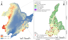
图1
研究区示意图"

表1
土壤容重空间预测的环境变量及数据来源"
| 变量类型 Variable category | 具体指标 Specific indicator | 数据来源 Data sources |
|---|---|---|
| 土壤属性 Soil property | pH、含水量、粉粒、砂粒、黏粒 pH, Water content, Silt, Sand, Clay | SoilGrids250m 2.0 |
| 气候变量 Climate variable | 年均气温、年均降水量 Annual mean temperature (TEM), Annual mean precipitation (PRE) | 中国科学院资源环境科学数据中心( Resources and Environmental Science Data Center( |
| 地形变量 Terrain variable | 高程、坡度、坡向、剖面曲率、平面曲率、地形湿地指数、地形位置指数、 多尺度山谷平坦指数、多尺度脊顶平坦指数 DEM, Slope, Aspect, Profile curvature, Plan curvature, Topographic wetness index (TWI), Terrain position index (TPI), Multi-resolution valley bottom flatness (MrVBF), Multi-scale ridge top flatness (MrRTF) |
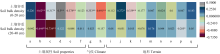
图2
土壤容重和环境因子之间的相关性 a:pH;b:有机质;c:含水量;d:黏粒;e:砂粒;f:粉粒;g:年均气温;h:年均降水量;i:坡度;j:坡向;k:平面曲率;l:剖面曲率;m:高程;n:地形湿地指数;o:地形位置指数;p:多尺度山谷平坦指数;q:多尺度脊顶平坦指数。下同。Pearson相关系数(r)用于评估变量相关性,P判断显著性(* P<0.05,** P<0.01)"
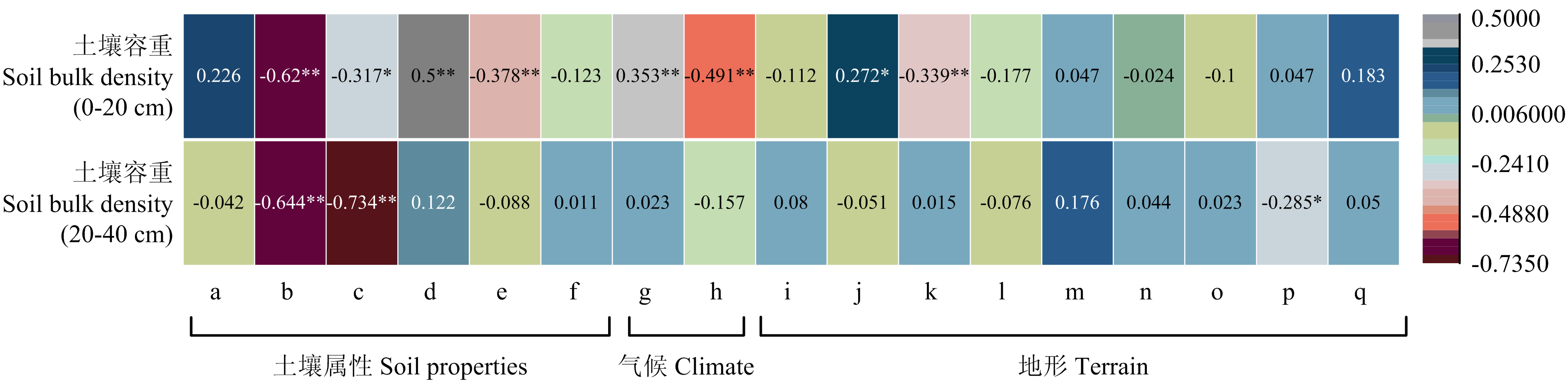
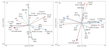
图3
土壤容重主成分分析结果 (a)和(b)图分别为表层土壤(0—20 cm)和亚表层土壤(20—40 cm)中主成分分析结果。不同颜色的箭头代表不同的因素:红色箭头代表土壤容重,绿色箭头代表地理因素,蓝色箭头代表气候因素,粉色箭头代表土壤性质。箭头的长度和与排序轴的夹角分别表示了环境因子的影响大小和相关性强度。TWI、TPI、MrRTF、MrVBF分别代表地形湿地指数、地形位置指数、多尺度脊顶平坦指数和多尺度山谷平坦指数"
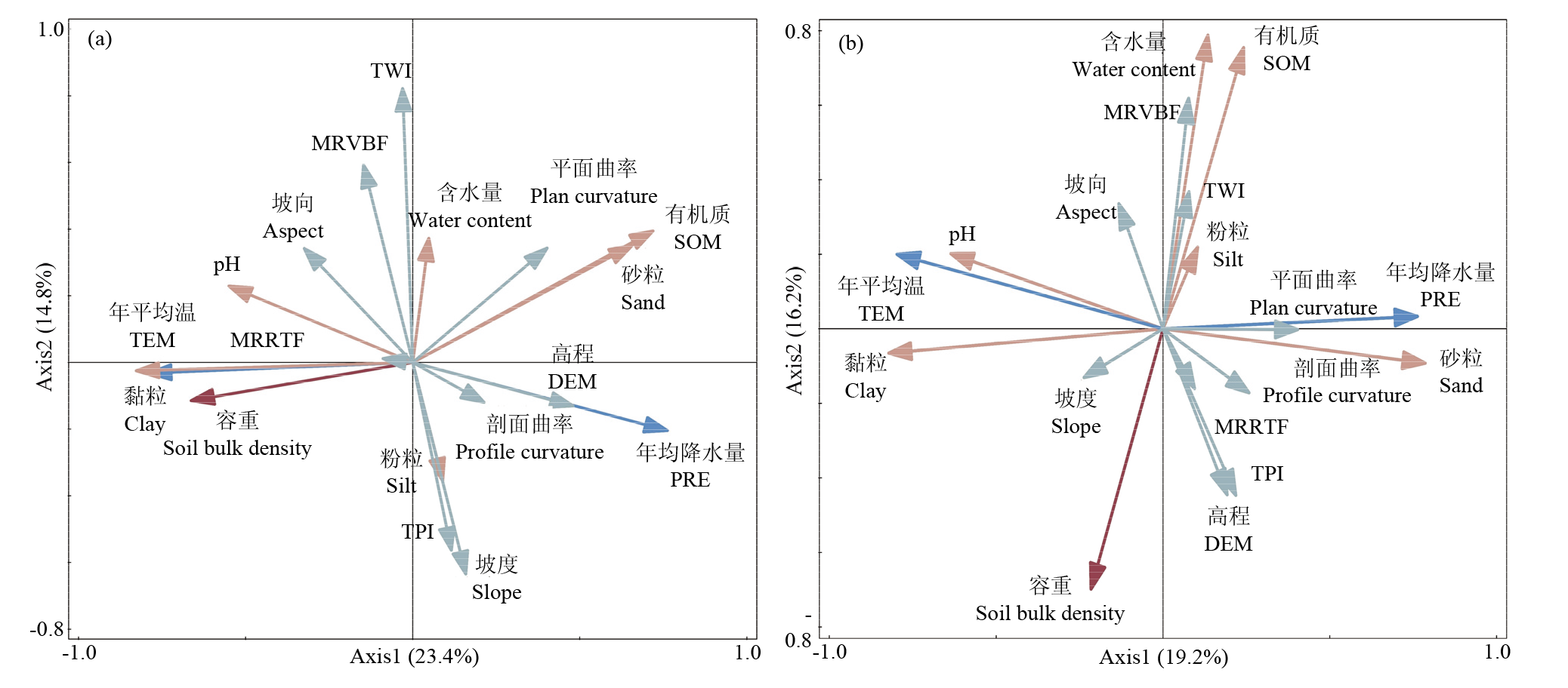
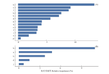
图4
土壤容重随机森林模型环境变量相对重要性 (A)和(B)图分别为表层土壤(0—20 cm)和亚表层土壤(20—40 cm)中环境变量的相对重要性"

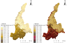
图5
随机森林模型预测土壤容重"

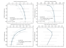
图6
土壤容重、紧实度、有机质含量和含水量随深度变化"
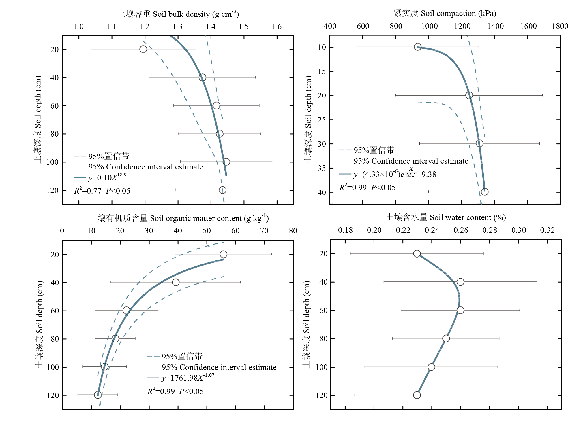
表2
基于土壤有机质含量的土壤容重传递函数比较"
| 方法 Method | 表层土壤 Topsoil | 亚表层土壤Subsoil | ||||
|---|---|---|---|---|---|---|
| R2 | RMSE | RSE | R2 | RMSE | RSE | |
| 多元线性回归 Multiple linear regression | 0.38 | 0.11 | 0.11 | 0.42 | 0.12 | 0.12 |
| 二项式 Binomial | 0.43 | 0.11 | 0.11 | 0.43 | 0.12 | 0.12 |
| 广义线性 Generalized linear | 0.45 | 0.10 | 0.12 | 0.41 | 0.11 | 0.14 |
| 支持向量机 Support vector machines | 0.38 | 0.11 | 0.11 | 0.42 | 0.12 | 0.12 |
| 岭回归 Ridge regression | 0.38 | 0.11 | — | 0.42 | 0.12 | — |
| Lasso回归 Least absolute shrinkage and selection operator | 0.38 | 0.11 | — | 0.42 | 0.12 | — |
表3
基于土壤紧实度的土壤容重传递函数比较"
| 方法 Method | 表层土壤 Topsoil | 亚表层土壤 Subsoil | ||||
|---|---|---|---|---|---|---|
| R2 | RMSE | RSE | R2 | RMSE | RSE | |
| 最小二乘法 Ordinary least squares | 0.16 | 0.13 | 0.13 | 0.55 | 0.10 | 0.10 |
| 广义线性 Generalized linear | 0.16 | 0.13 | 0.15 | 0.07 | 0.10 | 0.13 |
| 支持向量机 Support vector machines | 0.18 | 0.11 | 0.15 | 0.56 | 0.10 | 0.10 |
| 岭回归 Ridge regression | 0.16 | 0.13 | — | — | 0.10 | — |
| Lasso回归 Least absolute shrinkage and selection operator | 0.11 | 0.13 | — | — | — | — |
| [1] |
李保国, 刘忠, 黄峰, 杨晓光, 刘志娟, 万炜, 汪景宽, 徐英德, 李子忠, 任图生. 巩固黑土地粮仓保障国家粮食安全. 中国科学院院刊, 2021, 36(10): 1184-1193.
|
|
|
|
| [2] |
杨婧, 宋茜, 陆苗, 查燕, 吴文斌. 我国“黑土粮仓”建设的科技支撑路径. 中国农业资源与区划, 2024, 46(1): 13-21.
|
|
|
|
| [3] |
刘泽瑾, 焦利民, 连喜红. 1995—2020年气候变化和耕地利用变化对中国耕地气候生产潜力的影响分析. 中国土地科学, 2022, 36(3): 62-73.
|
|
|
|
| [4] |
王瑞, 武威, 刘涛, 孙成明. 耕地土壤容重作用及其调控途径研究进展. 北方园艺, 2020(4): 135-141.
|
|
|
|
| [5] |
卢宏亮, 赵明松, 刘斌寅, 张平, 陆龙妹. 基于随机森林模型的安徽省土壤属性空间分布预测. 土壤, 2019, 51(3): 602-608.
|
|
|
|
| [6] |
|
| [7] |
|
| [8] |
杨之江, 陈效民, 景峰, 郭碧林, 林高哲. 基于GIS和地统计学的稻田土壤养分与重金属空间变异. 应用生态学报, 2018, 29(6): 1893-1901.
doi: 10.13287/j.1001-9332.201806.036 |
|
|
|
| [9] |
张阳, 屠乃美, 谢会雅, 陈舜尧, 邓浏平, 傅雪平, 王旋, 何伟. 茶陵县烟稻复种区土壤养分时空变异特征. 土壤通报, 2021, 52(2): 297-305.
|
|
|
|
| [10] |
刘慧霞, 孙宗玖, 崔雨萱, 董乙强. 新疆北疆荒漠草地土壤容重空间分布格局及其影响因素. 中国草地学报, 2021, 43(2): 82-91.
|
|
|
|
| [11] |
李晓晓, 刘京, 赵世伟, 李婷, 曾宪芳. 西北干旱区县域农田表层土壤容重空间变异性特征. 水土保持学报, 2013, 27(4): 148-151.
|
|
|
|
| [12] |
任丽, 杨联安, 王辉, 杨粉莉, 陈卫军, 张林森, 徐瑾昊. 基于随机森林的苹果区土壤有机质空间预测. 干旱区资源与环境, 2018, 32(8): 141-146.
|
|
|
|
| [13] |
doi: 10.1016/j.patcog.2019.01.036 pmid: 30765897 |
| [14] |
|
| [15] |
|
| [16] |
|
| [17] |
韩光中, 王德彩, 谢贤健. 中国主要土壤类型的土壤容重传递函数研究. 土壤学报, 2016, 53(1): 93-102.
|
|
|
|
| [18] |
任利东, 王丽, 林琳, 张斌. 农田土壤机械压实研究进展与展望. 土壤学报, 2023, 60(3): 610-626.
|
|
|
|
| [19] |
钟骁勇, 李洪义, 郭冬艳, 谢模典, 赵婉如, 胡碧峰. 基于多源环境变量和随机森林模型的江西省耕地土壤pH值空间预测. 自然资源遥感, 2023, 35(4): 178-185.
|
|
|
|
| [20] |
|
| [21] |
周鑫洋, 黄青, 刘航. 近10年嫩江市大豆种植结构空间演变研究. 中国农业资源与区划, 2023, 44(12): 77-83.
|
|
|
|
| [22] |
鲍士旦. 土壤农化分析. 3版. 北京: 中国农业出版社, 2000.
|
|
|
|
| [23] |
张万涛, 吉静怡, 李彬彬, 王菊, 许明祥. 黄土高原不同地貌区农田土壤有机质预测方法研究. 植物营养与肥料学报, 2021, 27(4): 583-594.
|
|
|
|
| [24] |
陈宣强, 赵明松, 卢宏亮, 徐少杰, 邱士其, 胡克宏. 基于3种地理加权回归方法的安徽省土壤pH空间预测制图对比研究. 地理科学, 2023, 43(1): 173-183.
doi: 10.13249/j.cnki.sgs.2023.01.018 |
|
doi: 10.13249/j.cnki.sgs.2023.01.018 |
|
| [25] |
李顿, 王雪梅, 李坤玉, 安柏耸. 基于变量筛选与机器学习算法的渭-库绿洲土壤有机质含量估测研究. 地球与环境, 2024, 52(3): 375-385.
|
|
|
|
| [26] |
方匡南, 吴见彬, 朱建平, 谢邦昌. 随机森林方法研究综述. 统计与信息论坛, 2011, 26(3): 32-38.
|
|
|
|
| [27] |
席承藩. 土壤分类学. 北京: 中国农业出版社, 1994.
|
|
|
|
| [28] |
柴华, 何念鹏. 中国土壤容重特征及其对区域碳贮量估算的意义. 生态学报, 2016, 36(13): 3903-3910.
|
|
|
|
| [29] |
|
| [30] |
胡培. 土壤颗粒组成与有机质含量对水稻土容重的影响. 农村经济与科技, 2021, 32(19): 48-51.
|
|
|
|
| [31] |
刘战东, 张凯, 米兆荣, 秦安振, 黄超, 马岩川, 余轩, 孙景生, 黄世清, 李长有, 张景忙. 不同土壤容重条件下水分亏缺对作物生长和水分利用的影响. 水土保持学报, 2019, 33(2): 115-120.
|
|
|
|
| [32] |
|
| [33] |
于冬雪, 贾小旭, 黄来明, 邵明安, 王娇. 黄土区不同土层土壤容重空间变异与模拟. 土壤学报, 2019, 56(1): 55-64.
|
|
|
|
| [34] |
吴文斌, 杨鹏, 唐华俊,
|
|
|
|
| [35] |
doi: 10.1007/s10661-020-08692-6 pmid: 33128682 |
| [36] |
乔磊, 张吴平, 黄明镜, 王国芳, 任健. 基于MGWRK的土壤有机质制图及驱动因素研究. 中国农业科学, 2020, 53(9): 1830-1844. doi: 10.3864/j.issn.0578-1752.2020.09.011.
|
|
|
|
| [37] |
汪景宽, 徐英德, 丁凡, 高晓丹, 李双异, 孙良杰, 安婷婷, 裴久渤, 李明, 王阳, 张维俊, 葛壮. 植物残体向土壤有机质转化过程及其稳定机制的研究进展. 土壤学报, 2019, 56(3): 528-540.
|
|
|
|
| [38] |
|
| [39] |
邹养军, 马锋旺, 韩明玉, 吴亚维. 土壤紧实胁迫与植物抗胁迫响应机理研究进展. 干旱地区农业研究, 2007, 25(6): 212-215, 236.
|
|
|
|
| [40] |
王辉, 王全九, 邵明安. 表层土壤容重对黄土坡面养分随径流迁移的影响. 水土保持学报, 2007, 21(3): 10-13, 18.
|
|
|
|
| [41] |
刘武仁, 郑金玉, 罗洋, 郑洪兵, 李瑞平, 李伟堂. 不同耕层构造对土壤硬度和含水量的影响. 玉米科学, 2013, 21(6): 76-80.
|
|
|
|
| [42] |
郝翔翔, 邹文秀, 韩晓增. 长期不同利用方式对黑土剖面中有机质化学组成的影响. 土壤学报, 2022, 59(5): 1228-1237.
|
|
|
|
| [43] |
|
| [44] |
熊佰炼, 高扬, 彭韬, 颜雄. 喀斯特坡地浅层岩溶裂隙土壤团聚体稳定性与养分垂向变化特征. 土壤学报, 2021, 58(6): 1472-1485.
|
|
|
|
| [45] |
徐爽, 阚雨晨. 不同肥力水平的土壤紧实度与含水量的相关度分析. 中国农学通报, 2022, 38(36): 94-100.
doi: 10.11924/j.issn.1000-6850.casb2021-1223 |
|
doi: 10.11924/j.issn.1000-6850.casb2021-1223 |
|
| [46] |
张鹏飞, 贾小旭, 赵春雷, 邵明安. 初始容重对土壤水分特征曲线的影响. 干旱区研究, 2022, 39(4): 1174-1180.
doi: 10.13866/j.azr.2022.04.18 |
|
doi: 10.13866/j.azr.2022.04.18 |
|
| [47] |
|
| [48] |
马婧怡, 贾宁凤, 程曼. 黄土丘陵区不同土地利用方式下土壤水分变化特征. 生态学报, 2018, 38(10): 3471-3481.
|
|
|
|
| [49] |
杜康, 张北赢. 黄土丘陵区不同土地利用方式土壤水分变化特征. 水土保持研究, 2020, 27(6): 72-76.
|
|
|
|
| [50] |
韩晓增, 李娜. 中国东北黑土地研究进展与展望. 地理科学, 2018, 38(7): 1032-1041.
doi: 10.13249/j.cnki.sgs.2018.07.004 |
|
doi: 10.13249/j.cnki.sgs.2018.07.004 |
| [1] | 冯晓琳, 张楚天, 许晨阳, 耿增超, 胡斐南, 杜伟. 陕西省土壤无机碳的时空分布特征及影响因素[J]. 中国农业科学, 2024, 57(8): 1517-1532. |
| [2] | 杨建君, 盖浩, 张梦璇, 蔡育蓉, 王力艳, 王立刚. 深松结合秸秆还田对黑土孔隙结构的影响[J]. 中国农业科学, 2023, 56(5): 892-906. |
| [3] | 李亚贞, 韩天富, 曲潇琳, 马常宝, 都江雪, 柳开楼, 黄晶, 刘淑军, 刘立生, 申哲, 张会民. 我国水稻的肥料贡献率时空变化及影响因素[J]. 中国农业科学, 2023, 56(4): 674-685. |
| [4] | 李思奇, 王志慧, 常玉瑶, 吉艳芝, 郭艳杰, 刘俊, 张丽娟, 王娅静. 河北永定河流域葡萄园土壤硝态氮空间分布特征[J]. 中国农业科学, 2023, 56(17): 3399-3411. |
| [5] | 孙涛, 冯晓敏, 高新昊, 邓艾兴, 郑成岩, 宋振伟, 张卫建. 多样化种植对土壤团聚体组成及其有机碳和全氮含量的影响[J]. 中国农业科学, 2023, 56(15): 2929-2940. |
| [6] | 陈硕桐, 夏鑫, 丁元君, 冯潇, 刘晓雨, Marios Drosos, 李恋卿, 潘根兴. 不同形态秸秆还田下乌栅土耕层土壤有机质含量与组成变化[J]. 中国农业科学, 2023, 56(13): 2518-2529. |
| [7] | 余维宝, 李楠, 寇一泓, 曹新有, 司纪升, 韩守威, 李豪圣, 张宾, 王法宏, 张海林, 赵鑫, 李华伟. 山东省强筋小麦品质评价及与气象因子关系分析[J]. 中国农业科学, 2022, 55(22): 4383-4397. |
| [8] | 申哲,张认连,龙怀玉,徐爱国. 基于机器学习方法的宁夏南部土壤质地空间分布研究[J]. 中国农业科学, 2022, 55(15): 2961-2972. |
| [9] | 张维理, 傅伯杰, 徐爱国, 杨鹏, 陈涛, 张认连, 史舟, 吴文斌, 李建兵, 冀宏杰, 刘峰, 雷秋良, 李兆君, 冯瑶, 李艳丽, 徐用兵, 裴玮. 中国土壤调查结果的地统计特征[J]. 中国农业科学, 2022, 55(13): 2572-2583. |
| [10] | 崔帅,刘烁然,王寅,夏晨真,焉莉,冯国忠,高强. 吉林省旱地土壤有效硫含量及其与土壤有机质和全氮的关系[J]. 中国农业科学, 2022, 55(12): 2372-2383. |
| [11] | 李少华,王云鹏,王荣成,尹萍,李向东,郑方强. 玉米田桃蛀螟幼虫的空间分布型与抽样技术[J]. 中国农业科学, 2022, 55(10): 1961-1970. |
| [12] | 任俊波, 杨雪丽, 陈平, 杜青, 彭西红, 郑本川, 雍太文, 杨文钰. 种间距离对玉米-大豆带状套作土壤理化性状及根系空间分布的影响[J]. 中国农业科学, 2022, 55(10): 1903-1916. |
| [13] | 房蕊,于镇华,李彦生,谢志煌,刘俊杰,王光华,刘晓冰,陈渊,刘居东,张少庆,吴俊江,Stephen J HERBERT,金剑. 大气CO2浓度和温度升高对农田土壤碳库及微生物群落结构的影响[J]. 中国农业科学, 2021, 54(17): 3666-3679. |
| [14] | 乔磊,张吴平,黄明镜,王国芳,任健. 基于MGWRK的土壤有机质制图及驱动因素研究[J]. 中国农业科学, 2020, 53(9): 1830-1844. |
| [15] | 张振华,丁建丽,王敬哲,葛翔宇,王瑾杰,田美玲,赵启东. 集成土壤-环境关系与机器学习的干旱区土壤属性数字制图[J]. 中国农业科学, 2020, 53(3): 563-573. |
|
||