Scientia Agricultura Sinica ›› 2021, Vol. 54 ›› Issue (10): 2084-2094.doi: 10.3864/j.issn.0578-1752.2021.10.005
• TILLAGE & CULTIVATION·PHYSIOLOGY & BIOCHEMISTRY·AGRICULTURE INFORMATION TECHNOLOGY • Previous Articles Next Articles
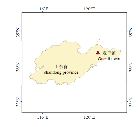
LI MeiXuan1( ),ZHU XiCun1,2(),BAI XueYuan1,PENG YuFeng1,TIAN ZhongYu1,JIANG YuanMao3
| [1] |
ZHAO D, REDDY K R, KAKANI V G, REDDY V R. Nitrogen deficiency effects on plant growth, leaf photosynthesis, and hyperspectral reflectance properties of sorghum. European Journal of Agronomy, 2005,22(4):391-403.
doi: 10.1016/j.eja.2004.06.005 |
| [2] | 田歌, 李慧峰, 田蒙, 刘晓霞, 陈倩, 朱占玲, 姜远茂, 葛顺峰. 不同水肥一体化方式对苹果氮素吸收利用特性及产量和品质的影响. 应用生态学报, 2020,31(6):1867-1874. |
| TIAN G, LI H F, TIAN M, LIU X X, CHEN Q, ZHU Z L, JIANG Y M, GE S F. Effects of different integration of water and fertilizer modes on the absorption and utilization of nitrogen fertilizer and fruit yield and quality of apple trees. Chinese Journal of Applied Ecology, 2020,31(6):1867-1874. (in Chinese) | |
| [3] | 王凌, 赵庚星, 朱西存, 王瑞燕, 常春艳. 花期苹果树冠氮素营养状况的卫星遥感反演. 应用生态学报, 2013,24(10):2863-2870. |
| WANG L, ZHAO G X, ZHU X C, WANG R Y, CHANG C Y. Satellite remote sensing retrieval of canopy nitrogen nutritional status of apple trees at blossom stage. Chinese Journal of Applied Ecology, 2013,24(10):2863-2870. (in Chinese) | |
| [4] | 赵静, 李志铭, 鲁力群, 贾鹏, 杨焕波, 兰玉彬. 基于无人机多光谱遥感图像的玉米田间杂草识别. 中国农业科学, 2020,53(8):1545-1555. |
| ZHAO J, LI Z M, LU L Q, JIA P, YANG H B, LAN Y B. Weed identification in maize field based on multi-spectral remote sensing of unmanned aerial vehicle. Scientia Agricultura Sinica, 2020,53(8):1545-1555. (in Chinese) | |
| [5] | 刘昌华, 王哲, 陈志超, 周兰, 岳学智, 苗宇新. 基于无人机遥感影像的冬小麦氮素监测. 农业机械学报, 2018,49(6):207-214. |
| LIU C H, WANG Z, CHEN Z C, ZHOU L, YUE X Z, MIAO Y X. Nitrogen monitoring of winter wheat based on unmanned aerial vehicle remote sensing image. Transactions of the Chinese Society for Agricultural Machinery, 2018,49(6):207-214. (in Chinese) | |
| [6] |
YUE J B, YANG G J, LI C C, LI Z H, WANG Y J, FENG H K, XU B. Estimation of winter wheat above-ground biomass using unmanned aerial vehicle-based snapshot hyperspectral sensor and crop height improved models. Remote Sensing, 2017,9(7):708-726.
doi: 10.3390/rs9070708 |
| [7] |
CINAT P, DI GENNARO S F, BERTON A, MATESE A. Comparison of unsupervised algorithms for vineyard canopy segmentation from UAV multispectral images. Remote Sensing, 2019,11(9):1023-1046.
doi: 10.3390/rs11091023 |
| [8] | 师翊, 耿楠, 胡少军, 张志毅, 张晶. 基于随机森林回归算法的苹果树冠层光照分布模型. 农业机械学报, 2019,50(5):214-222. |
| SHI Y, GENG N, HU S J, ZHANG Z Y, ZHANG J. Illumination distribution model of apple tree canopy based on random forest regression algorithm. Transactions of the Chinese Society for Agricultural Machinery, 2019,50(5):214-222. (in Chinese) | |
| [9] |
ZHOU K, DENG X Q, YAO X, TIAN Y C, CAO W X, ZHU Y, USTIN S L, CHENG T. Assessing the spectral properties of sunlit and shaded components in rice canopies with near-ground imaging spectroscopy data. Sensors, 2017,17(3):578-594.
doi: 10.3390/s17030578 |
| [10] | 于东方, 殷建平, 张国敏. 一种基于灰度直方图的遥感影像阴影自动检测方法. 计算机工程与科学, 2008,30(12):43-44. |
| YU D F, YIN J P, ZHANG G M. An automatic shadow detection method for remote sensing images based on gray histogram. Computer Engineering & Science, 2008,30(12):43-44. (in Chinese) | |
| [11] | 许妙忠, 余志惠. 高分辨率卫星影像中阴影的自动提取与处理. 测绘信息与工程, 2003(1):20-22. |
| XU M Z, YU Z H. Automated extraction of shadows in very-high resolution spatial satellite images. Journal of Geomatics, 2003(1):20-22. (in Chinese) | |
| [12] | 虢建宏, 田庆久, 吴昀昭. 遥感影像阴影多波段检测与去除理论模型研究. 遥感学报, 2006(2):151-159. |
| GUO J H, TIAN Q J, WU J Z. Study on multispectral detecting shadow areas and a theoretical model of removing shadows from remote sensing images. National Remote Sensing Bulletin, 2006(2):151-159. (in Chinese) | |
| [13] |
PU R L, LANDRY S. A comparative analysis of high spatial resolution IKONOS and WorldView-2 imagery for mapping urban tree species. Remote Sensing of Environment, 2012,124:516-533.
doi: 10.1016/j.rse.2012.06.011 |
| [14] |
TITS L, SOMERS B, STUCKENS J, FARIFTEH J, COPPIN P. Integration of in situ measured soil status and remotely sensed hyperspectral data to improve plant Production system monitoring: concept, perspectives and limitations. Remote Sensing of Environment, 2013,128:197-211.
doi: 10.1016/j.rse.2012.10.006 |
| [15] | 奚祯苑, 刘丽娟, 陆灯盛, 葛宏立, 陈耀亮. 基于线性混合像元分解技术提取山核桃空间分布. 林业科学, 2015,51(10):43-52. |
| XI Z Y, LIU L J, LU D S, GE H L, CHEN Y L. Mapping of carya cathayensis spatial distribution with linear spectral mixture model. Scientia Silvae Sinicae, 2015,51(10):43-52. (in Chinese) | |
| [16] |
MILAS A S, AREND K, MAYER C, SIMONSON M A, MACKEY M. Different colours of shadows: Classification of UAV images. International Journal of Remote Sensing, 2017,38(8/10):3084-3100.
doi: 10.1080/01431161.2016.1274449 |
| [17] | 焦俊男, 石静, 田庆久, 高林, 徐念旭. 多光谱影像NDVI阴影影响去除模型. 遥感学报, 2020,24(1):53-66. |
| JIAO J N, SHI J, TIAN Q J, GAO L, XU N X. Research on multispectral-image-based NDVI shadow-effect-eliminating model. National Remote Sensing Bulletin, 2020,24(1):53-66. (in Chinese) | |
| [18] |
ZHANG L F, SUN X J, WU T X, ZHANG H M. An analysis of shadow effects on spectral vegetation indexes using a ground-based imaging spectrometer. IEEE Geoscience and Remote Sensing Letters, 2015,12(11):2188-2192.
doi: 10.1109/LGRS.2015.2450218 |
| [19] |
江洪, 袁亚伟, 王森. 阴影消除植被指数(SEVI)去除地形本影和落影干扰的性能评估与应用. 地球信息科学学报, 2019,21(12):1977-1986.
doi: 10.12082/dqxxkx.2019.190409 |
|
JIANG H, YUAN Y W, WANG S. Shadow-eliminated vegetation index (SEVI) for removing terrain shadow effect: Evaluation and application. Journal of Geo-information Science, 2019,21(12):1977-1986. (in Chinese)
doi: 10.12082/dqxxkx.2019.190409 |
|
| [20] | 柳晓农, 江洪, 汪小钦. 构建植被区分阴影消除植被指数提取山地植被信息. 农业工程学报, 2019,35(20):135-144. |
| LIU X N, JIANG H, WANG X Q. Extraction of mountain vegetation information based on vegetation distinguished and shadow eliminated vegetation index. Transactions of the Chinese Society of Agricultural Engineering, 2019,35(20):135-144. (in Chinese) | |
| [21] | 许章华, 刘健, 余坤勇, 刘涛, 龚从宏, 唐梦雅, 谢婉君, 李增禄. 阴影植被指数SVI的构建及其在四种遥感影像中的应用效果. 光谱学与光谱分析, 2013,33(12):3359-3365. |
| XU Z H, LIU J, YU K Y, LIU T, GONG C H, TANG M Y, XIE W J, LI Z L. Construction of vegetation shadow index (SVI) and application effects in four remote sensing images. Spectroscopy and Spectral Analysis, 2013,33(12):3359-3365. (in Chinese) | |
| [22] | 许章华, 林璐, 王前锋, 黄旭影, 刘健, 余坤勇, 陈崇成. 归一化阴影植被指数NSVI的构建及其应用效果(英文). 红外与毫米波学报, 2018,37(2):154-162. |
| XU Z H, LIN L, WANG Q F, HUANG X Y, LIU J, XU K Y, CHEN C C. Construction and application effects of normalized shaded vegetation index. Journal of Infrared and Millimeter Waves, 2018,37(2):154-162. (in Chinese) | |
| [23] |
XU N X, TIAN J, TIAN Q J, XU K J, TANG S F. Analysis of vegetation red edge with different illuminated/shaded canopy proportions and to construct normalized difference canopy shadow index. Remote Sensing, 2019,11(10):1192-1207.
doi: 10.3390/rs11101192 |
| [24] | 杨贵军, 万鹏, 于海洋, 徐波, 冯海宽. 无人机多光谱影像辐射一致性自动校正. 农业工程学报, 2015,31(9):147-153. |
| YANG G J, WAN P, YU H Y, XU B, FENG H K. Automatic radiation uniformity correction of multispectral imagery acquired with unmanned aerial vehicle. Transactions of the Chinese Society of Agricultural Engineering, 2015,31(9):147-153. (in Chinese) | |
| [25] | 蒲智, 杨辽, 白洁. 基于面向对象技术的高分辨率遥感影像的阴影检测与去除. 遥感技术与应用, 2008,23(6):735-738. |
| PU Z, YANG L, BAI J. Shadow detection and removal based on object-oriented method in high spatial resolution remote sense image. Remote Sensing Technology and Application, 2008,23(6):735-738. (in Chinese) | |
| [26] |
JIANG Z Y, HUETE A R, CHEN J, CHEN Y H, LI J, YAN G J, ZHANG X Y. Analysis of NDVI and scaled difference vegetation index retrievals of vegetation fraction. Remote Sensing of Environment, 2006,101(3):366-378.
doi: 10.1016/j.rse.2006.01.003 |
| [27] | 陈红艳, 赵庚星, 陈敬春, 王瑞燕, 高明秀. 基于改进植被指数的黄河口区盐渍土盐分遥感反演. 农业工程学报, 2015,31(5):107-114. |
| CHEN H Y, ZHAO G X, CHEN J C, WANG R Y, GAO M X. Remote sensing inversion of saline soil salinity based on modified vegetation index in estuary area of Yellow River. Transactions of the Chinese Society of Agricultural Engineering, 2015,31(5):107-114. (in Chinese) | |
| [28] | FU P, MEACHAM-HENSOLD K, GUAN K Y, WU J, BERNACCHI C. Estimating photosynthetic traits from reflectance spectra: A synthesis of spectral indices, numerical inversion, and partial least square regression. Plant Cell & Environment, 2020,43(5):1241-1258. |
| [29] | ALI A M, DARVISHZADEH R, SKIDMORE A, GARA T W, O’CONNOR B, ROEOESLI C, HEURICH M, PAGANINI M. Comparing methods for mapping canopy chlorophyll content in a mixed mountain forest using Sentinel-2 data. International Journal of Applied Earth Observation and Geoinformation, 2020,87:14. |
| [30] | 张卓, 龙慧灵, 王崇倡, 杨贵军. 冬小麦叶片光合特征高光谱遥感估算模型的比较研究. 中国农业科学, 2019,52(4):616-628. |
| ZHANG Z, LONG H L, WANG C C, YANG G J. Comparison of hyperspectral remote sensing estimation models based on photosynthetic characteristics of winter wheat leaves. Scientia Agricultura Sinica, 2019,52(4):616-628. (in Chinese) | |
| [31] | SHI Z, WANG Q L, PENG J, JI W J, LIU H J, LI X, RAPHAEL A V R. Development of a national VNIR soil-spectral library for soil classification and prediction of organic matter concentrations. Science China(Earth Sciences), 2014,57(7):1671-1680. |
| [32] |
YAN G J, LI L Y, COY A, MU X H, CHEN S B, XIE D H, ZHANG W M, SHEN Q F, ZHOU H M. Improving the estimation of fractional vegetation cover from UAV RGB imagery by colour unmixing. ISPRS Journal of Photogrammetry and Remote Sensing, 2019,158:23-34.
doi: 10.1016/j.isprsjprs.2019.09.017 |
| [33] |
ABOUTALEBI M, TORRES-RUA A F, KUSTAS W P, NIETO H, COOPMANS C, MCKEE M. Assessment of different methods for shadow detection in high-resolution optical imagery and evaluation of shadow impact on calculation of NDVI, and evapotranspiration. Irrigation Science, 2019,37(3):407-429.
doi: 10.1007/s00271-018-0613-9 |
| [34] |
NOH H, ZHANG Q. Shadow effect on multi-spectral image for detection of nitrogen deficiency in corn. Computers and Electronics in Agriculture, 2012,83:52-57.
doi: 10.1016/j.compag.2012.01.014 |
| [35] |
FILELLA I, SERRANO L, SERRA J, PENUELAS J. Evaluating Wheat Nitrogen Status with Canopy Reflectance Indices and Discriminant Analysis. Crop Science, 1995,35(5):1400-1405.
doi: 10.2135/cropsci1995.0011183X003500050023x |
| [36] | 陈鹏飞, 梁飞. 基于低空无人机影像光谱和纹理特征的棉花氮素营养诊断研究. 中国农业科学, 2019,52(13):2220-2229. |
| CHEN P F, LIANG F. Cotton nitrogen nutrition diagnosis based on spectrum and texture feature of images from low altitude unmanned aerial vehicle. Scientia Agricultura Sinica, 2019,52(13):2220-2229. (in Chinese) | |
| [37] |
ZHOU K, GUO Y J, GENG Y N, ZHU Y, CAO W X, TIAN Y C. Development of a novel bidirectional canopy reflectance model for row-planted rice and wheat. Remote Sensing, 2014,6(8):7632-7659.
doi: 10.3390/rs6087632 |
| [38] | 曾琪, 余坤勇, 姚雄, 郑文英, 张今朝, 艾婧文, 刘健. 基于PROSAIL辐射传输模型的毛竹林分冠层反射率模拟研究. 植物科学学报, 2017,35(5):699-707. |
| ZENG Q, XU K Y, YAO X, ZHENG W Y, ZHANG J Z, AI J W, LIU J. Research on canopy reflectance modeling of Phyllostachys pubescens forest based on the PROSAIL canopy radiative transfer model. Plant Science Journal, 2017,35(5):699-707. (in Chinese) |
| [1] | FENG ZiHeng,SONG Li,ZHANG ShaoHua,JING YuHang,DUAN JianZhao,HE Li,YIN Fei,FENG Wei. Wheat Powdery Mildew Monitoring Based on Information Fusion of Multi-Spectral and Thermal Infrared Images Acquired with an Unmanned Aerial Vehicle [J]. Scientia Agricultura Sinica, 2022, 55(5): 890-906. |
| [2] | WANG ShuTing,KONG YuGuang,ZHANG Zan,CHEN HongYan,LIU Peng. SPAD Value Inversion of Cotton Leaves Based on Satellite-UAV Spectral Fusion [J]. Scientia Agricultura Sinica, 2022, 55(24): 4823-4839. |
| [3] | HUANG Chong,HOU XiangJun. Crop Classification with Time Series Remote Sensing Based on Bi-LSTM Model [J]. Scientia Agricultura Sinica, 2022, 55(21): 4144-4157. |
| [4] | MA Xiao,CHEN PengFei. Improvement of Row Detection Method Before Wheat Canopy Closure Using Multispectral Images of UAV Image [J]. Scientia Agricultura Sinica, 2022, 55(20): 3926-3938. |
| [5] | MA YuYang,GUAN HaiXiang,YANG HaoXuan,SHAO Shuai,SHAO YiQun,LIU HuanJun. A New Method to Improve the Accuracy of Digital Elevation Model in Northeast China by Using Terrain, Soil and Crop Information [J]. Scientia Agricultura Sinica, 2021, 54(8): 1715-1727. |
| [6] | FengZhi SHI,RuiYan WANG,YuHuan LI,Hong YAN,XiaoXin ZHANG. LAI Estimation Based on Multi-Spectral Remote Sensing of UAV and Its Application in Saline Soil Improvement [J]. Scientia Agricultura Sinica, 2020, 53(9): 1795-1805. |
| [7] | ZHAO Jing,LI ZhiMing,LU LiQun,JIA Peng,YANG HuanBo,LAN YuBin. Weed Identification in Maize Field Based on Multi-Spectral Remote Sensing of Unmanned Aerial Vehicle [J]. Scientia Agricultura Sinica, 2020, 53(8): 1545-1555. |
| [8] | WANG KeJian,LI Li,LÜ Qiang,YI ShiLai,ZHENG YongQiang,XIE RangJin,MA YanYan,HE ShaoLan,DENG Lie. UAV Spray Technology for the Citrus Orchard: Taking Control of the Diaphorina citri and Phyllocnistis citrella as Examples [J]. Scientia Agricultura Sinica, 2020, 53(17): 3509-3517. |
| [9] | ZHU XiaoYu,XU DaWei,XIN XiaoPing,SHEN BeiBei,DING Lei,WANG Xu,CHEN BaoRui,YAN RuiRui. The Spatial-Temporal Distribution of Different Grassland Types in Hulunber Grassland Based on Remote Sensing from 1992 to 2015 [J]. Scientia Agricultura Sinica, 2020, 53(13): 2715-2727. |
| [10] | CHENG Wei, XIN XiaoPing. Analysis of Spatial-Temporal Characteristics of Drought Variation in Grassland Area of Inner Mongolia Based on TVDI [J]. Scientia Agricultura Sinica, 2020, 53(13): 2728-2742. |
| [11] | GONG ChangWei,MA Yu,YANG Rui,RUAN YanWei,WANG XueGui,LIU Yue. Effect of Nozzle Type on the Spray Performance of Plant Protection Unmanned Aerial Vehicle (UAV) [J]. Scientia Agricultura Sinica, 2020, 53(12): 2385-2398. |
| [12] | CHEN PengFei, LIANG Fei. Cotton Nitrogen Nutrition Diagnosis Based on Spectrum and Texture Feature of Images from Low Altitude Unmanned Aerial Vehicle [J]. Scientia Agricultura Sinica, 2019, 52(13): 2220-2229. |
| [13] | ZHANG ChunLan, YANG GuiJun, LI HeLi, TANG FuQuan, LIU Chang, ZHANG LiYan. Remote Sensing Inversion of Leaf Area Index of Winter Wheat Based on Random Forest Algorithm [J]. Scientia Agricultura Sinica, 2018, 51(5): 855-867. |
| [14] | LIU HuanJun, YU ShengNan, ZHANG XinLe, GUO Dong, YIN JiXian. Timeliness Analysis of Crop Remote Sensing Classification One Crop A Year [J]. Scientia Agricultura Sinica, 2017, 50(5): 830-839. |
| [15] | CHEN ZhiFang, SONG Ni, WANG JingLei, SUN JingSheng. Leaf Water Potential Estimating Models of Winter Wheat Based on Hyperspectral Remote Sensing [J]. Scientia Agricultura Sinica, 2017, 50(5): 871-880. |
|
||