






中国农业科学 ›› 2026, Vol. 59 ›› Issue (22): 5126-5139.doi: 10.3864/j.issn.0578-1752.2026.22.012
成金礼1( ), 杨烨峰1, 张业珠1, 杨紫琳1, 王童瑶1, 王程毅1, 程媛媛1, 彭红礼1, 岳天祥2, 李启权1()
收稿日期:2026-01-09
接受日期:2026-06-05
出版日期:2026-11-19
发布日期:2026-11-19
通信作者:
联系方式:
成金礼,E-mail:1487744059@qq.com。
基金资助:
CHENG JinLi1(), YANG YeFeng1, ZHANG YeZhu1, YANG ZiLin1, WANG TongYao1, WANG ChengYi1, CHENG YuanYuan1, PENG HongLi1, YUE TianXiang2, LI QiQuan1()
Received:2026-01-09
Accepted:2026-06-05
Published:2026-11-19
Online:2026-11-19
摘要:
【目的】掌握土壤容重特征及其驱动机制,为精准评估土壤物理质量和碳储量潜力以及优化耕地压实防控提供科学依据。【方法】2023年在四川盆地典型紫色丘陵区布设310个采样点,剔除异常值后获得305个有效表层(0—20 cm)土壤样品,采用相关分析、方差分析和随机森林模型,定量解析多种环境因子对土壤容重空间分异特征的驱动作用及不同土地利用类型下容重差异及主控因素。【结果】(1)研究区表层土壤容重在0.74—1.65 g·cm-3之间,平均值为1.32 g·cm-3。不同土地利用类型下土壤容重分异显著(P<0.01),表现为果园(1.43 g·cm-3)和旱地(1.40 g·cm-3)显著高于林草地(1.32 g·cm-3),呈现显著的旱作压实效应;而水旱轮作地(1.25 g·cm-3)与水田(0.92 g·cm-3)土壤容重显著偏低。(2)随机森林模型结果显示,土壤有机碳(SOC)含量(19.62%)和土地利用类型(19.47%)是驱动全区土壤容重变异的首要因子,其重要程度远超地形与土壤质地。(3)不同土地利用类型下土壤容重的主控机制存在分化:果园、旱地、水旱轮作地及林草地中,SOC为首要控制因子,相对重要性达22.34%—34.34%;而在长期淹水的水田生境下,反映水分条件和潜育化等成土过程差异的土壤亚类成为绝对主控因素,其相对重要性达52.47%。【结论】紫色丘陵区表层土壤容重并非沿单一压实或疏松方向演变,而是在土地利用驱动下形成“旱作压实、水旱轮作缓冲、水田解体”的差异化路径。SOC主导旱地、果园、水旱轮作地和林草地的容重变异,反映了碳输入对表层结构重塑的核心作用;而水田容重受潜育化等水分主导成土过程控制,表现为极低容重。基于这一机制,紫色土区土壤物理质量提升应由统一治理转向分类调控:旱作地应强化有机碳补充并减少压实扰动,水田应优化排灌与晾田过程,水旱轮作地则应维持合理干湿交替和水肥平衡,以发挥其兼具固碳与结构缓冲的利用优势。
成金礼, 杨烨峰, 张业珠, 杨紫琳, 王童瑶, 王程毅, 程媛媛, 彭红礼, 岳天祥, 李启权. 四川盆地典型紫色土区不同土地利用类型的土壤容重特征及影响因素[J]. 中国农业科学, 2026, 59(22): 5126-5139.
CHENG JinLi, YANG YeFeng, ZHANG YeZhu, YANG ZiLin, WANG TongYao, WANG ChengYi, CHENG YuanYuan, PENG HongLi, YUE TianXiang, LI QiQuan. Characteristics and Influencing Factors of Soil Bulk Density Under Different Land Use Types in the Typical Purple Soil Area of the Sichuan Basin[J]. Scientia Agricultura Sinica, 2026, 59(22): 5126-5139.
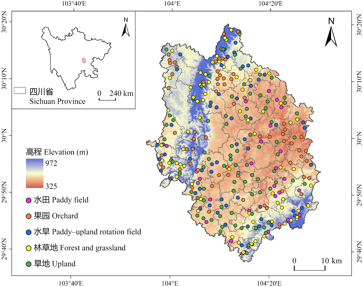
图1
研究区位置及土壤采样点分布图"
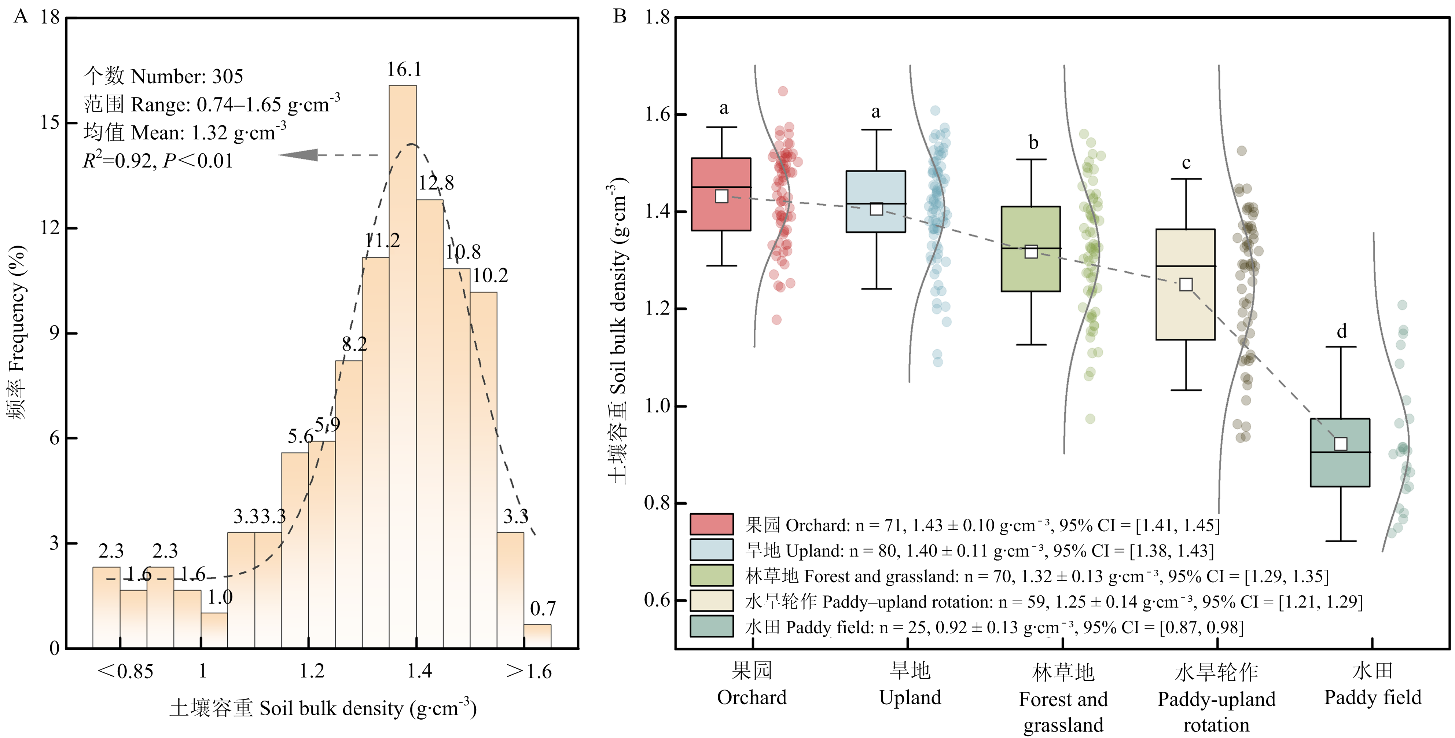
图2
土壤容重频率分布(A)和不同土地利用类型下土壤容重的差异(B) 图b中箱体中的横线表示中位数,箱体中正方形表示平均值,箱体上方的不同小写字母代表不同土地利用类型之间土壤容重存在显著差异(P<0.05)。95%CI表示95%置信区间"
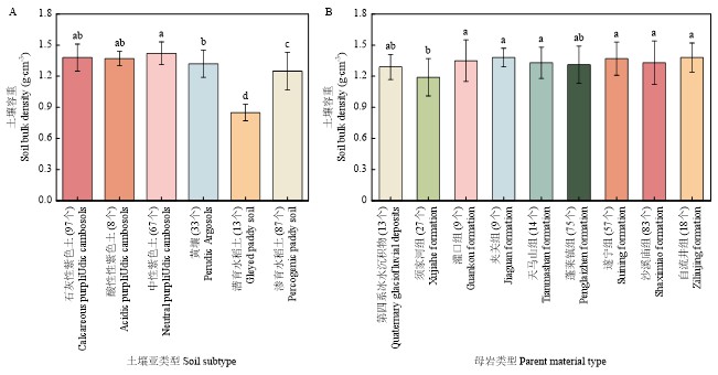
图3
土壤容重在不同土壤亚类(A)和成土母岩(B)的差异 括号中的数字为各类型的土壤样本数"
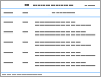
表1
土壤容重的分级标准及不同级别的比例"
| 容重等级Soil bulk density grade | 分级标准Classification standard (g·cm-3) | 个数Number | 比例Proportion (%) |
|---|---|---|---|
| Ⅰ级(高)Grade I (High) | 1.10-1.25 | 45 | 14.75 |
| Ⅱ级(较高)Grade II (Relatively high) | 1.25-1.35, 1.00-1.10 | 72 | 23.61 |
| Ⅲ级(中)Grade III (Medium) | 1.35-1.45 | 88 | 28.85 |
| Ⅳ级(较低)Grade IV (Relatively low) | 1.45-1.55, 0.90-1.00 | 76 | 24.92 |
| Ⅴ级(低)Grade V (Low) | >1.55,≤0.90 | 24 | 7.87 |
| 总计Total | 305 | 100.00 |
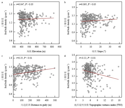
图4
土壤容重与不同地形因子的关系"
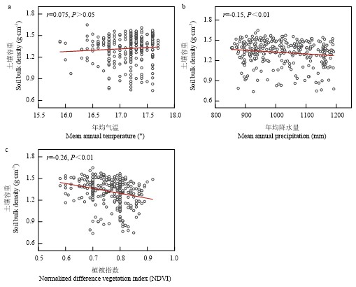
图5
土壤容重与年均气温(a)、年均降水量(b)和植被指数(c)的关系"
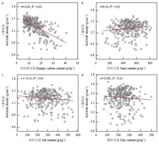
图6
土壤容重与土壤有机碳含量(a)和土壤颗粒组成(b—d)的关系"
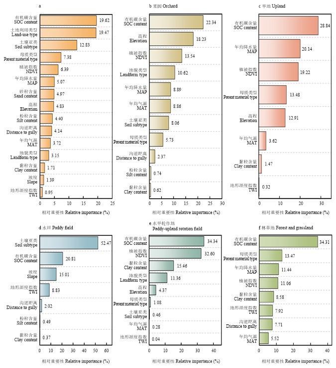
图7
各影响因素对土壤容重的相对重要性(a)和不同土地利用类型下主要驱动因素的差异(b—f)"
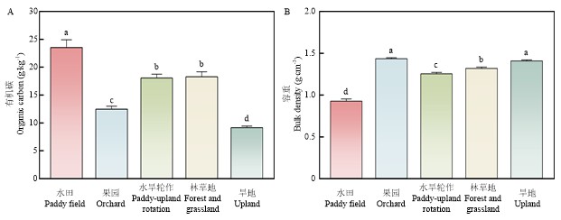
图8
不同土地利用类型下有机碳含量(A)和表层土壤容重(B) 柱形体上方的不同字母代表不同土地利用方式之间土壤有机碳或容重存在显著差异(P<0.05)"
| [1] |
|
| [2] |
|
| [3] |
王晓盼, 王昌昆, 孙海军, 郭志英, 刘杰, 高磊, 马海艺, 袁自然, 姚成硕, 潘贤章. 基于随机森林的黑土地尺度耕地土壤容重传递函数构建[J]. 土壤学报, 2025, 62(4): 970-982.
|
|
|
|
| [4] |
|
| [5] |
|
| [6] |
|
| [7] |
李孟霞, 文国松, 李永忠. 作物对土壤压实胁迫响应研究进展[J]. 山东农业科学, 2019, 51(1): 154-160, 167.
|
|
|
|
| [8] |
|
| [9] |
|
| [10] |
洪成, 张学军, 尹殿胜, 徐艳, 陈俊英. 容重对砂土渗透系数的影响[J]. 合肥工业大学学报(自然科学版), 2019, 42(8): 1102-1105.
|
|
|
|
| [11] |
|
| [12] |
|
| [13] |
狄晓双, 武红旗, 贾宏涛, 张文太, 谷海斌, 邵明轩, 盛建东. 新疆主要草地土壤容重与有机碳含量关系模型构建[J]. 土壤通报, 2021, 52(6): 1323-1329.
|
|
|
|
| [14] |
柴华, 何念鹏. 中国土壤容重特征及其对区域碳贮量估算的意义[J]. 生态学报, 2016, 36(13): 3903-3910.
|
|
|
|
| [15] |
|
| [16] |
|
| [17] |
|
| [18] |
|
| [19] |
丁司丞, 方超, 卓玛拉姆, 冯兆忠. 基于机器学习模型的农田土壤容重模拟及其影响因素[J]. 应用生态学报, 2025, 36(9): 2827-2835.
|
|
|
|
| [20] |
于冬雪, 贾小旭, 黄来明, 邵明安, 王娇. 黄土区不同土层土壤容重空间变异与模拟[J]. 土壤学报, 2019, 56(1): 55-64.
|
|
|
|
| [21] |
王思敏, 张红丽, 张恒硕, 左启林, 查同刚. 晋西黄土区典型小流域不同土层土壤容重分布特征及其影响因素[J]. 生态学杂志, 2024, 43(3): 609-615.
|
|
|
|
| [22] |
薛晶玲, 成金礼, 陈丹, 毛雅若, 陈鑫怡, 齐浩然, 费米嘉, 郭聪慧, 李启权. 四川盆地紫色土耕层有机碳含量变化特征及影响因素[J]. 中国生态农业学报(中英文), 2025, 33(1): 1-13.
|
|
|
|
| [23] |
鲍玉海, 丛佩娟, 冯伟, 王海燕, 贺秀斌, 田风霞. 西南紫色土区水土流失综合治理技术体系[J]. 水土保持通报, 2018, 38(3): 143-150.
|
|
|
|
| [24] |
|
| [25] |
王齐齐, 徐虎, 马常宝, 薛彦东, 王传杰, 徐明岗, 张文菊. 西部地区紫色土近30年来土壤肥力与生产力演变趋势分析[J]. 植物营养与肥料学报, 2018, 24(6): 1492-1499.
|
|
|
|
| [26] |
|
| [27] |
|
| [28] |
|
| [29] |
|
| [30] |
|
| [31] |
鲁如坤. 土壤农业化学分析方法[M]. 北京: 中国农业科学技术出版社, 2000.
|
|
|
|
| [32] |
李艾雯, 李文丹, 宋靓颖, 冉敏, 陈丹, 成金礼, 齐浩然, 郭聪慧, 李启权. 四川盆地耕地表层土壤容重缺失数据填补方法[J]. 土壤学报, 2025, 62(1): 40-53.
|
|
|
|
| [33] |
|
| [34] |
赵世伟. 黄土高原子午岭植被恢复下土壤有机碳-结构-水分环境演变特征[D]. 杨凌: 西北农林科技大学, 2012.
|
|
|
|
| [35] |
|
| [36] |
|
| [37] |
|
| [38] |
罗由林, 李启权, 王昌全, 张新, 张维, 贾荔, 袁大刚, 吴德勇. 四川省仁寿县土壤有机碳空间分布特征及其主控因素[J]. 中国生态农业学报, 2015, 23(1): 34-42.
|
|
|
|
| [39] |
|
| [40] |
胡国成, 章明奎. 氧化铁对土粒强胶结作用的矿物学证据[J]. 土壤通报, 2002, 33(1): 25-27.
|
|
|
|
| [41] |
赵月, 鲍雪莲, 梁超, 王钢, 解宏图. 压实对农田土壤特性的影响及应对措施[J]. 土壤通报, 2023, 54(6): 1457-1469.
|
|
|
|
| [42] |
白一茹, 王幼奇, 展秀丽. 陕北农牧交错带土地利用方式对土壤物理性质及分布特征的影响[J]. 中国农业科学, 2013, 46(8): 1619-1627. DOI: 10.3864/j.issn.0578-1752.2013.08.011.
|
|
|
|
| [43] |
|
| [44] |
|
| [45] |
彭星星, 郭正, 张玉娇, 李军. 长期有机肥与化肥配施对渭北旱塬苹果园水分生产力和土壤有机碳含量影响的定量模拟[J]. 植物营养与肥料学报, 2018, 24(1): 33-43.
|
|
|
|
| [46] |
王福文, 鲁泽让, 王婷, 赵吉霞, 李永梅, 李琬婷, 邓东梅, 李庆华, 王自林, 范茂攀. 不同绿肥轮作翻压对AMF群落和土壤有机碳组分的影响. 农业环境科学学报, 2026, 45(6): 1503-1513.
|
|
|
|
| [47] |
尉庆丰, 王益权, 何瑞林, 雷兴权. 应用暗沟排水技术改良陕南冬水田的效果[J]. 西北农业大学学报, 1991(2): 27-31.
|
|
|
| [1] | 魏圆慧, 余益辉, 李子钧, 丁文杰, 涂文龙, 毛艳玲. 长期施肥对黄泥田土壤有机碳化学结构与固碳细菌群落结构的影响[J]. 中国农业科学, 2026, 59(5): 1020-1033. |
| [2] | 韩小雨, 朱玉萍, 刘红芳, 孙志梅, 张秀芝, 高洪军, 彭畅, 张淑香. 长期施肥措施下黑土活性碳组分和碳水解酶的动态变化[J]. 中国农业科学, 2026, 59(18): 4092-4104. |
| [3] | 王冰洁, 秦诗涵, 李德成, 胡文友, 姜军, 迟凤琴, 张超, 张久明, 徐英德, 汪景宽. 黑龙江省嫩江市土壤容重空间分布格局及传递函数构建[J]. 中国农业科学, 2025, 58(9): 1791-1803. |
| [4] | 张昊鑫, 于晟玥, 雷秋良, 杜新忠, 张继宗, 安妙颖, 樊秉乾, 罗加法, 刘宏斌. 基于RothC模型的东北旱地和稻田土壤有机碳动态变化模拟研究[J]. 中国农业科学, 2025, 58(8): 1564-1578. |
| [5] | 吴欣珈, 薛玮, 严翊丹, 聂莹莹, 叶立明, 徐丽君. 呼伦贝尔土壤有机碳时空变异特征及其影响因素[J]. 中国农业科学, 2025, 58(6): 1145-1158. |
| [6] | 史帆, 李文广, 易树生, 杨娜, 陈玉萌, 郑伟, 张雪辰, 李紫燕, 翟丙年. 有机无机肥配施下旱地麦田土壤有机碳组分含量的变化特征[J]. 中国农业科学, 2025, 58(4): 719-732. |
| [7] | 马鹤逍, 葛国龙, 张向前, 路战远, 王满秀, 戎美仁, 师晶晶, 张德健, 孙雪萍. 不同作物轮作系统对土壤易氧化有机碳和碳库活度差异性的影响[J]. 中国农业科学, 2025, 58(24): 5201-5215. |
| [8] | 靳晓莹, 肖柄政, 张天津, 刘忠宽, 冯伟, 杜章留. 冬绿肥提升滨海盐碱土团聚性及植物源与微生物源有机碳固存[J]. 中国农业科学, 2025, 58(20): 4203-4215. |
| [9] | 马玉洁, 李旭, 翟英芳, 李敬宇, 付鑫, 彭正萍. 秸秆还田方式和施氮量对土壤有机碳组分及酶活性的影响[J]. 中国农业科学, 2025, 58(12): 2397-2410. |
| [10] | 陈武荣, 肖霜霜, 肖峻, 陈丹. 喀斯特峰丛洼地利用方式对土壤有机碳及其活性组分的影响[J]. 中国农业科学, 2025, 58(10): 1969-1981. |
| [11] | 高尚洁, 刘杏认, 李迎春, 柳晓婉. 施用生物炭和秸秆还田对农田温室气体排放及增温潜势的影响[J]. 中国农业科学, 2024, 57(5): 935-949. |
| [12] | 孙悦, 任科宇, 邹洪琴, 高洪军, 张水清, 李德近, 李冰洁, 廖楚芊, 段英华, 徐明岗. 黑土与潮土铁氧化物结合态有机碳对长期秸秆还田的响应[J]. 中国农业科学, 2024, 57(19): 3823-3834. |
| [13] | 王文俊, 梁爱珍, 张延, 陈学文, 黄丹丹. 黑土区保护性耕作土壤有机碳动态的模型模拟研究[J]. 中国农业科学, 2024, 57(10): 1943-1960. |
| [14] | 庞津雯, 王钰皓, 陶宏扬, 卫婷, 高飞, 刘恩科, 贾志宽, 张鹏. 生物炭不同添加量对旱作覆膜农田土壤团聚体特性及有机碳含量的影响[J]. 中国农业科学, 2023, 56(9): 1729-1743. |
| [15] | 董秀, 张燕, MUNYAMPIRWA Tito, 陶海宁, 沈禹颖. 长期保护性耕作对黄土高原旱作农田土壤碳含量及转化酶活性的影响[J]. 中国农业科学, 2023, 56(5): 907-919. |
|
||
