


中国农业科学 ›› 2025, Vol. 58 ›› Issue (6): 1145-1158.doi: 10.3864/j.issn.0578-1752.2025.06.008
吴欣珈1( ), 薛玮2, 严翊丹1, 聂莹莹1, 叶立明3, 徐丽君1()
收稿日期:2024-05-14
接受日期:2024-11-11
出版日期:2025-03-25
发布日期:2025-03-25
通信作者:
联系方式:
吴欣珈,E-mail:15975592102@163.com。
基金资助:
WU XinJia1(), XUE Wei2, YAN YiDan1, NIE YingYing1, YE LiMing3, XU LiJun1()
Received:2024-05-14
Accepted:2024-11-11
Published:2025-03-25
Online:2025-03-25
摘要:
【目的】 分析中国呼伦贝尔土壤有机碳(SOC)含量的时空分布特征及其驱动因素,以期为土壤碳储量管理和生态系统服务提供科学依据。【方法】 采用点对点采样调查方法,收集1980年(历史数据)和2022年的土壤有机碳实测数据,涉及农田、草原、森林和湿地4种土地利用类型。利用回归克里金方法,结合温度、降水、坡度、海拔和归一化植被指数(NDVI)等环境变量,对SOC含量及其变化进行空间预测。【结果】 (1)1980年SOC含量受这5个因子显著影响(P<0.05),而2022年SOC含量主要受海拔、坡度、降水量和NDVI的显著影响,温度影响不显著(P=0.07)。两个时期的模型拟合精度分别为R 2=0.60和R 2=0.63,表明预测模型具有一定的可靠性。(2)空间预测数据显示,1980年呼伦贝尔SOC平均含量为40.29 g·kg-1,而2022年降为31.75 g·kg-1。两个时期土壤SOC含量在空间上的变化趋势相似,表现为中部地区含量较高,西部和东部地区含量较低。(3)不同土地利用方式下SOC含量的变化存在差异。近40年间,农田、草原、森林和湿地土壤的SOC含量分别下降了4.59 g·kg-1(13.3%)、6.08 g·kg-1(18.7%)、11.16 g·kg-1(23.0%)和7.20 g·kg-1(24.4%)。【结论】 呼伦贝尔地区SOC含量的空间分布,1980年与2022年保持一致,且不同土地利用方式下的SOC含量均呈现下降趋势。土地利用方式的转变是影响SOC空间分布变化的关键因素。此外,环境变量对SOC变化的预测存在不确定性,未来的研究需考虑其动态变化特性。在呼伦贝尔地区,森林-草原过渡带和森林-农田过渡带具有碳汇潜力,而草原、中部高海拔森林区域和农田区域则可能是碳源区域。
吴欣珈, 薛玮, 严翊丹, 聂莹莹, 叶立明, 徐丽君. 呼伦贝尔土壤有机碳时空变异特征及其影响因素[J]. 中国农业科学, 2025, 58(6): 1145-1158.
WU XinJia, XUE Wei, YAN YiDan, NIE YingYing, YE LiMing, XU LiJun. Temporal and Spatial Variation Characteristics of Soil Organic Carbon in Hulunbuir and Its Influencing Factors[J]. Scientia Agricultura Sinica, 2025, 58(6): 1145-1158.

图1
呼伦贝尔地区土地类型及本研究采样点分布图"
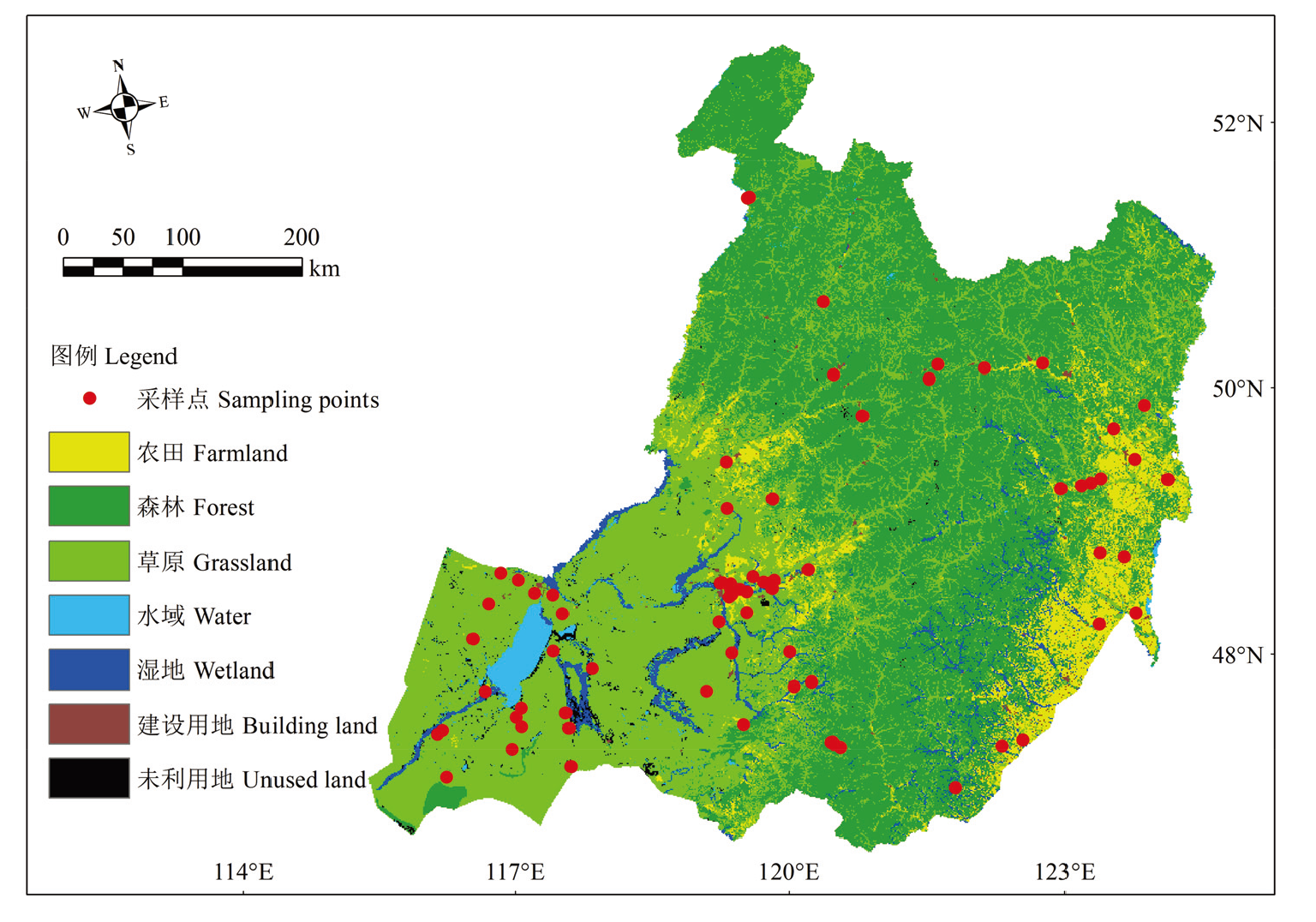
表1
1980年和2022年影响土壤有机碳含量的GAM模型因素选择"
| 年份 Year | 影响因素 Influence factor | 标准化系数 Standardized coefficient | 显著性 Significance | 拟合度 R2 |
|---|---|---|---|---|
| 1980 | 海拔Elevation | 14.134 | <0.001 | 0.72 |
| 坡度Slope | 1.601 | <0.001 | ||
| 温度Temperature | -13.709 | <0.001 | ||
| 降水量Precipitation | 0.240 | <0.05 | ||
| 归一化植被指数Normalized difference vegetation index | 8.280 | <0.05 | ||
| 2022 | 海拔Elevation | 0.024 | <0.001 | 0.71 |
| 坡度Slope | 1.102 | <0.01 | ||
| 降水量Precipitation | 5.758 | <0.001 | ||
| 归一化植被指数Normalized difference vegetation index | 2.785 | <0.05 |
表2
构建土壤有机碳含量不同模型的拟合效果"
| 年份 Year | 编号 Number | 模型函数 Model function | 块金值 Nugget value | 偏基台值 Partial abutment value | 平均值误差 ME (g·kg-1) | 均方根误差 RMSE (g·kg-1) | 平均绝对误差MAE (g·kg-1) | 拟合度 R2 |
|---|---|---|---|---|---|---|---|---|
| 1980 | 1 | 指数函数Exponential function | 1.02 | 0.00 | -0.04 | 5.28 | 5.04 | 0.48 |
| 2 | 指数函数Exponential function | 1.51 | 0.00 | -0.04 | 5.28 | 6.12 | 0.48 | |
| 3 | 高斯函数Gauss function | 1.02 | 0.00 | -0.06 | 5.37 | 4.99 | 0.47 | |
| 4 | 指数函数Exponential function | 0.10 | 0.00 | -0.04 | 5.28 | 1.58 | 0.48 | |
| 5 | 指数函数Exponential function | 1.02 | 0.00 | -0.06 | 5.48 | 4.97 | 0.46 | |
| 6 | 指数函数Exponential function | 1.02 | 0.00 | -0.19 | 5.60 | 4.67 | 0.45 | |
| 7 | 高斯函数Gauss function | 1.68 | 0.16 | -0.06 | 5.37 | 6.70 | 0.47 | |
| 8 | 高斯函数Gauss function | 1.02 | 0.00 | -0.01 | 5.20 | 5.07 | 0.48 | |
| 9 | 高斯函数Gauss function | 1.02 | 0.00 | -0.06 | 5.37 | 5.61 | 0.47 | |
| 10 | 指数函数Exponential function | 43.33 | 0.00 | 0.08 | 5.24 | 6.72 | 0.48 | |
| 11 | J-Bessel | 0.02 | 1.68 | -0.01 | 0.81 | 0.22 | 0.65 | |
| 2022 | 1 | 指数函数Exponential function | 0.88 | 0.12 | 0.00 | 1.04 | 4.57 | 0.48 |
| 2 | 指数函数Exponential function | 1.00 | 0.10 | 0.02 | 4.92 | 4.49 | 0.47 | |
| 3 | 指数函数Exponential function | 1.29 | 0.12 | 0.01 | 4.80 | 5.22 | 0.48 | |
| 4 | 高斯函数Gauss function | 1.24 | 0.34 | 0.01 | 4.92 | 5.68 | 0.47 | |
| 5 | 指数函数Exponential function | 1.02 | 0.00 | 0.00 | 4.81 | 4.58 | 0.48 | |
| 6 | 高斯函数Gauss function | 1.34 | 0.00 | 0.04 | 4.95 | 5.17 | 0.46 | |
| 7 | 稳定Stable | 1.01 | 0.00 | -0.01 | 4.72 | 4.64 | 0.49 | |
| 8 | 稳定Stable | 1.01 | 0.00 | 0.00 | 4.68 | 4.64 | 0.49 | |
| 9 | 多项式5 Polynomial 5 | 0.27 | 0.33 | 0.02 | 0.99 | 0.78 | 0.62 | |
| 10 | 指数函数Exponential function | 27.33 | 0.00 | 0.10 | 4.80 | 5.32 | 0.48 | |
| 11 | 孔洞效应Hole effect | 22.25 | 5.29 | 0.22 | 5.25 | 5.59 | 0.43 | |
| 12 | J-Bessel | 20.49 | 6.66 | 0.11 | 4.63 | 5.25 | 0.50 | |
| 13 | 稳定Stable | 24.29 | 3.18 | 0.11 | 4.81 | 5.33 | 0.48 |
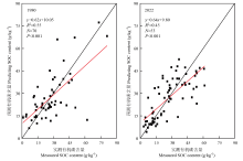
图2
1980和2022年呼伦贝尔土壤有机碳含量的预测值与实测值"
表3
回归克里金模型下呼伦贝尔不同年份SOC含量交叉验证对比结果"
| 年份 Year | MAE (g·kg-1) | RMSE (g·kg-1) | R² |
|---|---|---|---|
| 1980 | 9.16 | 11.83 | 0.60 |
| 2022 | 7.13 | 10.92 | 0.63 |
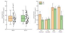
图3
1980和2022年呼伦贝尔不同土地利用方式下的土壤有机碳含量 图柱上不同小写字母表示不同处理间差异显著(P<0.05)。下同"

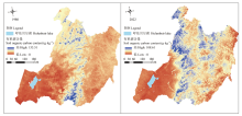
图4
1980和2022年呼伦贝尔土壤表层有机碳含量预测值空间分布"

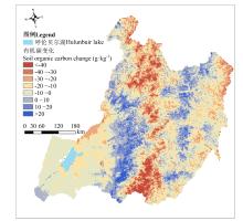
图5
1980—2022年呼伦贝尔土壤表层有机碳含量变化的空间分布"

表4
1980—2022年呼伦贝尔地区各土地利用类型SOC含量的变化"
| 土地利用方式 Land use patterns | 1980 SOC (g·kg-1) | 2022 SOC (g·kg-1) | SOC变化 SOC change (g·kg-1) | 变化率 Rate of change (%) | 面积 Area (km2) |
|---|---|---|---|---|---|
| 农田Farmland | 34.64 | 30.05 | -4.59 | -13.3% | 19815.80 |
| 草原Grassland | 32.46 | 26.38 | -6.08 | -18.7% | 122530.40 |
| 森林Forest | 48.48 | 37.32 | -11.16 | -23.0% | 95727.30 |
| 湿地Wetland | 29.53 | 22.33 | -7.20 | -24.4% | 11461.50 |
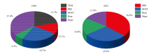
图6
1980和2022年环境因子对呼伦贝尔土壤有机碳含量相对重要性 TEM:温度;PRE:降水量;NDVI:归一化植被指数;Dem:海拔;Slope:坡度"

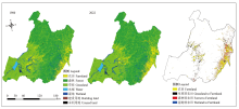
图7
呼伦贝尔1980年代末和2022年的土地利用方式及变化"

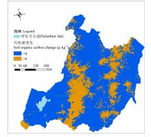
图8
呼伦贝尔土壤有机碳含量变化的空间分布图"

| [1] |
|
| [2] |
doi: 10.1007/s11442-019-1583-4 |
| [3] |
doi: 10.1111/gcb.15110 pmid: 32267043 |
| [4] |
|
| [5] |
|
| [6] |
|
| [7] |
|
| [8] |
|
| [9] |
|
| [10] |
doi: 10.1007/s40333-024-0052-9 |
| [11] |
|
| [12] |
|
| [13] |
|
| [14] |
|
| [15] |
|
| [16] |
|
| [17] |
|
| [18] |
doi: 10.1016/j.jenvman.2010.01.001 pmid: 20106585 |
| [19] |
|
| [20] |
|
| [21] |
|
| [22] |
|
| [23] |
|
| [24] |
|
| [25] |
辛晓平, 丁蕾, 程伟, 朱晓昱, 陈宝瑞, 刘钟龄, 何广礼, 青格勒, 杨桂霞, 唐华俊. 北方草地及农牧交错区草地植被碳储量及其影响因素. 中国农业科学, 2020, 53(13): 2757-2768. doi: 10.3864/j.issn.0578-1752.2020.13.022.
|
|
|
|
| [26] |
|
| [27] |
|
| [28] |
|
| [29] |
|
| [30] |
|
| [31] |
|
| [32] |
|
| [33] |
|
| [34] |
|
| [35] |
|
| [36] |
|
| [37] |
|
| [38] |
|
| [39] |
|
| [40] |
|
| [41] |
|
| [42] |
|
| [43] |
薛玮, 徐丽君, 聂莹莹, 吴欣珈, 严翊丹, 叶立明, 柳新伟. 影响呼伦贝尔草原土壤有机碳空间变异的主导因素. 中国农业科学, 2024, 57(12): 2378-2389. doi: 10.3864/j.issn.0578-1752.2024.12.009.
|
|
|
|
| [44] |
doi: S0048-9697(18)32985-1 pmid: 30180331 |
| [45] |
|
| [46] |
|
| [47] |
|
| [48] |
|
| [49] |
|
| [50] |
|
| [51] |
|
| [52] |
doi: S0048-9697(18)31169-0 pmid: 29635197 |
| [53] |
|
| [54] |
|
| [55] |
|
| [56] |
|
| [57] |
|
| [58] |
|
| [59] |
|
| [1] | 史帆, 李文广, 易树生, 杨娜, 陈玉萌, 郑伟, 张雪辰, 李紫燕, 翟丙年. 有机无机肥配施下旱地麦田土壤有机碳组分含量的变化特征[J]. 中国农业科学, 2025, 58(4): 719-732. |
| [2] | 高尚洁, 刘杏认, 李迎春, 柳晓婉. 施用生物炭和秸秆还田对农田温室气体排放及增温潜势的影响[J]. 中国农业科学, 2024, 57(5): 935-949. |
| [3] | 孙悦, 任科宇, 邹洪琴, 高洪军, 张水清, 李德近, 李冰洁, 廖楚芊, 段英华, 徐明岗. 黑土与潮土铁氧化物结合态有机碳对长期秸秆还田的响应[J]. 中国农业科学, 2024, 57(19): 3823-3834. |
| [4] | 薛玮, 徐丽君, 聂莹莹, 吴欣珈, 严翊丹, 叶立明, 柳新伟. 影响呼伦贝尔草原土壤有机碳空间变异的主导因素[J]. 中国农业科学, 2024, 57(12): 2378-2389. |
| [5] | 王文俊, 梁爱珍, 张延, 陈学文, 黄丹丹. 黑土区保护性耕作土壤有机碳动态的模型模拟研究[J]. 中国农业科学, 2024, 57(10): 1943-1960. |
| [6] | 庞津雯, 王钰皓, 陶宏扬, 卫婷, 高飞, 刘恩科, 贾志宽, 张鹏. 生物炭不同添加量对旱作覆膜农田土壤团聚体特性及有机碳含量的影响[J]. 中国农业科学, 2023, 56(9): 1729-1743. |
| [7] | 董秀, 张燕, MUNYAMPIRWA Tito, 陶海宁, 沈禹颖. 长期保护性耕作对黄土高原旱作农田土壤碳含量及转化酶活性的影响[J]. 中国农业科学, 2023, 56(5): 907-919. |
| [8] | 马南, 安婷婷, 张久明, 汪景宽. 添加玉米秸秆和根茬对不同肥力黑土微生物残体碳氮的影响[J]. 中国农业科学, 2023, 56(4): 686-696. |
| [9] | 谢雪, 鲁艳红, 廖育林, 聂军, 张江林, 孙玉桃, 曹卫东, 高雅洁. 紫云英与稻草还田替代部分化肥对双季稻产量和土壤活性有机碳的影响[J]. 中国农业科学, 2023, 56(18): 3585-3598. |
| [10] | 孙涛, 冯晓敏, 高新昊, 邓艾兴, 郑成岩, 宋振伟, 张卫建. 多样化种植对土壤团聚体组成及其有机碳和全氮含量的影响[J]. 中国农业科学, 2023, 56(15): 2929-2940. |
| [11] | 王淼,张宇,李瑞强,辛晓平,朱晓昱,曹娟,周忠义,闫瑞瑞. 放牧强度对羊草草甸草原植物器官及群落氮磷化学计量的影响[J]. 中国农业科学, 2022, 55(7): 1371-1384. |
| [12] | 王楚涵,刘菲,高健永,张慧芳,谢英荷,曹寒冰,谢钧宇. 减氮覆膜下土壤有机碳组分含量的变化特征[J]. 中国农业科学, 2022, 55(19): 3779-3790. |
| [13] | 吴俊,郭大千,李果,郭熙,钟亮,朱青,国佳欣,叶英聪. 基于CARS-BPNN的江西省土壤有机碳含量高光谱预测[J]. 中国农业科学, 2022, 55(19): 3738-3750. |
| [14] | 郭迎新,陈永亮,苗琪,范志勇,孙军伟,崔振岭,李军营. 洱海流域植烟土壤养分时空变异特征及肥力评价[J]. 中国农业科学, 2022, 55(10): 1987-1999. |
| [15] | 曹寒冰,谢钧宇,刘菲,高健永,王楚涵,王仁杰,谢英荷,李廷亮. 地膜覆盖麦田土壤有机碳矿化特征及其温度敏感性[J]. 中国农业科学, 2021, 54(21): 4611-4622. |
|
||