Scientia Agricultura Sinica ›› 2026, Vol. 59 ›› Issue (17): 3807-3821.doi: 10.3864/j.issn.0578-1752.2026.17.008

• SOIL & FERTILIZER·WATER-SAVING IRRIGATION·AGROECOLOGY & ENVIRONMENT • Previous Articles     Next Articles

Design and Implementation of a Digital Technology System for Large-Scale Soil Survey Information

QIAN JianPing1(), YU QiangYi1, DUAN YuLin1, ZHANG JianFeng1, CHEN ShouLun2, LIU Feng3, SHI Zhou4, PAN YuChun5, LU ChangAi1, WANG Di1, XU AiGuo1, LU Miao1, HUANG Qing1, LONG HuaiYu1, LI JiaLi1, WU WenBin1()   

  1. 1 State Key Laboratory of Efficient Utilization of Arable Land in China/Institute of Agricultural Resources and Regional Planning, Chinese Academy of Agricultural Sciences, Beijing 100081
    2 Cultivated Land Quality Monitoring and Protection Center, Ministry of Agriculture and Rural Affairs, Beijing 100125
    3 Institute of Soil Science, Chinese Academy of Sciences, Nanjing 211135
    4 College of Environment and Resources, Zhejiang University, Hangzhou 310058
    5 Information Technology Research Center, Beijing Academy of Agriculture and Forestry Sciences, Beijing 100097
  • Received:2025-10-31 Accepted:2026-02-13 Online:2026-09-03 Published:2026-09-03
  • Contact: WU WenBin

Abstract:

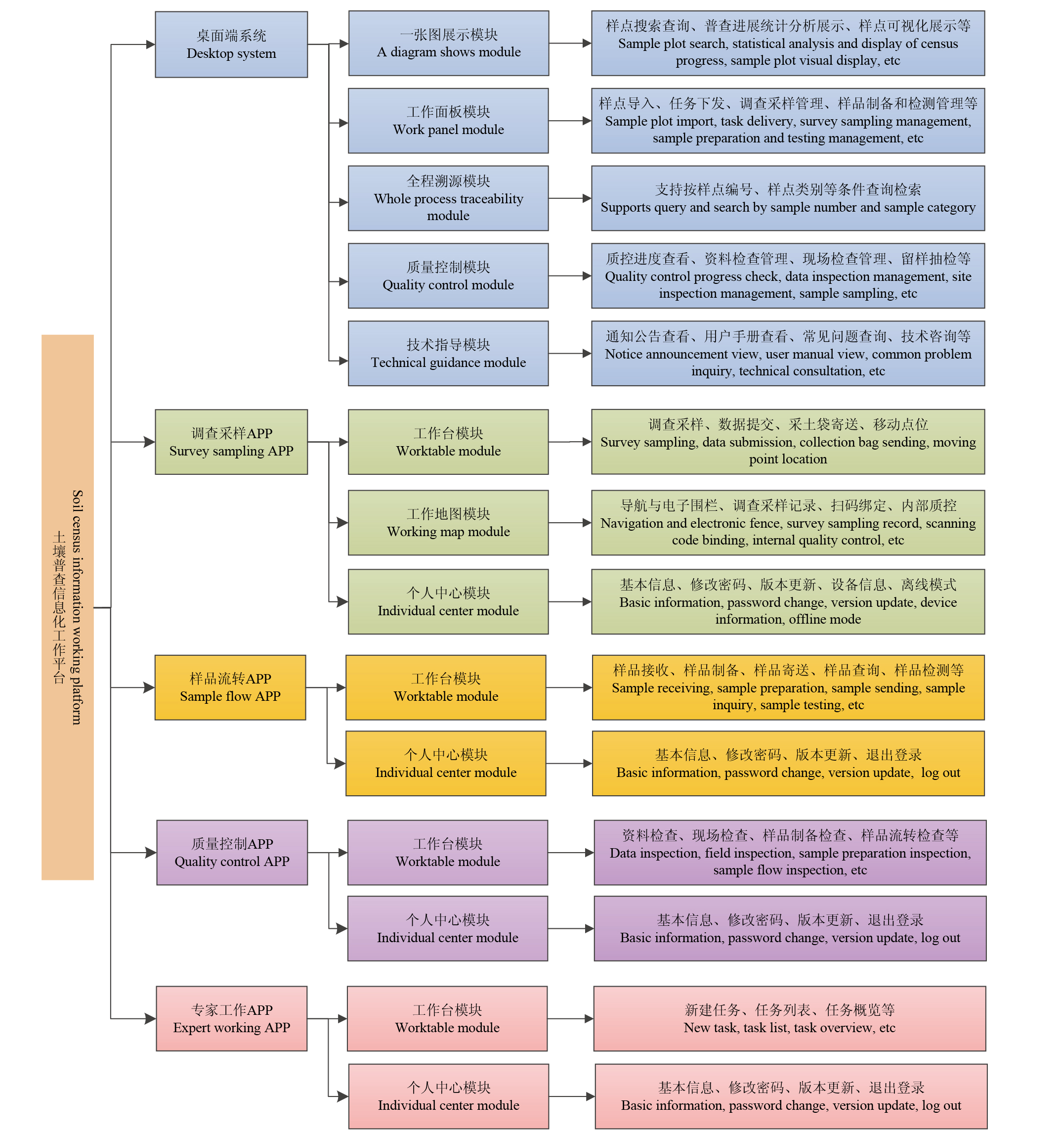
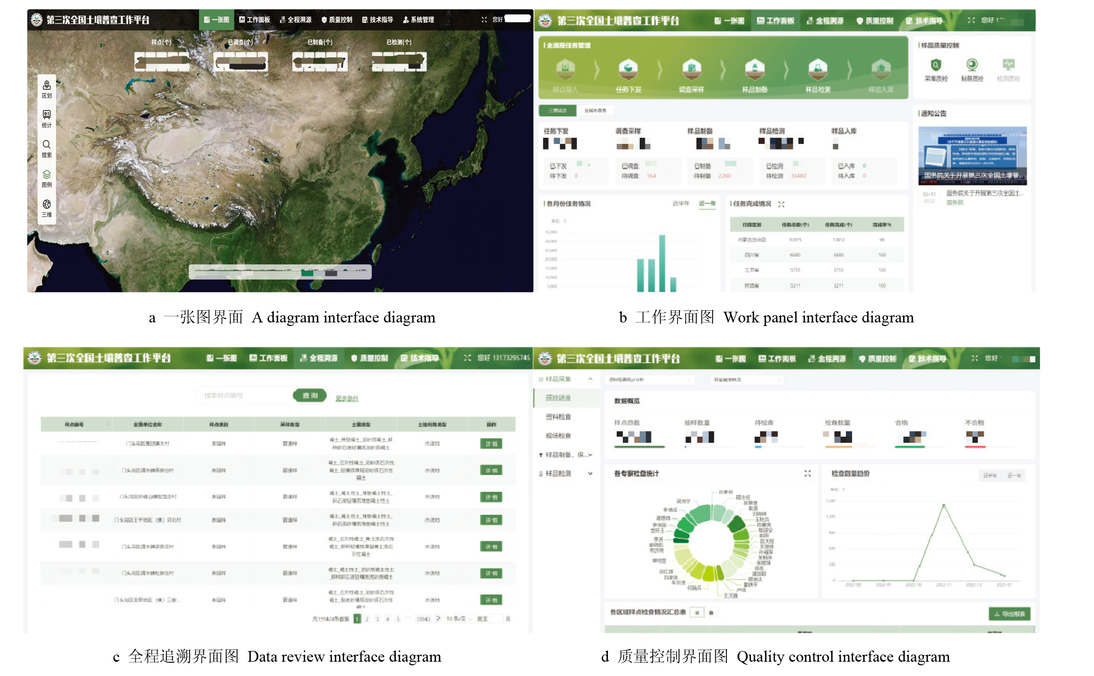
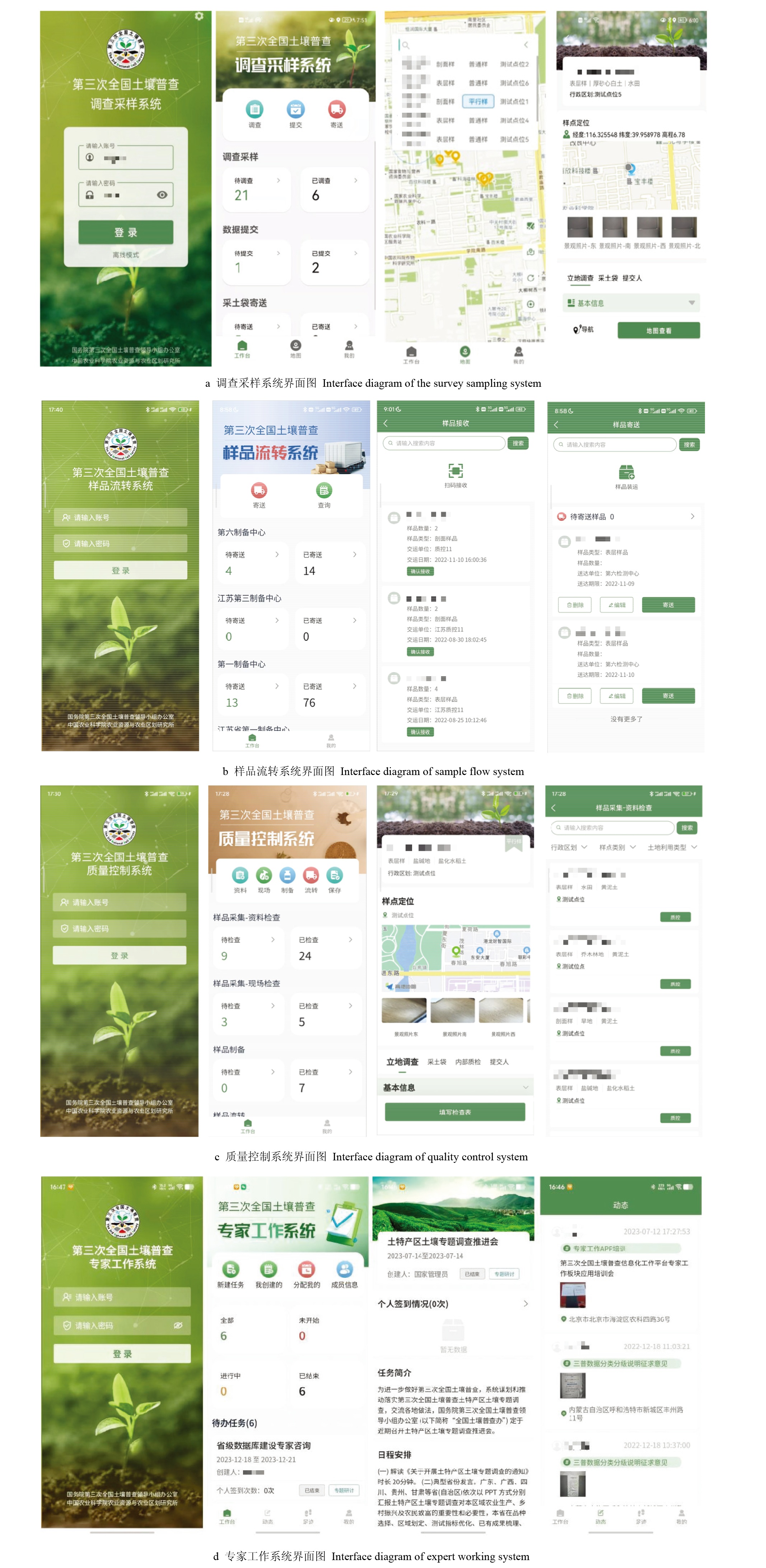
【Objective】Soil survey involves investigations on soil formation conditions, soil types, soil quality, soil utilization and its potential. Given their extensive scope, multi-departmental involvement, heavy workload, and high technical demands, enhancing work efficiency and ensuring data quality have become critical challenges in conducting soil surveys. Based on an in-depth analysis of the soil survey business, supported by information and digital technologies, and in combination with the third national soil census (hereinafter referred to as "the third soil survey"), this paper designed an information system for the third soil survey, developed an information work platform for the third soil survey, and realized the information recording, digital management and visual dispatching of the third soil survey work.【Method】According to the working characteristics of the soil survey, an information technology system composed of one desktop system and four mobile apps (investigation and sampling, sample transfer, quality control, and expert working) was designed, and an information work platform composed of four layers: infrastructure layer, data layer, platform layer, and user layer. In terms of technical implementation, the on-site limitation of sampling points was realized based on a virtual electronic fence, the intelligent comparison of detection data was realized based on threshold determination, and the dynamic sample data visualization was realized based on Cesium. In terms of platform functions, Java programming language and front-end and back-end separation technology were used to realize various functions. The desktop system realized a map of sample task management, sample preparation management, sample detection management, quality control, technical guidance, full traceability and other functional modules. The survey and sampling APP realized the functions of sample task change, sample point navigation, code scanning binding, data recording, offline data saving, and data submission. The sample flow APP realized the functions of sample flow progress query, sample receiving, sample packing, sample sending, sample receiving, sample testing, etc. The quality control APP realized the functions of investigation and sampling verification, sample preparation and inspection, test and laboratory flight inspection, on-site video recording, and inspection item comparison. The expert working APP realized the functions of task allocation, task execution, task check-in and viewing for various areas.【Result】Since the trial operation in June 2022, the platform process has been relatively clear, the functions have been relatively perfect, the reliability has been high, and the operation has been stable. Until the end of August, 2025, there were 81 000 registered users, 5.6 million visits, 400 million pieces of data collected and managed from various samples, a cumulative data volume of about 241TB, and an average response time within 2 s.【Conclusion】Designed and developed with support from geographic information systems, global positioning systems, intelligent workflows, microservices architecture, and other information and digital technologies, the soil survey information platform has effectively enhanced the efficiency of soil survey operations, reduced survey costs, and improved data quality. It has provided comprehensive, all-element information support for conducting the third soil survey.

Key words: soil survey, digital technology system, information work platform

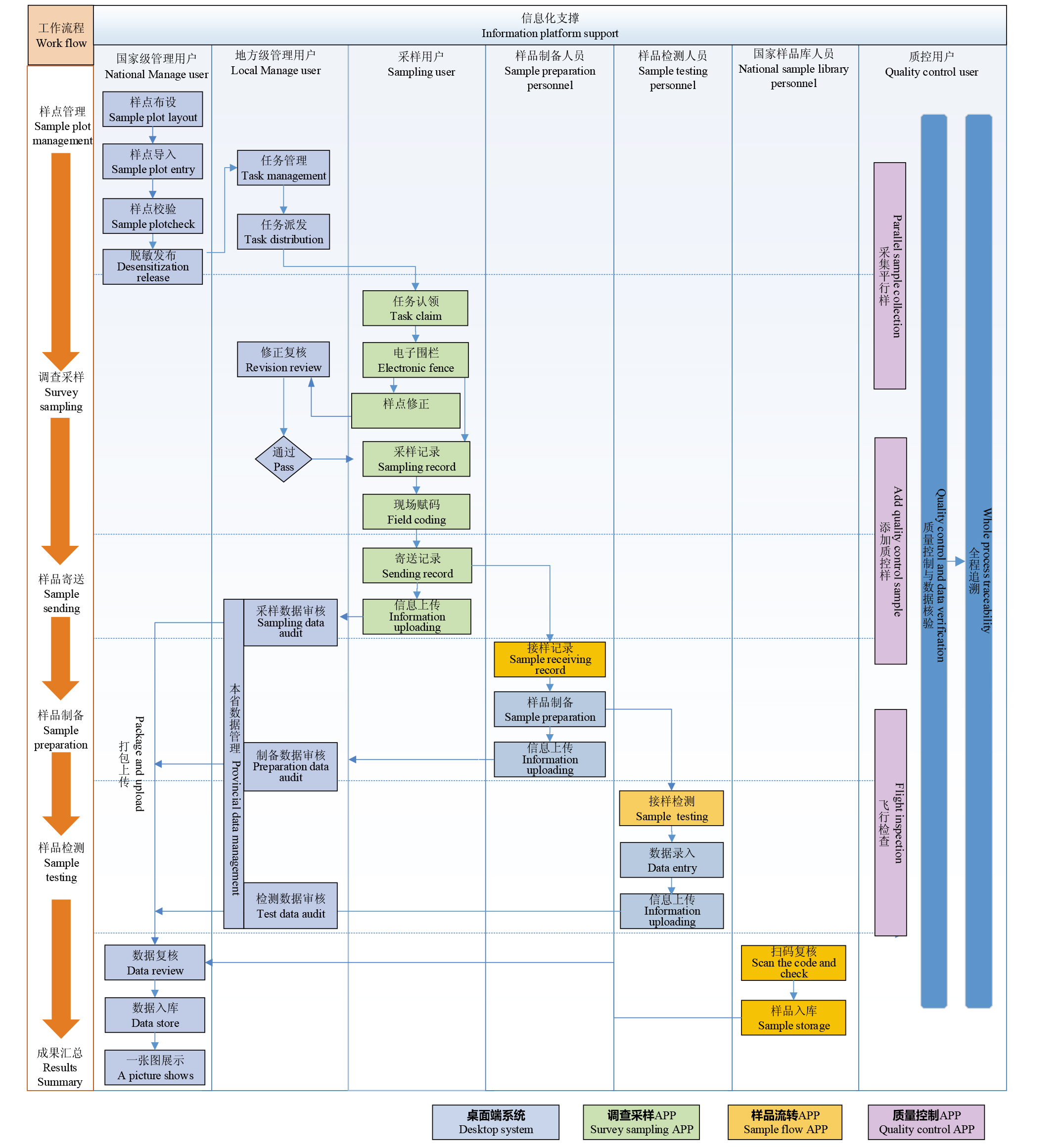
Fig. 1

Business flow chart of soil general investigation"

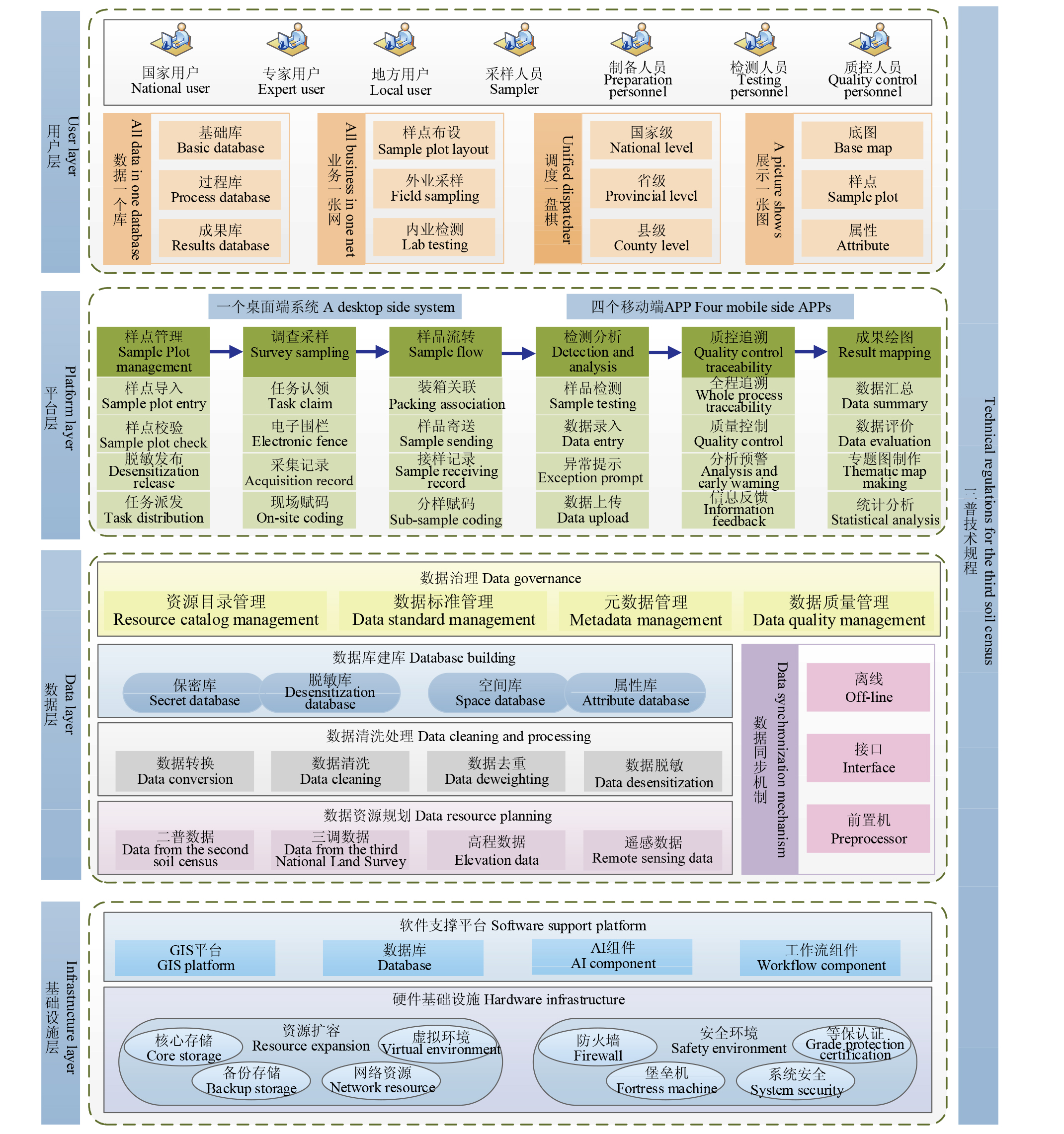
Fig. 2

Information technology framework of soil survey"

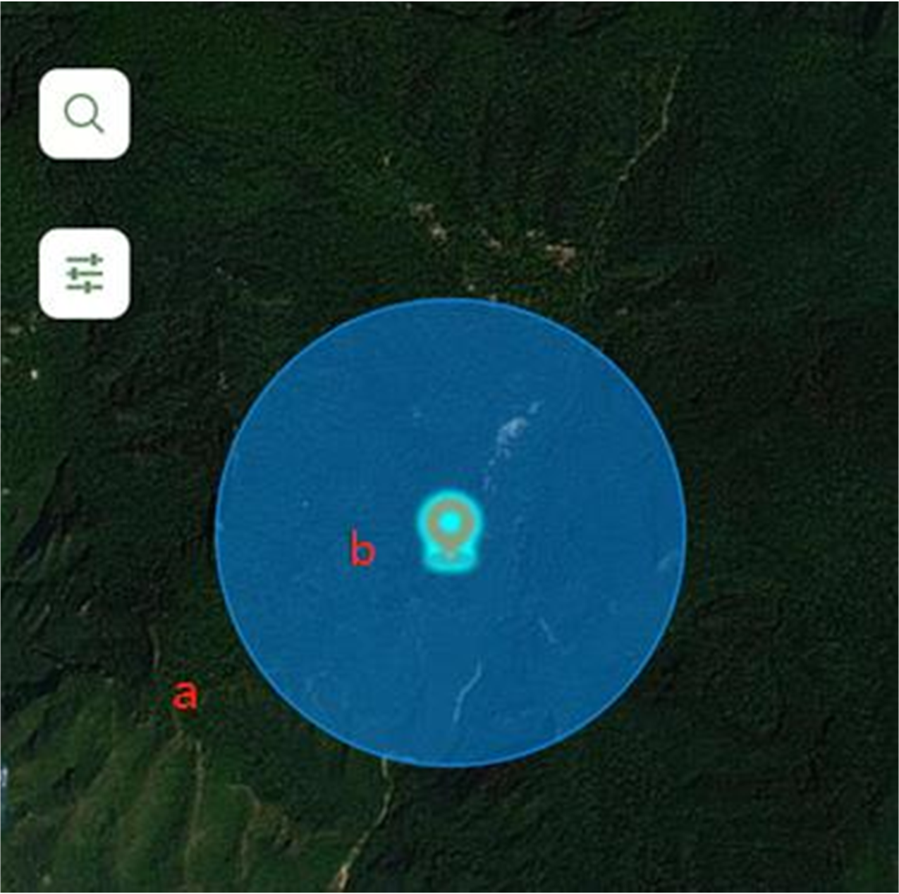
Fig. 3

Virtual electronic fence circular area"

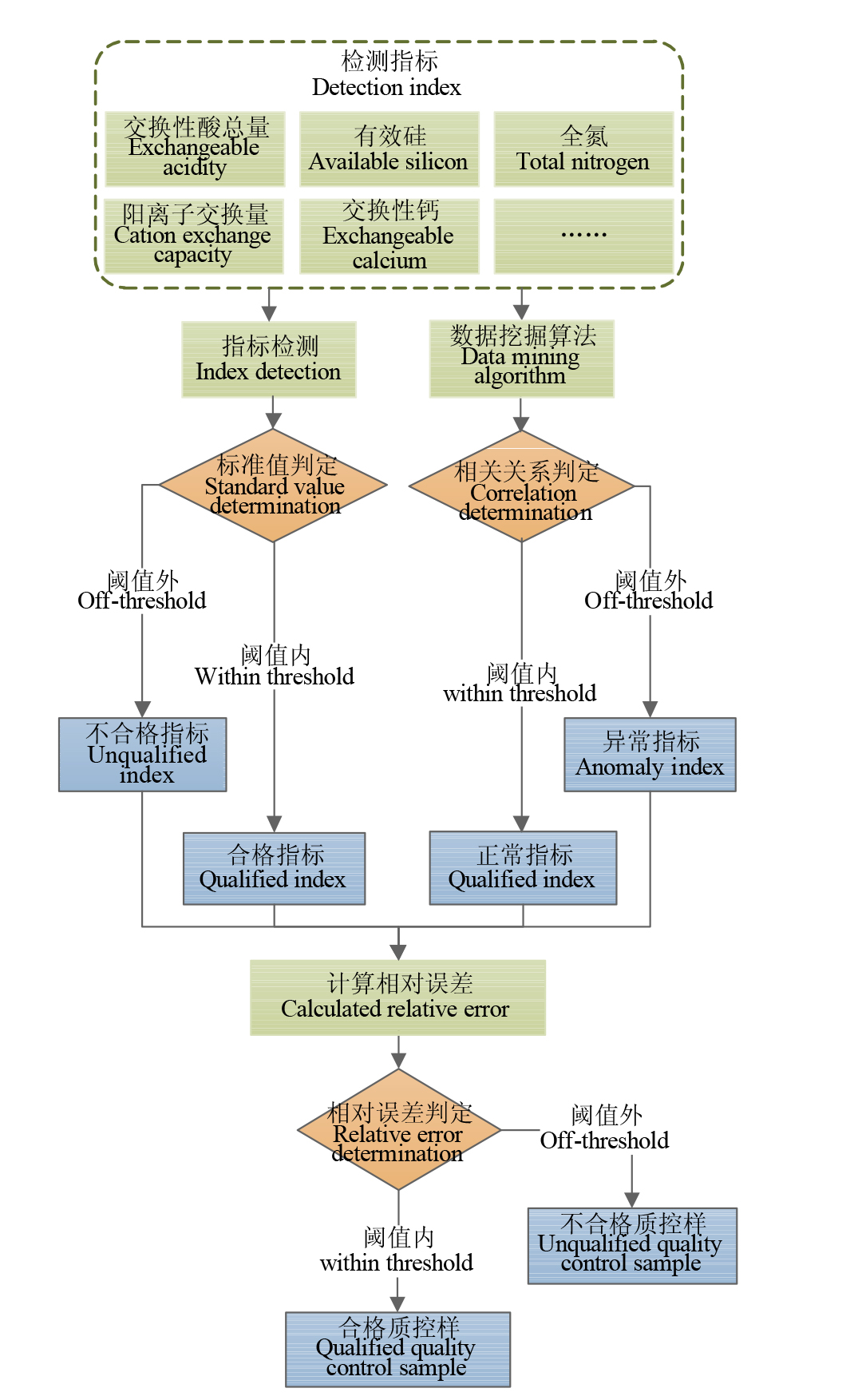
Fig. 4

Intelligent comparison of detection indicators"

Fig. 5

Visual display of sample information"

Table1

System development environment"

开发环境 Development environment 工具及版本号 Tool and version number
硬件Hardware Intel i7
操作系统 Operating system Windows 10
后端开发语言 Back-end deployment language OpenJDK 8
前端开发语言 Front-end development language Vue 3.0
开发工具 Development tools Android Studio, VisualStudio Code
后端开发框架 Back-end development framework SpringBoot 2.1.4+Mybatis 2.0.1
数据库 Database PostgreSQL14+Redis 4.0
代码托管工具 Code hosting tools Git

Fig. 6

The main function modules of the soil survey information platform"

Fig. 7

Desktop system interface of the soil survey information platform"

Fig. 8

Mobile application interface of the soil survey information platform"

Fig. 9

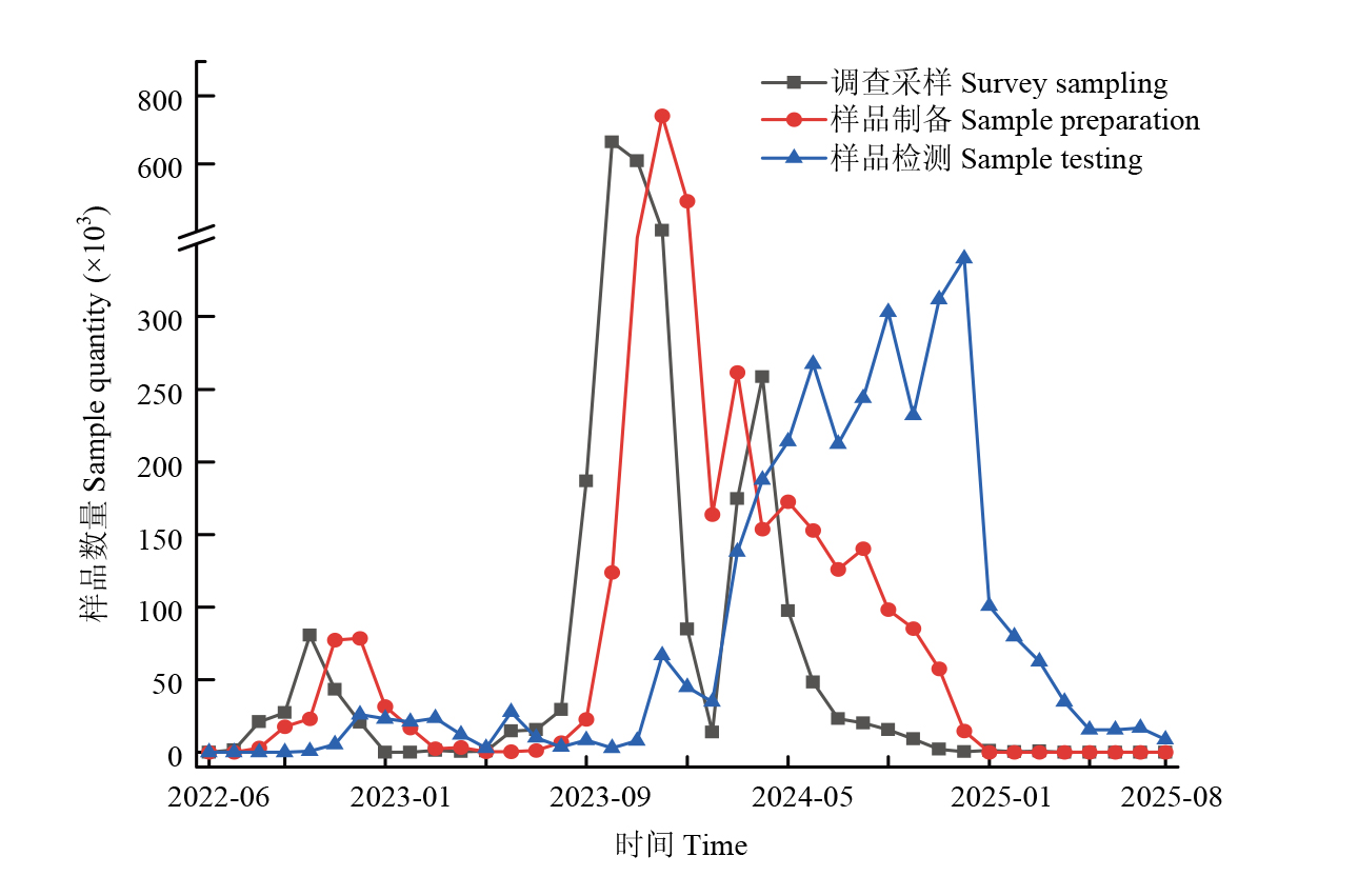
Task progress of the third soil survey of China from June 2022 to August 2025"

Fig. 10

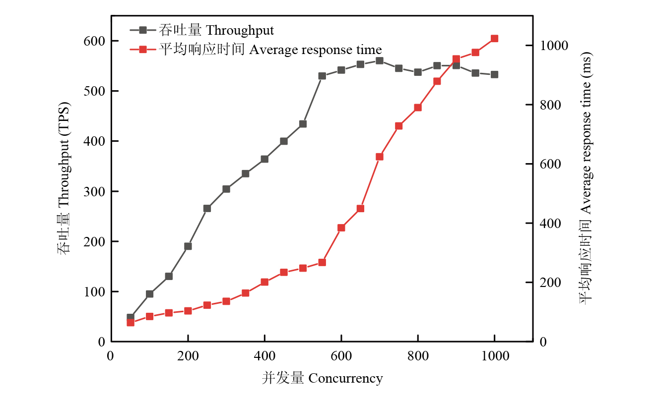
Performance test results of data transcoding requests on the soil survey information platform"

[1]
张维理, Kolbe H, 张认连, 张定祥, 白占国, 张晶, 师华定. 世界主要国家土壤调查工作回顾[J]. 中国农业科学, 2022, 55(18): 3565-3583. DOI: 10.3864/j.issn.0578-1752.2022.18.008.
Zhang W L, Kolbe H, Zhang R L, Zhang D X, Bai Z G, Zhang J, Shi H D. Overview of soil survey works in main countries of world[J]. Scientia Agricultura Sinica, 2022, 55(18): 3565-3583. DOI: 10.3864/j.issn.0578-1752.2022.18.008. (in Chinese)
[2]
龙怀玉, 卢昌艾, 冀宏杰, 张认连. 《第三次全国土壤普查暂行土壤分类系统》土类检索系统构建[J]. 中国农业科学, 2024, 57(21): 4264-4275. DOI: 10.3864/j.issn.0578-1752.2024.21.008.
Long H Y, Lu C A, Ji H J, Zhang R L. A retrieval system for great soil groups from China’s provisional soil classification system for the 3rd national soil census[J]. Scientia Agricultura Sinica, 2024, 57(21): 4264-4275. DOI: 10.3864/j.issn.0578-1752.2024.21.008. (in Chinese)
[3]
张维理, 傅伯杰, 徐爱国, 杨鹏, 陈涛, 张认连, 史舟, 吴文斌, 李建兵, 冀宏杰, 刘峰, 雷秋良, 李兆君, 冯瑶, 李艳丽, 徐用兵, 裴玮. 中国土壤调查结果的地统计特征[J]. 中国农业科学, 2022, 55(13): 2572-2583. DOI: 10.3864/j.issn.0578-1752.2022.13.008.
Zhang W L, Fu B J, Xu A G, Yang P, Chen T, Zhang R L, Shi Z, Wu W B, Li J B, Ji H J, Liu F, Lei Q L, Li Z J, Feng Y, Li Y L, Xu Y B, Pei W. Geostatistical characteristics of soil data from national soil survey works in China[J]. Scientia Agricultura Sinica, 2022, 55(13): 2572-2583. DOI: 10.3864/j.issn.0578-1752.2022.13.008. (in Chinese)
[4]
张杰, 王川, 董晓霞, 祝文琪, 岳慧丽, 刘升平, 周清波. 基于裂变模式的农业农村信息快速调查及分析平台开发与应用[J]. 中国农业科学, 2022, 55(21): 4158-4174. DOI: 10.3864/j.issn.0578-1752.2022.21.006.
Zhang J, Wang C, Dong X X, Zhu W Q, Yue H L, Liu S P, Zhou Q B. Development and application of rapid investigation and analysis platform for agricultural and rural information based on fission model[J]. Scientia Agricultura Sinica, 2022, 55(21): 4158-4174. DOI: 10.3864/j.issn.0578-1752.2022.21.006. (in Chinese)
[5]
Dumanski J, Kloosterman B, Brandon S E. Concepts, objectives and structure of the Canada soil information system[J]. Canadian Journal of Soil Science, 1975, 55(2): 181-187.
[6]
Lilburne L R, Hewitt A E, Webb T W. Soil and informatics science combine to develop S-map: A new generation soil information system for New Zealand[J]. Geoderma, 2012, 170: 232-238.
[7]
Post C J, Mikhailova E, Mcwhorter C M. Introductory soil science exercises using USDA web soil survey[J]. Journal of Natural Resources and Life Sciences Education, 2007, 36(1): 19-23.
[8]
Orgiazzi A, Ballabio C, Panagos P, Jones A, Fernández-Ugalde O. LUCAS soil, the largest expandable soil dataset for Europe: A review[J]. European Journal of Soil Science, 2018, 69(1): 140-153.
[9]
张甘霖, 龚子同, 骆国保, 张学雷. 国家土壤信息系统的结构、内容与应用[J]. 地理科学, 2001, 21(5): 401-406.
Zhang G L, Gong Z T, Luo G B, Zhang X L. Structure, contents and possible applications of China national soil information system[J]. Scientia Geographica Sinica, 2001, 21(5): 401-406. (in Chinese)

doi: 10.13249/j.cnki.sgs.2001.05.401
[10]
史学正, 于东升, 高鹏, 王洪杰, 孙维侠, 赵永存, 龚子同. 中国土壤信息系统(SISChina)及其应用基础研究[J]. 土壤, 2007, 39(3): 329-333.
Shi X Z, Yu D S, Gao P, Wang H J, Sun W X, Zhao Y C, Gong Z T. Soil information system of China (SISChina) and its application[J]. Soils, 2007, 39(3): 329-333. (in Chinese)
[11]
潘剑君, 靳婷婷, 孙维侠. 江西省余江县土壤信息系统建造研究[J]. 土壤学报, 1999, 36(4): 522-527.
Pan J J, Jin T T, Sun W X. A study on building up soil information system of Yujiang County, Jiangxi Province[J]. Acta Pedologica Sinica, 1999, 36(4): 522-527. (in Chinese)
[12]
潘剑君, 孙维侠, 靳婷婷. 土壤信息系统建造研究: 以江苏省大丰市为例[J]. 南京农业大学学报, 1999, 22(3): 45-48.
Pan J J, Sun W X, Jin T T. A study on building up soil information system of Dafeng City, Jiangsu Province[J]. Journal of Nanjing Agricultural University, 1999, 22(3): 45-48. (in Chinese)
[13]
贺红士, 侯彦林. 区域微机土壤信息系统的建立与应用[J]. 土壤学报, 1991, 28(4): 345-354.
He H S, Hou Y L. Development and application of soil information microcomputer system[J]. Acta Pedologica Sinica, 1991, 28(4): 345-354. (in Chinese)
[14]
刘忠, 李保国, 许敏, 高强. 基于开源Web-GIS的县域土壤信息系统设计[J]. 农业工程学报, 2014, 30(17): 175-182.
Liu Z, Li B G, Xu M, Gao Q. Design of county-level soil information system based on Web-GIS[J]. Transactions of the Chinese Society of Agricultural Engineering, 2014, 30(17): 175-182. (in Chinese)
[15]
刘京, 常庆瑞, 刘淼, 岳庆玲. 陕西省土壤信息系统的设计与建立[J]. 西北农林科技大学学报(自然科学版), 2007, 35(12): 129-132.
Liu J, Chang Q R, Liu M, Yue Q L. Study on building soil information system of Shaanxi Province[J]. Journal of Northwest A&F University (Natural Science Edition), 2007, 35(12): 129-132. (in Chinese)
[16]
邵作宇, 常庆瑞, 陶文芳. 基于ArcEngine的陕西省土壤信息系统构建[J]. 水土保持通报, 2009, 29(4): 125-129.
Shao Z Y, Chang Q R, Tao W F. Establishment of Shaanxi soil information system based on ArcEngine[J]. Bulletin of Soil and Water Conservation, 2009, 29(4): 125-129. (in Chinese)
[17]
赵明松, 程先富, 王世航, 谢勇. 安徽省土壤信息系统(AHSIS)的设计与开发[J]. 中国农学通报, 2008, 24(2): 441-444.
Zhao M S, Cheng X F, Wang S H, Xie Y. The design and development of Anhui Province soil information system[J]. Chinese Agricultural Science Bulletin, 2008, 24(2): 441-444. (in Chinese)
[18]
生态环境部. 全国土壤环境信息平台上线启动[J]. 工业水处理, 2019, 39(2): 108.
Ministry of Ecology and Environment. The national soil environment information platform was launched[J]. Industrial Water Treatment, 2019, 39(2): 108. (in Chinese)
[19]
国务院第三次全国土壤普查领导小组办公室. 第三次全国土壤普查技术规程规范(修订版)[Z]. 2023.
State Council’s Office for the 3rd National Soil Census. Technical specifications and guidelines for the 3rd National Soil Census (Revised edition)[Z]. 2023. (in Chinese)
[20]
杨民安, 孙雨, 王凤超, 杨晶, 陈进. 基于人工智能的小麦高效育种信息交互系统构建[J]. 农业工程学报, 2024, 40(13): 117-123.
Yang M A, Sun Y, Wang F C, Yang J, Chen J. Construction of an efficient wheat breeding information exchange system based on artificial intelligence[J]. Transactions of the Chinese Society of Agricultural Engineering, 2024, 40(13): 117-123. (in Chinese)
[21]
姚艳, 牛明雷, 孙法军, 姚京婵, 常晓燕. 基于微服务架构的农业转移支付项目管理系统设计与实现[J]. 中国农业科学, 2021, 54(15): 3207-3218. DOI: 10.3864/j.issn.0578-1752.2021.15.006.
Yao Y, Niu M L, Sun F J, Yao J C, Chang X Y. Design and implementation of agricultural transfer payment project management system based on micro-service architecture[J]. Scientia Agricultura Sinica, 2021, 54(15): 3207-3218. DOI: 10.3864/j.issn.0578-1752.2021.15.006. (in Chinese)
[22]
苏杭. 电子围栏技术在景区交通问题中应用的SWOT分析[J]. 物流工程与管理, 2019, 41(9): 124-126.
Su H. SWOT analysis of the application of electronic fence in the scenic spots traffic problems[J]. Logistics Engineering and Management, 2019, 41(9): 124-126. (in Chinese)
[23]
尹雄, 寇卫利, 陈岳, 张雨果, 袁华. 基于智慧牧场的虚拟电子围栏关键技术及应用[J]. 黑龙江畜牧兽医, 2022(8): 9-12, 18.
Yin X, Kou W L, Chen Y, Zhang Y G, Yuan H. Key technology and application of virtual electronic fencing for livestock based on smart pasture[J]. Heilongjiang Animal Science and Veterinary Medicine, 2022(8): 9-12, 18. (in Chinese)
[24]
雷建容, 莫太相, 李孝东, 张庆玉, 张冀, 田丽, 杨玉敏, 唐莲. 川中丘陵区土壤有机质与全氮关系研究[J]. 西南农业学报, 2013, 26(2): 663-666.
Lei J R, Mo T X, Li X D, Zhang Q Y, Zhang J, Tian L, Yang Y M, Tang L. Relationships between soil organic matter and total nitrogen in central hilly area of Sichuan[J]. Southwest China Journal of Agricultural Sciences, 2013, 26(2): 663-666. (in Chinese)
[25]
崔帅, 刘烁然, 王寅, 夏晨真, 焉莉, 冯国忠, 高强. 吉林省旱地土壤有效硫含量及其与土壤有机质和全氮的关系[J]. 中国农业科学, 2022, 55(12): 2372-2383. DOI: 10.3864/j.issn.0578-1752.2022.12.009.
Cui S, Liu S R, Wang Y, Xia C Z, Yan L, Feng G Z, Gao Q. Soil available sulfur content in Jilin Province and its correlation with soil organic matter and soil total nitrogen[J]. Scientia Agricultura Sinica, 2022, 55(12): 2372-2383. DOI: 10.3864/j.issn.0578-1752.2022.12.009. (in Chinese)
[26]
范俊甫, 胡桃英, 何惠馨, 秦柳, 李桂华. Cesium框架多源电子地图瓦片数据混搭方案设计[J]. 遥感学报, 2019, 23(4): 695-705.
Fan J F, Hu T Y, He H X, Qin L, Li G H. Multi-source digital map tile data mashup scheme design based on Cesium[J]. National Remote Sensing Bulletin, 2019, 23(4): 695-705. (in Chinese)
[27]
Hunter J, Brooking C, Reading L, Vink S. A Web-based system enabling the integration, analysis, and 3D sub-surface visualization of groundwater monitoring data and geological models[J]. International Journal of Digital Earth, 2016, 9(2): 197-214.
[28]
University O D, De Paor D G, Whitmeyer S J, Bentley C. Cesium: A virtual globe with strong potential applications in geoscience education[C]. Geological Society of America Abstracts with Programs, 2016.
[29]
Batjes N H, Ribeiro E, van Oostrum A. Standardised soil profile data to support global mapping and modelling (WoSIS snapshot 2019)[J]. Earth System Science Data, 2020, 12(1): 299-320.

doi: 10.5194/essd-12-299-2020
[30]
Tóth G, Weynants M, van Liedekerke M, Panagos P, Montanarella L. Soil databases in support of pan-European soil water model development and applications[J]. Procedia Environmental Sciences, 2013, 19: 411-415.
[1] WeiLi ZHANG,H KOLBE,RenLian ZHANG,DingXiang ZHANG,ZhanGuo BAI,Jing ZHANG,HuaDing SHI. Overview of Soil Survey Works in Main Countries of World [J]. Scientia Agricultura Sinica, 2022, 55(18): 3565-3583.
[2] ZHANG WeiLi, FU BoJie, XU AiGuo, YANG Peng, CHEN Tao, ZHANG RenLian, SHI Zhou, WU WenBin, LI JianBing, JI HongJie, LIU Feng, LEI QiuLiang, LI ZhaoJun, FENG Yao, LI YanLi, XU YongBing, PEI Wei. Geostatistical Characteristics of Soil Data from National Soil Survey Works in China [J]. Scientia Agricultura Sinica, 2022, 55(13): 2572-2583.
[3] YAN Li, WANG Yin, FENG Guo-zhong, GAO Qiang. Status and Change Characteristics of Farmland Soil Fertility in Jilin Province [J]. Scientia Agricultura Sinica, 2015, 48(23): 4800-4810.
[4] ZHANG Wei-Li, XU Ai-Guo, ZHANG Ren-Lian, JI Hong-Jie. Review of Soil Classification and Revision of China Soil Classification System [J]. Scientia Agricultura Sinica, 2014, 47(16): 3214-3230.
Viewed
Full text


Abstract

Cited

  Shared   
  Discussed   
No Suggested Reading articles found!