


中国农业科学 ›› 2025, Vol. 58 ›› Issue (20): 4070-4084.doi: 10.3864/j.issn.0578-1752.2025.20.004
所属专题: 专刊——盐碱地智慧监测与生态化利用
雷鸣阔1,2,3( ), 查燕2,3, 王丽2, 程钢1, 温彩运2, 尹作堂2, 陆苗2,3()
收稿日期:2025-07-22
接受日期:2025-09-29
出版日期:2025-10-16
发布日期:2025-10-14
通信作者:
联系方式:
雷鸣阔,E-mail:212304020041@home.hpu.edu.cn。
基金资助:
LEI MingKuo1,2,3(), ZHA Yan2,3, WANG Li2, CHENG Gang1, WEN CaiYun2, YIN ZuoTang2, LU Miao2,3()
Received:2025-07-22
Accepted:2025-09-29
Published:2025-10-16
Online:2025-10-14
摘要:
【背景】土壤盐渍化严重制约作物生长和生态平衡,精准监测对盐碱地改良利用、产量预测及农田管理至关重要。在自然和人为等多种因素影响下,土壤盐渍化主要受水分和盐分在土体中迁移与再分配的水盐运动过程控制,呈现垂直迁移显著、空间异质性大的特点。目前无人机遥感技术已经广泛用于田块尺度的土壤盐渍化监测,但是,遥感技术多进行表层监测,难以表征深层盐分梯度。【目的】融合机器学习与克里金插值方法,建立无人机影像分层建模的土壤深层盐渍化空间预测方法。【方法】首先,利用无人机搭载多光谱传感器获取试验田高分辨率影像,并同步测量不同深度土壤盐分数据,辅以实时动态差分定位技术确保空间精度;随后,构建包含红边波段在内的光谱特征集,并基于随机森林算法进行特征优选;在此基础上,融合机器学习与克里金插值方法,建立分层土壤盐分预测模型,生成高分辨率盐分分布图;最后,通过与三次拟合深度函数预测方法对比验证本方法在深层盐渍化空间表征中的优势。【结果】混合模型分层建模的土壤深层盐渍化空间预测各深度预测精度R2分别为0.68(0—10 cm)、0.51(10—20 cm)、0.58(20—40 cm)、0.56(40—60 cm)与0.52(60—80 cm),其中0—10 cm表层预测效果最佳。红边盐分指数在各深度均表现为重要预测因子,验证了所构建红边指数的适用性与有效性。通过混合模型与三次拟合深度函数预测的结果对比,混合模型分层建模的土壤深层盐渍化空间预测精度更高,更能真实地反映试验区不同深度的盐渍化程度。【结论】无人机遥感技术在浅层(0—10 cm)土壤盐分预测最优,土壤性质的预测精度随深度的增加而下降,深层精度仍需提升;从预测结果来看,随着深度增加,土壤盐分均值逐渐升高,表明盐分在土壤剖面中存在累积现象;相较于三次拟合深度函数方法,本研究提出的基于随机森林分层建模与克里金残差校正的混合模型在各土层展现出更高的空间预测精度,更具合理性与实用性,为区域土壤盐渍化动态监测及分层盐分精准制图提供了科学依据。
雷鸣阔, 查燕, 王丽, 程钢, 温彩运, 尹作堂, 陆苗. 基于无人机影像分层建模的土壤深层盐渍化空间预测[J]. 中国农业科学, 2025, 58(20): 4070-4084.
LEI MingKuo, ZHA Yan, WANG Li, CHENG Gang, WEN CaiYun, YIN ZuoTang, LU Miao. Spatial Prediction of Deep Soil Salinization Based on Layered Modeling Using UAV Imagery[J]. Scientia Agricultura Sinica, 2025, 58(20): 4070-4084.

图1
研究区示意图"

图2
研究技术流程图"
表1
指数特征计算公式"
| 数据Data | 特征Feature | 简称Abbreviation | 计算公式Calculation formula |
|---|---|---|---|
| 光谱值 Spectral value | 绿波段Green band | G | — |
| 红波段Red band | R | — | |
| 红边Red edge | REG | — | |
| 近红外Near-infrared | NIR | — | |
| 盐度指数 Salinity index | 盐度指数Salinity index | SI | (R×NIR)/G[ |
| 盐度红边指数Salinity red-edged index | SIREG | (REG×NIR)/G | |
| 归一化盐度指数Normalized salinity index | NDSI | (R-NIR)/(R+NIR)[ | |
| 归一化盐度红边指数 Normalized salinity red-edged index | NDSIREG | (REG-NIR)/(REG+NIR) | |
| 盐度指数1 Salinity index 1 | SI1 | $ \sqrt{G \times R}$ [ | |
| 盐度红边指数1 Salinity index red-edged 1 | SI1REG | $ \sqrt{G \times R E G}$ | |
| 盐度指数2 Salinity index 2 | SI2 | $ \sqrt{G^{2}+R^{2}+N I R^{2}}$ [ | |
| 盐度红边指数2 Salinity index red-edged 2 | SI2REG | $ \sqrt{G^{2}+R E G^{2}+N I R^{2}}$ | |
| 盐度指数3 Salinity index 3 | SI3 | $ \sqrt{G^{2}+R^{2}}$ [ | |
| 盐度红边指数3 Salinity index red-edged 3 | SI3REG | $ \sqrt{G^{2}+R E G^{2}}$ | |
| 土壤指数T Soil index T | SIT | 100(R-NIR)[ | |
| 红边土壤指数T Red-edged soil index T | SITREG | 100(REG-NIR) | |
| 强度指数 Intensity index | 强度指数1 Intensity index 1 | Int1 | (G+R)/2[ |
| 强度红边指数1 Intensity red-edged index 1 | Int1REG | (G+REG)/2 | |
| 强度指数2 Intensity index 2 | Int2 | (G+R+NIR)/2[ | |
| 强度红边指数2 Intensity red-edged index 2 | Int2REG | (G+REG+NIR)/2 | |
| 植被指数 Vegetation index | 归一化植被指数 Normalized difference vegetation index | NDVI | $ \frac{N I R-R}{N I R+R}$ [ |
| 归一化植被红边指数 Normalized difference vegetation red-edged index | NDVIREG | $ \frac{N I R-R E G}{N I R+R E G}$ | |
| 土壤调节植被指数 Soil adjusted vegetation index | SAVI | $ \frac{(1+L) \times(N I R-R)}{N I R+R+L}$[ | |
| 红边土壤调节植被指数 Soil adjusted vegetation red-edged index | SAVIREG | $ \frac{(1+L) \times(N I R-R E G)}{N I R+R E G+L}$ | |
| 亮度指数Brightness index | BI | $ \sqrt{R^{2}+N I R^{2}}$ [ | |
| 红边高度指数Brightness red-edged index | BIREG | $ \sqrt{R E G^{2}+N I R^{2}}$ | |
| 氧化铁指数 Iron oxide index | IFe2O3 | $ \frac{R}{N I R}$ [ | |
| 红边氧化铁指数 Iron oxide red-edged index | IFe2O3REG | $ \frac{R E G}{N I R}$ | |
| 差异植被指数Differential vegetation index | DVI | NIR-R[ | |
| 红边差异植被指数 Differential vegetation red-edged index | DVIREG | NIR-REG |
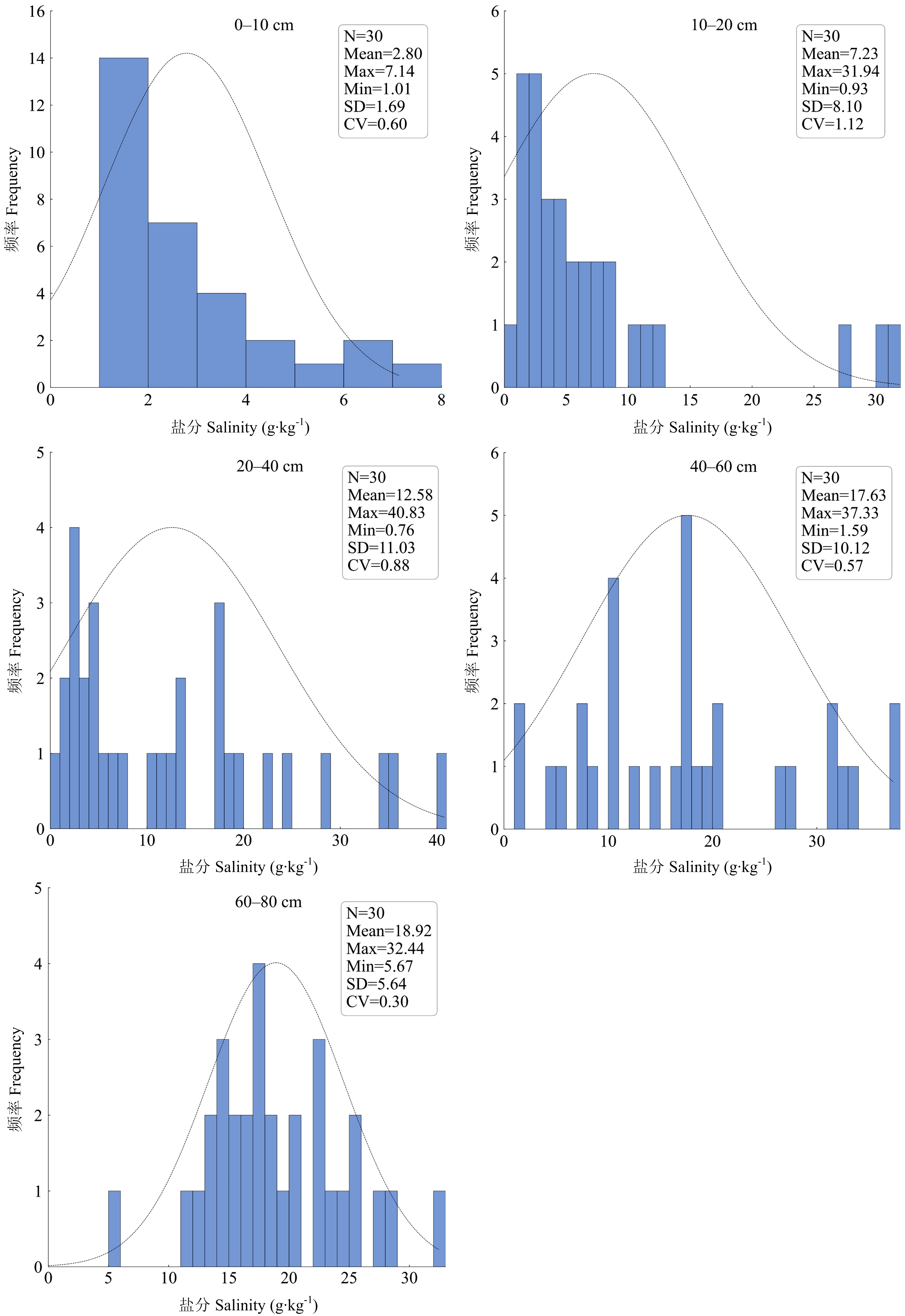
图3
实验室样本分析直方图"

图4
各层重要特征筛选"

图5
分层土壤盐分预测"
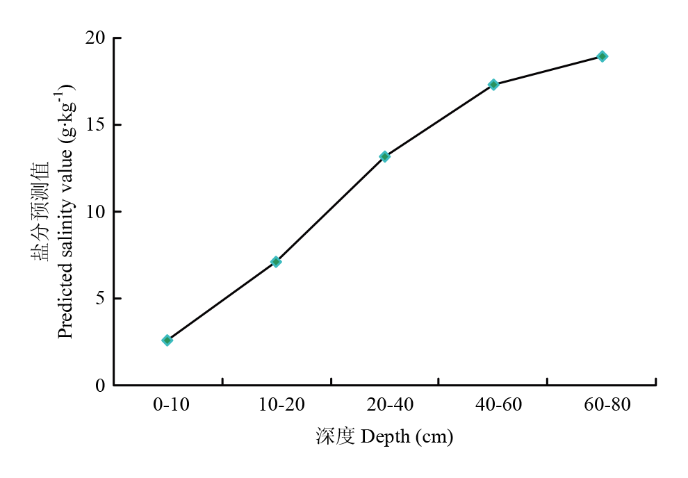
图6
剖面预测均值"
表2
混合模型预测精度"
| 深度 Depth (cm) | 测试集Test set | 验证集Validation set | ||||
|---|---|---|---|---|---|---|
| R2 | RMSE | MAE | R2 | RMSE | MAE | |
| 0-10 | 0.73 | 0.77 | 0.51 | 0.68 | 0.93 | 0.69 |
| 10-20 | 0.71 | 1.74 | 1.41 | 0.51 | 2.25 | 2.12 |
| 20-40 | 0.78 | 4.87 | 3.93 | 0.58 | 4.37 | 3.68 |
| 40-60 | 0.74 | 4.46 | 3.32 | 0.56 | 4.44 | 3.56 |
| 60-80 | 0.69 | 3.05 | 2.55 | 0.52 | 4.81 | 3.46 |

图7
三次拟合深度函数结果"
表3
三次拟合深度函数预测精度"
| 深度Depth (cm) | 三次拟合公式Cubic fitting formula (y=) | R2 | F检验(P值)F-test (P value) |
|---|---|---|---|
| 10-20 | 0.7722x3-9.3995x2+33.548x-25.728 | 0.22 | 0.12 |
| 20-40 | 0.9934x3-11.766x2+40.284x-25.292 | 0.26 | 0.09 |
| 40-60 | 0.1979x3-2.0289x2+6.9204x+9.7859 | 0.27 | 0.07 |
| 60-80 | -0.118x3+2.0183x2-8.4252x+26.231 | 0.26 | 0.08 |
| [1] |
李红强, 姚荣江, 杨劲松, 王相平, 谢文萍, 张新. 滨海盐渍农田土壤硝化势特征及其影响因素. 应用生态学报, 2022, 33(8): 2205-2212.
doi: 10.13287/j.1001-9332.202208.017 |
|
|
|
| [2] |
王辉, 高玉录, 于梦, 杜远鹏, 孙永江, 翟衡. 根灌乙酸及葡萄酒对海水胁迫下葡萄光抑制的影响. 中国农业科学, 2018, 51(21): 4210-4218. doi: 10.3864/j.issn.0578-1752.2018.21.019.
|
|
|
|
| [3] |
|
| [4] |
宋岩, 柴明堂, 李王成, 孙利英, 吾连恩·赛尔奴, 杜天择, 基于RGB和纹理特征的土壤表层水盐信息反演方法. 中国农业科学, 2025, 58(6): 1159-1172. doi: 10.3864/j.issn.0578-1752.2025.06.009.
|
|
|
|
| [5] |
张靖康, 宋乃平, 杨霜奇, 王兴, 陈林, 王启学. 荒漠草原土壤盐分空间变异特征研究. 土壤通报, 2025, 56(1): 87-95.
|
|
|
|
| [6] |
|
| [7] |
冯春晖, 刘新路, 纪文君, 吴家林, 柳维扬, 彭杰. 基于电磁感应技术的棉田土壤电导率时空异质性研究. 土壤学报, 2022, 59(4): 999-1011.
|
|
|
|
| [8] |
罗德芳, 冯春晖, 吴家林, 殷彩云, 柳维扬, 彭杰. 基于电磁感应协同野外原位光谱的土壤盐分反演研究. 中国土壤与肥料, 2020(6): 107-113.
|
|
|
|
| [9] |
杨劲松, 姚荣江, 王相平, 谢文萍. 河套平原盐碱地生态治理和生态产业发展模式. 生态学报, 2016, 36(22): 7059-7063.
|
|
|
|
| [10] |
|
| [11] |
朱阿兴, 杨琳, 樊乃卿, 曾灿英, 张甘霖. 数字土壤制图研究综述与展望. 地理科学进展, 2018, 37(1): 66-78.
doi: 10.18306/dlkxjz.2018.01.008 |
|
doi: 10.18306/dlkxjz.2018.01.008 |
|
| [12] |
张甘霖, 朱阿兴, 史舟, 王秋兵, 刘宝元, 张兴昌, 史志华, 杨金玲, 刘峰, 宋效东, 吴华勇, 曾荣. 土壤地理学的进展与展望. 地理科学进展, 2018, 37(1): 57-65.
doi: 10.18306/dlkxjz.2018.01.007 |
|
doi: 10.18306/dlkxjz.2018.01.007 |
|
| [13] |
赵彦锋, 李怡欣, 马盼盼, 陈杰, 李元元, 杨琼, 程道全. 近30年河南省耕地土壤有机碳的三维变化与关键因素研究. 土壤学报, 2023, 60(5): 1409-1420.
|
|
|
|
| [14] |
|
| [15] |
|
| [16] |
解宪丽, 夏成业, 殷彪, 李安波, 李开丽, 潘贤章. 三维空间土壤推测与土壤模型构建研究进展. 土壤学报, 2025, 62(1): 14-28.
|
|
|
|
| [17] |
doi: 10.1016/B978-0-12-800137-0.00003-0 |
| [18] |
doi: 10.1016/j.scib.2021.10.013 pmid: 36546081 |
| [19] |
|
| [20] |
韩文霆, 崔家伟, 崔欣, 马伟童, 李广. 基于特征优选与机器学习的农田土壤含盐量估算研究. 农业机械学报, 2023, 54(3): 328-337.
|
|
|
|
| [21] |
马增辉, 马钢. 陕西卤泊滩“改排为蓄”条件下深层土壤盐分空间格局研究. 安徽农业科学, 2018, 46(35): 117-119.
|
|
|
|
| [22] |
姜彬, 闫板瑞, 李家鑫, 刘蓉. 黄河中游渭北卤泊滩地区盐碱地土壤肥力综合评价及分析. 西北大学学报(自然科学版), 2022, 52(3): 371-379.
|
|
|
|
| [23] |
|
| [24] |
闫瑜涛, 胡海飞, 王海涛. 卤泊滩盐碱地如何掀起“金色革命”. 农业科技报, (2025-04-30) [2025-07-22].
|
|
|
|
| [25] |
|
| [26] |
罗冰, 陈丹丹. 质量法在土壤水溶性盐总量测定中的应用. 化工设计通讯, 2023, 49(6): 176-178.
|
|
|
|
| [27] |
|
| [28] |
|
| [29] |
|
| [30] |
|
| [31] |
|
| [32] |
|
| [33] |
|
| [34] |
|
| [35] |
胡丹桂, 舒红. 基于协同克里金空气湿度空间插值研究. 湖北农业科学, 2014, 53(9): 2045-2049.
|
|
|
|
| [36] |
|
| [37] |
张自豪, 王国强, 薛宝林, 阿膺兰, 张晓婧, 王立波. 基于深度学习方法预测缺资料区域深层土壤水分. 水利水电技术, 2022, 53(11): 25-36.
|
|
|
|
| [38] |
|
| [39] |
|
| [40] |
|
| [41] |
|
| [42] |
|
| [43] |
|
| [44] |
|
| [45] |
|
| [46] |
|
| [47] |
|
| [48] |
杨菲菲, 张王菲, 赵磊, 赵含, 姬永杰, 王梦金. 基于GF-1数据的二阶段遥感特征优选与森林地上生物量反演模型. 林业科学, 2025, 61(4): 9-19.
|
|
|
| [1] | 王冰洁, 秦诗涵, 李德成, 胡文友, 姜军, 迟凤琴, 张超, 张久明, 徐英德, 汪景宽. 黑龙江省嫩江市土壤容重空间分布格局及传递函数构建[J]. 中国农业科学, 2025, 58(9): 1791-1803. |
| [2] | 吴欣珈, 薛玮, 严翊丹, 聂莹莹, 叶立明, 徐丽君. 呼伦贝尔土壤有机碳时空变异特征及其影响因素[J]. 中国农业科学, 2025, 58(6): 1145-1158. |
| [3] | 张帆, 唐湘方, 杨亮, 王辉, 陈睿鹏, 熊本海. 肉牛生产性能智能监测技术研究进展[J]. 中国农业科学, 2025, 58(23): 5081-5096. |
| [4] | 高奇奇, 韩哲群, 张海睿, 南珊珊, 黄炎炎, 朱恒侠, 武雪萍. 引黄灌区次生盐渍化对土壤质量与耕地产能的影响[J]. 中国农业科学, 2025, 58(20): 4272-4284. |
| [5] | 邵明超, 安敬威, 刘博睿, 吴建双, 张琪, 姚霞, 程涛, 江冲亚, 曹卫星, 郑恒彪, 朱艳. 基于多模态数据的小麦苗情综合评估研究[J]. 中国农业科学, 2025, 58(19): 3857-3871. |
| [6] | 李艾雯, 成金礼, 陈丹, 陈鑫怡, 毛雅若, 李启权. 基于数据填补的四川盆地耕地表层土壤无机碳时空变化特征[J]. 中国农业科学, 2025, 58(14): 2838-2853. |
| [7] | 冯晓琳, 张楚天, 许晨阳, 耿增超, 胡斐南, 杜伟. 陕西省土壤无机碳的时空分布特征及影响因素[J]. 中国农业科学, 2024, 57(8): 1517-1532. |
| [8] | 张建龙, 邢文文, 叶绍波, 张超, 郑德聪. 基于双输出回归卷积神经网络的燕麦株高估测研究[J]. 中国农业科学, 2024, 57(20): 3974-3985. |
| [9] | 童婉婷, 魏浩东, 杨靖雅, 金文捷, 宋茜, 胡琼, 尹高飞, 徐保东. 多源中高分辨率影像协同下时间合成窗口对农作物识别的影响[J]. 中国农业科学, 2024, 57(2): 250-263. |
| [10] | 王赟赟, 李毅念, 陈玉仑, 丁启朔, 何瑞银. 基于改进Mask R-CNN的小麦在穗籽粒表型参数测试方法[J]. 中国农业科学, 2024, 57(12): 2322-2335. |
| [11] | 苏琦, 汤亚飞, 佘小漫, 蓝国兵, 于琳, 吴正伟, 李正刚, 何自福. 广东省蒲瓜病毒种类鉴定及多重RT-PCR检测方法的建立[J]. 中国农业科学, 2023, 56(23): 4684-4695. |
| [12] | 李棉燕, 王立贤, 赵福平. 机器学习在动物基因组选择中的研究进展[J]. 中国农业科学, 2023, 56(18): 3682-3692. |
| [13] | 李荣, 鄢慧芳, 张龙, 苗芳芳, 勉有明, 侯贤清. 不同耕作措施对宁南地区土壤物理性质及作物产量的影响[J]. 中国农业科学, 2023, 56(18): 3543-3555. |
| [14] | 王佳玥, 蔡志文, 王文静, 魏浩东, 王聪, 李泽萱, 李秀妮, 胡琼. 协同多源国产高分影像和面向对象方法的南方农作物遥感识别[J]. 中国农业科学, 2023, 56(13): 2474-2490. |
| [15] | 吴俊,郭大千,李果,郭熙,钟亮,朱青,国佳欣,叶英聪. 基于CARS-BPNN的江西省土壤有机碳含量高光谱预测[J]. 中国农业科学, 2022, 55(19): 3738-3750. |
|
||