


中国农业科学 ›› 2024, Vol. 57 ›› Issue (2): 250-263.doi: 10.3864/j.issn.0578-1752.2024.02.003
童婉婷1( ), 魏浩东2, 杨靖雅3, 金文捷1, 宋茜3(), 胡琼4, 尹高飞5, 徐保东1()
收稿日期:2023-05-25
接受日期:2023-08-17
出版日期:2024-01-16
发布日期:2024-01-19
通信作者:
联系方式:
童婉婷,E-mail:twt@webmail.hzau.edu.cn。
基金资助:
TONG WanTing1(), WEI HaoDong2, YANG JingYa3, JIN WenJie1, SONG Qian3(), HU Qiong4, YIN GaoFei5, XU BaoDong1()
Received:2023-05-25
Accepted:2023-08-17
Published:2024-01-16
Online:2024-01-19
摘要:
【背景】 中高空间分辨率(≤30 m)影像是在耕地破碎、种植结构复杂的中国南方开展农作物遥感识别研究的重要数据。然而,要克服中高分辨率传感器重访周期较长以及南方多云雨天气的影响,对影像进行时间窗口合成以协同使用多源中高分辨率遥感数据,是获取时空连续农作物制图结果的必要保障。由于不同卫星影像获取的周期不同,且不同农作物物候季相节律存在较大差异,如何选择影像合成时间窗口是农作物准确识别的关键前提。【目的】 通过探究影像合成时间窗口对于农作物识别的影响机制,为大尺度复杂农作物种植结构制图提供重要参考依据。【方法】 以农作物类型多样且云雨天气频繁的湖北省江汉平原为研究区,通过协同Landsat-8和Sentinel-2A/2B卫星影像,设置7种时间合成窗口(15、20、25、30、40、50和60 d)情景,分别从影像的覆盖度、不同农作物时序光谱特征以及不同农作物分类精度等角度,深入分析影像时间合成窗口对农作物遥感识别的影响。【结果】 在影像20 d时间合成窗口的情景下,江汉平原农作物(冬油菜、冬小麦、水稻、稻虾田和其他作物)的总体分类精度最高,为93.13%。对比而言,在影像较短时间合成窗口(如15 d)的情景下,时间序列密集但高质量影像覆盖度较低,农作物总体分类精度较低(90.91%);而在影像较长时间合成窗口(如60 d)的情景下,影像覆盖度高但时间序列稀疏,导致农作物识别的关键物候信息丢失,降低了总体分类精度(86.06%)。此外,不同农作物的识别效果受影像时间合成窗口的影响程度不同,依次为其他作物>冬油菜>水稻>冬小麦>稻虾田。其他作物类内时序光谱特征变异性较大,因此对时间窗口极其敏感。油菜准确识别的关键物候期为开花期,该时期长度较短,影像合成时间超过30 d会极大降低其识别效果,主要体现为与小麦的混淆。区分稻虾田与单季稻的关键物候期为稻虾田的稻闲季淹水期,其持续时间较长,受时间合成窗口影响较小。【结论】 影像时间合成窗口20 d时可兼顾高质量影像覆盖度和捕获农作物识别的关键物候特征,但不同作物识别的最优时间合成窗口受到作物关键物候期影响。研究结果可为多源中高分辨率影像协同下时间合成窗口的选择提供理论参考和方法支撑,进而有效服务于宏观尺度农作物高精度遥感制图研究。
童婉婷, 魏浩东, 杨靖雅, 金文捷, 宋茜, 胡琼, 尹高飞, 徐保东. 多源中高分辨率影像协同下时间合成窗口对农作物识别的影响[J]. 中国农业科学, 2024, 57(2): 250-263.
TONG WanTing, WEI HaoDong, YANG JingYa, JIN WenJie, SONG Qian, HU Qiong, YIN GaoFei, XU BaoDong. Exploring the Impacts of Temporal Composition Window for Integrating Multi-Source Decametric-Resolution Images on Crop Type Identification[J]. Scientia Agricultura Sinica, 2024, 57(2): 250-263.
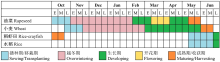
图1
江汉平原作物生长发育物候期图"
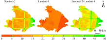
图2
像元尺度的Landsat-8及Sentinel-2高质量影像数量统计"

表1
本研究所采用的植被指数及其计算公式"
| 植被指数 Vegetation index | 公式 Equation | 参考文献 Reference |
|---|---|---|
| 归一化植被指数 NDVI | $N D V I=\frac{\rho_{N I R}-\rho_{R E D}}{\rho_{N I R}+\rho_{R E D}}$ | [ |
| 陆表水分指数 LSWI | $L S W I=\frac{\rho_{\text {NIR }}-\rho_{\text {SWIR } 1}}{\rho_{\text {NIR }}+\rho_{\text {SWIR } 1}}$ | [ |
| 增强型植被指数 EVI | $E V I=\frac{2.5 \times\left(\rho_{\text {SWIR1 }}-\rho_{\text {RED }}\right)}{\rho_{\text {NIR }}+6 \times \rho_{\text {RED }}-7.5 \times \rho_{\text {BLUE }}+1}$ | [ |
| 绿度指数 VIgreen | $\text { VIgreen }=\frac{\rho_{\text {GREEN }}-\rho_{\text {RED }}}{\rho_{\text {GREEN }}+\rho_{\text {RED }}}$ | [ |
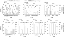
图3
不同时间合成窗口下良好观测影像的平均数量和至少有一次良好观测的像素百分比"

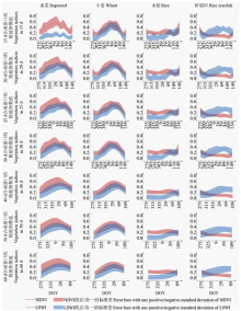
图4
不同时间合成窗口下NDVI与LSWI时序曲线变化"
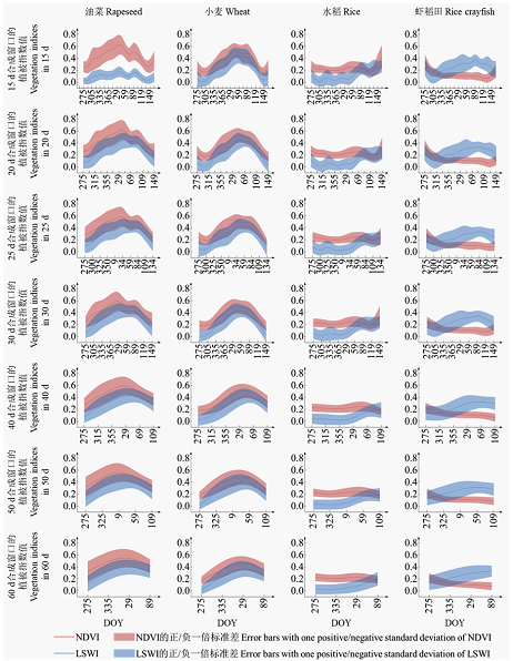
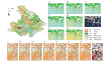
图5
不同时间合成窗口下典型区域的农作物分类结果及2021年3月标准假彩色合成Sentinel-2影像"

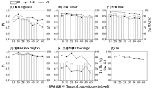
图6
不同时间合成窗口下农作物识别的精度"
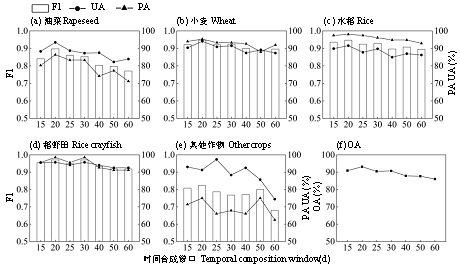
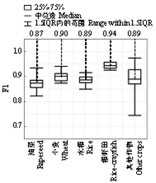
图7
不同时间合成窗口下农作物分类精度变化图"

| [1] |
胡琼, 吴文斌, 宋茜, 余强毅, 杨鹏, 唐华俊. 农作物种植结构遥感提取研究进展. 中国农业科学, 2015, 48(10): 1900-1914. doi: 10.3864/j.issn.0578-1752.2015.10.004.
|
|
|
|
| [2] |
doi: 10.3390/rs13040561 |
| [3] |
doi: 10.3390/rs13142749 |
| [4] |
doi: 10.1016/j.isprsjprs.2021.03.004 |
| [5] |
doi: 10.3390/rs13224522 |
| [6] |
doi: 10.3390/rs13071355 |
| [7] |
doi: 10.3390/rs14184476 |
| [8] |
doi: 10.3390/rs8050434 |
| [9] |
张馨予, 蔡志文, 杨靖雅, 王聪, 魏浩东, 胡琼, 徐保东. 时序滤波对农作物遥感识别的影响. 农业工程学报, 2022, 38(4): 215-224.
|
|
|
|
| [10] |
何真, 胡洁, 蔡志文, 王文静, 胡琼. 协同多时相国产GF-1和GF-6卫星影像的艾草遥感识别. 农业工程学报, 2022, 38(1): 186-195.
|
|
|
|
| [11] |
杨靖雅, 胡琼, 魏浩东, 蔡志文, 张馨予, 宋茜, 徐保东. 基于Sentinel-1/2数据的中国南方单双季稻识别结果一致性分析. 中国农业科学, 2022, 55(16): 3093-3109. doi: 10.3864/j.issn.0578-1752.2022.16.003.
|
|
|
|
| [12] |
doi: 10.1016/j.isprsjprs.2021.03.015 |
| [13] |
doi: 10.3390/rs13050990 |
| [14] |
doi: 10.3390/rs4102890 |
| [15] |
doi: 10.1016/j.rse.2020.111951 |
| [16] |
doi: 10.3390/rs71215820 |
| [17] |
doi: 10.1016/j.isprsjprs.2021.12.001 |
| [18] |
宋茜, 周清波, 吴文斌, 胡琼, 余强毅, 唐华俊. 农作物遥感识别中的多源数据融合研究进展. 中国农业科学, 2015, 48(6): 1122-1135. doi: 10.3864/j.issn.0578-1752.2015.06.09.
|
|
|
|
| [19] |
doi: 10.1016/j.rse.2019.111624 |
| [20] |
doi: 10.3390/rs13132510 |
| [21] |
doi: 10.3390/rs13245183 |
| [22] |
魏浩东, 杨靖雅, 蔡志文, 陈云坪, 张馨予, 徐保东, 胡琼. 物候窗口和多源中高分辨率影像的稻虾田提取. 遥感学报, 2022, 26(7): 1423-1436.
|
|
doi: 10.11834/jrs.20211070 |
|
| [23] |
doi: 10.3390/rs11070820 |
| [24] |
doi: 10.1016/j.isprsjprs.2020.01.001 |
| [25] |
|
| [26] |
doi: 10.3390/rs12122065 |
| [27] |
周惠慧, 王楠, 黄瑶, 王晋年, 张立福. 不同时间间隔下的遥感时间序列重构模型比较分析. 地球信息科学学报, 2016, 18(10): 1410-1417.
doi: 10.3724/SP.J.1047.2016.01410 |
|
|
|
| [28] |
张紫荆, 华丽, 郑萱, 李嘉麟. 基于GEE平台与Sentinel-NDVI时序数据江汉平原种植模式提取. 农业工程学报, 2022, 38(1): 196-202.
|
|
|
|
| [29] |
doi: 10.1016/j.rse.2022.113255 |
| [30] |
doi: 10.1016/j.rse.2016.02.016 pmid: 28025586 |
| [31] |
doi: 10.1109/TGRS.2011.2164087 |
| [32] |
doi: 10.1016/j.rse.2015.12.024 |
| [33] |
doi: 10.1016/j.rse.2018.04.031 |
| [34] |
doi: 10.1016/j.isprsjprs.2014.09.002 |
| [35] |
doi: 10.3390/rs13193994 |
| [36] |
doi: 10.3390/rs15041034 |
| [37] |
doi: 10.1007/s11430-016-5327-3 |
| [38] |
doi: 10.3390/ijgi6080230 |
| [39] |
doi: 10.5194/essd-13-2437-2021 |
| [40] |
doi: 10.1016/j.rse.2006.01.003 |
| [41] |
doi: 10.1080/01431161.2010.531783 |
| [42] |
doi: 10.3390/rs5104799 |
| [43] |
doi: 10.3390/rs13224666 |
| [44] |
doi: 10.1016/j.scitotenv.2021.152690 |
| [45] |
doi: 10.1016/S0034-4257(02)00096-2 |
| [46] |
doi: 10.1016/j.rse.2011.01.009 |
| [47] |
doi: 10.1016/S0034-4257(96)00067-3 |
| [48] |
霍轩琳, 牛振国, 张波, 刘林崧, 李霞. 高寒湿地分类的遥感特征优选研究. 遥感学报, 2023, 27(4): 1045-1060.
|
|
doi: 10.11834/jrs.20222080 |
|
| [49] |
doi: 10.1016/j.rse.2005.10.004 |
| [50] |
doi: 10.1016/j.jag.2021.102351 |
| [51] |
doi: 10.3390/rs10081200 |
| [52] |
doi: 10.1038/s41597-021-00827-9 pmid: 33531510 |
| [53] |
doi: 10.1016/j.jag.2019.04.013 |
| [54] |
doi: 10.3390/rs14133067 |
| [55] |
doi: 10.1016/j.isprsjprs.2011.11.002 |
| [56] |
doi: 10.1016/j.jag.2023.103198 |
| [1] | 冯晓琳, 张楚天, 许晨阳, 耿增超, 胡斐南, 杜伟. 陕西省土壤无机碳的时空分布特征及影响因素[J]. 中国农业科学, 2024, 57(8): 1517-1532. |
| [2] | 王佳玥, 蔡志文, 王文静, 魏浩东, 王聪, 李泽萱, 李秀妮, 胡琼. 协同多源国产高分影像和面向对象方法的南方农作物遥感识别[J]. 中国农业科学, 2023, 56(13): 2474-2490. |
| [3] | 王淑婷, 孔雨光, 张赞, 陈红艳, 刘鹏. 基于星-机光谱融合的棉花叶片SPAD值反演[J]. 中国农业科学, 2022, 55(24): 4823-4839. |
| [4] | 吴俊,郭大千,李果,郭熙,钟亮,朱青,国佳欣,叶英聪. 基于CARS-BPNN的江西省土壤有机碳含量高光谱预测[J]. 中国农业科学, 2022, 55(19): 3738-3750. |
| [5] | 郭灿,岳晓凤,白艺珍,张良晓,张奇,李培武. 花生黄曲霉毒素平衡取样-随机森林风险预警模型的应用研究[J]. 中国农业科学, 2022, 55(17): 3426-3436. |
| [6] | 申哲,张认连,龙怀玉,徐爱国. 基于机器学习方法的宁夏南部土壤质地空间分布研究[J]. 中国农业科学, 2022, 55(15): 2961-2972. |
| [7] | 周珂, 柳乐, 张俨娜, 苗茹, 杨阳. GEE支持下的河南省冬小麦面积提取及长势监测[J]. 中国农业科学, 2021, 54(11): 2302-2318. |
| [8] | 张振华,丁建丽,王敬哲,葛翔宇,王瑾杰,田美玲,赵启东. 集成土壤-环境关系与机器学习的干旱区土壤属性数字制图[J]. 中国农业科学, 2020, 53(3): 563-573. |
| [9] | 奚雪,赵庚星,高鹏,崔昆,李涛. 基于Sentinel卫星及无人机多光谱的滨海冬小麦种植区土壤盐分反演研究——以黄三角垦利区为例[J]. 中国农业科学, 2020, 53(24): 5005-5016. |
| [10] | 夏树凤,王凡,王龙俊,周琴,蔡剑,王笑,黄梅,戴廷波,姜东. 江苏省小麦籽粒蛋白质达标弱筋小麦的适生性分析与评价[J]. 中国农业科学, 2020, 53(24): 4992-5004. |
| [11] | 申哲,张认连,龙怀玉,王转,朱国龙,石乾雄,喻科凡,徐爱国. 基于3种空间预测方法的黄土区土壤颗粒组成空间分布研究—以宁夏海原县为例[J]. 中国农业科学, 2020, 53(18): 3716-3728. |
| [12] | 张春兰,杨贵军,李贺丽,汤伏全,刘畅,张丽妍. 基于随机森林算法的冬小麦叶面积指数遥感反演研究[J]. 中国农业科学, 2018, 51(5): 855-867. |
| [13] | 王飞,杨胜天,魏阳,杨晓东,丁建丽. 基于RF和SGT算法的子区优先建模对绿洲尺度 土壤盐度预测精度的影响[J]. 中国农业科学, 2018, 51(24): 4659-4676. |
| [14] | 贺英,邓磊,毛智慧,孙杰. 基于数码相机的玉米冠层SPAD遥感估算[J]. 中国农业科学, 2018, 51(15): 2886-2897. |
| [15] | 刘亚秋,陈红艳,王瑞燕,常春艳,陈哲. 基于可见/近红外光谱的黄河口区土壤盐分及其主要离子的定量分析[J]. 中国农业科学, 2016, 49(10): 1925-1935. |
|
||