


中国农业科学 ›› 2025, Vol. 58 ›› Issue (20): 4054-4069.doi: 10.3864/j.issn.0578-1752.2025.20.003
所属专题: 专刊——盐碱地智慧监测与生态化利用
李明丽1,2( ), 温彩运1, 马东豪3, 李存军4, 王宇文1, 康璐1, 陆苗1,2()
收稿日期:2025-07-23
接受日期:2025-09-24
出版日期:2025-10-16
发布日期:2025-10-14
通信作者:
联系方式:
李明丽,E-mail:2236072794@qq.com。
基金资助:
LI MingLi1,2(), WEN CaiYun1, MA DongHao3, LI CunJun4, WANG YuWen1, KANG Lu1, LU Miao1,2()
Received:2025-07-23
Accepted:2025-09-24
Published:2025-10-16
Online:2025-10-14
摘要:
【目的】土壤盐渍化导致土壤结构恶化、作物减产及生态系统退化,是威胁干旱区农业可持续发展的关键环境问题。本研究旨在利用光谱变换、波段筛选以及多种机器学习方法,构建土壤盐分预测模型,快速、准确地预测土壤盐分,为盐渍化农田的科学管理提供技术支撑。【方法】以达拉特旗农田土壤为研究对象,系统采集土壤样品并测定其电导率(EC)与光谱反射率数据。首先,采用Savitzky-Golay(S-G)滤波对原始光谱(R)进行平滑去噪,在此基础上系统开展包括倒数、对数、一阶微分、二阶微分等在内的12种光谱变换处理,以挖掘隐含光谱特征。进而,分别采用相关性分析(CA)和最小角回归(LAR)方法进行特征降维,并结合竞争性自适应重加权采样(CARS)算法进一步筛选敏感特征波段。最后,基于优选特征分别构建偏最小二乘回归(PLSR)、支持向量机(SVM)、反向传播神经网络(BPNN)和随机森林(RF)模型,通过决定系数(R2)和均方根误差(RMSE)综合评价模型性能,对比特征集在不同算法中的建模效果。【结果】原始光谱经过光谱变换后,相关系数均有不同程度的提升,表明光谱变换能显著增强土壤盐分与光谱特征的相关性;在使用竞争性自适应重加权采样进行特征波段优选时,最小角回归比相关性分析具有更好的特征降维效果;倒数对数一阶微分(ATFD)结合偏最小二乘回归模型表现最优,其验证集精度为R2=0.81、RMSE=2.04 dS·m-1;不同建模方法对比显示,偏最小二乘回归模型的预测性能优于其他3种模型(反向传播神经网络/随机森林/支持向量机),表明偏最小二乘回归模型更适合该区域土壤盐分的预测。【结论】基于ATFD-LAR-CARS-PLSR的土壤盐分高光谱预测模型精度高、预测能力最优,证实了高光谱技术结合多维度特征优化可有效实现干旱区土壤盐分预测。
李明丽, 温彩运, 马东豪, 李存军, 王宇文, 康璐, 陆苗. 基于土壤高光谱特征波段优选的盐分预测模型构建[J]. 中国农业科学, 2025, 58(20): 4054-4069.
LI MingLi, WEN CaiYun, MA DongHao, LI CunJun, WANG YuWen, KANG Lu, LU Miao. Construction of Salinity Prediction Model Based on Optimal Selection of Soil Hyperspectral Characteristic Bands[J]. Scientia Agricultura Sinica, 2025, 58(20): 4054-4069.
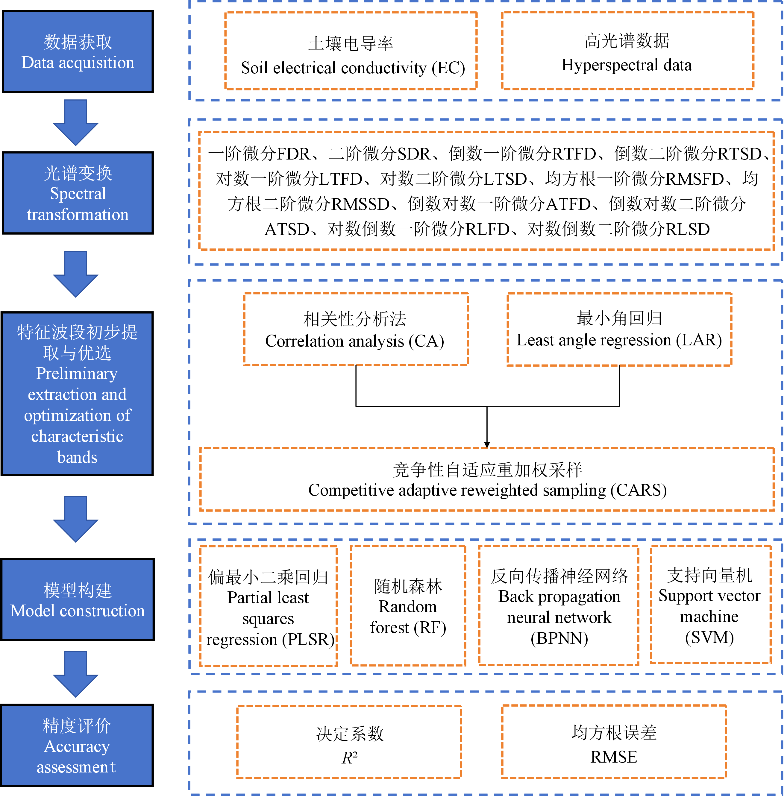
图1
研究方法流程图"
表1
土壤电导率描述性统计"
| 盐渍化等级 Salinization grade | 样本数量 Sample size | 最大值 Max (dS·m-1) | 最小值 Min (dS·m-1) | 平均值 Mean (dS·m-1) | 标准差 SD (dS·m-1) | 变异系数 CV (%) |
|---|---|---|---|---|---|---|
| 非盐渍化Non-salinized (0-2 dS·m-1) | 78 | 1.92 | 0.08 | 0.63 | 0.40 | 63.49 |
| 轻度盐渍化Slightly salinized (2-4 dS·m-1) | 14 | 3.91 | 2.10 | 3.00 | 0.57 | 16.64 |
| 中度盐渍化Moderately salinized (4-8 dS·m-1) | 37 | 7.90 | 4.05 | 6.57 | 1.07 | 16.29 |
| 重度盐渍化Heavily salinized (8-16 dS·m-1) | 36 | 15.16 | 8.08 | 11.41 | 1.92 | 16.83 |
| 盐土Saline soil (>16 dS·m-1) | 3 | 19.43 | 17.91 | 18.60 | 0.77 | 4.14 |

图2
不同程度盐渍化的土壤光谱反射率曲线"
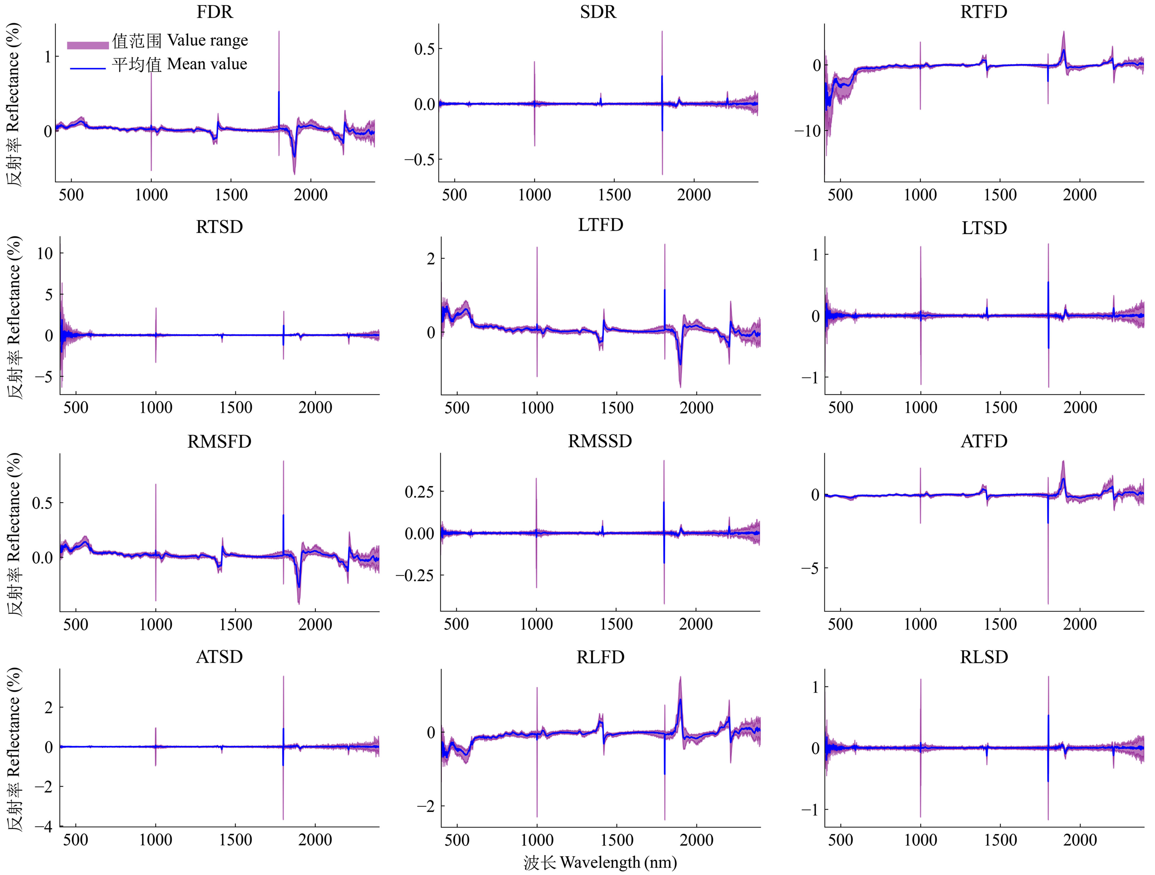
图3
不同光谱变换后的反射率"
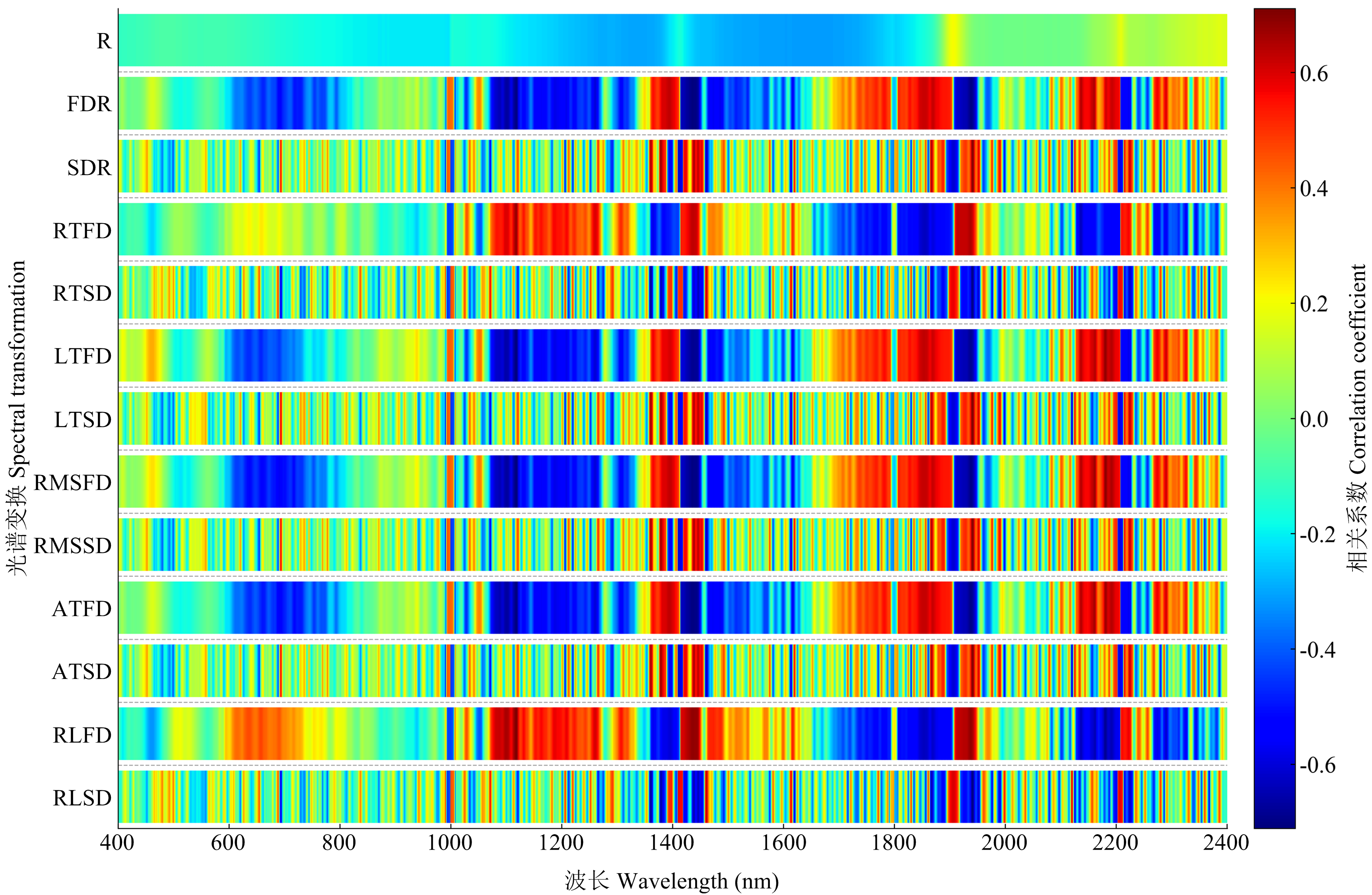
图4
土壤电导率与原始光谱、光谱变换结果的相关系数矩阵"
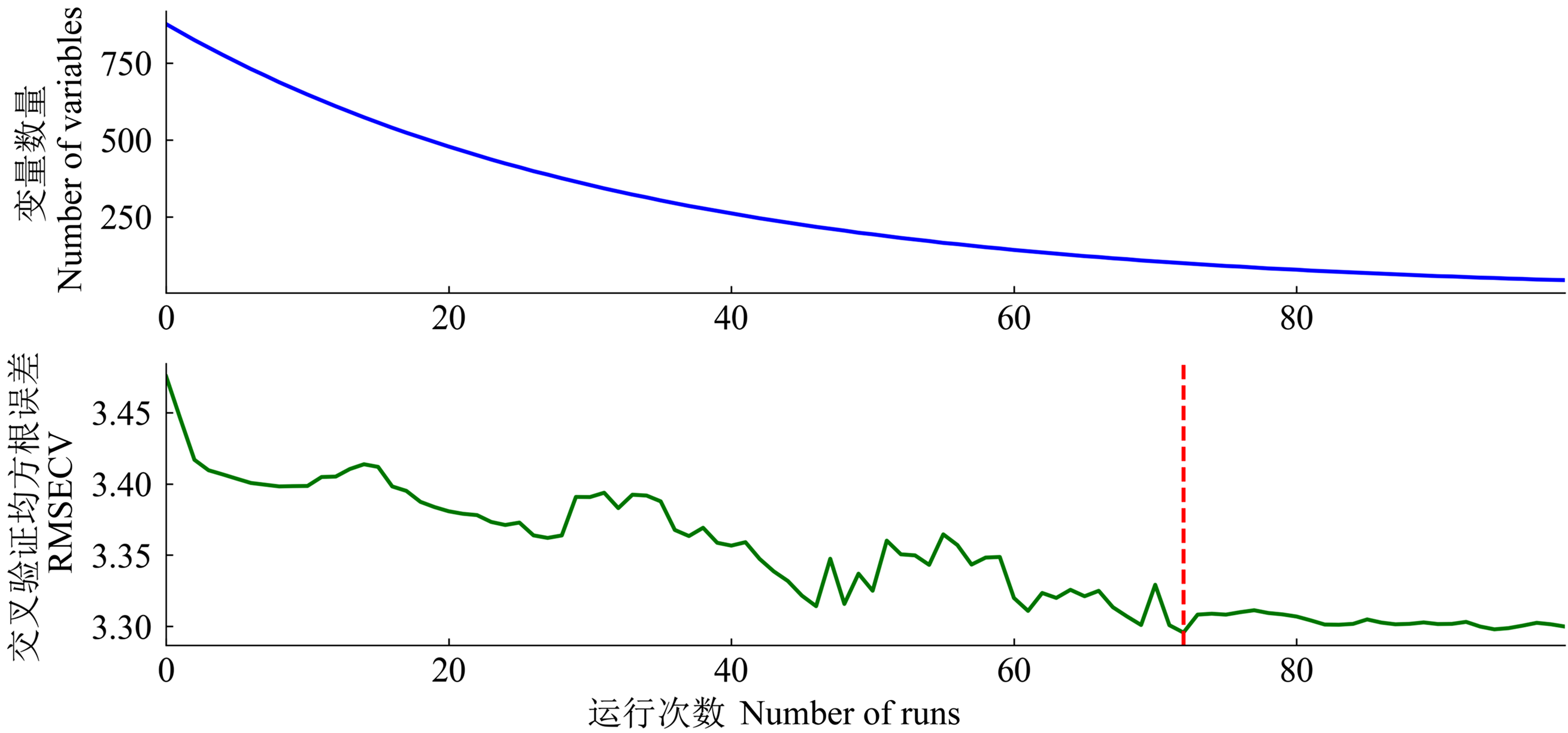
图5
CARS提取波段过程与结果(以原始光谱R为例)"

图6
CA-CARS方法的波段提取结果"

图7
LAR-CARS方法的波段提取结果"
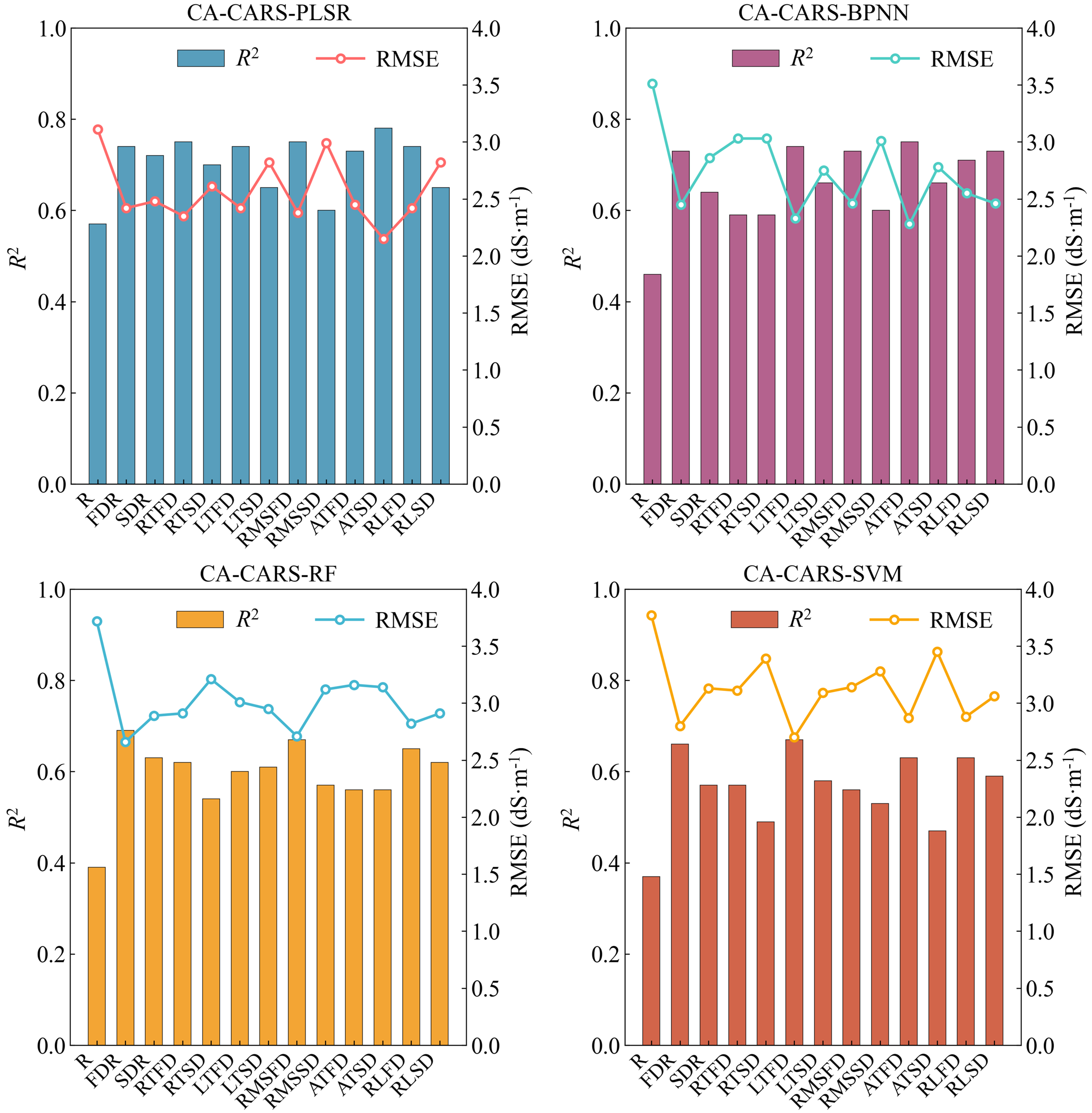
图8
基于CA-CARS方法下4种模型精度比较"
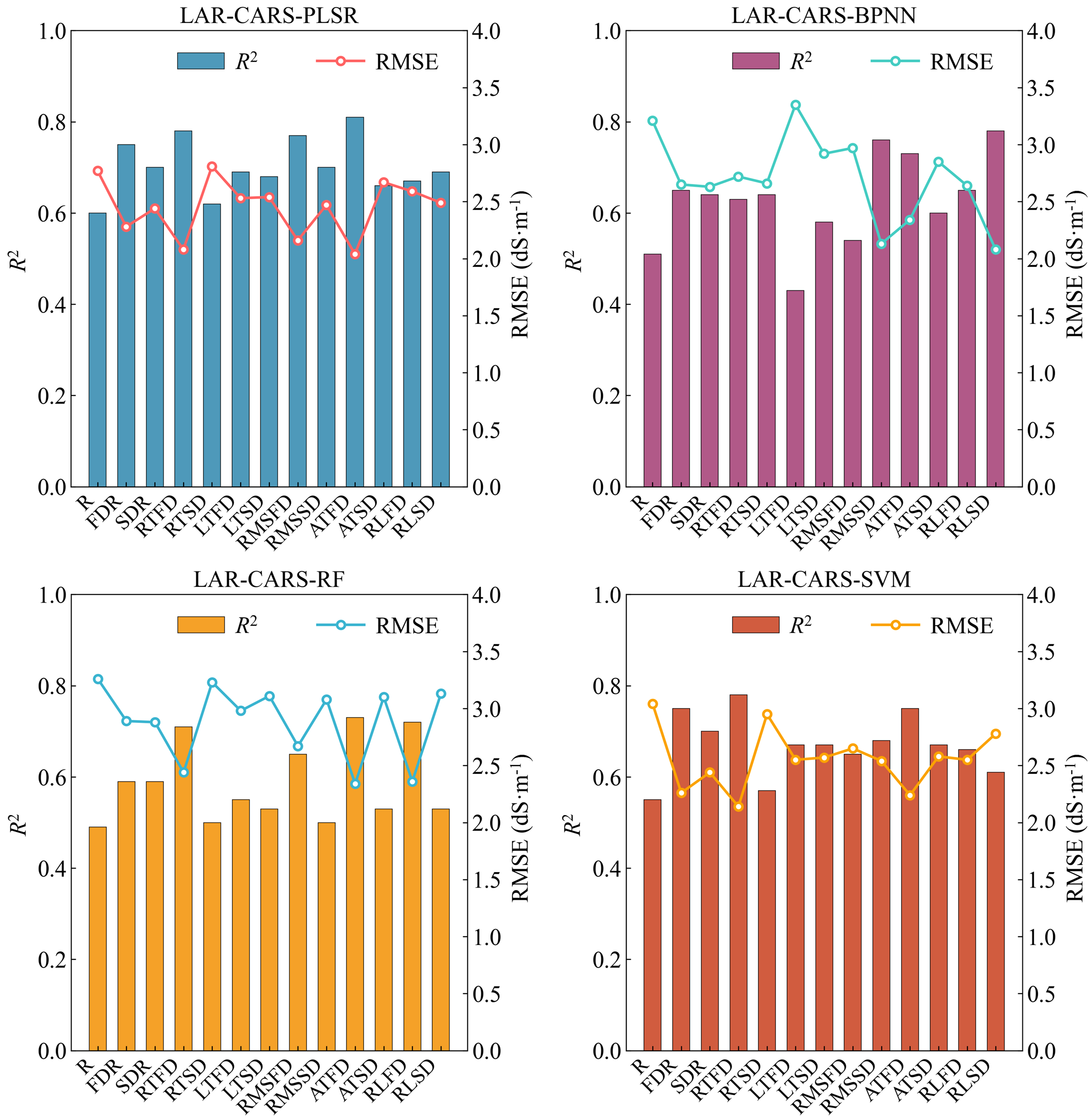
图9
基于LAR-CARS方法下4种模型精度比较"
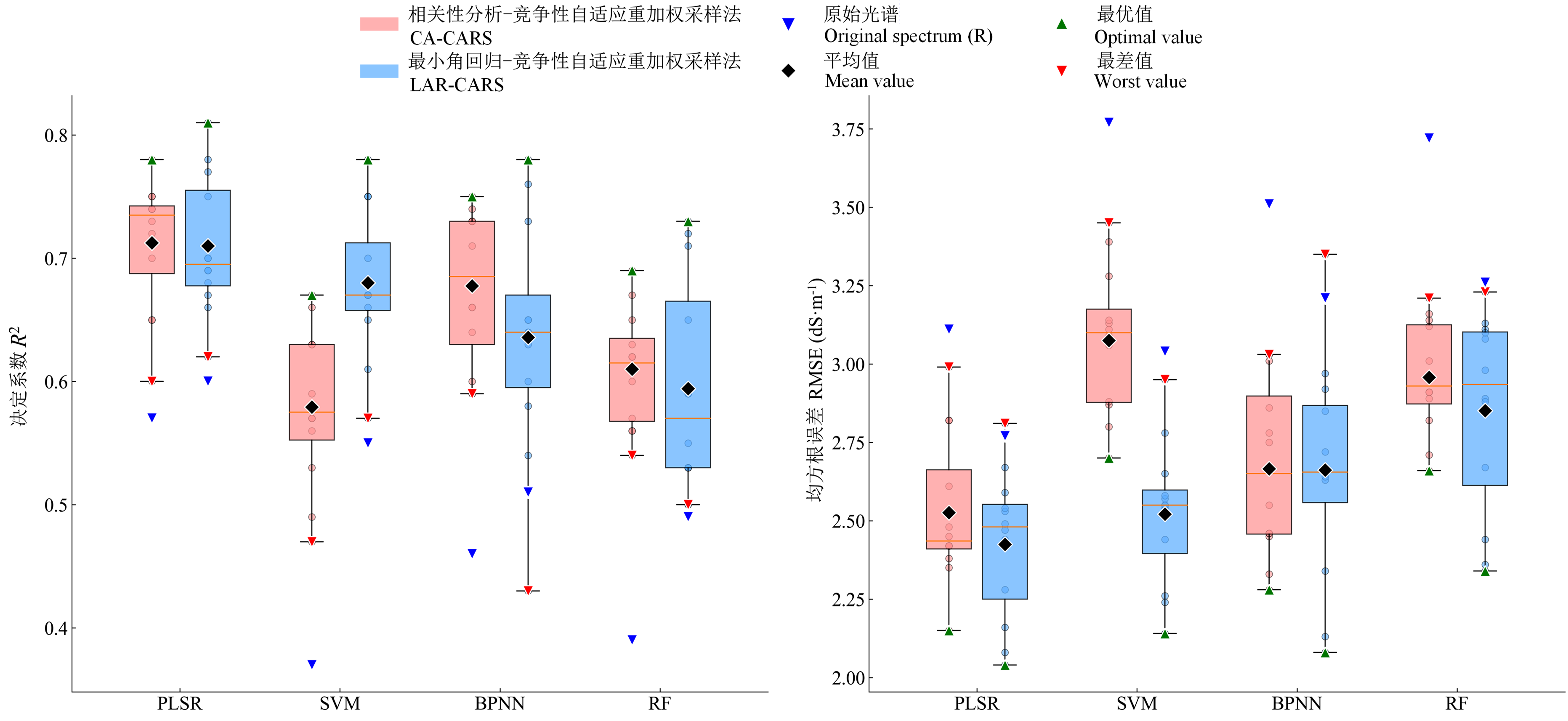
图10
CA-CARS与LAR-CARS算法的对比"
| [1] |
刘霞, 胡宇, 张圣微, 白燕英, 张欢. 达拉特旗黄河南岸盐碱化土壤不同含盐量估算模型对比. 农业机械学报, 2024, 55(10): 360-370.
|
|
|
|
| [2] |
顾晨, 梁建, 刘旭颖, 孙泊远, 孙同生, 俞坚钢, 孙晨曦, 万华伟, 高吉喜. 高光谱遥感在草原植物多样性监测中的应用与展望. 应用生态学报, 2024, 35(5): 1397-1407.
doi: 10.13287/j.1001-9332.202405.024 |
|
doi: 10.13287/j.1001-9332.202405.024 |
|
| [3] |
郭艳萍, 王雪梅, 赵枫, 李平平. 基于最优数学和小波变换的绿洲耕层土壤盐分RF高光谱反演. 农业工程学报, 2025, 41(3): 83-93.
|
|
|
|
| [4] |
王英杰, 高欣梅, 包淑梅, 李乌日吉木斯, 福英, 乌日力格, 王靖宇, 郭龙玉. 基于高光谱数据的盐渍化土壤含盐量预测模型研究. 农业工程, 2024, 14(10): 113-120.
|
|
|
|
| [5] |
王丽娜, 朱西存, 刘庆, 赵庚星, 李海燕, 王凌, 张圣武. 黄河三角洲盐碱土盐分的高光谱定量估测研究. 土壤通报, 2013, 44(5): 1101-1106.
|
|
|
|
| [6] |
|
| [7] |
侯化刚, 王丹阳, 马斯琦, 潘剑君, 李兆富. 黄河三角洲不同盐渍度土壤有机质含量的高光谱预测研究. 中国农业科学, 2023, 56(10): 1905-1919. doi: 10.3864/j.issn.0578-1752.2023.10.008.
|
|
|
|
| [8] |
彭金英, 蒋金豹, 崔希民, 张建, 王思佳, 王明国, 聂铖. 宁夏盐碱地土壤盐分高光谱反演. 矿山测量, 2021, 49(1): 69-73.
|
|
|
|
| [9] |
赵泽艺, 李朝阳, 王洪博, 张楠, 李国辉, 唐茂淞, 王兴鹏, 高阳. 南疆盐碱土水、氮、盐光谱特征及其反演模型. 灌溉排水学报, 2023, 42(7): 93-100.
|
|
|
|
| [10] |
|
| [11] |
|
| [12] |
朱赟, 申广荣, 项巧巧, 吴裕. 基于不同光谱变换的土壤盐含量光谱特征分析. 土壤通报, 2017, 48(3): 560-568.
|
|
|
|
| [13] |
黄华雨, 丁启东, 张俊华, 周跃辉, 潘鑫, 贾科利. 地面高光谱耦合可解释性集成机器学习的农田土壤含盐量和pH反演. 环境科学, 2025, doi: 10.13227/j.hjkx.202412303.
|
|
|
|
| [14] |
张晓娟, 张忠, 杨雪梅, 宋龙龙, 王景瑞, 王飞. 基于高光谱的景电灌区盐渍化土壤水、盐估算研究. 甘肃林业科技, 2024, 49(3): 60-66.
|
|
|
|
| [15] |
赵慧, 李新国, 靳万贵, 麦麦提吐尔逊·艾则孜, 牛芳鹏. 基于分数阶微分的博斯腾湖湖滨绿洲土壤电导率高光谱估算. 甘肃农业大学学报, 2021, 56(1): 118-125.
|
|
|
|
| [16] |
陈睿华, 孙媛, 尚天浩, 张俊华. 基于光谱变换的宁夏银北地区可溶性阴离子反演. 中国土壤与肥料, 2022(8): 94-103.
|
|
|
|
| [17] |
孙亚楠, 李仙岳, 史海滨, 崔佳琪, 王维刚. 河套灌区土壤水溶性盐基离子高光谱综合反演模型. 农业机械学报, 2019, 50(5): 344-355.
|
|
|
|
| [18] |
周世勋, 尹娟, 王军涛, 常布辉, 杨震. 灌区土壤含盐量的高光谱估测与空间分布研究. 灌溉排水学报, 2025, 44(2): 72-82.
|
|
|
|
| [19] |
孟珊, 李新国, 焦黎. 基于机器学习算法的湖滨绿洲土壤电导率高光谱估算模型. 土壤通报, 2023, 54(2): 286-294.
|
|
|
|
| [20] |
|
| [21] |
贾学宇, 郝永河, 张娟, 刘子瑶. 鄂尔多斯市黄河灌区重度盐碱地与作物主要表型性状的相关性分析. 黑龙江科学, 2025, 16(8): 92-95.
|
|
|
|
| [22] |
穆其尔, 杨光, 陈昊宇, 张天琪. 实验室模拟不同盐分土壤的高光谱特性. 东北林业大学学报, 2021, 49(11): 68-75.
|
|
|
|
| [23] |
高颖, 王延仓, 顾晓鹤, 周新武, 马样, 宣孝义. 基于微分变换定量反演土壤有机质及全氮含量. 江苏农业科学, 2020, 48(24): 220-225.
|
|
|
|
| [24] |
代希君, 彭杰, 张艳丽, 罗华平, 向红英. 基于光谱分类的土壤盐分含量预测. 土壤学报, 2016, 53(4): 909-918.
|
|
|
|
| [25] |
张俊华, 贾萍萍, 孙媛, 贾科利. 基于高光谱特征的盐渍化土壤不同土层盐分离子含量预测. 农业工程学报, 2019, 35(12): 106-115.
|
|
|
|
| [26] |
李志, 李新国, 刘彬, 麦麦提吐尔逊·艾则孜. 博斯腾湖西岸湖滨带土壤盐分高光谱反演. 扬州大学学报(农业与生命科学版), 2019, 40(2): 33-39.
|
|
|
|
| [27] |
|
| [28] |
|
| [29] |
熊芩, 张若秋, 李辉, 陈万超, 杜一平. 最小角回归算法(LAR)结合采样误差分布分析(SEPA)建立稳健的近红外光谱分析模型. 分析测试学报, 2018, 37(7): 778-783.
|
|
|
|
| [30] |
doi: 10.1016/j.aca.2009.06.046 pmid: 19616692 |
| [31] | |
|
|
|
| [32] |
|
| [33] |
|
| [34] |
|
| [35] |
如则麦麦提·米吉提, 买买提·沙吾提, 麦尔耶姆·亚森, 马春玥. 基于高光谱的干旱区盐渍化土壤盐分含量估算. 江苏农业科学, 2018, 46(22): 265-269.
|
|
REZEMAMET·M, MAMAT·S, MAERYAM·Y,
|
|
| [36] |
周凤玺, 滕祥帅, 郝君明, 王立业. 不同分数阶微分形式在盐渍土电导率高光谱反演中的适用性研究. 光谱学与光谱分析, 2025, 45(1): 272-281.
|
|
|
|
| [37] |
王建雯, 李振海, 朱红春, 徐新刚, 甘平, 王浩森, 杨贵军. 基于野外实测高光谱数据的盐碱土盐分含量估测研究. 山东科技大学学报(自然科学版), 2017, 36(3): 17-24.
|
|
|
|
| [38] |
|
| [39] |
|
| [40] |
张楠楠, 张晓. 南疆枣园盐渍土电导率的近红外高光谱分析. 东北农业科学, 2022, 47(4): 118-121, 154.
|
|
|
|
| [41] |
|
| [42] |
栗方亮, 孔庆波, 张青. 基于光谱指数的琯溪蜜柚叶片钙素含量估测模型研究. 中国农业科学, 2025, 58(7): 1321-1332. doi: 10.3864/j.issn.0578-1752.2025.07.006.
|
|
|
|
| [43] |
|
| [44] |
郭鹏, 赵阳, 孙子皓, 陈秀万. 基于CARS-PLSR算法的土壤有效磷高光谱反演研究. 中国农业信息, 2023, 35(1): 55-66.
|
|
|
|
| [45] |
谭琨, 叶元元, 杜培军, 张倩倩. 矿区复垦农田土壤重金属含量的高光谱反演分析. 光谱学与光谱分析, 2014, 34(12): 3317-3322.
pmid: 25881431 |
|
pmid: 25881431 |
|
| [46] |
骆振海, 张超, 冯绍元, 唐敏, 刘锐, 孔纪迎. 土壤盐渍化光学遥感监测方法研究进展. 自然资源遥感, 2024, 36(4): 9-22.
|
|
|
| [1] | 巨晓军, 章明, 刘一帆, 姬改革, 单艳菊, 屠云洁, 邹剑敏, 张海涛, 卞良永, 束婧婷. 整合肠道菌群与小分子代谢物分析调控肉鸡饲料转化率的影响因素[J]. 中国农业科学, 2025, 58(6): 1223-1238. |
| [2] | 王龙, 王军, 蒋静, 刘浩, 刘德召, 李久生. 滴灌不同用量的氮钾肥对土壤盐分及南疆香梨产量、品质的影响[J]. 中国农业科学, 2025, 58(17): 3473-3487. |
| [3] | 吕金岭, 尤克, 王小非, 肖强, 李文峰, 马进, 杨清, 张金平, 孔海江, 常运华. 河南省典型农区近地表大气氨时空分布特征及主要影响因素[J]. 中国农业科学, 2025, 58(1): 127-140. |
| [4] | 付山, 梁邺, 徐玖亮, 阮云泽, 罗剑, 李婷玉. 基于多种方法的菠萝果实质地及食味品质综合评价[J]. 中国农业科学, 2023, 56(15): 3006-3019. |
| [5] | 相玉婷, 王晓龙, 胡新中, 任长忠, 郭来春, 李璐. 燕麦品种间脂肪酶活性差异及低脂肪酶优质品种的预测[J]. 中国农业科学, 2022, 55(21): 4104-4117. |
| [6] | 刘丰,蒋佳丽,周琴,蔡剑,王笑,黄梅,仲迎鑫,戴廷波,曹卫星,姜东. 美国软麦籽粒品质变化趋势及对我国弱筋小麦标准达标度分析[J]. 中国农业科学, 2022, 55(19): 3723-3737. |
| [7] | 冯俊杰,赵文达,张新全,刘英杰,袁帅,董志晓,熊毅,熊艳丽,凌瑶,马啸. 引种日本多花黑麦草标准品种DUS性状变异分析及应用[J]. 中国农业科学, 2022, 55(12): 2447-2460. |
| [8] | 张婷,王根平,罗焱杰,李琳,高翔,程汝宏,师志刚,董立,张喜瑞,杨伟红,许立闪. 色差分析在优质小米选育中的应用[J]. 中国农业科学, 2021, 54(5): 901-908. |
| [9] | 李凯峰,尹玉和,王琼,林团荣,郭华春. 不同马铃薯品种挥发性风味成分及代谢产物相关性分析[J]. 中国农业科学, 2021, 54(4): 792-803. |
| [10] | 张斌斌,蔡志翔,沈志军,严娟,马瑞娟,俞明亮. 观赏桃种质资源表型性状多样性评价[J]. 中国农业科学, 2021, 54(11): 2406-2418. |
| [11] | 奚雪,赵庚星,高鹏,崔昆,李涛. 基于Sentinel卫星及无人机多光谱的滨海冬小麦种植区土壤盐分反演研究——以黄三角垦利区为例[J]. 中国农业科学, 2020, 53(24): 5005-5016. |
| [12] | 朱子健,陈思雨,粟俊,陶永胜. 刺葡萄酒酒精发酵过程中氨基酸组成与果香酯类物质 生成的关联分析[J]. 中国农业科学, 2020, 53(11): 2272-2284. |
| [13] | 方慧婷,蒙继华,程志强. 基于遥感与作物模型的土壤速效养分时空变异分析[J]. 中国农业科学, 2019, 52(3): 478-490. |
| [14] | 王飞,杨胜天,魏阳,杨晓东,丁建丽. 基于RF和SGT算法的子区优先建模对绿洲尺度 土壤盐度预测精度的影响[J]. 中国农业科学, 2018, 51(24): 4659-4676. |
| [15] | 王阳,王文辉,贾晓辉,佟伟,王志华,杨晓龙. 梨不同品种果实冻藏品质性状分析与适宜品种筛选[J]. 中国农业科学, 2017, 50(17): 3400-3412. |
|
||