


中国农业科学 ›› 2026, Vol. 59 ›› Issue (4): 765-780.doi: 10.3864/j.issn.0578-1752.2026.04.005
罗伟1( ), 余洪2, 袁立新1, 王玲玲1, 赵金鹏3,5, 殷伟2, 王明田4,5, 王茹琳3,5()
收稿日期:2025-07-16
出版日期:2026-02-10
发布日期:2026-02-10
通信作者:
联系方式:
罗伟,E-mail:304448599@qq.com。
基金资助:
LUO Wei1(), YU Hong2, YUAN LiXin1, WANG LingLing1, ZHAO JinPeng3,5, YIN Wei2, WANG MingTian4,5, WANG RuLin3,5()
Received:2025-07-16
Published:2026-02-10
Online:2026-02-10
摘要:
【目的】开展气候变化背景下川渝地区再生稻地理分布的模拟、预测,为我国川渝地区再生稻种植区扩面规划、品种选育以及栽培制度的制定提供科学参考。【方法】基于川渝地区再生稻过去(1981—2000年)53个、当前(2001—2020年)147个分布点和6个环境变量,利用MaxEnt模型模拟气候变化下川渝地区再生稻种植区变化和潜在适宜区变迁,确定影响其分布的主导环境变量。【结果】(1)安全生长期积温(Tac)、安全生长期天数(Day)、9月平均气温(Tav9)、海拔(Alt)是影响再生稻地理分布格局变迁的主导环境变量。(2)过去至当前(1981—2020年),再生稻种植区和潜在适宜区均向盆西北延伸,面积分别扩张至0.44×10⁴和3.25×10⁴ km2,增幅为69.23%和60.89%,分别位于28°9'—30°55'N、103°35'—108°32'E和28°4'—31°48'N、103°10'—110°4'E;高适宜区向西北、东北方向延伸,主要位于28°7'—31°7'N、103°26'—107°21' E,与种植区的分布、变化耦合度高。(3)当前至未来(2001—2060年),SSP245和SSP585情景下再生稻适宜区呈向西北方向延伸、面积增加趋势,适宜区西北界延伸至成都中部-广元中部一线以南,总适宜区面积增幅在3.69%—16.92%。其中,高适宜区向西北延伸至眉山东坡区-达州市达川区一线,向北推进1.4°N(155.65 km)、向西推进0.8°E(88.94 km),面积增幅在45.24%—65.18%;四川宜宾中部和重庆綦江、荣昌、大足的部分高适宜区面积缩减,占比2.68%—11.90%;不变区域主要集中在川南渝西地区,占比72.32%—88.10%。【结论】气候变化总体有利于川渝地区再生稻适宜区域扩张,安全生长期积温和天数的增加,是导致再生稻气候适宜区扩大的主要原因。建议优先巩固川南渝西传统优势区,稳步扩大乐山东北部、资阳西部和东部、遂宁南部、南充南部、达州西南部,以及重庆潼南大部、铜梁北部等新增适宜区,探索拓展成都东部、德阳和绵阳南部等再生稻潜力区,分阶段分区域协同促进再生稻生产持续稳定发展。同时,强化全球气候变暖背景下再生稻生产中气象灾害的监测与预警防控技术研发及应用。
罗伟, 余洪, 袁立新, 王玲玲, 赵金鹏, 殷伟, 王明田, 王茹琳. 全球气候变化背景下川渝地区再生稻地理分布格局变迁[J]. 中国农业科学, 2026, 59(4): 765-780.
LUO Wei, YU Hong, YUAN LiXin, WANG LingLing, ZHAO JinPeng, YIN Wei, WANG MingTian, WANG RuLin. Change of Geographic Distributions of Ratoon Rice in Sichuan- Chongqing Under Global Climate Change[J]. Scientia Agricultura Sinica, 2026, 59(4): 765-780.
表1
影响再生稻分布的潜在环境变量"
| 代码Code | 环境变量 Environmental variable | 生物学意义 Biological significance |
|---|---|---|
| Tac | 安全生长期积温 Safe growth period accumulated temperature (℃·d) | 表征中稻安全播种(稳定通过10 ℃初日)到再生稻安全齐穗(稳定通过22 ℃终日)所需的热量 Characterize the amount of heat required for safe sowing of middle-season rice (stable through ≥10 ℃ on the first day) to safe panicle filling of ratoon rice (stable through ≥22 ℃ all day long) |
| Day | 安全生长期天数 Safe growth period days (d) | 表征中稻安全播种(稳定通过10 ℃初日)到再生稻安全齐穗(稳定通过22 ℃终日)所需的天数 Characterize the number of days required for safe sowing of middle-season rice (stable through ≥10 ℃ on the first day) to safe panicle filling of ratoon rice (stable through ≥22 ℃ all day long) |
| K8 | 8月水热系数 Hydrothermal coefficient in August | 反映再生稻发苗期高温低湿环境对发苗数的胁迫 Reflecting the stress of high temperature and low humidity environment on the number of seedlings during the seedling stage of ratoon rice |
| Tav9 | 9月平均气温 Average temperature in September (℃) | 表征再生稻抽穗扬花期温度对结实率的限制 The limitation of temperature in heading and flowering period of ratoon rice on seed setting rate |
| Prec3_9 | 3—9月降水量 Precipitation from March to September (mm) | 反映“中稻+再生稻”完成生育过程的水分供应量 The water supply of "medium rice + ratoon rice" during the growth process |
| Alt | 海拔 Altitude (m) | 表征不同海拔下综合环境因素对再生稻生长的影响 Effects of comprehensive environmental factors on the growth of ratoon rice at different altitudes |
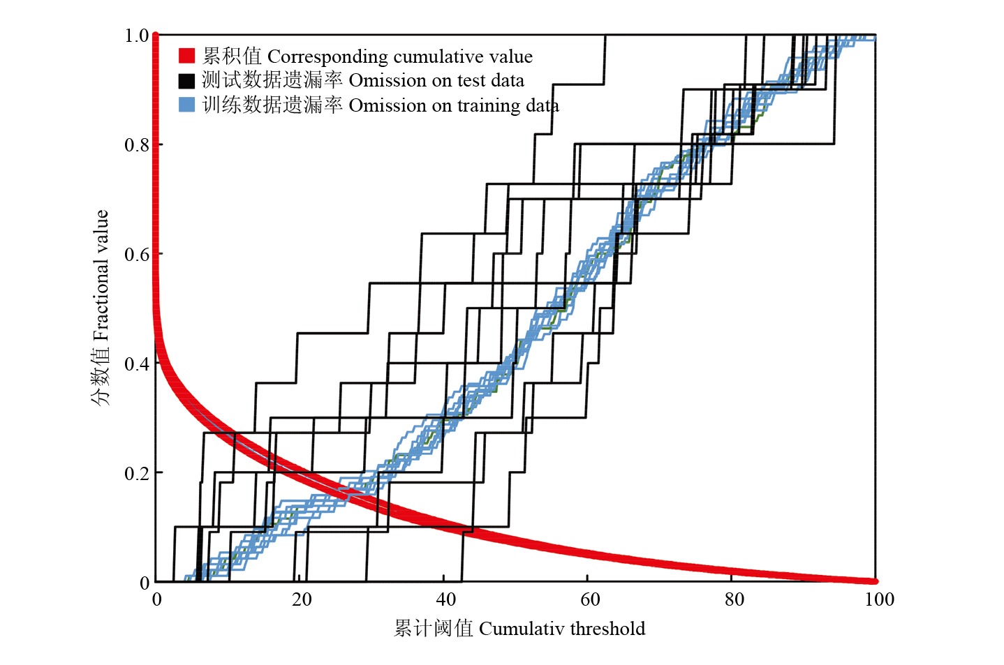
图1
模型预测遗漏率"
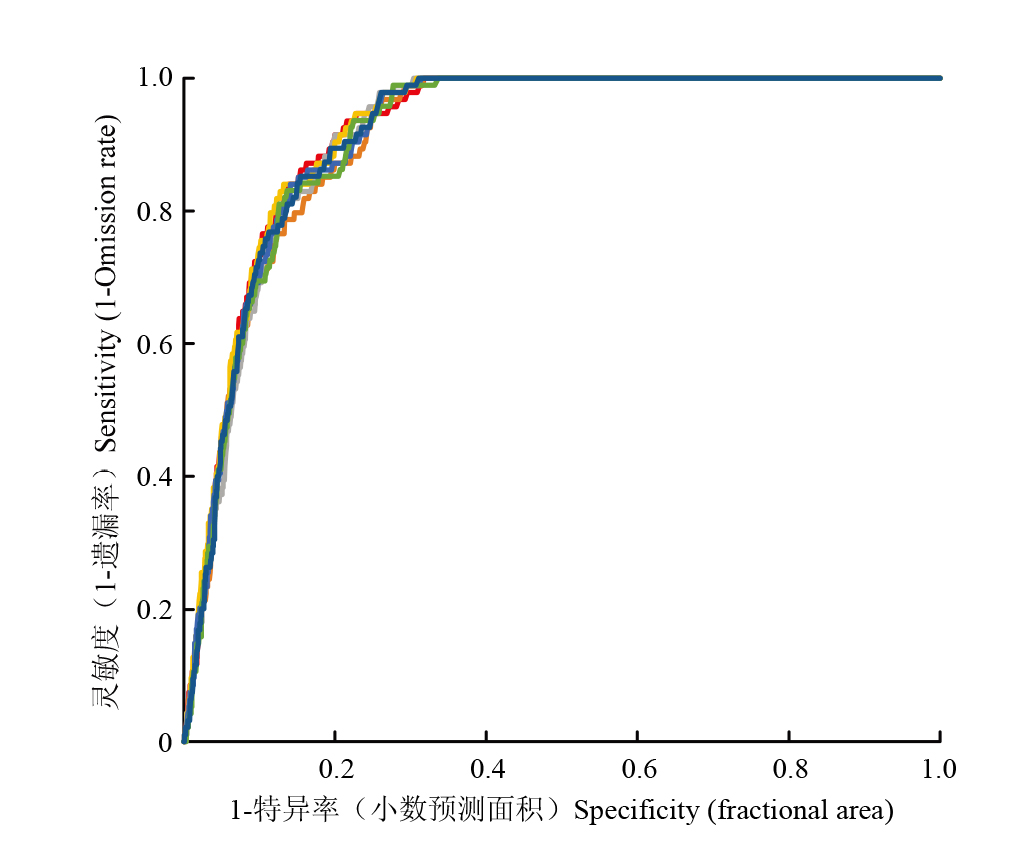
图2
模型ROC曲线及AUC值"
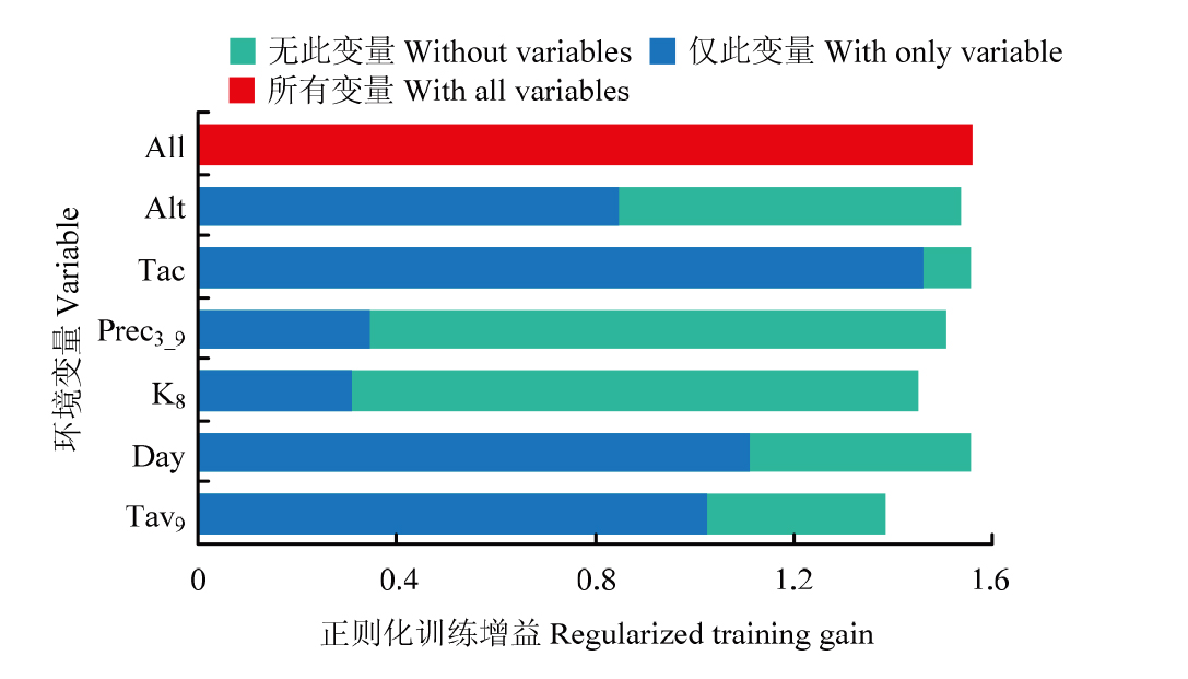
图3
刀切法检验环境变量的重要性"
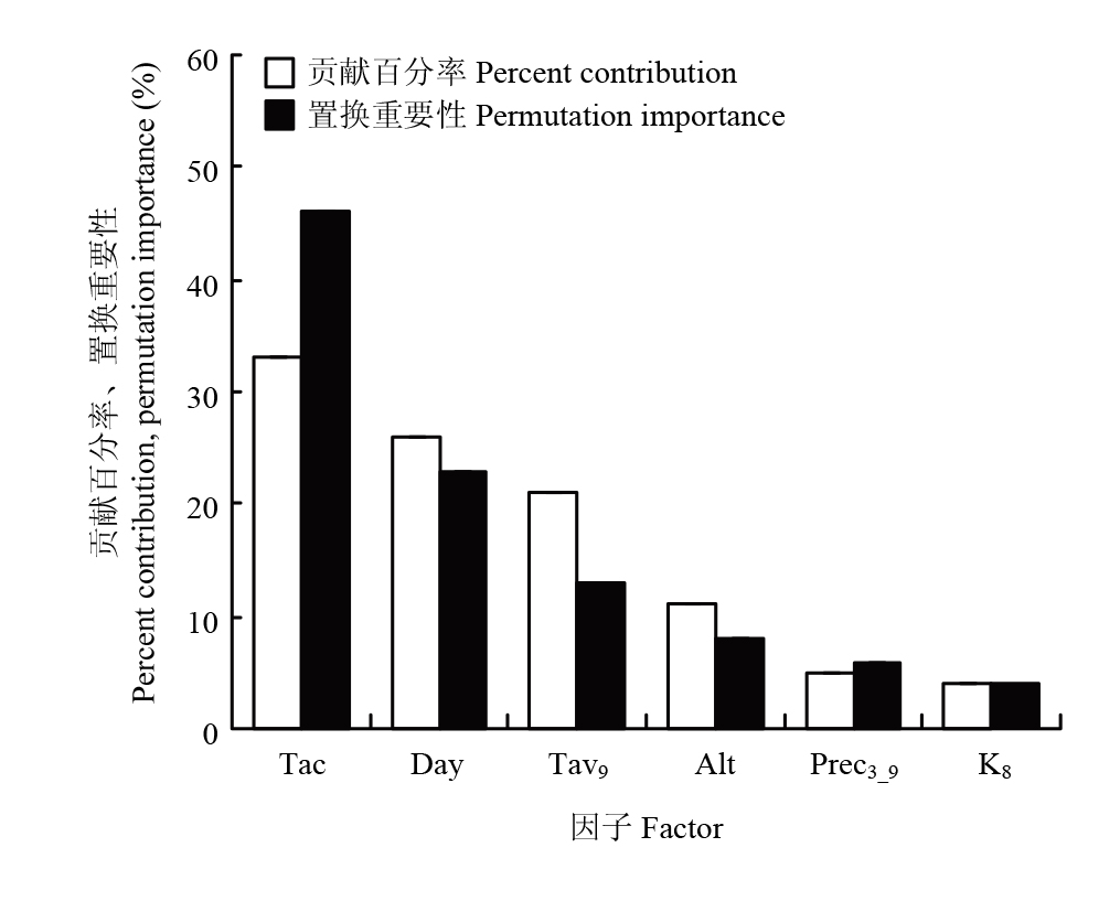
图4
环境变量的贡献率和置换重要性"
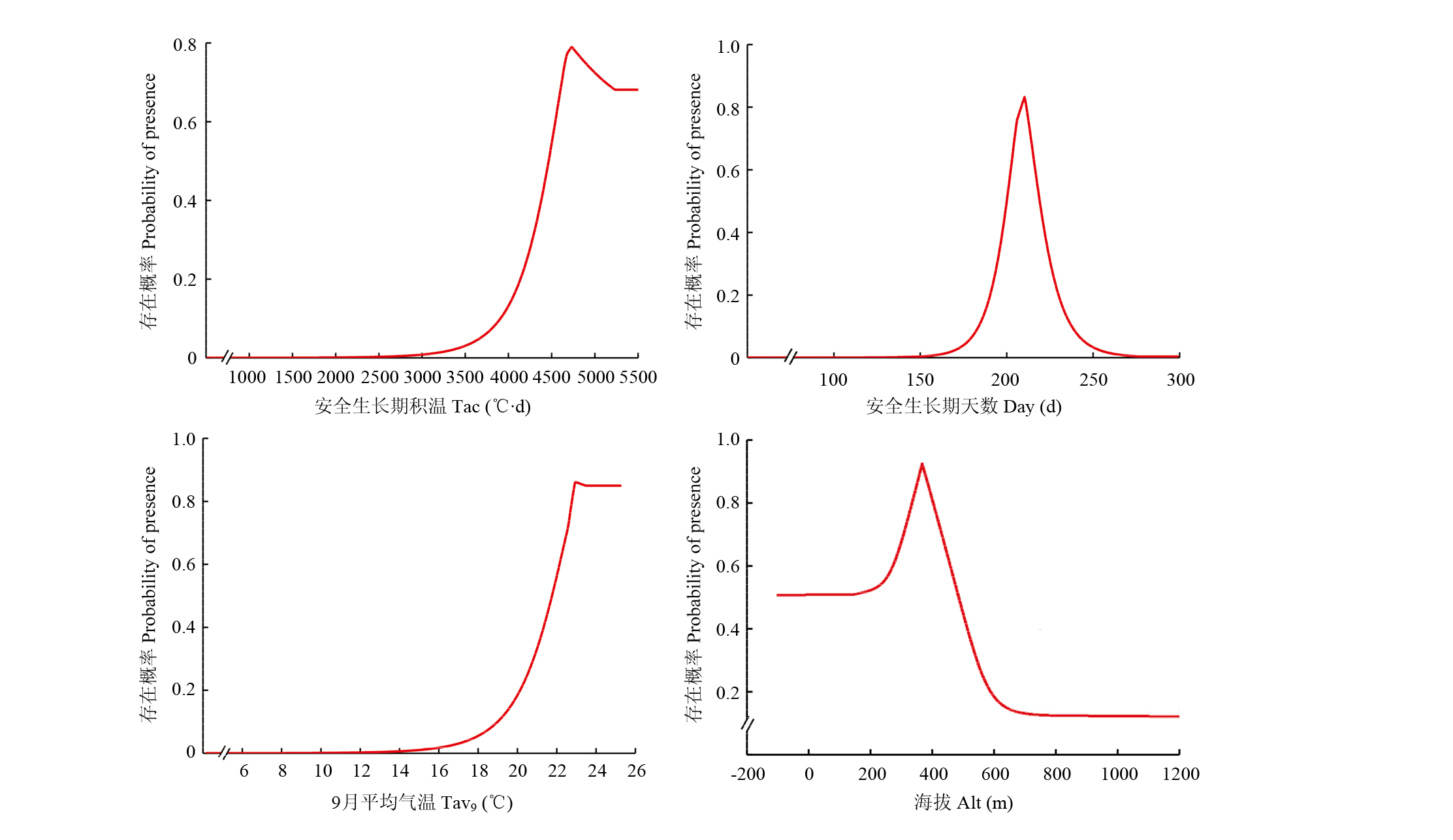
图5
再生稻存在概率对主导环境变量的响应曲线"

图6
过去(a)与当前(b)时期下再生稻种植区与潜在适宜区分布"
表2
过去与当前时期下再生稻种植区与潜在适宜区面积"
| 时期 Period | 种植区 Plant area | 潜在适宜区 Potential suitable area | |||
|---|---|---|---|---|---|
| 总适宜区 Total suitable | 高适宜区 Highly suitable | 中适宜区 Moderately suitable | 低适宜区 Lowly suitable | ||
| 过去 Past | 0.26 | 2.02 | 0.33 | 0.71 | 0.98 |
| 当前 Current | 0.44 | 3.25 | 0.84 | 1.12 | 1.29 |
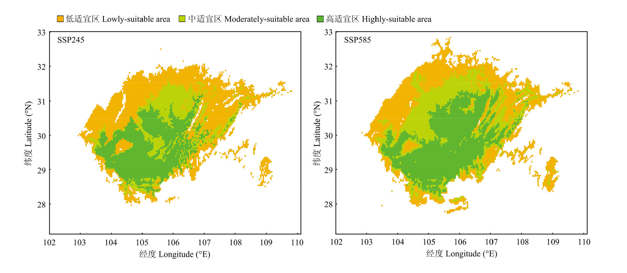
图7
未来气候变化情景下再生稻潜在适宜区分布"
表3
未来气候变化情景下再生稻潜在适宜区面积"
| 时期 Period | 气候情景 Climate type | 潜在适宜区 Potential suitable area | |||
|---|---|---|---|---|---|
| 总适宜区 Total suitable | 高适宜区 Highly suitable | 中适宜区 Moderately suitable | 低适宜区 Lowly suitable | ||
| 未来 Future | SSP245 | 3.37 | 1.12 | 0.70 | 1.56 |
| SSP585 | 3.80 | 1.54 | 0.98 | 1.27 | |
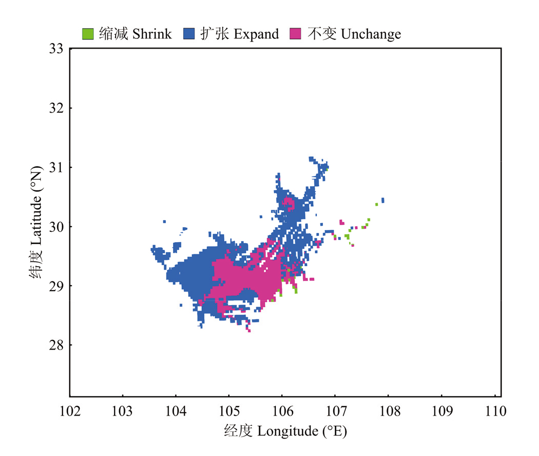
图8
过去至当前气候变化情景下再生稻高适宜区分布格局变迁"
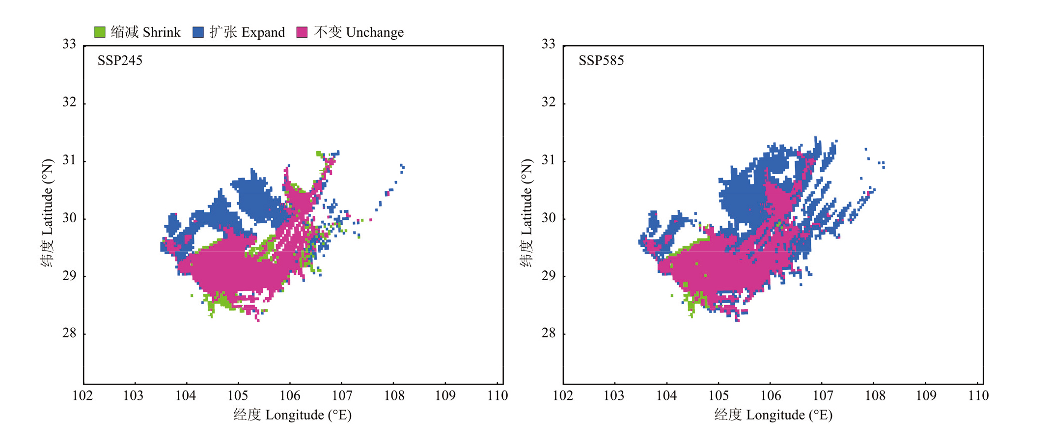
图9
当前至未来气候变化情景下再生稻高适宜区分布格局变迁"
表4
全球气候变化情景下不同时期之间再生稻高适宜区面积变化"
| 时期 Period | 高适宜区面积变化 Changes in the area of high suitability zones | |||
|---|---|---|---|---|
| 总变化 Total | 扩张 Expansion | 不变 Unchange | 缩减 Contraction | |
| 过去—当前 Past-current | 0.51(154.55%) | 0.52(157.57%) | 0.32(96.96%) | 0.01(3.03%) |
| 当前—SSP245 Current-SSP245 | 0.28(33.33%) | 0.38(45.24%) | 0.74(88.10%) | 0.10(11.91%) |
| 当前—SSP585 Current-SSP585 | 0.70(62.50%) | 0.73(65.18%) | 0.81(72.32%) | 0.03(2.68%) |
| [1] |
doi: 10.1016/j.fcr.2019.02.004 pmid: 31007365 |
| [2] |
郭文韬. 略论中国再生稻的历史发展. 中国农史, 1993, 12(4): 1-6.
|
|
|
|
| [3] |
冯宇鹏, 刘阿康, 陈丹阳, 贺娟, 梁健, 万克江, 鄂文弟. 新时期我国再生稻生产形势及对策建议. 中国稻米, 2025, 31(4): 5-8, 18.
|
|
doi: 10.3969/j.issn.1006-8082.2025.04.002 |
|
| [4] |
doi: 10.1016/j.apgeog.2022.102822 |
| [5] |
林文雄, 翁佩莹, 林文芳, 邵彩虹, 郭春林, 李忠, 陈鸿飞, 陈婷. 中国机收再生稻研究现状与展望. 应用生态学报, 2024, 35(3): 827-836.
doi: 10.13287/j.1001-9332.202403.008 |
|
|
|
| [6] |
徐富贤, 袁驰, 王学春, 韩冬, 廖爽, 曾正明, 曹厚明, 郭晓艺. 川南杂交中稻-再生稻高产品种产量形成特点. 核农学报, 2022, 36(9): 1849-1859.
doi: 10.11869/j.issn.100-8551.2022.09.1849 |
|
doi: 10.11869/j.issn.100-8551.2022.09.1849 |
|
| [7] |
IPCC. Climate change 2021: The physical science basis, the Working Group I contribution to the sixth assessment report. Cambridge: Cambridge University Press. https://www.ipcc.ch/report/ar6/wg1/.
|
| [8] |
郭建平. 气候变化对中国农业生产的影响研究进展. 应用气象学报, 2015, 26(1): 1-11.
|
|
|
|
| [9] |
吴建国, 吕佳佳, 艾丽. 气候变化对生物多样性的影响: 脆弱性和适应. 生态环境学报, 2009, 18(2): 693-703.
doi: 10.16258/j.cnki.1674-5906(2009)02-0693-11 |
|
|
|
| [10] |
王文强, 杨博, 李小伟, 梁咏亮, 李静尧. 未来气候变化对中国沙棘潜在地理分布的影响. 应用生态学报, 2024, 35(10): 2813-2821.
doi: 10.13287/j.1001-9332.202410.025 |
|
|
|
| [11] |
孙晓辉. 中国的再生稻研究. 四川农业大学学报, 1995, 13(4): 506-517.
|
|
|
|
| [12] |
李实蒉, 杨明均, 崔明新. 四川省再生稻种植区划初探. 西南农业学报, 1989, 2(2): 1-6.
|
|
|
|
| [13] |
四川省气象局农气中心再生稻课题组. 四川盆地再生稻气候生态条件分析及适宜种植区研究. 高原山地气象研究, 1990, 10(4): 25-32.
|
|
Sichuan Provincial Meteorological Bureau Agricultural Meteorology Center Regenerated Rice Research Group. Analysis of climatic and ecological conditions of ratooning rice in Sichuan basin and study on suitable planting areas. Plateau and Mountain Meteorology Research, 1990, 10(4): 25-32. (in Chinese)
|
|
| [14] |
高阳华, 易新民. 四川盆地再生稻气候生态类型区划. 资源开发与保护, 1991, 7(4): 264-265, 274.
|
|
|
|
| [15] |
张秀霞, 邓灵芝, 李旺平, 张喜来, 汪孝贤, 林庆润, 程小强. 基于农作物物候特征的干旱区撂荒耕地识别: 以甘肃省凉州区为例. 农业资源与环境学报, 2025, 42(3): 568-579.
|
|
|
|
| [16] |
吕子鹤, 丁松爽, 卢瑞琳. 中国农作物气候适宜性研究进展. 中国农学通报, 2020, 36(24): 78-84.
doi: 10.11924/j.issn.1000-6850.casb20190700470 |
|
doi: 10.11924/j.issn.1000-6850.casb20190700470 |
|
| [17] |
杨佳悦, 丁国玉, 田秀君. 最大熵模型在物种生境预测中的应用研究进展. 应用生态学报, 2025, 36(2): 614-624.
doi: 10.13287/j.1001-9332.202502.025 |
|
doi: 10.13287/j.1001-9332.202502.025 |
|
| [18] |
高阳华, 冉荣生, 唐云辉, 易新民. 重庆市再生稻气候生态条件及类型区划. 山区开发, 2003(2): 39-41.
|
|
|
|
| [19] |
张东方, 张琴, 郭杰, 孙成忠, 吴杰, 聂祥, 谢彩香. 基于MaxEnt模型的当归全球生态适宜区和生态特征研究. 生态学报, 2017, 37(15): 5111-5120.
|
|
|
|
| [20] |
周天军, 邹立维, 陈晓龙. 第六次国际耦合模式比较计划(CMIP6)评述. 气候变化研究进展, 2019, 15(5): 445-456.
|
|
|
|
| [21] |
王运生, 谢丙炎, 万方浩, 肖启明, 戴良英. ROC曲线分析在评价入侵物种分布模型中的应用. 生物多样性, 2007, 15(4): 365-372.
doi: 10.1360/biodiv.060280 |
|
doi: 10.1360/biodiv.060280 |
|
| [22] |
IPCC. Climate Change 2007:Synthesis Report. Contribution of Working Groups Ⅰ, Ⅱ and Ⅲ to the Fourth Assessment. Report of the Intergovernmental Panel on Climate Change. Geneva: IPCC, 2007. https://www.ipcc.ch/report/ar4/syr/.
|
| [23] |
罗伟, 朱玉璘, 李昱锐, 王玲玲, 欧奕含, 王茹琳. 气候变化背景下桔小实蝇在中国的潜在适生区预测. 应用与环境生物学报, 2024, 30(5): 959-966.
|
|
|
|
| [24] |
钟顺清, 孔晓谦. 富顺再生稻的发展与展望. 四川农业与农机, 2020(3): 49-50.
|
|
|
|
| [25] |
高亮之, 李林, 郭鹏. 中国水稻生长季与稻作制度的气候生态研究. 农业气象, 1983, 4(1): 50-55.
|
|
|
|
| [26] |
叶清, 杨晓光, 解文娟, 李勇, 刘子琪, 董朝阳, 孙爽. 气候变暖背景下中国南方水稻生长季可利用率变化趋势. 中国农业科学, 2013, 46(21): 4399-4415. doi:10.3864/j.issn.0578-1752.2013.21.002.
|
|
|
|
| [27] |
方文, 罗文质, 张景国, 熊洪, 江世华, 徐世华. 四川再生稻的生态条件及区域适应性研究. 西南农业学报, 1994, 7(3): 15-22.
|
|
|
|
| [28] |
徐富贤, 袁驰, 王学春, 韩冬, 廖爽, 张志勇, 陈琨, 曾世清, 孔晓谦, 曾正明, 等. 四川盆地东南部再生稻开花期受低温冷害的风险预测. 中国稻米, 2023, 29(1): 92-97, 102.
doi: 10.3969/j.issn.1006-8082.2023.01.015 |
|
doi: 10.3969/j.issn.1006-8082.2023.01.015 |
|
| [29] |
方文, 熊洪, 姚文力. 提高再生稻产量的气象条件探讨. 中国农业气象, 1990, 11(1): 35-38.
|
|
|
|
| [30] |
何燕, 李政, 廖雪萍, 孙涵. GIS支持下的巴西陆稻IAPAR-9再生稻合理布局气候区划. 中国农业气象, 2006, 27(4): 310-313, 334.
|
|
|
|
| [31] |
高阳华, 陈志军, 杨世琦, 唐云辉, 袁德胜. 基于GIS的重庆市再生稻光热资源适宜性区划. 长江流域资源与环境, 2011, 20(6): 672-676.
|
|
|
|
| [32] |
王贵学, 黄友钦, 陈国惠, 张洪, 刘仕琳. 湖北省再生稻气候生态区区划研究. 西南农业大学学报, 1995, 17(3): 202-206.
|
|
|
|
| [33] |
陈国惠, 张洪, 王贵学, 任昌福, 黄友钦, 刘仕琳, 庞江春. 云南省再生稻种植气候生态区划. 西南农业大学学报(自然科学版), 1994(4): 390-395.
|
|
|
|
| [34] |
郭翔, 胡蓉, 李旭毅. 近50年四川盆区再生稻气候适宜区时空分布特征. 生态学杂志, 2025, 44(5): 1653-1661.
|
|
doi: 10.13292/j.1000-4890.202505.015 |
|
| [35] |
宋开付, 张广斌, 徐华, 马静. 中国再生稻种植的影响因素及可持续性研究进展. 土壤学报, 2020, 57(6): 1365-1377.
|
|
|
|
| [36] |
徐富贤, 袁驰, 王学春, 韩冬, 廖爽, 陈勇, 周兴兵, 江青山, 张林, 蒋鹏. 不同杂交中稻品种在川南再生稻区的两季产量及头季稻米品质差异. 中国生态农业学报(中英文), 2020, 28(7): 990-998.
|
|
|
|
| [37] |
熊洪, 冉茂林, 徐富贤, 洪松. 南方稻区再生稻研究进展及发展. 作物学报, 2000, 26(3): 297-304.
|
|
|
|
| [38] |
罗孳孳, 方立魁, 武强, 韩旭, 李月臣, 朱玉涵, 陈欢, 张悦, 阳园燕. 四川盆地东部再生稻高温伏旱区腋芽萌发期气象适宜度. 气象, 2024, 50(4): 461-474.
|
|
|
|
| [39] |
林志敏, 李洲, 翁佩莹, 吴冬青, 邹京南, 庞孜钦, 林文雄. 再生稻田温室气体排放特征及碳足迹. 应用生态学报, 2022, 33(5): 1340-1351.
doi: 10.13287/j.1001-9332.202205.013 |
|
|
|
| [40] |
李俊材. 耐热及强再生力水稻品种筛选鉴定及其生理机理研究[D]. 长春: 吉林农业大学, 2023.
|
|
|
|
| [41] |
曹玉贤, 朱建强, 侯俊. 中国再生稻的产量差及影响因素. 中国农业科学, 2020, 53(4): 707-724. doi:10.3864/j.issn.0578-1752.2020.04.004.
|
|
|
|
| [42] |
郭翔, 胡蓉, 王明田, 李旭毅. 气候变暖背景下四川盆区再生稻适栽区变化. 核农学报, 2025, 39(4): 846-855.
doi: 10.11869/j.issn.1000-8551.2025.04.0846 |
|
doi: 10.11869/j.issn.1000-8551.2025.04.0846 |
|
| [43] |
段里成, 郭瑞鸽, 蔡哲, 林志坚, 吴自明, 方圣, 张崇华, 刘丹. 南方九省再生稻安全生长期及高温热害时空变化. 中国生态农业学报(中英文), 2021, 29(12): 2061-2073.
|
|
|
|
| [44] |
徐富贤, 熊洪, 张林, 朱永川, 蒋鹏, 郭晓艺, 刘茂. 再生稻产量形成特点与关键调控技术研究进展. 中国农业科学, 2015, 48(9): 1702-1717. doi:10.3864/j.issn.0578-1752.2015.09.04.
|
|
|
|
| [45] |
肖无为, 朱辰光, 王飞, 熊栋梁, 黄见良, 彭少兵, 崔克辉. 再生稻稻米品质研究进展. 中国水稻科学, 2025, 39(1): 33-46.
doi: 10.16819/j.1001-7216.2025.240412 |
|
doi: 10.16819/j.1001-7216.2025.240412 |
|
| [46] |
李谢辉, 刘子堂. 四川盆地极端气温事件时空变化特征及未来趋势. 水土保持研究, 2023, 30(1): 264-273.
|
|
|
|
| [47] |
罗伟, 梅岫峰, 李强, 李钰春, 张凯, 李昱锐. 气候变化对川渝地区再生稻产业的影响与建议: 以富顺县为例. 中国稻米, 2024, 30(4): 70-74.
|
|
doi: 10.3969/j.issn.1006-8082.2024.04.013 |
|
| [48] |
彭国照, 邢开瑜. 四川盆区近50年的水稻气候资源变化特征. 贵州农业科学, 2017, 45(4): 128-133.
|
|
|
|
| [49] |
赵锦, 杨晓光, 刘志娟, 成迪芳, 王文峰, 陈阜. 全球气候变暖对中国种植制度可能影响Ⅱ.南方地区气候要素变化特征及对种植制度界限可能影响. 中国农业科学, 2010, 43(9): 1860-1867. doi:10.3864/j.issn.0578-1752.2010.09.012.
|
|
|
|
| [50] |
杨德生, 黄见良, 彭少兵. 机收再生稻高产优质栽培技术研究进展. 中国稻米, 2023, 29(5): 1-8.
doi: 10.3969/j.issn.1006-8082.2023.05.001 |
|
doi: 10.3969/j.issn.1006-8082.2023.05.001 |
|
| [51] |
doi: 10.1016/j.agrformet.2018.09.010 |
| [52] |
刘丹, 田俊, 段里成. 气候变暖背景下江西省稻油轮作模式中的水稻种植结构变化. 中国生态农业学报(中英文), 2025, 33(4): 682-693.
|
|
|
|
| [53] |
彭少兵. 对转型时期水稻生产的战略思考. 中国科学: 生命科学, 2014, 44(8): 845-850.
|
|
|
|
| [54] |
罗孳孳, 张德军, 陈东东, 毕淼, 朱玉涵, 韩旭, 武强, 李月臣. 1981—2022年四川盆地再生稻抽穗灌浆期热量资源时空演变特征. 中国水稻科学, 2025, 39(6): 873-886.
doi: 10.16819/j.1001-7216.2025.240614 |
|
|
|
| [55] |
张巫军, 段秀建, 姚雄, 刘强明, 肖人鹏, 张现伟, 唐永群, 李经勇. 头季稻刈割时间对饲草产量、品质和再生稻产量的影响. 作物研究, 2023, 37(2): 110-115.
|
|
|
|
| [56] |
张巫军, 段秀建, 姚雄, 刘强明, 肖人鹏, 张现伟, 唐永群, 李经勇. 饲草—再生稻模式种植关键技术及效益分析. 南方农业, 2023, 17(7): 176-179.
|
|
|
| [1] | 郭世博, 张镇涛, 郭尔静, 赵锦, 刘志娟, 赵闯, 杨晓光. 全球气候变暖对中国种植制度的可能影响XV.适应未来气候变化的我国油料作物种植布局调整[J]. 中国农业科学, 2025, 58(11): 2118-2144. |
| [2] | 邹恒宇, 郭熙, 江叶枫, 李小毛, 陈琳, 白家奇. 基于生态位模型的地理标志农产品种植适宜性评价研究——以上高县紫皮大蒜为例[J]. 中国农业科学, 2024, 57(18): 3586-3600. |
| [3] | 杨王华, 刘志娟, 巩敬锦, 付真真, 张太林, 张晓龙, 沈彦军, 杨晓光. 东北地区未来春玉米干旱风险时空分布及对气候变化的响应[J]. 中国农业科学, 2024, 57(12): 2336-2349. |
| [4] | 张卫建, 尚子吟, 张俊, 严圣吉, 邓艾兴, 张鑫, 郑成岩, 宋振伟. 农业温室气体排放统计核算体系的规范化建设[J]. 中国农业科学, 2023, 56(22): 4467-4477. |
| [5] | 史鑫蕊, 韩百书, 王紫芊, 张媛铃, 李萍, 宗毓铮, 张东升, 高志强, 郝兴宇. 基于APSIM模型模拟分析气候变化对不同熟性北方冬小麦生长和产量的影响[J]. 中国农业科学, 2023, 56(19): 3772-3787. |
| [6] | 张志良, 和志豪, 茹晓雅, 蒋腾聪, 何英彬, 冯浩, 于强, 何建强. 未来气候变化对中国马铃薯种植气候适宜性的影响[J]. 中国农业科学, 2023, 56(18): 3530-3542. |
| [7] | 张文婧, 赵锦, 崔文倩, 黎满耀, 李娥, 弓晓雅, 杨晓光. 气候平均态和极端态变化对东北玉米气象产量的影响[J]. 中国农业科学, 2023, 56(10): 1859-1870. |
| [8] | 赵政鑫,王晓云,田雅洁,王锐,彭青,蔡焕杰. 未来气候条件下秸秆还田和氮肥种类对夏玉米产量及土壤氨挥发的影响[J]. 中国农业科学, 2023, 56(1): 104-117. |
| [9] | 郭世博, 张方亮, 张镇涛, 周丽涛, 赵锦, 杨晓光. 全球气候变暖对中国种植制度的可能影响XIV.东北大豆高产稳产区及农业气象灾害分析[J]. 中国农业科学, 2022, 55(9): 1763-1780. |
| [10] | 任义方,杨章平,零丰华,肖良文. 江苏奶牛热应激风险区划及其受气候变化的影响[J]. 中国农业科学, 2022, 55(22): 4513-4525. |
| [11] | 相玉婷, 王晓龙, 胡新中, 任长忠, 郭来春, 李璐. 燕麦品种间脂肪酶活性差异及低脂肪酶优质品种的预测[J]. 中国农业科学, 2022, 55(21): 4104-4117. |
| [12] | 李博,杨帆,秦琴,钟晓媛,李秋萍,曾玉玲,卢慧,陈勇,王丽,陶有凤,李娟,冯炳亮,任万军,邓飞. 播期对再生稻次适宜区杂交籼稻食味品质的影响[J]. 中国农业科学, 2022, 55(1): 36-50. |
| [13] | 唐建昭,王靖,肖登攀,潘学标. 马铃薯生长模型的研究进展及发展前景[J]. 中国农业科学, 2021, 54(5): 921-932. |
| [14] | 张卫建, 严圣吉, 张俊, 江瑜, 邓艾兴. 国家粮食安全与农业双碳目标的双赢策略[J]. 中国农业科学, 2021, 54(18): 3892-3902. |
| [15] | 房蕊,于镇华,李彦生,谢志煌,刘俊杰,王光华,刘晓冰,陈渊,刘居东,张少庆,吴俊江,Stephen J HERBERT,金剑. 大气CO2浓度和温度升高对农田土壤碳库及微生物群落结构的影响[J]. 中国农业科学, 2021, 54(17): 3666-3679. |
|
||