


中国农业科学 ›› 2020, Vol. 53 ›› Issue (24): 5005-5016.doi: 10.3864/j.issn.0578-1752.2020.24.004
奚雪1( ),赵庚星1(),高鹏1,崔昆1,李涛2
收稿日期:2020-03-07
接受日期:2020-05-05
出版日期:2020-12-16
发布日期:2020-12-28
通讯作者:
赵庚星
作者简介:奚雪,E-mail: 基金资助:
XI Xue1(),ZHAO GengXing1(),GAO Peng1,CUI Kun1,LI Tao2
Received:2020-03-07
Accepted:2020-05-05
Online:2020-12-16
Published:2020-12-28
Contact:
GengXing ZHAO
摘要:
【目的】探究黄河三角洲麦田土壤盐分准确高效的遥感提取方法,掌握土壤盐渍化程度与分布。【方法】以垦利区为研究区,均匀布设冬小麦种植区样点77个,同时设置代表性试验区2个,网格布设样点99个,实测采集麦田土壤表层盐分数据及试验区无人机多光谱图像。筛选红、绿、红边、近红4个波段及SI、NDVI、DVI、RVI、GRVI 5个光谱指数中的敏感光谱参量,采用逐步回归、偏最小二乘法、BP神经网络及SVM支持向量机4种方法建立土壤盐分估测模型,使用波段比值均值法得到Sentinel-2A卫星影像相应波段的修正系数,进而将筛选的土壤盐分估测模型转换为基于卫星影像的反演模型,经麦区实测样点数据验证,得到最佳的麦区土壤盐分反演模型,实现试验区和研究区2个尺度的麦田土壤盐分反演。【结果】无人机4个波段及光谱指数NVDI、RVI、SI与土壤盐分含量相关性显著,4种建模方法的13个模型中,以NDVI、RVI、SI建立的4个指数模型的建模及验证R2均优于其他模型;对4个模型进行升尺度修正及验证,效果最佳的反演模型为偏最小二乘法光谱指数模型:Y=-9.4774×NDVI1+0.4794×RVI1+3.0747×SI1+5.0604,验证R2为0.513,RMSE为1.379;利用该模型反演得到了试验区及整个研究区麦田土壤盐分等级分布图,结合实测插值及调查结果,证明反演模型及空间分布结果准确、可靠。【结论】本研究构建了卫星、无人机一体化的滨海麦区土壤盐分反演模型,对滨海盐渍区农作物的生产管理有积极参考价值。
奚雪,赵庚星,高鹏,崔昆,李涛. 基于Sentinel卫星及无人机多光谱的滨海冬小麦种植区土壤盐分反演研究——以黄三角垦利区为例[J]. 中国农业科学, 2020, 53(24): 5005-5016.
XI Xue,ZHAO GengXing,GAO Peng,CUI Kun,LI Tao. Inversion of Soil Salinity in Coastal Winter Wheat Growing Area Based on Sentinel Satellite and Unmanned Aerial Vehicle Multi-Spectrum— A Case Study in Kenli District of the Yellow River Delta[J]. Scientia Agricultura Sinica, 2020, 53(24): 5005-5016.
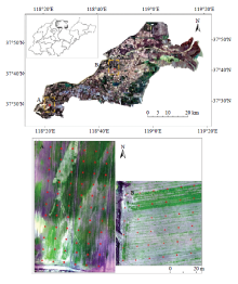
图1
研究区及试验区分布图"
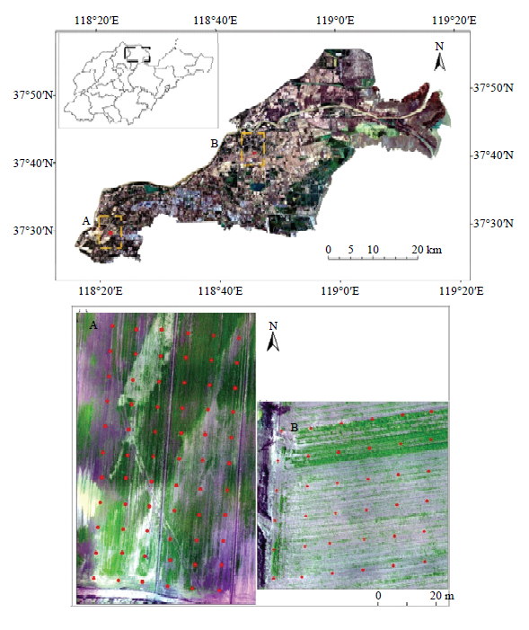
表1
光谱指数计算公式"
| 光谱指数 Spectral index | 计算公式 Computational formula | 参考文献 Reference |
|---|---|---|
| 归一化植被指数NDVI | (bNIR-bR)/( bNIR+bR) | [32] |
| 比值植被指数RVI | bNIR/bR | [32] |
| 差值植被指数DVI | bNIR-bR | [32] |
| 绿波段比值植被指数GRVI | bNIR/bG | [32] |
| 盐分指数SI | $\sqrt{bG\times bR}$ | [33] |
表2
垦利区土壤盐渍化程度分级标准"
| 土壤盐渍化等级 Soil salinity grade | 非盐渍化 Non-salinized | 轻度盐渍化 Mild salinized | 中度盐渍化 Moderate salinized | 重度盐渍化 Severe salinized | 盐土 Salinized soil |
|---|---|---|---|---|---|
| 分级标准 Grade standard (g·kg-1) | SS<1 | 1≤SS<2 | 2≤SS<4 | 4≤SS<6 | SS>6 |
| 等级 Grade | 1 | 2 | 3 | 4 | 5 |
表3
试验区样点各波段与实测土壤盐分含量相关性"
| 变量 Variable | SS | G | R | REG | NIR |
|---|---|---|---|---|---|
| SS | 1 | ||||
| G | 0.677** | 1 | |||
| R | 0.667** | 0.506** | 1 | ||
| REG | 0.616** | 0.431** | 0.578** | 1 | |
| NIR | -0.671** | -0.561** | -0.449** | -0.486** | 1 |
表4
试验区样点光谱指数与实测土壤盐分含量相关性"
| 变量 Variable | SS | SI | NDVI | DVI | RVI | GRVI |
|---|---|---|---|---|---|---|
| SS | 1 | |||||
| SI | 0.770** | 1 | ||||
| NDVI | -0.787** | -0.808** | 1 | |||
| DVI | -0.780** | -0.768** | 0.953** | 1 | ||
| RVI | -0.560** | -0.696** | 0.890** | 0.844** | 1 | |
| GRVI | -0.432** | -0.690** | 0.468** | 0.557** | 0.398** | 1 |
表5
基于无人机多光谱的土壤盐分估测模型"
| 建模方法 Modeling approach | 光谱参量 Spectral parameter | 估测模型 Estimating model | 建模精度 Modeling accuracy | 验证精度 Verification accuracy | ||
|---|---|---|---|---|---|---|
| R2 | RMSE | R2 | RMSE | |||
| 逐步回归 Stepwise regression | bG | Y=18.609×bG+0.169 | 0.458 | 1.267 | 0.401 | 0.882 |
| bG,bR | Y=12.546×bG+19.044×bR-1.120 | 0.599 | 1.089 | 0.600 | 0.729 | |
| bG,bR,bNIR | Y=8.360×bG+15.775×bR-9.912×bNIR +3.116 | 0.673 | 0.983 | 0.650 | 0.847 | |
| bG,bR,bNIR,bREG | Y=7.988×bG+12.282×bR-8.525×bNIR+6.979×bREG+2.101 | 0.694 | 0.951 | 0.648 | 0.771 | |
| NDVI | Y=-7.507×NDVI+6.308 | 0.620 | 1.061 | 0.668 | 0.685 | |
| NDVI,RVI | Y=-13.261×NDVI+0.69×RVI+6.734 | 0.715 | 0.918 | 0.692 | 0.897 | |
| NDVI,RVI,SI | Y=-10.287×NDVI+0.651×RVI+13.486×SI+3.843 | 0.756 | 0.850 | 0.710 | 0.907 | |
| 偏最小二乘法 Partial least squares | bG,bR,bNIR,bREG | Y=6.021×bG+6.5986×bR+6.2650×bNIR-4.1737×bREG+1.3260 | 0.689 | 1.114 | 0.719 | 1.177 |
| NDVI,RVI,SI | Y=-9.4774×NDVI+0.4794×RVI+3.0747×SI+5.0604 | 0.734 | 0.954 | 0.784 | 0.769 | |
| BP神经网络 The BP neural network | bG,bR,bNIR,bREG | — | — | — | 0.714 | 0.893 |
| NDVI,RVI,SI | — | — | — | 0.753 | 0.993 | |
| 支持向量机 Support vector machine | bG,bR,bNIR,bREG | — | 0.804 | 0.590 | 0.467 | 0.473 |
| NDVI,RVI,SI | — | 0.835 | 0.353 | 0.640 | 0.512 | |
表6
基于卫星影像光谱指数的土壤盐分估测模型"
| 建模方法 Modeling approach | 估测模型 Estimating model | 建模精度 Modeling accuracy | 验证精度 Verification accuracy | ||
|---|---|---|---|---|---|
| R2 | RMSE | R2 | RMSE | ||
| 逐步回归Stepwise regression | Y=-97.012×NDVI+22.298×RVI-13.905×SI-8.489 | 0.509 | 1.190 | 0.434 | 0.874 |
| 偏最小二乘法Partial least squares | Y=-57.4889×NDVI+13.3418×RVI+21.9667×SI-9.0323 | 0.555 | 0.940 | 0.414 | 0.964 |
| BP神经网络The BP neural network | — | — | — | 0.602 | 0.900 |
| 支持向量机Support vector machine | — | 0.612 | 1.166 | 0.438 | 0.432 |
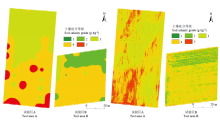
图2
试验区土壤盐分实测插值图(左)及反演图(右)"

表7
试验区土壤盐分等级面积统计"
| 土壤盐分等级分布图 Distribution diagram of soil salinity grade | 试验区A Test area A | 试验区B Test area B | ||||||||
|---|---|---|---|---|---|---|---|---|---|---|
| 1 | 2 | 3 | 4 | 5 | 1 | 2 | 3 | 4 | 5 | |
| 实测图Interpolation diagram | 0 | 0 | 47.63 | 36.16 | 16.21 | 32.74 | 0 | 9.81 | 57.45 | 0 |
| 反演图Inversion diagram | 0 | 0 | 47.34 | 36.38 | 16.28 | 31.27 | 7.84 | 8.10 | 50.63 | 2.16 |
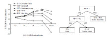
图3
研究区典型地物光谱曲线(左)及冬小麦决策树提取模型(右)"
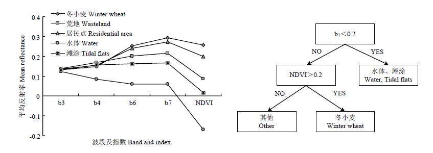
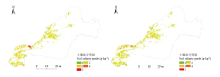
图4
麦区土壤盐分实测插值图(左)及升尺度反演图(右)"

表8
麦区土壤盐分等级面积统计"
| 土壤盐分等级分布图 Distribution diagram of soil salinity grade | 1 | 2 | 3 | 4 | 5 |
|---|---|---|---|---|---|
| 实测图Interpolation diagram | 0 | 63.07 | 18.28 | 14.45 | 4.20 |
| 反演图Inversion diagram | 0 | 73.09 | 14.01 | 10.08 | 2.82 |
| [1] | 王建华, 胡鹏, 龚家国. 实施黄河口大保护推动黄河流域生态文明建设. 人民黄河, 2019,41(10):7-10. |
| WANG J H, HU P, GONG J G. Taking the great protection of the Yellow River estuary as the grasp to promote the construction of ecological civilization in the Yellow River basin. Yellow River, 2019,41(10):7-10. (in Chinese) | |
| [2] | 刘丽娟, 李小玉. 干旱区土壤盐分积累过程研究进展. 生态学杂志, 2019,38(3):891-898. |
| LIU L J, LI X Y. Progress in the study of soil salt accumulation in arid region. Chinese Journal of Ecology, 2019,38(3):891-898. (in Chinese) | |
| [3] | 张顺, 贾永刚, 连胜利, 付腾飞, 潘玉英. 电导率法在土壤盐渍化中的改进和应用进展. 土壤通报, 2014,45(3):754-759. |
| ZHANG S, JIA Y G, LIAN S L, FU T F, PAN Y Y. Application and improvement of electrical conductivity measurements in soil salinity. Chinese Journal of Soil Science, 2014,45(3):754-759. (in Chinese) | |
| [4] | 阿尔达克·克里木, 塔西甫拉提·特依拜, 张东, 依力亚斯江·努尔麦麦提. 基于高光谱的ASTER影像土壤盐分模型校正及验证. 农业工程学报, 2016,32(12):144-150. |
| ARDAK K L M, TAXIPULAT T Y P, ZHANG D, ILYASJ N R M M T. Calibration and validation of soil salinity estimation model based on measured hyperspectral and Aster image. Transactions of the Chinese Society of Agricultural Engineering, 2016,32(12):144-150. (in Chinese) | |
| [5] | 吴亚坤, 刘广明, 苏里坦, 杨劲松. 多源数据的区域土壤盐渍化精确评估. 光谱学与光谱分析, 2018,38(11):3528-3533. |
| WU Y K, LIU G M, SU L T, YANG J S. Accurate evaluation of regional soil salinization using multi-source data. Spectroscopy and Spectral Analysis, 2018,38(11):3528-3533. (in Chinese) | |
| [6] | 胡盈盈, 王瑞燕, 陈红艳, 李玉萍, 刘燕群. 黄河三角洲春秋两季土壤盐分遥感反演及时空变异研究. 测绘与空间地理信息, 2018,41(8):78-81. |
| HU Y Y, WANG R Y, CHEN H Y, LI Y P, LIU Y Q. Research on remote sensing retrieval and temporal variation of soil salinity in the spring and autumn of the Yellow River Delta. Geomatics & Spatial Information Technology, 2018,41(8):78-81. (in Chinese) | |
| [7] |
SCUDIERO E, SKAGGS T H, CORWIN D L. Regional-scale soil salinity assessment using Landsat ETM+ canopy reflectance. Remote Sensing of Environment, 2015,169:335-343.
doi: 10.1016/j.rse.2015.08.026 |
| [8] | 梁静, 丁建丽, 王敬哲, 王飞. 基于反射光谱与 Landsat 8 OLI 多光谱数据的艾比湖湿地土壤盐分估算. 土壤学报, 2019,56(2):320-330. |
| LIANG J, DING J L, WANG J Z, WANG F. Quantitative estimationand mapping of soil salinity in the Ebinur Lake wetland based on Vis-NIR reflectance and Landsat 8 OLI data. Acta Pedologica Sinica, 2019,56(2):320-330. (in Chinese) | |
| [9] | 陈俊英, 王新涛, 张智韬, 韩佳, 姚志华, 魏广飞. 基于无人机-卫星遥感升尺度的土壤盐渍化监测方法. 农业机械学报, 2019,50(12):161-169. |
| CHEN J Y, WANG X T, ZHANG Z T, HAN J, YAO Z H, WEI G F. Soil salinization monitoring method based on UAV-satellite remote sensing scale-up. Transactions of the Chinese Society for Agricultural Machinery, 2019,50(12):161-169. (in Chinese) | |
| [10] |
ZHANG S M, ZHAO G X. A harmonious satellite-unmanned aerial vehicle-ground measurement inversion method for monitoring salinity in coastal saline soil. Remote Sensing, 2019,11(14):1700.
doi: 10.3390/rs11141700 |
| [11] | SONG C Y, REN H X, HUANG C. Estimating soil salinity in the Yellow River Delta, Eastern China—An integrated approach using spectral and terrain indices with the generalized additive model. Pedosphere, 2016, 26(5):626-635. |
| [12] |
贾吉超, 赵庚星, 高明秀, 王卓然, 常春艳, 姜曙千, 李晋. 黄河三角洲典型区域冬小麦播种面积变化与土壤盐分关系研究. 植物营养与肥料学报, 2015,21(5):1200-1208.
doi: 10.11674/zwyf.2015.0513 |
|
JIA J C, ZHAO G X, GAO M X, WANG Z R, CHANG C Y, JIANG S Q, LI J. Study on the relationship between winter wheat sowing area changes and soil salinity in the typical area of the Yellow River Delta. Journal of Plant Nutrition and Fertilizers, 2015,21(5):1200-1208. (in Chinese)
doi: 10.11674/zwyf.2015.0513 |
|
| [13] |
张同瑞, 赵庚星, 高明秀, 王卓然, 贾吉超, 李萍, 安德玉. 基于近地面多光谱的黄河三角洲典型地区土壤含盐量估算研究. 光谱学与光谱分析, 2016,36(1):248-253.
pmid: 27228776 |
|
ZHANG T R, ZHAO G X, GAO M X, WANG Z R, JIA J C, LI P, AN D Y. Soil salinity estimation based on near-ground multispectral imagery in typical area of the Yellow River Delta. Spectroscopy and Spectral Analysis, 2016,36(1):248-253. (in Chinese)
pmid: 27228776 |
|
| [14] |
ZHANG T T, ZENG S L, GAO Y, QUYANG Z T, LI B, FANG C M, ZHAO B. Using hyperspectral vegetation indices as a proxy to monitor soil salinity. Ecological Indicators, 2011,11(6):1552-1562.
doi: 10.1016/j.ecolind.2011.03.025 |
| [15] | 张天举, 陈永金, 刘加珍. 黄河三角洲湿地不同植物群落土壤盐分分布特征. 浙江农业学报, 2018,30(11):1915-1924. |
| ZHANG T J, CHEN Y J, LIU J Z. Characteristics of spatial distribution of soil salinity under different plant communities on wetland in Yellow River Delta. Acta Agriculturae Zhejiangensis, 2018,30(11):1915-1924. (in Chinese) | |
| [16] |
张雪妮, 吕光辉, 杨晓东, 贡璐, 秦璐, 何学敏, 刘昊奇. 基于盐分梯度的荒漠植物多样性与群落、种间联接响应. 生态学报, 2013,33(18):5714-5722.
doi: 10.5846/stxb201306071403 |
|
ZHANG X N, LÜ G H, YANG X D, GONG L, QIN L, HE X M, LIU H Q. Responses of desert plant diversity, community and interspecific association to soil salinity gradient. Acta Ecologica Sinica, 2013,33(18):5714-5722. (in Chinese)
doi: 10.5846/stxb201306071403 |
|
| [17] | 安德玉, 邢前国, 赵庚星. 基于HICO波段的滨海土壤盐分遥感反演研究. 海洋学报, 2018,40(6):51-59. |
| AN D Y, XING Q G, ZHAO G X. Hyperspectral remote sensing of soil salinity for coastal saline soil in the Yellow River Delta based on HICO bands. Acta Oceanologica Sinica, 2018,40(6):51-59. (in Chinese) | |
| [18] | 张素铭, 赵庚星, 王卓然, 肖杨, 郎坤. 滨海盐渍区土壤盐分遥感反演及动态监测. 农业资源与环境学报, 2018,35(4):349-358. |
| ZHANG S M, ZHAO G X, WANG Z R, XIAO Y, LANG K. Remote sensing inversion and dynamic monitoring of soil salt in coastal saline area. Journal of Agricultural Resources and Environment, 2018, 35(4):349-358. (in Chinese) | |
| [19] | 陈红艳, 赵庚星, 陈敬春, 王瑞燕, 高明秀. 基于改进植被指数的黄河口区盐渍土盐分遥感反演. 农业工程学报, 2015,31(5):107-114. |
| CHEN H Y, ZHAO G X, CHEN J C, WANG R Y, GAO M X. Remote sensing inversion of saline soil salinity based on modified vegetation index in estuary area of Yellow River. Transactions of the Chinese Society of Agricultural Engineering, 2015,31(5):107-114. (in Chinese) | |
| [20] | 周晓红, 张飞, 张海威, 张贤龙, 袁婕. 艾比湖湿地自然保护区土壤盐分多光谱遥感反演模型. 光谱学与光谱分析, 2019,39(4):12 29-1235. |
| ZHOU X H, ZHANG F, ZHANG H W, ZHANG X L, YUAN J. A study of soil salinity inversion based on multispectral remote sensing index in Ebinur Lake Wetland Nature Reserve. Spectroscopy and Spectral Analysis, 2019,39(4):1229-1235. (in Chinese) | |
| [21] | 张贤龙, 张飞, 张海威, 李哲, 海清, 陈丽华. 基于光谱变换的高光谱指数土壤盐分反演模型优选. 农业工程学报, 2018,34(1):110-117. |
| ZHANG X L, ZHANG F, ZHANG H W, LI Z, HAI Q, CHEN L H. Optimization of soil salt inversion model based on spectral transformation from hyperspectral index. Transactions of the Chinese Society of Agricultural Engineering, 2018,34(1):110-117. (in Chinese) | |
| [22] |
王丹阳, 陈红艳, 王桂峰, 丛津桥, 王向锋, 魏学文. 无人机多光谱反演黄河口重度盐渍土盐分的研究. 中国农业科学, 2019,52(10):1698-1709.
doi: 10.3864/j.issn.0578-1752.2019.10.004 |
|
WANG D Y, CHEN H Y, WANG G F, CONG J Q, WANG X F, WEI X W. Salinity inversion of severe saline soil in the Yellow River estuary based on UAV multi-spectra. Scientia Agricultura Sinica, 2019,52(10):1698-1709. (in Chinese)
doi: 10.3864/j.issn.0578-1752.2019.10.004 |
|
| [23] |
HAMZEH S, NASERI A A, ALAVIPANAH S K, MOJARADI B, BARTHOLOMEUS H M, CLEVERS J G P W, BEHZAD M. Estimating salinity stress in sugarcane fields with spaceborne hyperspectral vegetation indices. International Journal of Applied Earth Observation & Geoinformation, 2013,21:282-290.
doi: 10.1016/j.jag.2012.07.002 |
| [24] | 朱赟, 申广荣, 项巧巧, 吴裕. 基于不同光谱变换的土壤盐含量光谱特征分析. 土壤通报, 2017,48(3):560-568. |
| ZHU Y, SHEN G R, XIANG Q Q, WU Y. Spectral characteristics of soil salinity based on different pre-processing methods. Chinese Journal of Soil Science, 2017,48(3):560-568. (in Chinese) | |
| [25] | 姚远, 丁建丽, 张芳, 赵振亮, 江红南. 基于高光谱指数和电磁感应技术的区域土壤盐渍化监测模型. 光谱学与光谱分析, 2013,33(6):1658-1664. |
| YAO Y, DING J L, ZHANG F, ZHAO Z L, JIANG H N. Research on model of soil salinization monitoring based on hyperspectral index and EM38. Spectroscopy and Spectral Analysis, 2013,33(6):1658-1664. (in Chinese) | |
| [26] | 厉彦玲, 赵庚星, 常春艳, 王卓然, 王凌, 郑佳荣. OLI与HSI影像融合的土壤盐分反演模型. 农业工程学报, 2017,33(21):173-180. |
| LI Y L, ZHAO G X, CHENG C Y, WANG Z R, WANG L, ZHENG J R. Soil salinity retrieval model based on OLI and HSI image fusion. Transactions of the Chinese Society of Agricultural Engineering, 2017,33(21):173-180. (in Chinese) | |
| [27] | 冯娟, 丁建丽, 杨爱霞, 蔡亮红. 干旱区土壤盐渍化信息遥感建模. 干旱地区农业研究, 2018,36(1):266-273. |
| FENG J, DING J L, YANG A X, CAI L H. Remote sensing modeling of soil salinization information in arid areas. Agricultural Research in the Arid Areas, 2018,36(1):266-273. (in Chinese) | |
| [28] | 曹肖奕, 丁建丽, 葛翔宇, 王敬哲. 基于光谱指数与机器学习算法的土壤电导率估算研究. 土壤学报, 2020,56(4):867-877. |
| CAO X Y, DING J L, GE X Y, WANG J Z. Estimation of soil electrical conductivity based on spectral index and machine learning algorithm. Acta Pedologica Sinica, 2020,56(4):867-877. (in Chinese) | |
| [29] | 张智韬, 魏广飞, 姚志华, 谭丞轩, 王新涛, 韩佳. 基于无人机多光谱遥感的土壤含盐量反演模型研究. 农业机械学报, 2019,50(12):151-160. |
| ZHANG Z T, WEI G F, YAO Z H, TAN C X, WANG X T, HAN J. Soil salt inversion model based on UAV multispectral remote sensing. Transactions of the Chinese Society for Agricultural Machinery, 2019,50(12):151-160. (in Chinese) | |
| [30] | 林芬, 赵庚星, 常春艳, 王卓然, 李慧. 基于相邻轨道图像的冬小麦面积提取及长势分析. 农业资源与环境学报, 2016,33(4):384-389. |
| LIN F, ZHAO G X, CHANG C Y, WANG Z R, LI H. Extraction of winter wheat area and growth analysis based on remote sensing imagery of adjacent tracks. Journal of Agricultural Resources and Environment, 2016,33(4):384-389. (in Chinese) | |
| [31] |
王卓然, 赵庚星, 高明秀, 常春艳, 姜曙千, 贾吉超, 李晋. 黄河三角洲垦利县夏季土壤水盐空间变异及土壤盐分微域特征. 生态学报, 2016,36(4):1040-1049.
doi: 10.5846/stxb201406231296 |
|
WANG Z R, ZHAO G X, GAO M X, CHANG C Y, JIANG S Q, JIA J C, LI J. Spatial variation of soil water and salt and microscopic variation of soil salinity in summer in typical area of the Yellow River Delta in Kenli county. Acta Ecologica Sinica, 2016,36(4):1040-1049. (in Chinese)
doi: 10.5846/stxb201406231296 |
|
| [32] |
方孝荣, 高俊峰, 谢传奇, 朱逢乐, 黄凌霞, 何勇. 农作物冠层光谱信息检测技术及方法综述. 光谱学与光谱分析, 2015,35(7):1949-1955.
pmid: 26717758 |
|
FANG X R, GAO J F, XIE C Q, ZHU F L, HUANG L X, HE Y. Review of crop canopy spectral information detection technology and methods. Spectroscopy and Spectral Analysis, 2015,35(7):1949-1955 . (in Chinese)
pmid: 26717758 |
|
| [33] | DOUAOUI A E K, NICOLAS H, WALTER C. Detecting salinity hazards within a semiarid context by means of combining soil and remote-sensing data. Geoderma, 2006,134(1/2):217-230. |
| [34] | 鲍士旦. 土壤农化分析. 北京: 中国农业出版社, 2000. |
| BAO S D. Soil and Agricultural Chemistry Analysis. Beijing: China Agricultural Press, 2000. (in Chinese) | |
| [35] | NGUYEN K A, LIOU Y A, TRAN H, HOANG P P, NGUYEN T H. Soil salinity assessment by using nearinfrared channel and vegetation soil salinity index derived from Landsat 8 OLI data: A case study in the Tra Vinh province, Mekong Delta, Vietnam. Progress Earth and Planetary Science, 2020,7(1). |
| [36] |
ALLBED A, KUMAR L, ALDAKHEEL Y Y. Assessing soil salinity using soil salinity and vegetation indices derived from IKONOS high-spatial resolution imageries: Applications in a date palm dominated region. Geoderma, 2014,230/231:1-8.
doi: 10.1016/j.geoderma.2014.03.025 |
| [37] | 葛哲学, 孙志强. 神经网络理论与MATLAB R2007实现. 北京: 电子工业出版社, 2005. |
| GE Z X, SUN Z Q. Neural Network Theory and MATLAB R2007 Realization. Beijing: Publishing House of Electronics Industry, 2005. (in Chinese) | |
| [38] | 丁世飞, 齐丙娟, 谭红艳. 支持向量机理论与算法研究综述. 电子科技大学学报, 2011,40(1):2-10. |
| DING S F, QI B J, TAN H Y. An overview on theory and algorithm of support vector machines. Journal of University of Electronic Science and Technology of China, 2011,40(1):2-10. (in Chinese) |
| [1] | 徐久凯, 袁亮, 温延臣, 张水勤, 李燕婷, 李海燕, 赵秉强. 畜禽有机肥氮在冬小麦季对化肥氮的相对替代当量[J]. 中国农业科学, 2023, 56(2): 300-313. |
| [2] | 王洋洋,刘万代,贺利,任德超,段剑钊,胡新,郭天财,王永华,冯伟. 基于多元统计分析的小麦低温冻害评价及水分效应差异研究[J]. 中国农业科学, 2022, 55(7): 1301-1318. |
| [3] | 冯子恒,宋莉,张少华,井宇航,段剑钊,贺利,尹飞,冯伟. 基于无人机多光谱和热红外影像信息融合的小麦白粉病监测[J]. 中国农业科学, 2022, 55(5): 890-906. |
| [4] | 王淑婷,孔雨光,张赞,陈红艳,刘鹏. 基于星-机光谱融合的棉花叶片SPAD值反演[J]. 中国农业科学, 2022, 55(24): 4823-4839. |
| [5] | 伊英杰,韩坤,赵斌,刘国利,林佃旭,陈国强,任昊,张吉旺,任佰朝,刘鹏. 长期不同施肥措施冬小麦-夏玉米轮作体系周年氨挥发损失的差异[J]. 中国农业科学, 2022, 55(23): 4600-4613. |
| [6] | 马啸,陈鹏飞. 基于无人机多光谱影像的小麦封垄前种植行识别方法改进[J]. 中国农业科学, 2022, 55(20): 3926-3938. |
| [7] | 刘丰,蒋佳丽,周琴,蔡剑,王笑,黄梅,仲迎鑫,戴廷波,曹卫星,姜东. 美国软麦籽粒品质变化趋势及对我国弱筋小麦标准达标度分析[J]. 中国农业科学, 2022, 55(19): 3723-3737. |
| [8] | 韩守威,司纪升,余维宝,孔令安,张宾,王法宏,张海林,赵鑫,李华伟,孟鈺. 山东省冬小麦产量差与氮肥利用效率差形成机理解析[J]. 中国农业科学, 2022, 55(16): 3110-3122. |
| [9] | 孟雨,温鹏飞,丁志强,田文仲,张学品,贺利,段剑钊,刘万代,冯伟. 基于热红外图像的小麦品种抗旱性鉴定与评价[J]. 中国农业科学, 2022, 55(13): 2538-2551. |
| [10] | 高志源,许吉利,刘硕,田汇,王朝辉. 大田群体冬小麦氮收获指数变异特征研究[J]. 中国农业科学, 2021, 54(3): 583-595. |
| [11] | 毛安然,赵护兵,杨慧敏,王涛,陈秀文,梁文娟. 不同覆盖时期和覆盖方式对旱地冬小麦经济和环境效应的影响[J]. 中国农业科学, 2021, 54(3): 608-618. |
| [12] | 向晓玲,陈松鹤,杨洪坤,杨永恒,樊高琼. 秸秆覆盖与施磷对丘陵旱地小麦产量和磷素吸收利用效应的影响[J]. 中国农业科学, 2021, 54(24): 5194-5205. |
| [13] | 高兴祥,张悦丽,安传信,李美,李健,房锋,张双应. 山东省冬小麦田杂草群落调查及其变化原因分析[J]. 中国农业科学, 2021, 54(24): 5230-5239. |
| [14] | 宗毓铮,张函青,李萍,张东升,林文,薛建福,高志强,郝兴宇. 大气CO2与温度升高对北方冬小麦旗叶光合特性、碳氮代谢及产量的影响[J]. 中国农业科学, 2021, 54(23): 4984-4995. |
| [15] | 王金凤,王壮壮,谷丰序,牟海萌,王宇,段剑钊,冯伟,王永华,郭天财. 氮密调控对两个冬小麦品种碳氮代谢及产量的影响[J]. 中国农业科学, 2021, 54(19): 4070-4083. |
|
||