


中国农业科学 ›› 2022, Vol. 55 ›› Issue (5): 890-906.doi: 10.3864/j.issn.0578-1752.2022.05.005
冯子恒1,3( ),宋莉2,张少华2,井宇航2,段剑钊2,贺利2,3,尹飞1(),冯伟2,3()
收稿日期:2021-05-15
接受日期:2021-09-27
出版日期:2022-03-01
发布日期:2022-03-08
通讯作者:
尹飞,冯伟
作者简介:冯子恒,E-mail: 基金资助:
FENG ZiHeng1,3(),SONG Li2,ZHANG ShaoHua2,JING YuHang2,DUAN JianZhao2,HE Li2,3,YIN Fei1(),FENG Wei2,3()
Received:2021-05-15
Accepted:2021-09-27
Online:2022-03-01
Published:2022-03-08
Contact:
Fei YIN,Wei FENG
摘要:
【目的】白粉病严重危害小麦生长及制约产量形成,确立实时监测小麦白粉病的多源数据融合方法,为精确防控及保证国家粮食安全提供技术支撑。【方法】在小麦开花和灌浆期,使用同时搭载多光谱仪和热成像仪的六旋翼无人机作为遥感数据获取平台,通过ENVI软件从小麦白粉病遥感影像中提取植被指数、纹理特征以及冠层温度信息,进而利用多元线性回归(MLR)、后向传播神经网络(BP)、随机森林(RF)、极限学习机(ELM)算法将植被指数(VIs)、纹理特征(TFs)和温度特征(T)进行结合,以构建小麦白粉病病情指数的监测模型。【结果】无论是单数据源建模,还是多数据源建模,随机森林(RF)的精度均高于其他模型;3种数据源中植被指数的RF模型(VIs-RF,R2=0.667,RMSE =5.712,RPD=1.572)更适宜白粉病监测,其次是温度特征(T-RF,R2=0.559,RMSE =6.563,RPD=1.430),而纹理特征(TFs-RF,R2=0.495,RMSE =7.014,RPD=1.348)效果最差;多数据源协同建模间比较,RF协同植被指数和纹理特征的模型R2为0.701(VIs&TFs-RF,R2=0.701,RMSE =5.308,RPD=1.724),仅比VIs-RF模型R2提升5.101%,RMSE降低7.073%,RPD提高9.672%,而RF协同植被指数和温度特征模型(VIs&T-RF)以及协同3种数据源模型(VIs&TFs&T-RF)的精度分别为R2=0.750,RMSE=4.704,RPD=1.912和R2=0.820,RMSE =4.677,RPD=1.996,较VIs-RF模型R2分别提升12.453%和23.181%,RMSE分别降低17.640%和18.113%,RPD分别提高21.667%和26.981%。同时对不同模型进行10折交叉验证,进一步证实了RF模型在多数据源融合建模中性能稳定,估算效果最好。【结论】采用多数据源协同建模能够提升小麦白粉病遥感监测精度,研究结果为实现大面积高精度遥感监测作物病害状况提供了思路与方法。
冯子恒,宋莉,张少华,井宇航,段剑钊,贺利,尹飞,冯伟. 基于无人机多光谱和热红外影像信息融合的小麦白粉病监测[J]. 中国农业科学, 2022, 55(5): 890-906.
FENG ZiHeng,SONG Li,ZHANG ShaoHua,JING YuHang,DUAN JianZhao,HE Li,YIN Fei,FENG Wei. Wheat Powdery Mildew Monitoring Based on Information Fusion of Multi-Spectral and Thermal Infrared Images Acquired with an Unmanned Aerial Vehicle[J]. Scientia Agricultura Sinica, 2022, 55(5): 890-906.
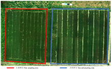
图1
试验区概况图"

表1
多光谱植被指数"
| 植被指数 Vegetation index | 计算公式 Calculation formula | 参考文献References |
|---|---|---|
| 绿度归一化植被指数GNDVI | GNDVI=(RNIR-RGreen)/(RNIR+RGreen) | [ |
| 氮反应指数NRI | NRI=(RGreen-RRed)/(RGreen+RRed) | [ |
| 花青素反射指数ARI | ARI=(1/RGreen)-(1/RRed) | [ |
| 叶斑病指数 CLSI | CLSI=(RRe-RGreen)/(RRe+RGreen)-RRe | [ |
| 植物色素比例PPR | PPR=(RGreen-RBlue)/(RGreen+RBlue) | [ |
| 绿度指数GI | GI=RGreen/RRed | [ |
| 优化土壤调节植被指数TCARI | TCARI=3×[(RNIR-RRed)-0.2×(RNIR-RGreen)×RNIR/RRed] | [ |
| 可见光大气阻抗指数VARI | VARI=(RGreen-RRed)/(RGreen+RRed-RBlue) | [ |
| 植被衰减指数PSRI | PSRI=(RRed-RGreen)/RNIR | [ |
表2
多光谱参数与DI间相关系数"
| 光谱参数 Spectral parameter | 相关系数 Correlation coefficient (r) | 光谱参数 Spectral parameter | 相关系数 Correlation coefficient (r) |
|---|---|---|---|
| R450 | 0.352** | ARI | 0.580** |
| R550 | 0.489** | CLSI | 0.586** |
| R685 | 0.413** | PPR | -0.578** |
| R725 | 0.286* | GI | -0.614** |
| R780 | -0.321** | TCARI | -0.568** |
| GNDVI | 0.504** | VARI | -0.552** |
| NRI | -0.602** | PSRI | 0.640** |

图2
不同病情下的光谱反射率变化"
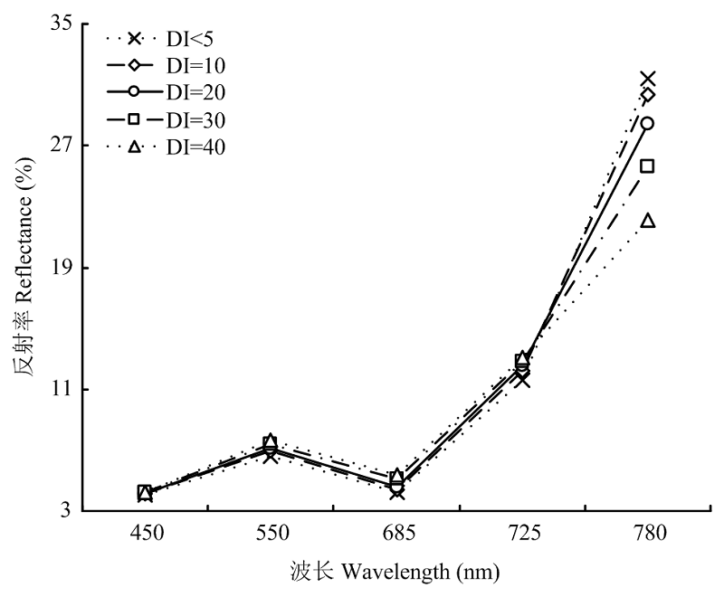
表3
多光谱纹理特征(TFs)与DI间相关系数"
| 纹理特征Texture feature | Blue | Green | Red | REDedge | NIR |
|---|---|---|---|---|---|
| 方差 Variance (Var) | 0.381** | 0.277* | 0.186 | 0.294** | 0.267* |
| 对比度Contrast ratio (Con) | 0.289* | 0.281* | 0.227* | 0.370** | 0.273* |
| 差异性Difference (Dis) | 0.328** | 0.274* | 0.242* | 0.353** | 0.260* |
| 熵 Entropy (Ent) | 0.387** | 0.240* | 0.208 | 0.277* | 0.219 |

图3
热红外温度特征与白粉病严重度间相关系数 **达到0.01显著性水平。CT为冠层温度,CTD为冠气温差,NRCT为归一化冠层温度"
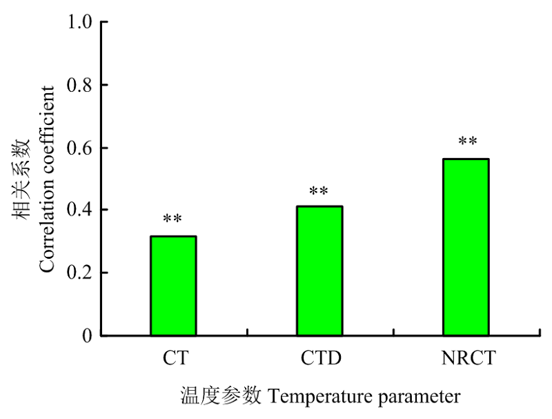
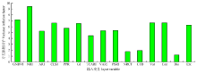
图4
任一变量与其余变量间VIF分析 GNDVI为绿度归一化指数,NRI为氮反应指数,ARI为花青素反射指数,CLSI为叶斑病指数,PPR为植物色素比例,GI为绿度指数,TCARI为优化土壤调节植被指数,VARI为可见光大气阻抗指数,PSRI为植被衰减指数,NRCT为归一化冠层温度,CTD为冠气温差,Var为方差,Con为对比度,Dis为差异性,Ent为熵"
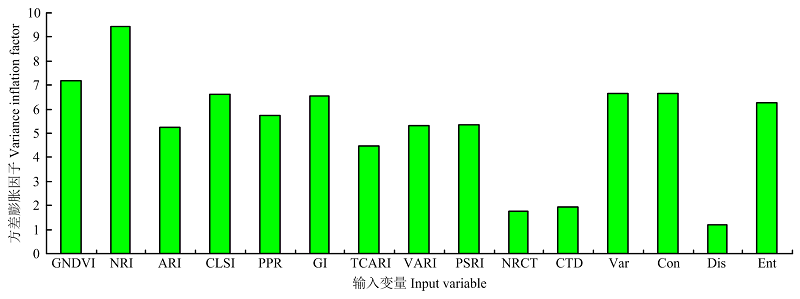
表4
基于不同算法的单数据源模型表现"
| 自变量类型 Independent variable type | 变量个数 Number of variables | 模型算法 Model algorithm | 训练集 Training set | 验证集Validation set | ||||
|---|---|---|---|---|---|---|---|---|
| R2 | RMSE | RPD | R2 | RMSE | RPD | |||
| 植被指数VIs | 9 | MLR | 0.509 | 5.796 | 1.437 | 0.528 | 8.594 | 0.957 |
| BP | 0.613 | 5.780 | 1.450 | 0.596 | 6.917 | 1.353 | ||
| ELM | 0.637 | 5.581 | 1.517 | 0.624 | 6.663 | 1.413 | ||
| RF | 0.672 | 5.398 | 1.580 | 0.661 | 6.025 | 1.563 | ||
| 纹理特征TFs | 4 | MLR | 0.247 | 7.651 | 1.210 | 0.216 | 10.515 | 0.703 |
| BP | 0.279 | 8.004 | 1.064 | 0.289 | 9.241 | 0.864 | ||
| ELM | 0.466 | 6.461 | 1.354 | 0.420 | 9.698 | 0.796 | ||
| RF | 0.499 | 7.534 | 1.242 | 0.491 | 6.493 | 1.453 | ||
| 温度特征T | 2 | MLR | 0.351 | 7.550 | 1.249 | 0.416 | 9.114 | 0.834 |
| BP | 0.431 | 6.944 | 1.322 | 0.404 | 8.154 | 1.061 | ||
| ELM | 0.540 | 6.065 | 1.368 | 0.495 | 8.495 | 0.980 | ||
| RF | 0.556 | 6.988 | 1.324 | 0.561 | 6.138 | 1.536 | ||
表5
基于不同算法的多数据源模型表现"
| 自变量 Independent variable type | 变量个数 Number of variables | 模型算法 Model algorithm | 训练集Training set | 验证集Validation set | ||||
|---|---|---|---|---|---|---|---|---|
| R2 | RMSE | RPD | R2 | RMSE | RPD | |||
| 温度特征结合纹理特征T&TFs | 6 | MLR | 0.504 | 7.527 | 1.251 | 0.501 | 7.492 | 1.217 |
| BP | 0.563 | 6.205 | 1.407 | 0.601 | 6.384 | 1.478 | ||
| ELM | 0.620 | 5.821 | 1.489 | 0.613 | 7.124 | 1.304 | ||
| RF | 0.667 | 6.180 | 1.474 | 0.647 | 6.565 | 1.436 | ||
| 植被指数结合纹理特征VIs&TFs | 13 | MLR | 0.555 | 6.600 | 1.516 | 0.541 | 6.861 | 1.366 |
| BP | 0.587 | 5.274 | 1.725 | 0.607 | 6.187 | 1.525 | ||
| ELM | 0.649 | 5.381 | 1.717 | 0.652 | 5.830 | 1.609 | ||
| RF | 0.725 | 5.242 | 1.730 | 0.676 | 5.373 | 1.717 | ||
| 植被指数结合温度特征VIs&T | 11 | MLR | 0.618 | 6.120 | 1.645 | 0.613 | 5.367 | 1.718 |
| BP | 0.627 | 6.110 | 1.646 | 0.705 | 5.907 | 1.591 | ||
| ELM | 0.695 | 5.924 | 1.736 | 0.744 | 6.190 | 1.574 | ||
| RF | 0.741 | 4.686 | 1.953 | 0.758 | 4.722 | 1.871 | ||
| 植被指数结合温度和纹理特征VIs&T&TFs | 15 | MLR | 0.603 | 6.499 | 1.694 | 0.638 | 4.932 | 1.821 |
| BP | 0.667 | 5.404 | 1.896 | 0.718 | 5.820 | 1.796 | ||
| ELM | 0.753 | 4.754 | 1.972 | 0.786 | 5.445 | 1.812 | ||
| RF | 0.806 | 4.853 | 1.968 | 0.836 | 4.501 | 2.023 | ||
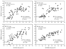
图5
3种数据源融合的模型比较"

表6
基于3种数据源融合的不同模型交叉验证"
| 模型算法 Model algorithm | 训练集Training set | 验证集Validation set | |||||
|---|---|---|---|---|---|---|---|
| R2 | RMSE | RPD | R2 | RMSE | RPD | ||
| 多元线性回归MLR | 最优模型Optimal model | 0.739 | 4.956 | 1.607 | 0.705 | 4.753 | 1.832 |
| 均值Mean | 0.637 | 5.733 | 1.567 | 0.616 | 5.947 | 1.548 | |
| 方差Variance | 0.044 | 0.391 | 0.105 | 0.081 | 1.348 | 0.319 | |
| 极差Range | 0.167 | 1.189 | 0.387 | 0.238 | 4.215 | 1.145 | |
| 反向传播神经网络BP | 最优模型Optimal model | 0.757 | 5.417 | 1.874 | 0.765 | 5.405 | 2.081 |
| 均值Mean | 0.706 | 5.411 | 1.628 | 0.725 | 5.226 | 1.626 | |
| 方差Variance | 0.036 | 0.265 | 0.129 | 0.031 | 1.391 | 0.319 | |
| 极差Range | 0.097 | 0.760 | 0.509 | 0.094 | 4.391 | 1.030 | |
| 极限学习机ELM | 最优模型Optimal model | 0.767 | 4.657 | 1.819 | 0.803 | 4.780 | 2.206 |
| 均值Mean | 0.745 | 4.796 | 1.738 | 0.785 | 5.195 | 1.720 | |
| 方差Variance | 0.020 | 0.195 | 0.088 | 0.046 | 1.384 | 0.377 | |
| 极差Range | 0.062 | 0.622 | 0.268 | 0.160 | 4.217 | 1.001 | |
| 随机森林RF | 最优模型Optimal model | 0.847 | 4.026 | 1.937 | 0.852 | 2.638 | 2.505 |
| 均值Mean | 0.841 | 4.055 | 1.813 | 0.863 | 4.183 | 1.843 | |
| 方差Variance | 0.013 | 0.122 | 0.077 | 0.028 | 0.805 | 0.315 | |
| 极差Range | 0.039 | 0.354 | 0.230 | 0.094 | 3.012 | 1.063 | |
| [1] | 张凝, 杨贵军, 赵春江, 张竞成, 杨小冬, 潘瑜春, 黄文江, 徐波, 李明, 朱西存, 李振海. 作物病虫害高光谱遥感进展与展望. 遥感学报, 2021, 25(1):403-422. |
| ZHANG N, YANG G J, ZHAO C J, ZHANG J C, YANG X D, PAN Y C, HUANG W J, XU B, LI M, ZHU X C, LI Z H. Progress and prospects of hyperspectral remote sensing technology for crop diseases and pests. National Remote Sensing Bulletin, 2021, 25(1):403-422. (in Chinese) | |
| [2] | 黄文江, 师越, 董莹莹, 叶回春, 邬明权, 崔贝, 刘林毅. 作物病虫害遥感监测研究进展与展望. 智慧农业, 2019, 1(4):1-11. |
| HUANG W J, SHI Y, DONG Y Y, YE H C, WU M Q, CUI B, LIU L Y. Progress and prospects of crop diseases and pests monitoring by remote sensing. Smart Agriculture, 2019, 1(4):1-11. (in Chinese) | |
| [3] |
SHI Y, HUANG W J, GONZALEZ-MORENO P, LUKE B, DONG Y Y, ZHENG Q, MA H Q, LIU L Y. Wavelet-based rust spectral feature set (WRSFs): A novel spectral feature set based on continuous wavelet transformation for tracking progressive host- pathogen interaction of yellow rust on wheat. Remote Sensing, 2018, 10(4):525.
doi: 10.3390/rs10040525 |
| [4] |
CHEN T T, ZHANG J L, CHEN Y, WAN S B, ZHANG L. Detection of peanut leaf spots disease using canopy hyperspectral reflectance. Computers and Electronics in Agriculture, 2019, 156:677-683.
doi: 10.1016/j.compag.2018.12.036 |
| [5] |
FRANCESCHINI M H D, BARTHOLOMEUS H, APELDOORN D F, SUOMALAINEN J, KOOISTRA L. Feasibility of Unmanned Aerial Vehicle optical imagery for early detection and severity assessment of late blight in potato. Remote Sensing, 2019, 11(3):224.
doi: 10.3390/rs11030224 |
| [6] |
MAHLEIN AK, RUMPF T, WELKE P, DEHNE HW, PLUMER L, STEINER U, OERKE E C. Development of spectral indices for detecting and identifying plant diseases. Remote Sensing of Environment, 2013, 128:21-30.
doi: 10.1016/j.rse.2012.09.019 |
| [7] |
FENG W, SHEN W Y, HE L, DUAN J Z, GUO B B, LI Y X, WANG C Y, GUO T C. Improved remote sensing detection of wheat powdery mildew using dual-green vegetation indices. Precision Agriculture, 2016, 17(5):608-627.
doi: 10.1007/s11119-016-9440-2 |
| [8] |
NAIDU R A, PERRY E M, PIERCE F J, MEKURIA T. The potential of spectral reflectance technique for the detection of Grapevine leafroll-associated virus-3 in two red-berried wine grape cultivars. Computers and Electronics in Agriculture, 2009, 66(1):38-45.
doi: 10.1016/j.compag.2008.11.007 |
| [9] | 王利民, 刘佳, 杨福刚, 杨玲波, 姚保民, 高建孟. 基于GF-1/WFV数据的冬小麦条锈病遥感监测. 农业工程学报, 2017, 33(20):153-160. |
| WANG L M, LIU J, YANG F G, YANG L B, YAO B M, GAO J M. Winter wheat stripe rust remote sensing monitoring based on GF-1/WFV data. Transactions of the Chinese Society of Agricultural Engineering, 2017, 33(20):153-160. (in Chinese) | |
| [10] | 白雪冰, 余建树, 傅泽田, 张领先, 李鑫星. 可见光谱图像联合区间的黄瓜白粉病分割与检测. 光谱学与光谱分析, 2019, 39(11):3592-3598. |
| BAI X B, YU J S, FU Z T, ZHANG L X, LI X X. Segmentation and detection of cucumber powdery mildew based on visible spectrum and image processing. Spectroscopy and Spectral Analysis, 2019, 39(11):3592-3598. (in Chinese) | |
| [11] | ASHOURLOO D, AGHIGHI H, MATKAN A A, MOBASHERI M R, RAD A M. An investigation into machine learning regression techniques for the leaf rust disease detection using hyperspectral measurement. IEEE Journal of Selected Topics in Applied Earth Observations and Remote Sensing, 2016, 9:1-8. |
| [12] | 沈文颖, 李映雪, 冯伟, 张海艳, 张元帅, 谢迎新, 郭天财. 基于因子分析-BP神经网络的小麦叶片白粉病反演模型. 农业工程学报, 2015, 31(22):183-190. |
| SHEN W Y, LI Y X, FENG W, ZHANG H Y, ZHANG Y S, XIE Y X, GUO T C. Inversion model for severity of powdery mildew in wheat leaves based on factor analysis-BP neural network. Transactions of the Chinese Society of Agricultural Engineering, 2015, 31(22):183-190. (in Chinese) | |
| [13] | 郭伟, 朱耀辉, 王慧芳, 张娟, 董萍, 乔红波. 基于无人机高光谱影像的冬小麦全蚀病监测模型研究. 农业机械学报, 2019, 50(9):162-169. |
| GUO W, ZHU Y H, WANG H F, ZHANG J, DONG P, QIAO H B. Monitoring model of winter wheat take-all based on UAV hyperspectral imaging. Transactions of the Chinese Society for Agricultural Machinery, 2019, 50(9):162-169. (in Chinese) | |
| [14] | 简俊凡, 何宏昌, 王晓飞, 李月. 农作物病虫害遥感监测综述. 测绘通报, 2018(9):24-28. |
| JIAN J F, HE H C, WANG X F, LI Y. Review of remote sensing monitoring of crop pests and diseases. Bulletin of Surveying and Mapping, 2018(9):24-28. (in Chinese) | |
| [15] | 刘畅, 杨贵军, 李振海, 汤伏全, 王建雯, 张春兰, 张丽妍. 融合无人机光谱信息与纹理信息的冬小麦生物量估测. 中国农业科学, 2018, 51(16):3060-3073. |
| LIU C, YANG G J, LI Z H, TANG F Q, WANG J W, ZHANG C L, ZHANG L Y. Biomass estimation in winter wheat by UAV spectral information and texture information fusion. Scientia Agricultura Sinica, 2018, 51(16):3060-3073. (in Chinese) | |
| [16] | 梁栋, 刘娜, 张东彦, 赵晋陵, 林芬芳, 黄林生, 张庆, 丁玉婉. 利用成像高光谱区分冬小麦白粉病与条锈病(英文). 红外与激光工程, 2017, 46(1):50-58. |
| LIANG D, LIU N, ZHANG D Y, ZHAO J L, LIN F F, HUANG L S, ZHANG Q, DING Y W. Discrimination of powdery mildew and yellow rust of winter wheat using high resolution hyper-spectra and imageries. Infrared and Laser Engineering, 2017, 46(1):50-58. (in Chinese) | |
| [17] | 张东彦, 张竞成, 朱大洲, 王纪华, 罗菊花, 赵晋陵, 黄文江. 小麦叶片胁迫状态下的高光谱图像特征分析研究. 光谱学与光谱分析, 2011, 31(4):1101-1105. |
| ZHANG D Y, ZHANG J C, ZHU D Z, WANG J H, LUO J H, ZHAO J L, HUANG W J. Investigation of the hyperspectral image characteristics of wheat leaves under different stress. Spectroscopy and Spectral Analysis, 2011, 31(4):1101-1105. (in Chinese) | |
| [18] |
ZHENG H B, CHENG T, ZHOU M, LI D, YAO X, TIAN Y, CAO W, ZHU Y. Improved estimation of rice aboveground biomass combining textural and spectral analysis of UAV imagery. Precision Agriculture, 2018, 20:1-19.
doi: 10.1007/s11119-018-09627-5 |
| [19] |
GUO A T, HUANG W J, DONG Y Y, YE H Q, MA H Q, LIU B, WU W B, REN Y, RUAN C, GENG Y. Wheat yellow rust detection using UAV-based hyperspectral technology. Remote Sensing, 2021, 13(1):123. (in Chinese)
doi: 10.3390/rs13010123 |
| [20] | 杨成娅, 张艳, 赵明珠, 朱应燕. 基于红外热像的农作物早期病害检测识别技术的研究进展. 激光杂志, 2020, 41(6):1-4. |
| YANG C Y, ZHANG Y, ZHAO M Z, ZHU Y Y. Research progress of infrared thermal imaging in early disease detection of crops. Laser Journal, 2020, 41(6):1-4. (in Chinese) | |
| [21] | 刘又夫, 肖德琴, 刘亚兰, 钟伯平, 周志艳. 褐飞虱诱导的水稻冠层热图像温度特征变异评估方法. 农业机械学报, 2020, 51(5):165-172. |
| LIU Y F, XIAO D Q, LIU Y L, ZHONG B P, ZHOU Z Y. Temperature eigenvalues evaluation method of rice canopy thermal image induced by brown rice planthopper. Transactions of the Chinese Society for Agricultural Machinery, 2020, 51(5):165-172. (in Chinese) | |
| [22] | 朱文静, 陈华, 李林, 魏新华, 毛罕平, SPANER D. 基于红外热成像边缘检测算法的小麦叶锈病分级研究. 农业机械学报, 2019, 50(4):36-41, 48. |
| ZHU W J, CHEN H, LI L, WEI X H, MAO H P, SPANER D. Grading of wheat leaf rust based on edge detection of infrared thermal imaging. Transactions of the Chinese Society for Agricultural Machinery, 2019, 50(4):36-41, 48. (in Chinese) | |
| [23] |
MAIMAITIJIANG M, SAGAN V, SIDIKE P, HARTING S, FRITSCHI F B. Soybean yield prediction from UAV using multimodal data fusion and deep learning. Remote Sensing of Environment, 2019, 237:111599.
doi: 10.1016/j.rse.2019.111599 |
| [24] | 赵叶, 竞霞, 黄文江, 董莹莹, 李存军. 日光诱导叶绿素荧光与反射率光谱数据监测小麦条锈病严重度的对比分析. 光谱学与光谱分析, 2019, 39(9):2739-2745. |
| ZHAO Y, JING X, HUANG W J, DONG Y Y, LI C J. Comparison of sun-induced chlorophyll fluorescence and reflectance data on estimating severity of wheat stripe rust. Spectroscopy and Spectral Analysis, 2019, 39(9):2739-2745. (in Chinese) | |
| [25] | 陈思媛, 竞霞, 董莹莹, 刘良云. 基于日光诱导叶绿素荧光与反射率光谱的小麦条锈病探测研究. 遥感技术与应用, 2019, 34(3):511-520. |
| CHEN S Y, JING X, DONG Y Y, LIU L Y. Detection of wheat stripe rust using solar-induced chlorophyll fluorescence and reflectance spectral indices. Remote Sensing Technology and Application, 2019, 34(3):511-520. (in Chinese) | |
| [26] | 刘林毅, 黄文江, 董莹莹, 杜小平, 马慧琴. 基于概率模型的冬小麦白粉病监测研究. 中国农业信息, 2018, 30(1):79-92. |
| LIU L Y, HUANG W J, DONG Y Y, DU X P, MA H Q. Wheat powdery mildew monitoring using probabilistic model. China Agricultural Informatics, 2018, 30(1):79-92. (in Chinese) | |
| [27] |
GITELSON A A, KAUFMAN Y J, MERZLYAK M N. Use of a green channel in remote sensing of global vegetation from EOS-MODIS. Remote Sensing of Environment, 1996, 58(3):289-298.
doi: 10.1016/S0034-4257(96)00072-7 |
| [28] |
FILELLA I, SERRANO L, SERRA J, PENUELAS J. Evaluating wheat nitrogen status with canopy reflectance indices and discriminant analysis. Crop Science, 1995, 35(5):1400-1405.
doi: 10.2135/cropsci1995.0011183X003500050023x |
| [29] |
GITELSON A A, MERZLYAK M N, CHIVKUNOVA O B. Optical properties and nondestructive estimation of anthocyanin content in plant leaves. Photochemistry and Photobiology, 2001, 74(1):38-45.
doi: 10.1562/0031-8655(2001)074<0038:OPANEO>2.0.CO;2 |
| [30] |
WANG Z J, WANG J H, LIU L Y, HUANG W J, ZHAO C J, WANG C Z. Prediction of grain protein content in winter wheat (Triticum aestivum L.) using plant pigment ratio (PPR). Field Crops Research, 2004, 90(2) : 311-321.
doi: 10.1016/j.fcr.2004.04.004 |
| [31] |
ZARCO-TEJADA P J, BERJÓN A, LÓPEZ-LOZANO R, MILLER J R, MARTÍN P, CACHORRO V, GONZÁLEZ M R, FRUTOS A D. Assessing vineyard condition with hyperspectral indices: Leaf and canopy reflectance simulation in a row-structured discontinuous canopy. Remote Sensing of Environment, 2005, 99(3):271-287.
doi: 10.1016/j.rse.2005.09.002 |
| [32] |
HABOUDANE D, MILLER J R, TREMBLAY N, ZARCO-TEJADA P J, DEXTRAZE L. Integrated narrow-band vegetation indices for prediction of crop chlorophyll content for application to precision agriculture. Remote Sensing of Environment, 2002, 81(2):416-426.
doi: 10.1016/S0034-4257(02)00018-4 |
| [33] |
NAIDU R A, PERRY E M, PIERCE F J, MEKURIA T. The potential of spectral reflectance technique for the detection of Grapevine leafroll-associated virus-3 in two red-berried wine grape cultivars. Computers and Electronics in Agriculture, 2009, 66(1):38-45.
doi: 10.1016/j.compag.2008.11.007 |
| [34] |
MERZLYAK M N, GITELSON A A, CHIVKUNOVA O B, RAKITIN V Y. Non-destructive optical detection of pigment changes during leaf senescence and fruit ripening. Physiologia Plantarum, 1999, 106(1):135-141.
doi: 10.1034/j.1399-3054.1999.106119.x |
| [35] | HARALICK R M, SHANMUGAM K, DINSTEIN I. Textural features for image classification. Studies in Media and Communication, 1973, 3(6):610-621. |
| [36] | VANI K, POONGODI S, HARIKRISHNA B. K-Means cluster based leaf disease identification in cotton plants. Indian Journal of Public Health Research and Development, 2018, 9(10):1117. |
| [37] |
LI S Y, YUAN F, ATA-UI-KARIM S T, ZHENG H B, CAO Q. Combining color indices and textures of UAV-based digital imagery for rice LAI estimation. Remote Sensing, 2019, 11(15):1763.
doi: 10.3390/rs11151763 |
| [38] |
XU J X, MA J, TANG Y N, WU W X. Estimation of sugarcane yield using a machine learning approach based on UAV-LiDAR data. Remote Sensing, 2020, 12(17):2823.
doi: 10.3390/rs12172823 |
| [39] |
FU Z P, JIANG J, GAO Y, KRIENKE B. Wheat growth monitoring and yield estimation based on multi-rotor unmanned aerial vehicle. Remote Sensing, 2020, 12(3):508.
doi: 10.3390/rs12030508 |
| [40] |
HUANG G B, ZHU Q Y, SIEW C K. Extreme learning machine: Theory and applications. Neurocomputing, 2006, 70(1/3):489-501.
doi: 10.1016/j.neucom.2005.12.126 |
| [41] | 孙立影, 杨晨, 赵海士, 常志勇. 基于极限学习机的遥感地球化学反演模型. 吉林大学学报(地球科学版), 2020, 50(6):1929-1938. |
| SUN L Y, YANG C, ZHAO H S, CHANG Z Y. Remote sensing geochemical inversion model by using extreme learning machine. Journal of Jilin University (Earth Science Edition), 2020, 50(6):1929-1938. (in Chinese) | |
| [42] | 王鑫梅, 张劲松, 孟平, 杨洪国, 孙圣. 基于无人机遥感影像的核桃冠层氮素含量估算. 农业机械学报, 2021, 52(2):178-187. |
| WANG X M, ZHANG J S, MENG P, YANG H G, SUN S. Estimation of nitrogen content in walnut canopy based on UAV remote sensing image. Transactions of the Chinese Society for Agricultural Machinery, 2021, 52(2):178-187. (in Chinese) | |
| [43] |
BREIMAN L. Random forest. Machine Learning, 2001, 45:5-32.
doi: 10.1023/A:1010933404324 |
| [44] | 刘冀, 张特, 魏榕, 张茜, 刘艳丽, 董晓华. 基于随机森林偏差校正的农业干旱遥感监测模型研究. 农业机械学报, 2020, 51(7):170-177. |
| LIU J, ZHANG T, WEI R, ZHANG Q, LIU Y L, DONG X H. Development of agricultural drought monitoring model using remote sensing based on bias-correcting random forest. Transactions of the Chinese Society for Agricultural Machinery, 2020, 51(7):170-177. (in Chinese) | |
| [45] | 冯伟, 王晓宇, 宋晓, 贺利, 王永华, 郭天财. 基于冠层反射光谱的小麦白粉病严重度估测. 作物学报, 2013, 39(8):1469-1477. |
| FENG W, WANG X Y, SONG X, HE L, WANG Y H, GUO T C. Estimation of severity level of wheat powdery mildew based on canopy spectral reflectance. Acta Agronomica Sinica, 2013, 39(8):1469-1477. (in Chinese) | |
| [46] | 沈文颖, 冯伟, 李晓, 王晓宇, 贺利, 郭天财, 李映雪. 基于叶片高光谱特征的小麦白粉病严重度估算模式. 麦类作物学报, 2015, 35(1):129-137. |
| SHEN W Y, FENG W, LI X, WANG X Y, HE L, GUO T C, LI Y X. Estimation model of wheat powdery mildew severity based on leaves hyperspectral characteristics. Journal of Triticeae Crops, 2015, 35(1):129-137. (in Chinese) | |
| [47] | GRAEFF S, LINK J, CLAUPEIN W. Identification of powdery mildew (Erysiphe graminis sp. tritici) and take-all disease (Gaeumannomyces graminis sp. tritici) in wheat (Triticum aestivum L.) by means of leaf reflectance measurements. Central European Journal of Biology, 2006, 1(2):275-288. |
| [48] |
PEÑUELAS J, FILELLA I. Visible and near-infrared reflectance techniques for diagnosing plant physiological status. Trends in Plant Science, 1998, 3(4):151-156.
doi: 10.1016/S1360-1385(98)01213-8 |
| [49] |
MAIRE G L, FRANÇOIS C, DUFRÊNE E. Towards universal broad leaf chlorophyll indices using PROSPECT simulated database and hyperspectral reflectance measurements. Remote Sensing of Environment, 2004, 89(1):1-28.
doi: 10.1016/j.rse.2003.09.004 |
| [50] |
白宗璠, 竞霞, 张腾, 董莹莹. MDBPSO算法优化的全波段光谱数据协同冠层SIF监测小麦条锈病. 作物学报, 2020, 46(8):1248-1257.
doi: 10.3724/SP.J.1006.2020.01004 |
|
BAI Z F, JING X, ZHANG T, DONG Y Y. Canopy SIF synergize with total spectral reflectance optimized by the MDBPSO algorithm to monitor wheat stripe rust. Acta Agronomica Sinica, 2020, 46(8):1248-1257. (in Chinese)
doi: 10.3724/SP.J.1006.2020.01004 |
|
| [51] | 李鑫星, 朱晨光, 白雪冰, 毛富焕, 傅泽田, 张领先. 基于可见光谱和支持向量机的黄瓜叶部病害识别方法研究. 光谱学与光谱分析, 2019, 39(7):2250-2256. |
| LI X X, ZHU C G, BAI X B, MAO F H, BO Z T, ZHANG L X. Recognition method of leaves based on visual spectrum and support vector machine. Spectroscopy and Spectral Analysis, 2019, 39(7):2250-2256. (in Chinese) | |
| [52] |
GUO A T, HUANG W J, YE H C, DONG Y Y, MA H Q, REN Y, RUAN C. Identification of wheat yellow rust using spectral and texture features of hyperspectral images. Remote Sensing, 2020, 12(9):1419.
doi: 10.3390/rs12091419 |
| [53] | CAO W X, QIAO Z Y, GAO Z Y, LU S H, TIAN F. Use of unmanned aerial vehicle imagery and a hybrid algorithm combining a watershed algorithm and adaptive threshold segmentation to extract wheat lodging. Physics and Chemistry of the Earth, 2021(6):103016. |
| [54] |
CHANDEL A K, KHOT L R, YU L X. Alfalfa (Medicago sativa L.) crop vigor and yield characterization using high-resolution aerial multispectral and thermal infrared imaging technique. Computers and Electronics in Agriculture, 2021, 182(2):105999.
doi: 10.1016/j.compag.2021.105999 |
| [55] |
FRANCESCONI S, HARFOUCHE A, MAESANO M, BALESTRA G M. UAV-based thermal, RGB imaging and gene expression analysis allowed detection of fusarium head blight and gave new insights into the physiological responses to the disease in durum wheat. Frontiers in Plant Science, 2021, 12:628575.
doi: 10.3389/fpls.2021.628575 |
| [56] | 马慧琴, 黄文江, 景元书. 遥感与气象数据结合预测小麦灌浆期白粉病. 农业工程学报, 2016, 32(9):165-172. |
| MA H Q, HUANG W J, JING Y S. Wheat powdery mildew forecasting in filling stage based on remote sensing and meteorological data. Transactions of the Chinese Society of Agricultural Engineering, 2016, 32(9):165-172. (in Chinese) | |
| [57] | 张帅堂, 王紫烟, 邹修国, 钱燕, 余磊. 基于高光谱图像和遗传优化神经网络的茶叶病斑识别. 农业工程学报, 2017, 33(22):200-207. |
| ZHANG S T, WANG Z Y, ZOU X G, QIAN Y, YU L. Recognition of tea disease spot based on hyperspectral image and genetic optimization neural network. Transactions of the Chinese Society of Agricultural Engineering, 2017, 33(22):200-207. (in Chinese) | |
| [58] |
ZHENG Q, HUANG W J, CUI X M, SHI Y, LIU L Y. New spectral index for detecting wheat yellow rust using sentinel-2 multispectral imagery. Sensors, 2018, 18(3):868.
doi: 10.3390/s18030868 |
| [59] | 张春兰, 杨贵军, 李贺丽, 汤伏全, 刘畅, 张丽妍. 基于随机森林算法的冬小麦叶面积指数遥感反演研究. 中国农业科学, 2018, 51(5):855-867. |
| ZHANG C L, YANG G J, LI H L, TANG F Q, LIU C, ZHANG L Y. Remote sensing inversion of leaf area index of winter wheat based on random forest algorithm. Scientia Agricultura Sinica, 2018, 51(5):855-867. (in Chinese) | |
| [60] | 岳继博, 杨贵军, 冯海宽. 基于随机森林算法的冬小麦生物量遥感估算模型对比. 农业工程学报, 2016, 32(18):175-182. |
| YUE J B, YANG G J, FENG H K. Comparative of remote sensing estimation models of winter wheat biomass based on random forest algorithm. Transactions of the Chinese Society of Agricultural Engineering, 2016, 32(18):175-182. (in Chinese) | |
| [61] | 竞霞, 白宗璠, 高媛, 刘良云. 利用随机森林法协同SIF和反射率光谱监测小麦条锈病. 农业工程学报, 2019, 35(13):154-161. |
| JING X, BAI Z F, GAO Y, LIU L Y. Wheat stripe rust monitoring by random forest algorithm combined with SIF and reflectance spectrum. Transactions of the Chinese Society of Agricultural Engineering, 2019, 35(13):154-161. (in Chinese) | |
| [62] | 赵晋陵, 金玉, 叶回春, 黄文江, 董莹莹, 范玲玲, 马慧琴, 江静. 基于无人机多光谱影像的槟榔黄化病遥感监测. 农业工程学报, 2020, 36(8):54-61. |
| ZHAO J L, JIN Y, YE H C, HUANG W J, DONG Y Y, FAN L L, MA H Q, JIANG J. Remote sensing monitoring of areca yellow leaf disease based on UAV multi-spectral images. Transactions of the Chinese Society of Agricultural Engineering, 2020, 36(8):54-61. (in Chinese) |
| [1] | 蔡苇荻,张羽,刘海燕,郑恒彪,程涛,田永超,朱艳,曹卫星,姚霞. 基于成像高光谱的小麦冠层白粉病早期监测方法[J]. 中国农业科学, 2022, 55(6): 1110-1126. |
| [2] | 王淑婷,孔雨光,张赞,陈红艳,刘鹏. 基于星-机光谱融合的棉花叶片SPAD值反演[J]. 中国农业科学, 2022, 55(24): 4823-4839. |
| [3] | 马啸,陈鹏飞. 基于无人机多光谱影像的小麦封垄前种植行识别方法改进[J]. 中国农业科学, 2022, 55(20): 3926-3938. |
| [4] | 周萌,韩晓旭,郑恒彪,程涛,田永超,朱艳,曹卫星,姚霞. 基于参数化和非参数化法的棉花生物量高光谱遥感估算[J]. 中国农业科学, 2021, 54(20): 4299-4311. |
| [5] | 费帅鹏,禹小龙,兰铭,李雷,夏先春,何中虎,肖永贵. 基于高光谱遥感和集成学习方法的冬小麦产量估测研究[J]. 中国农业科学, 2021, 54(16): 3417-3427. |
| [6] | 李美炫,朱西存,白雪源,彭玉凤,田中宇,姜远茂. 基于无人机影像阴影去除的苹果树冠层氮素含量遥感反演[J]. 中国农业科学, 2021, 54(10): 2084-2094. |
| [7] | 史丰智,王瑞燕,李玉环,闫宏,张晓鑫. LAI无人机多光谱遥感估测及其在盐渍土改良中的应用[J]. 中国农业科学, 2020, 53(9): 1795-1805. |
| [8] | 赵静,李志铭,鲁力群,贾鹏,杨焕波,兰玉彬. 基于无人机多光谱遥感图像的玉米田间杂草识别[J]. 中国农业科学, 2020, 53(8): 1545-1555. |
| [9] | 张振华,丁建丽,王敬哲,葛翔宇,王瑾杰,田美玲,赵启东. 集成土壤-环境关系与机器学习的干旱区土壤属性数字制图[J]. 中国农业科学, 2020, 53(3): 563-573. |
| [10] | 奚雪,赵庚星,高鹏,崔昆,李涛. 基于Sentinel卫星及无人机多光谱的滨海冬小麦种植区土壤盐分反演研究——以黄三角垦利区为例[J]. 中国农业科学, 2020, 53(24): 5005-5016. |
| [11] | 石雅娇,陈鹏飞. 一种面向农业无人机影像分割的尺度参数自动确定方法[J]. 中国农业科学, 2020, 53(17): 3496-3508. |
| [12] | 刘慧芳,贺正,贾彪,刘志,李振洲,付江鹏,慕瑞瑞,康建宏. 基于机器学习的滴灌玉米光合响应特征[J]. 中国农业科学, 2019, 52(17): 2939-2950. |
| [13] | 陈鹏飞, 梁飞. 基于低空无人机影像光谱和纹理特征的棉花氮素营养诊断研究[J]. 中国农业科学, 2019, 52(13): 2220-2229. |
| [14] | 王丹阳,陈红艳,王桂峰,丛津桥,王向锋,魏学文. 无人机多光谱反演黄河口重度盐渍土盐分的研究[J]. 中国农业科学, 2019, 52(10): 1698-1709. |
| [15] | 陈鹏飞,李刚,石雅娇,徐志涛,杨粉团,曹庆军. 一款无人机高光谱传感器的验证及其在玉米叶面积指数反演中的应用[J]. 中国农业科学, 2018, 51(8): 1464-1474. |
|
||