


中国农业科学 ›› 2019, Vol. 52 ›› Issue (6): 997-1008.doi: 10.3864/j.issn.0578-1752.2019.06.004
姬旭升1,2,3,4,李旭1,5,万泽福1,2,3,4,姚霞1,2,3,4,朱艳1,2,3,程涛1,2,3,4( )
)
收稿日期:2018-09-19
接受日期:2019-01-17
出版日期:2019-03-16
发布日期:2019-03-22
通讯作者:
程涛
作者简介:姬旭升,E-mail: 2016101011@njau.edu.cn。
基金资助:
JI XuSheng1,2,3,4,LI Xu1,5,WAN ZeFu1,2,3,4,YAO Xia1,2,3,4,ZHU Yan1,2,3,CHENG Tao1,2,3,4()
Received:2018-09-19
Accepted:2019-01-17
Online:2019-03-16
Published:2019-03-22
Contact:
Tao CHENG
摘要:
【目的】 枣树和棉花是新疆地区的两大优势作物。利用高空间分辨率遥感影像对作物进行识别,更加快速、准确地获取枣树和棉花的种植面积及其分布区域,以利于相关部门政策的制定及农作物的精确管理。【方法】 本文以新疆阿拉尔市主要农作物为研究对象,运用基于像素与面向对象的遥感影像分类方法,通过比较光谱角制图(SAM)、支持向量机(SVM)、CART决策树(DTs)、随机森林(RF)这4种机器学习算法在高空间分辨率卫星影像分类中的作物识别精度,探究影像获取时期(2016-05-10、2016-09-07、2016-10-08)及面向对象的信息提取技术对作物分类精度的影响。【结果】 5月份影像(即棉花覆膜期影像)作物分类精度最高,10月份影像次之,9月份影像最差;与基于像素的作物分类方法相比,面向对象的作物分类方法可以使各时期的作物分类总体精度得到一定提高(除SAM之外),各时期分类精度分别提高了4.83%、7.77%、7.22%,最高分类精度分别为93.52%(2016-05-10)、85.36%(2016-09-07)、88.88%(2016-10-08),均实现了较好的作物分类效果。【结论】 5月份(棉花覆膜期)影像对棉花和枣树分类效果最好,该时期的棉花被地膜覆盖,且枣树表现出明显的植被光谱特性,两种作物生长早期呈现出差异化的光谱特征,因此棉花和枣树的遥感识别应在作物生长早期进行;面向对象的分类方法可以综合运用光谱、纹理及空间信息,特别是纹理信息的加入,可以取得比基于像素方法更高的分类精度,且提供一种高效提取田块边界的手段,对当地农田信息化管理具有重要应用价值。在棉花和枣树识别过程中,纹理特征的重要性高于光谱和空间特征,红光和绿光波段在所有波段中对棉花和枣树的识别贡献最大。
姬旭升,李旭,万泽福,姚霞,朱艳,程涛. 基于高空间分辨率卫星影像的新疆阿拉尔市棉花与枣树分类[J]. 中国农业科学, 2019, 52(6): 997-1008.
JI XuSheng,LI Xu,WAN ZeFu,YAO Xia,ZHU Yan,CHENG Tao. Pixel-Based and Object-Oriented Classification of Jujube and Cotton Based on High Resolution Satellite Imagery over Alear, Xinjiang[J]. Scientia Agricultura Sinica, 2019, 52(6): 997-1008.

图1
研究区位置图"
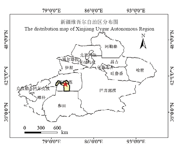
表1
获取的卫星影像"
| 卫星 Satellite | 波段类型 Band type | 空间分辨率 Spatial resolution (m) | 波段 Band | 获取时间 Date of image acquisition |
|---|---|---|---|---|
| SPOT-6 | 全色Panchromatic | 1.5 | 全色Panchromatic | 2016-05-10 |
| 多光谱Multispectral | 6 | 蓝Blue | ||
| 绿Green | ||||
| 红Red | ||||
| 近红外Near-infrared | ||||
| Pleiades-1 | 全色Panchromatic | 0.5 | 全色Panchromatic | 2016-09-17 |
| 多光谱Multispectral | 2 | 蓝Blue | ||
| 绿Green | ||||
| 红Red | ||||
| 近红外Near-infrared | ||||
| Worldview-3 | 全色Panchromatic | 0.5 | 全色Panchromatic | 2016-10-08 |
| 多光谱Multispectral | 2 | 海岸Coastal | ||
| 蓝Blue | ||||
| 绿Green | ||||
| 黄色Yellow | ||||
| 红Red | ||||
| 红边Red edge | ||||
| 近红外Near-infrared | ||||
| 近红外2 Near-infrared 2 |
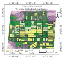
图2
采样区空间分布 底图为研究区假彩色影像,R:Red;G:NIR;B:Green,矢量数据为采样区"


图3
作物分类流程图"
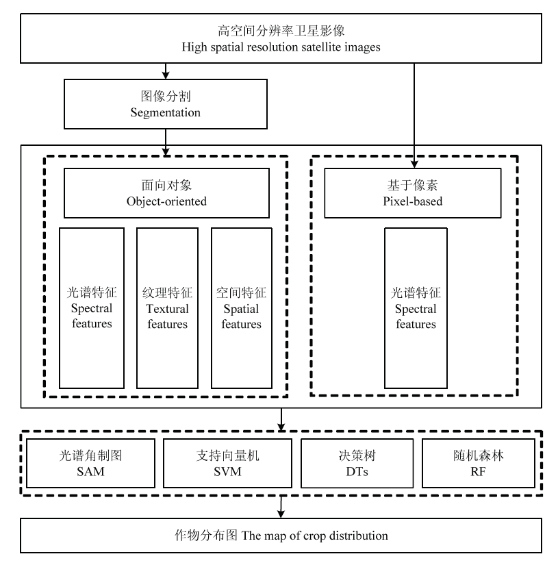
表2
不同时期作物分类总体精度"
| 获取时间 Date of image acquisition | 光谱角制图SAM | 支持向量机SVM | 决策树DTs | 随机森林RF | ||||||||||||
|---|---|---|---|---|---|---|---|---|---|---|---|---|---|---|---|---|
| 基于像素 Pixel-based | 基于对象 Object-based | 基于像素 Pixel-based | 基于对象 Object-based | 基于像素 Pixel-based | 基于对像 Object-based | 基于像素 Pixel-based | 基于对象 Object-based | |||||||||
| OA | K | OA | K | OA | K | OA | K | OA | K | OA | K | OA | K | OA | K | |
| 2016-05-10 | 87.47 | 0.81 | 64.62 | 0.47 | 78.35 | 0.67 | 90.25 | 0.85 | 90.93 | 0.86 | 92.12 | 0.88 | 91.27 | 0.87 | 93.52 | 0.90 |
| 2016-09-07 | 68.56 | 0.52 | 67.36 | 0.50 | 74.23 | 0.62 | 84.04 | 0.76 | 76.90 | 0.66 | 85.36 | 0.78 | 79.37 | 0.69 | 84.40 | 0.77 |
| 2016-10-08 | 78.30 | 0.67 | 74.21 | 0.61 | 77.53 | 0.67 | 88.88 | 0.83 | 80.13 | 0.70 | 88.77 | 0.83 | 82.14 | 0.73 | 83.82 | 0.78 |

图4
基于像素的枣树及棉花各时期用户精度及生产者精度对比"
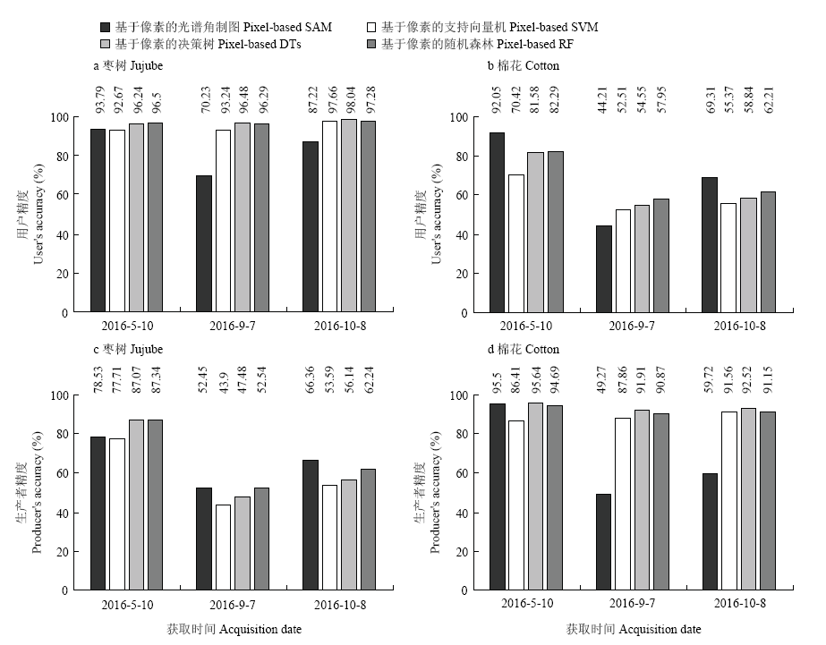
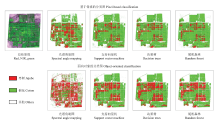
图5
基于像素与面向对象的单时期(2016-09-07)作物分布图"

表3
像素与对象水平的枣树及棉花单时期(2016-09-07)分类精度比较"
| 空间尺度 Spatial scale | 光谱角制图SAM | 支持向量机SVM | 决策树DTs | 随机森林RF | ||||||||||||
|---|---|---|---|---|---|---|---|---|---|---|---|---|---|---|---|---|
| 枣树Jujube | 棉花Cotton | 枣树Jujube | 棉花Cotton | 枣树Jujube | 棉花Cotton | 枣树Jujube | 棉花Cotton | |||||||||
| UA | PA | UA | PA | UA | PA | UA | PA | UA | PA | UA | PA | UA | PA | UA | PA | |
| 面向对象 Object-oriented | 69.17 | 50.44 | 63.81 | 54.40 | 96.17 | 60.61 | 64.47 | 96.09 | 97.65 | 67.75 | 67.12 | 92.49 | 98.29 | 62.19 | 65.76 | 92.29 |
| 基于像素 Pixel-based | 70.23 | 52.45 | 44.21 | 49.27 | 93.24 | 43.90 | 52.15 | 87.86 | 96.48 | 47.48 | 54.55 | 91.91 | 96.29 | 52.54 | 57.95 | 90.87 |

图6
研究区不同时期的假彩色合成图"
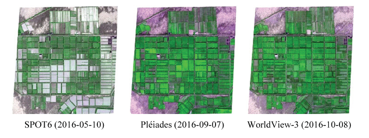

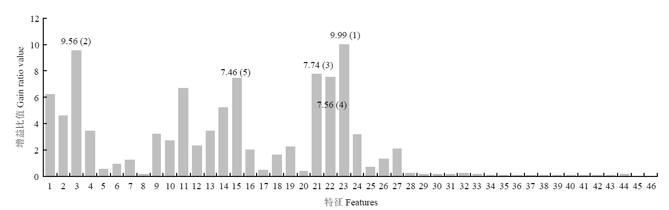
图7
基于增益比值的特征重要性 1—4:蓝、绿、红、近红外波段光谱均值 Spectral Blue, Green, Red, NIR Mean;5—8:蓝、绿、红、近红外波段光谱标准差 Spectral Blue, Green, Red, NIR Std;9—12:蓝、绿、红、近红外波段光谱最小值 Spectral Blue, Green, Red, NIR Min;13—16:蓝、绿、红、近红外波段光谱最大值 Spectral Blue, Green, Red, NIR Max;17—20:蓝、绿、红、近红外波段纹理范围 Texture Blue, Green, Red, NIR Range;21—24:蓝、绿、红、近红外波段纹理均值Texture Blue, Green, Red, NIR Mean;25—28:蓝、绿、红、近红外波段纹理方差 Texture Blue, Green, Red, NIR Variance;29—32:蓝、绿、红、近红外波段纹理信息熵 Texture Blue, Green, Red, NIR Entropy;33:对象面积 Area;34:对象外边框周长 Length;35:紧凑型 Compactness;36:凸出的状态 Convexity;37:坚固性 Solidity;38:圆特性 Roundness;39:形状要素 Form Factor;40:延伸性 Elongation;41:矩形形状的度量 Rectangular Fit;42:主方向 Main Direction;43—44:长、短轴长度 Major, Minor Length;45:洞的个数 Number of Holes;46:对象和外轮廓的面积比 Hole Area/Solid Area"
| [1] | 新疆维吾尔自治区统计局. 新疆统计年鉴. 北京: 中国统计出版社, 2016. |
| National Bureau of Statistics of the Xinjiang Uygur Autonomous Region. Xinjiang Statistical Yearbook. Beijing: China Statistics Press, 2016. (in Chinese) | |
| [2] |
张焕雪, 李子强, 文宁, 杜鑫, 陶青山, 田亦陈 . 农作物种植面积遥感估算的影响因素研究. 国土资源遥感, 2015,27(4):54-61.
doi: 10.6046/gtzyyg.2015.04.09 |
|
ZHANG H X, LI Z Q, WEN N, DU X, TAO Q S, TIAN Y C . Important factors affecting crop acreage estimation based on remote sensing image classification technique. Remote Sensing for Land and Resources, 2015,27(4):54-61. (in Chinese)
doi: 10.6046/gtzyyg.2015.04.09 |
|
| [3] |
WALDNER F, CANTO G S, DEFOUNRNY P . Automated annual cropland mapping using knowledge-based temporal features. ISPRS Journal of Photogrammetry and Remote Sensing, 2015,110:1-13.
doi: 10.1016/j.isprsjprs.2015.09.013 |
| [4] |
DALMAU O S , ALARCÓN T E, OLIVA F E . Crop classification in satellite images through probabilistic segmentation based on multiple sources. Sensors, 2017,17(6):1373.
doi: 10.3390/s17061373 pmid: 5492153 |
| [5] |
ABOUEL M L, TANTON T . Improvements in land use mapping for irrigated agriculture from satellite sensor data using a multi-stage maximum likelihood classification. Remote Sensing, 2003,24(21):4197-4206.
doi: 10.1080/0143116031000139791 |
| [6] |
ALGANCI U, SERTEL E, OZDOGAN M, ORMECI C . Parcel-level identification of crop types using different classification algorithms and multi-resolution imagery in southeastern turkey. Photogrammetric Engineering and Remote Sensing, 2013,79(11):1053-1065.
doi: 10.14358/PERS.79.11.1053 |
| [7] |
SAMANIEGO L, SCHULZ K . Supervised classification of agricultural land cover using a modified K-NN technique (mnn) and Landsat remote sensing imagery. Remote Sensing, 2009,1(4):875-895.
doi: 10.3390/rs1040875 |
| [8] | CRIST E P, CICONE R C . Application of the tasseled cap concept to simulated thematic mapper data. Photogrammetric Engineering & Remote Sensing, 1984,50(3):343-352. |
| [9] |
WARDLOW B D, EGBERT S L, KASTENS J H . Analysis of time- series MODIS 250 m vegetation index data for crop classification in the us central great plains. Remote Sensing of Environment, 2007,108(3):290-310.
doi: 10.1016/j.rse.2006.11.021 |
| [10] |
DURO D C, FRANKLIN S E, DUBÉ M G . A comparison of pixel-based and object-based image analysis with selected machine learning algorithms for the classification of agricultural landscapes using spot-5 hrg imagery. Remote Sensing of Environment, 2012,118:259-272.
doi: 10.1016/j.rse.2011.11.020 |
| [11] |
ALGANCI U, SERTEL E, OZDOGAN M, ORMECI C . Parcel-level identification of crop types using different classification algorithms and multi-resolution imagery in southeastern turkey. Photogrammetric Engineering and Remote Sensing, 2013,79(11):1053-1065.
doi: 10.14358/PERS.79.11.1053 |
| [12] |
LIU J, SHAO G, ZHU H, LIU S . A neural network approach for enhancing information extraction from multispectral image data. Canadian Journal of Remote Sensing, 2005,31(6):432-438.
doi: 10.5589/m05-027 |
| [13] |
OMKAR S, SENTHILNATH J, MUDIGERE D, KUMAR M M . Crop classification using biologically-inspired techniques with high resolution satellite image. Journal of the Indian Society of Remote Sensing, 2008,36(2):175-182.
doi: 10.1007/s12524-008-0018-y |
| [14] | MASSE A . Développement et automatisation de méthodes de classification partir de séries temporelles d’images de télédétection - application aux changements d’occupation des sols et à l’estimation du bilan carbone[D]. Toulouse: Université Toulouse III Paul Sabatier, 2013: 223. |
| [15] |
PETITJEAN F, INGLADA J , GANÇARSKI P . Satellite image time series analysis under time warping.IEEE Transactions on Geoscience and Remote Sensing, 50(8):3081-3095.
doi: 10.1109/TGRS.2011.2179050 |
| [16] |
OSMAN J, INGLADA J, DEJOUX J F . Assessment of a markov logic model of crop rotations for early crop mapping. Computers and Electronics in Agriculture, 2015,113:234-243.
doi: 10.1016/j.compag.2015.02.015 |
| [17] |
MARIANA B, OVIDIU C . Sentinel-2 cropland mapping using pixel-based and object-based time-weighted dynamic time warping analysis. Remote Sensing of Environment, 2018,204:509-523.
doi: 10.1016/j.rse.2017.10.005 |
| [18] |
刘吉凯, 钟仕全, 梁文海 . 基于多时相Landsat 8 OLI影像的作物种植结构提取. 遥感技术与应用, 2015,30(4):775-783.
doi: 10.11873/j.issn.1004-0323.2015.4.0775 |
|
LIU J K, ZHONG S Q, LIANG W H . Extraction on crops planting structure based on multi-temporal Landsat8 OLI images. Remote Sensing of Technology and Application, 2015,30(4):775-783. (in Chinese)
doi: 10.11873/j.issn.1004-0323.2015.4.0775 |
|
| [19] |
黄健熙, 侯焯, 武洪峰, 刘峻明, 朱德海 . 基于时间序列MODIS的农作物类型空间制图方法. 农业机械学报, 2017,48(10):142-148.
doi: 10.6041/j.issn.1000-1298.2017.10.017 |
|
HUANG J X, HOU Z, WU H F, LIU J M, ZHU D H . Crop type mapping method based on time-series MODIS data in Heilongjiang province. Transactions of the Chinese Society for Agricultural Machinery, 2017,48(10):142-148. (in Chinese)
doi: 10.6041/j.issn.1000-1298.2017.10.017 |
|
| [20] |
MCCARTY J L , NEIGH C S R, CARROLL M L, WOOTEN M R . Extraction smallholder cropped area in Tigray, Ethiopia, with wall-to-wall sub-meter WorldView and moderate resolution Landsat 8 imagery. Remote Sensing of Environment, 2017,202:142-151.
doi: 10.1016/j.rse.2017.06.040 |
| [21] |
WEI C W, HUANG J F, MANSARAY L, LI Z H, LIU W W, HAN J H . Estimation and mapping of winter oilseed rape LAI from high spatial resolution satellite data based on a hybrid method. Remote Sensing, 2017,9(5):488-503.
doi: 10.3390/rs9050488 |
| [22] |
刘克宝, 刘述彬, 陆忠军, 宋茜, 刘艳霞, 张冬梅, 吴文斌 . 利用高空间分辨率遥感数据的农作物种植结构提取. 中国农业资源与区划, 2014,35(1):1-5.
doi: 10.7621/cjarrp.1005-9121.20130601 |
|
LIU K B, LIU S B, LU ZJ, SONG X, LIU Y X, ZHANG D M, WU W B . Cropping structure Extraction based on high spatial resolution remotely sensed data. Chinese Journal of Agricultural Resources and Regional Planning, 2014,35(1):1-5. (in Chinese)
doi: 10.7621/cjarrp.1005-9121.20130601 |
|
| [23] |
AKBARI M, MAMANPOUSH A R, GIESKE A. MIRANZADEH M., TORABI M, SALEMI H . Crop and land cover classification in Iran using Landsat 7 imagery. International Journal of Remote Sensing, 2006,27(19):4117-4135.
doi: 10.1080/01431160600784192 |
| [24] |
POTGIETER A B, APAN A, DUNN P, HAMMER G . Estimating crop area using seasonal time series of enhanced vegetation index from modis satellite imagery. Crop Pasture Science, 2007,58(4):316-325.
doi: 10.1071/AR06279 |
| [25] |
ARVOR D, JONATHAN M , MEIRELLES M S P, DUBREUIL V, DURIEUX L . Classification of MODIS EVI time series for crop mapping in the state of mato grosso, brazil. International Journal of Remote Sensing, 2011, 32(22):7847-7871.
doi: 10.1080/01431161.2010.531783 |
| [26] |
MYINT S W, PATRICIA G, ANTHONY B, SUSANNE G C, WEN Q H .Per-pixel vs . object-based classification of urban land cover extraction using high spatial resolution imagery. Remote Sensing of Environment, 2011,115(5):1145-1161.
doi: 10.1016/j.rse.2010.12.017 |
| [27] |
BLASCHKE T, GEOFFREY J H, MAGGI K, STEFAN L, PETER H, ELISABETH A, RAUL Q F, FREEK M, HARALD W, FRIEKE C, DIRK T . Geographic object-based image analysis - towards a new paradigm. ISPRS Journal of Photogrammetry and Remote Sensing, 2014,87:180-191.
doi: 10.1016/j.isprsjprs.2013.09.014 pmid: 3945831 |
| [28] |
MA L, LI M C, MA X X. CHENG L, DU P J, LIU Y X . A review of supervised object-based land-cover image classification. ISPRS Journal of Photogrammetry and Remote Sensing, 2017,130:277-293.
doi: 10.1016/j.isprsjprs.2017.06.001 |
| [29] |
LI Q Z, CAO X, JI K, ZHANG M, DONG Q H . Crop type identification by integration of high-spatial resolution multispectral data with features extracted from coarse-resolution time-series vegetation index data. International Journal of Remote Sensing, 2014,35(16):6076-6088.
doi: 10.1080/01431161.2014.943325 |
| [30] |
BLASCHKE T . Object based image analysis for remote sensing. ISPRS Journal of Photogrammetry and Remote Sensing, 2010,65(1):2-16.
doi: 10.1016/j.isprsjprs.2009.06.004 |
| [31] | 邓书斌 . ENVI 遥感图像处理方法. 北京: 科学出版社, 2010. |
| DENG S B. ENVI Remote Sensing Image Processing Method. Beijing: Science Press, 2010. ( in Chinese) | |
| [32] |
ROERDINK J B, MEIJSTER A . The watershed transform: definitions, algorithms, and parallelization strategies. Fundamenta informaticae, 2001,41:187-228.
doi: 10.3233/FI-2000-411207 |
| [33] |
BLEAU A, LEON L J . Watershed-based segmentation and region merging. computer Vision and Image Understanding, 2000,77(3):317-370.
doi: 10.1006/cviu.1999.0822 |
| [34] |
PEÑA-BARRAGÁN J M, NGUGI M K, RICHARD E P, JOHAN S . Object-based crop identification using multiple vegetation indices, textural features and crop phenology. Remote Sensing of Environment, 2011,115(6):1301-1316.
doi: 10.1016/j.rse.2011.01.009 |
| [35] |
ZHONG C, WANG C Z, WU C S . MODIS-based fractional crop mapping in the U.S. midwest with spatially constrained phenological mixture analysis, Remote Sensing, 2015,7(1):512-529.
doi: 10.3390/rs70100512 |
| [36] |
ZHONG L, HAWKINS T, BIGING G, GONG P . A phenology-based approach to map crop types in the San Joaquin Valley, California. International Journal of Remote Sensing, 2011,32(22):7777-7804.
doi: 10.1080/01431161.2010.527397 |
| [37] |
HELMHOLZ P, ROTTENSTEINER F, HEIPKE C . Semi-automatic verification of cropland and grassland using very high resolution mono-temporal satellite images. ISPRS Journal of Photogrammetry and Remote Sensing, 2014,97:204-218.
doi: 10.1016/j.isprsjprs.2014.09.008 |
| [38] |
LÖW F, KNÖFEL P, CONRAD C . Analysis of uncertainty in multi- temporal object-based classification. ISPRS Journal of Photogrammetry and Remote Sensing, 2015,105:91-106.
doi: 10.1016/j.isprsjprs.2015.03.004 |
| [39] |
LI Q T, WANG C Z, ZHANG B, LU L L . Object-based crop classification with Landsat-MODIS enhanced time-series data. Remote Sensing, 2015,7(12):16091-16107.
doi: 10.3390/rs71215820 |
| [40] |
DURO D C, FRANKLIN S E, DUBÉ M G . A comparison of pixel-based and object-based image analysis with selected machine learning algorithms for the classification of agricultural landscapes using SPOT-5 HRG imagery. Remote Sensing of Environment, 2012,118:259-272.
doi: 10.1016/j.rse.2011.11.020 |
| [41] |
MA L, CHENG L, LI M C, LIU Y X, MA X X . Training set size, scale, and features in Geographic Object-Based Image Analysis of very high resolution unmanned aerial vehicle imagery. ISPRS Journal of Photogrammetry and Remote Sensing, 2015,102:14-27.
doi: 10.1016/j.isprsjprs.2014.12.026 |
| [42] |
LALIBERTE A S, BROWNING D M, RANGO A . A comparison of three feature selection methods for object-based classification of sub-decimeter resolution UltraCam-L imagery. International Journal of Applied Earth Observation and Geoinformation, 2012,15:70-78.
doi: 10.1016/j.jag.2011.05.011 |
| [1] | 杨改青, 王林枫, 李文清, 朱河水, 付彤, 廉红霞, 张立阳, 滕战伟, 张黎杰, 任宏, 徐新颖, 刘新鹤, 魏钰轩, 高腾云. 基于昼夜节律的牛奶品质研究[J]. 中国农业科学, 2023, 56(2): 379-390. |
| [2] | 王俊娟,陆许可,王延琴,王帅,阴祖军,付小琼,王德龙,陈修贵,郭丽雪,陈超,赵兰杰,韩迎春,孙亮庆,韩明格,张悦新,范亚朋,叶武威. 陆地棉遗传标准系TM-1的特性及其耐冷性[J]. 中国农业科学, 2022, 55(8): 1503-1517. |
| [3] | 沈倩,张思平,刘瑞华,刘绍东,陈静,葛常伟,马慧娟,赵新华,杨国正,宋美珍,庞朝友. 棉花出苗期耐冷综合评价体系的构建及耐冷指标筛选[J]. 中国农业科学, 2022, 55(22): 4342-4355. |
| [4] | 黄翀,侯相君. 基于Bi-LSTM模型的时间序列遥感作物分类研究[J]. 中国农业科学, 2022, 55(21): 4144-4157. |
| [5] | 郭灿,岳晓凤,白艺珍,张良晓,张奇,李培武. 花生黄曲霉毒素平衡取样-随机森林风险预警模型的应用研究[J]. 中国农业科学, 2022, 55(17): 3426-3436. |
| [6] | 申哲,张认连,龙怀玉,徐爱国. 基于机器学习方法的宁夏南部土壤质地空间分布研究[J]. 中国农业科学, 2022, 55(15): 2961-2972. |
| [7] | 汤明尧,沈重阳,陈署晃,唐光木,李青军,闫翠侠,耿庆龙,傅国海. 新疆小麦、玉米的产量和氮磷钾肥利用效率[J]. 中国农业科学, 2022, 55(14): 2762-2774. |
| [8] | 王宁,冯克云,南宏宇,张铜会. 不同水分条件下有机无机肥配施对棉花根系特征及产量的影响[J]. 中国农业科学, 2022, 55(11): 2187-2201. |
| [9] | 侯彤瑜,郝婷丽,王海江,张泽,吕新. 棉花生长发育模型及其在我国的研究和应用进展[J]. 中国农业科学, 2021, 54(6): 1112-1126. |
| [10] | 娄善伟,董合忠,田晓莉,田立文. 新疆棉花“矮、密、早”栽培历史、现状和展望[J]. 中国农业科学, 2021, 54(4): 720-732. |
| [11] | 李青,鱼海鹏,张子豪,孙正文,张艳,张冬梅,王省芬,马峙英,阎媛媛. 棉花真叶原生质体分离及瞬时表达体系的优化[J]. 中国农业科学, 2021, 54(21): 4514-4524. |
| [12] | 聂军军,代建龙,杜明伟,张艳军,田晓莉,李召虎,董合忠. 我国现代植棉理论与技术的新发展——棉花集中成熟栽培[J]. 中国农业科学, 2021, 54(20): 4286-4298. |
| [13] | 周萌,韩晓旭,郑恒彪,程涛,田永超,朱艳,曹卫星,姚霞. 基于参数化和非参数化法的棉花生物量高光谱遥感估算[J]. 中国农业科学, 2021, 54(20): 4299-4311. |
| [14] | 周京龙,冯自力,魏锋,赵丽红,张亚林,周燚,冯鸿杰,朱荷琴. 棉花内生细菌YUPP-10及其分泌蛋白CGTase对棉花枯萎病的防治作用及机理[J]. 中国农业科学, 2021, 54(17): 3691-3701. |
| [15] | 文明, 李明华, 蒋家乐, 马学花, 李容望, 赵文青, 崔静, 刘扬, 马富裕. 氮磷钾运筹模式对北疆滴灌棉花生长发育和产量的影响[J]. 中国农业科学, 2021, 54(16): 3473-3487. |
|
||