


中国农业科学 ›› 2019, Vol. 52 ›› Issue (10): 1698-1709.doi: 10.3864/j.issn.0578-1752.2019.10.004
王丹阳1,陈红艳1( ),王桂峰2,丛津桥3,王向锋4,魏学文2
收稿日期:2018-12-28
接受日期:2019-03-05
出版日期:2019-05-16
发布日期:2019-05-23
联系方式:
王丹阳,E-mail: 892218027@qq.com。
基金资助:
WANG DanYang1,CHEN HongYan1(),WANG GuiFeng2,CONG JinQiao3,WANG XiangFeng4,WEI XueWen2
Received:2018-12-28
Accepted:2019-03-05
Published:2019-05-16
Online:2019-05-23
摘要:
【目的】为提高土壤盐分信息定量遥感提取精度,准确掌握土壤盐渍化程度与分布。【方法】选择垦利区黄河口镇集中连片的重度盐渍土区域为试验区,于2018年4月26日—28日采用搭载Sequoia多光谱相机的无人机进行试验区近地遥感图像采集,并进行图像拼接、辐射校正、正射校正和几何校正等预处理;然后基于相关性分析、灰色关联度分析筛选土壤盐分的敏感波段,构建并筛选光谱参量;进而分别采用多元线性回归(multivariable linear regression,MLR)、支持向量机(support vector machine,SVM)及偏最小二乘(partial least square,PLS)方法构建土壤盐分定量反演模型,并进行验证与评价;最后基于最佳模型进行试验区土壤盐分的分布反演与分析,并与反距离加权插值结果进行精度比较。【结果】相较相关性分析,通过灰色关联度分析的反演模型精度及显著性均有所提高;对比3种建模方法,SVM模型精度最高,PLS模型次之,MLR模型最低,最佳模型为基于灰色关联度分析筛选变量的支持向量机模型,其建模R 2、RMSE分别为0.820、3.626,验证R 2、RMSE、RPD分别为0.773、4.960、2.200;据此模型反演得到该区域土壤盐分含量为0.323—21.210 g·kg -1,平均值为6.871 g·kg -1,重度盐渍土占58.094%,与实地调查结果较为一致;反演结果与反距离加权插值结果的误差80%控制在样本盐分含量平均值的20%以内,亦较为相近。 【结论】基于无人机多光谱可实现重度盐渍土盐分信息的准确提取。
王丹阳,陈红艳,王桂峰,丛津桥,王向锋,魏学文. 无人机多光谱反演黄河口重度盐渍土盐分的研究[J]. 中国农业科学, 2019, 52(10): 1698-1709.
WANG DanYang,CHEN HongYan,WANG GuiFeng,CONG JinQiao,WANG XiangFeng,WEI XueWen. Salinity Inversion of Severe Saline Soil in the Yellow River Estuary Based on UAV Multi-Spectra[J]. Scientia Agricultura Sinica, 2019, 52(10): 1698-1709.
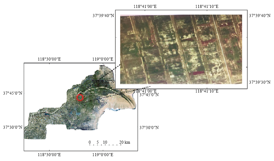
图1
黄河口镇及试验区空间位置示意图"

图2
无人机飞行航线图"
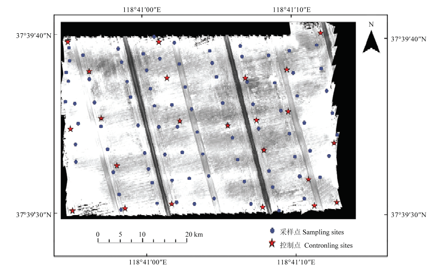
图3
试验区假彩色合成波段图像和样点分布图"
表1
敏感波段分析"
| 波段 Band | 相关系数 Correlation coefficient | 灰色关联度指数 Grey correlation index |
|---|---|---|
| 红光 (red,r) | -0.642** | -0.684** |
| 绿光 (gre,g) | -0.591** | -0.688** |
| 红边 (reg) | -0.590* | -0.665* |
| 近红 (nir) | -0.573* | -0.670* |
表2
光谱指数分析"
| 序号 Number | 光谱指数 Spcetral index | 相关系数 Correlation coefficient | 灰色关联度指数 Grey correlation index |
|---|---|---|---|
| 1 | r+nir | -0.645** | -0.720** |
| 2 | R×nir | -0.600* | -0.708** |
| 3 | r/g | -0.185 | -0.756** |
| 4 | R+nir+g | -0.641** | -0.665** |
| 5 | $\sqrt{r^{2}+reg^{2}}$ | -0.601** | -0.668** |
| 6 | g×nir | -0.562* | -0.658* |
| 7 | g+reg | -0.603* | -0.671* |
| 8 | (r+g)/(r-g) | -0.015 | -0.471* |
| 9 | g×r | -0.145 | -0.701* |
| 10 | $\sqrt{r^{2}+g^{2}}$ | -0.640** | -0.700** |
| 11 | r+nir+reg | -0.631** | -0.709** |
| 12 | r×reg | -0.591* | -0.649* |
| 13 | r+reg | -0.634** | -0.691** |
| 14 | (reg-r)/( reg+r) | 0.252 | -0.183 |
| 15 | g×nir×r | -0.556* | -0.603* |
| 16 | g+r+reg | -0.632* | -0.678* |
| 17 | g×r×reg | -0.037 | -0.576* |
| 18 | g×reg | -0.124 | -0.609* |
| 19 | (reg-g)/( reg+g) | 0.148 | -0.354 |
| 20 | r-g | -0.21 | -0.206 |
| 21 | reg-r | 0.048 | -0.079 |
| 22 | reg/r | -0.17 | -0.709* |
| 23 | $\sqrt{g^{2}+reg^{2}+r^{2}}$ | -0.601* | -0.668* |
| 24 | $\sqrt{r\times reg}$ | -0.634* | -0.689* |
| 25 | $\sqrt{r\times r}$ | -0.643* | -0.702* |
| 26 | $\sqrt{g^{2}+reg^{2}}$ | -0.605* | -0.669* |
| 27 | (reg+g)/(g-reg) | 0.117 | -0.238 |
| 28 | (r+g)/(r-g) | -0.015 | -0.471* |
| 29 | $\sqrt{reg\times g}$ | -0.631* | -0.679* |
| 30 | $\sqrt{reg \times r \times g}$ | -0.613* | -0.689* |
| 31 | r+nir+g+reg | -0.631* | -0.660* |
| 32 | r+nir+g | -0.641* | -0.665* |
| 33 | nir+g+reg | -0.606* | -0.652* |
表3
土壤盐分反演模型"
| 分析方法 Analytical methods | 建模方法 Modeling methods | 建模精度Calibration accuracy | 验证精度Verification accuracy | |||
|---|---|---|---|---|---|---|
| 决定系数 R2 | 均方根误差 RMSE | 决定系数 R2 | 均方根误差 RMSE | 相对分析误差 RPD | ||
| 相关性分析 Correlation analysis | MLR | 0.645 | 5.217 | 0.564 | 5.157 | 1.261 |
| SVM | 0.730 | 5.363 | 0.782 | 5.596 | 2.083 | |
| PLS | 0.711 | 5.545 | 0.707 | 5.362 | 1.870 | |
| 灰色关联度 Grey correlation index | MLR | 0.691 | 4.291 | 0.687 | 5.013 | 1.731 |
| SVM | 0.820 | 3.626 | 0.773 | 4.960 | 2.203 | |
| PLS | 0.722 | 4.677 | 0.724 | 4.731 | 2.210 | |
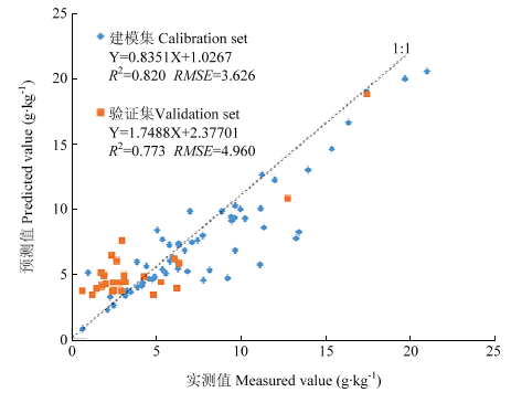
图4
最佳模型散点图"

图5
土壤盐分含量反演图"
表4
试验区土壤盐分等级及其比例"
| 等级 Grade | 反演图Inversion map | 插值图 Interpolation map | ||
|---|---|---|---|---|
| 像元数 Pixel count | 所占比例 Percentage (%) | 像元数 Pixel count | 所占比例 Percentage (%) | |
| 非盐渍土Non-saline soil (<2.0 g·kg-1) | 3027962 | 7.640 | 1025934 | 2.476 |
| 轻度盐渍土Mild saline soil (≥2.0-4.0 g·kg-1) | 1928771 | 4.871 | 7327621 | 17.691 |
| 中度盐渍土Moderate saline soil (≥4.0-6.0g·kg-1) | 10091297 | 25.473 | 11092173 | 26.779 |
| 重度盐渍土Severe saline soil (≥6.0-10.0 g·kg-1) | 23018069 | 58.094 | 20015014 | 48.321 |
| 盐土Solonchak (≥10.0 g·kg-1) | 1558977 | 3.932 | 1959849 | 4.731 |
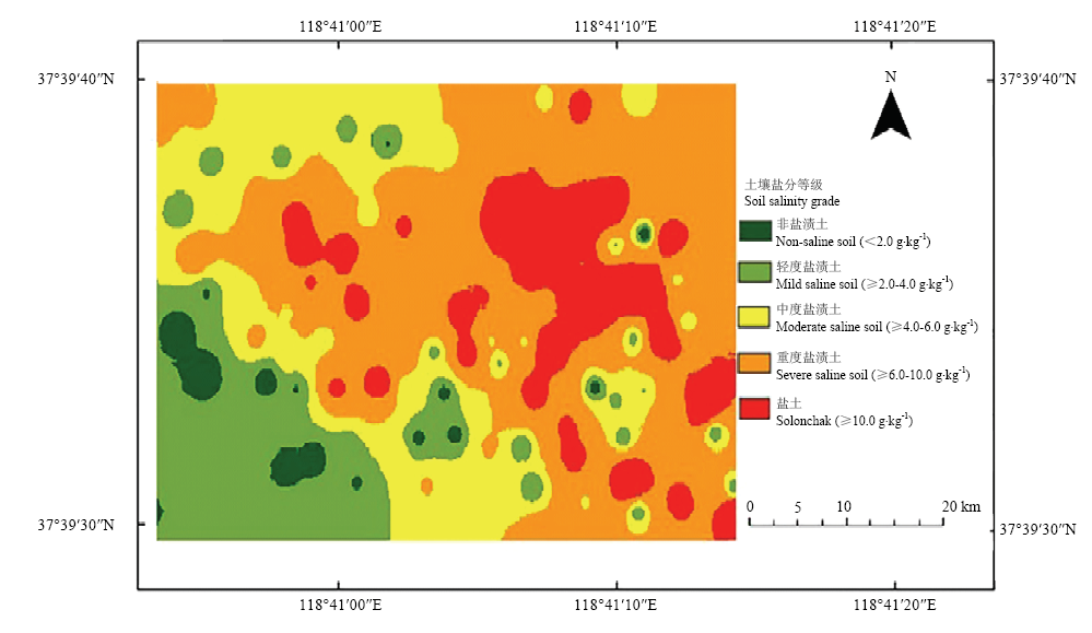
图6
基于反距离加权的土壤盐分插值图"
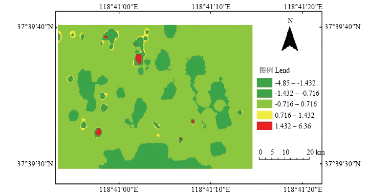
图7
插值结果与反演结果的差值"
| [1] | PARK S H, LEE B R, LEE J H . S nutrition alleviates salt stress by maintaining the assemblage of photosynthetic organelles in Kentucky bluegrass (Poa pratensis L.). Plant Growth Regulation, 2016,79(3):367-375. |
| [2] | 王辉, 高玉录, 于梦, 杜远鹏, 孙永江, 翟衡 . 根灌乙酸及葡萄酒对海水胁迫下葡萄光抑制的影响. 中国农业科学, 2018,51(21):4210-4218. |
| WANG H, GAO Y L, YU M, DU Y P, SUN Y J, ZHAI H . Effect of root irrigation of acetic acid and wine on photoinhibition of grape under seawater stress. Scientia Agricultura Sinica, 2018,51(21):4210-4218. (in Chinese) | |
| [3] |
WHITNEY K, SCUDIERO E, El-ASKARY H M, SKAGGS T H, ALLALI M, CORWIN D L . Validating the use of MODIS time series for salinity assessment over agricultural soils in California, USA. Ecological Indicators, 2018,93:889-898.
doi: 10.1016/j.ecolind.2018.05.069 |
| [4] | 王海江, 蒋天池, YUNGER J A, 李亚莉, 田甜, 王金刚 . 基于支持向量机的土壤主要盐分离子高光谱反演模型. 农业机械学报, 2018,49(5):263-270. |
| WANG H J, JIANG T C, YUNGER J A, LI Y L, TIAN T, WANG J G . Hyperspectral inverse model for soil salt ions based on support vector machine. Transactions of the Chinese Society for Agricultural Machinery, 2018,49(5):263-270. (in Chinese) | |
| [5] |
SRIVASTAVA R, SETHI M, YADAV R K, BUNDELA D S, SINGH M, CHATTARAJ S, SINGH S K, NASRE R A, BISHNOI S R, DHALE S, MOHEKAR D S, BARTHWAL A K . Visible-near infrared reflectance spectroscopy for rapid characterization of salt-affected soil in the Indo-Gangetic plains of Haryana, India. Journal of the Indian Society of Remote Sensing, 2017,45(2):307-315.
doi: 10.1007/s12524-016-0587-0 |
| [6] |
WENG Y L, GONG P, ZHU Z L . Reflectance spectroscopy for the assessment of soil salt content in soils of the Yellow River Delta of China. International Journal of Remote Sensing, 2008,29(19):5511-5531.
doi: 10.1080/01431160801930248 |
| [7] | 张东辉, 赵英俊, 秦凯, 赵宁博, 杨越超 . 光谱变换方法对黑土养分含量高光谱遥感反演精度的影响. 农业工程学报, 2018,34(20):141-147. |
| ZHANG D H, ZHAO Y J, QIN K, ZHAO N B, YANG Y C . Influence of spectral transformation methods on nutrient content inversion accuracy by hyperspectral remote sensing in black soil. Transactions of the Chinese Society of Agricultural Engineering, 2018,34(20):141-147. (in Chinese) | |
| [8] | 朱赟, 申广荣, 项巧巧, 吴裕 . 基于不同光谱变换的土壤盐含量光谱特征分析. 土壤通报, 2017,48(3):560-568. |
| ZHU Y, SHEN G R, XIANG Q Q, WU Y . Spectral characteristics of soil salinity based on different pre-processing methods. Chinese Journal of Soil Science, 2017,48(3):560-568. (in Chinese) | |
| [9] |
XU C, ZENG W Z, HUANG J S, WU J W, LEEUWEN W J V . Prediction of soil moisture content and soil salt concentration from hyperspectral laboratory and field data. Remote Sensing, 2016,8(1):42-62.
doi: 10.3390/rs8010042 |
| [10] |
WIEGAND C L, EVERITT J H, RICHARDSON A J . Comparison of multispectral video and SPOT-1 HRV observations for cotton affected by soil salinity. International Journal of Remote Sensing, 1992,13(8):1511-1525.
doi: 10.1080/01431169208904205 |
| [11] | 张贤龙, 张飞, 张海威, 李哲, 海清, 陈丽华 . 基于光谱变换的高光谱指数土壤盐分反演模型优选. 农业工程学报, 2018,34(1):110-117. |
| ZHANG X L, ZHANG F, ZHANG H W, LI Z, HAI Q, CHEN L H . Optimization of soil salt inversion model based on spectral transformation from hyperspectral index. Transactions of the Chinese Society of Agricultural Engineering, 2018,34(1):110-117. (in Chinese) | |
| [12] |
SCUDIERO E, SKAGGS T H, CORWIN D L . Regional-scale soil salinity assessment using Landsat ETM+ canopy reflectance. Remote Sensing of Environment, 2015,169:335-343.
doi: 10.1016/j.rse.2015.08.026 |
| [13] | 李晋, 赵庚星, 常春艳, 刘海腾 . 基于HSI高光谱和TM图像的土地盐渍化信息提取方法. 光谱学与光谱分析, 2014,34(2):520-525. |
| LI J, ZHAO G X, CHANG C Y, LIU H T . Land salinization information extraction method based on HSI hyperspectral and TM imagery. Spectroscopy and Spectral Analysis, 2014,34(2):520-525. (in Chinese) | |
| [14] | 魏阳, 丁建丽, 王飞 . 基于Landsat OLI的绿洲灌区土壤盐度最优预测尺度分析. 中国农业科学, 2017,50(15):2969-2982. |
| WEI Y, DING J L, WANG F . Optimal scale analysis of soil salinity prediction in oasis irrigated area of arid land based on Landsat OLI. Scientia Agricultura Sinica, 2017,50(15):2969-2982. (in Chinese) | |
| [15] |
SIDIKE A, ZHAO S H, WEN Y M . Estimating soil salinity in Pingluo county of China using QuickBird data and soil reflectance spectra. International Journal of Applied Earth Observation and Geoinformation, 2014,26:156-175.
doi: 10.1016/j.jag.2013.06.002 |
| [16] |
NAWAR S, BUDDENBAUM H, HILL J . Estimation of soil salinity using three quantitative methods based on visible and near-infrared reflectance spectroscopy: A case study from Egypt. Arabian Journal of Geosciences, 2015,8(7):5127-5140.
doi: 10.1007/s12517-014-1580-y |
| [17] |
SCUDIERO E, CORWIN D L, MORARI F, ANDERSON R G, SKAGGS T H . Spatial interpolation quality assessment for soil sensor transect datasets. Computers and Electronics in Agriculture, 2016,123:74-79.
doi: 10.1016/j.compag.2016.02.016 |
| [18] | 扶卿华, 倪绍祥, 王世新, 周艺 . 土壤盐分含量的遥感反演研究. 农业工程学报, 2007,23(1):48-54. |
| FU Q H, NI S X, WANG S X, ZHOU Y . Retrieval of soil salt content based on remote sensing. Transactions of the Chinese Society of Agricultural Engineering, 2007,23(1):48-54. (in Chinese) | |
| [19] | 梁静, 丁建丽, 王敬哲, 王飞 . 基于反射光谱与Landsat 8 OLI多光谱数据的艾比湖湿地土壤盐分估算. 土壤学报, 2018,56(2):1-12. |
| LIANG J, DING J L, WANG J Z, WANG F . Quantitative estimation and mapping of soil salinity in the Ebinur Lake wetland based on Vis-NIR reflectance and Landsat 8 OLI data. Acta Pedologica Sinica, 2019,56(2):1-12. (in Chinese) | |
| [20] |
AMANI M, SALEHI B , MAHDAVIS. Temperature-vegetation-soil moisture dryness index(TVMDI). Remote Sensing of Environment, 2017,197:1-14.
doi: 10.1016/j.rse.2017.05.026 |
| [21] | 汪小钦, 王苗苗, 王绍强, 吴云东 . 基于可见光波段无人机遥感的植被信息提取. 农业工程学报, 2015,31(5):152-159. |
| WANG X Q, WANG M M, WANG S Q, WU Y D . Extraction of vegetation information from visible unmanned aerial vehicle images. Transactions of the Chinese Society of Agricultural Engineering, 2015,31(5):152-159. (in Chinese) | |
| [22] |
HASSANESFAHANI L, TORRESTUA A, JENSEN A . Assessment of surface soil moisture using high-resolution multi-spectral imagery and artificial neural networks. Remote Sensing, 2015,7(3):2627-2646.
doi: 10.3390/rs70302627 |
| [23] | 王海峰, 张智韬, 付秋萍, 陈硕博, 边江, 崔婷 . 低空无人机多光谱遥感数据的土壤含水率反演. 节水灌溉, 2018,43(1):90-94, 102. |
| WANG H F, ZHANG Z T, FU Q P, CHEN S B, BIAN J, CUI T . Inversion of soil moisture content based on multispectral remote sensing data of low-altitude UAV. Water Saving Irrigation, 2018,43(1):90-94, 102. (in Chinese) | |
| [24] | 陈硕博, 陈俊英, 张智韬, 边江, 王禹枫, 石树兰 . 无人机多光谱遥感反演抽穗期冬小麦土壤含水率研究. 节水灌溉, 2018,43(5):39-43. |
| CHEN S B, CHEN J Y, ZHANG Z T, BIAN J, WANG Y F, SHI S L . Retrieving soil water content of winter wheat during heading period by multi-spectral remote sensing of Unmanned Aerial Vehicle (UAV). Water Saving Irrigation, 2018,43(5):39-43. (in Chinese) | |
| [25] |
AASEN H, GNYP M L, MIAO Y X, BARETH G . Automated hyperspectral vegetation index retrieval from multiple correlation matrices with HyperCor. Photogrammetric Engineering and Remote Sensing, 2014,80(8):785-795.
doi: 10.14358/PERS.80.8.785 |
| [26] |
MORELLOS A, PANTAZI X E, MOSHOU D, ALEXANDRIDIS T, WHETTON R, TZIOTZIOS G, WIEBENSOHN J, BILL R, ABDUL M . Machine learning based prediction of soil total nitrogen, organic carbon and moisture content by using VIS-NIR spectroscopy. Biosystems Engineering, 2016,152(12):104-116.
doi: 10.1016/j.biosystemseng.2016.04.018 |
| [27] |
HOFFMANN H, JENSEN R, THOMSEN A, NLETO H, RASMUSSEN J, FRIBORG T . Crop water stress maps for entire growing seasons from visible and thermal UAV imagery. Biogeosciences, 2016,13(24):6545-6563.
doi: 10.5194/bg-13-6545-2016 |
| [28] |
ROSA O C, BAUP F, FABRE S, FIEUZAL R, BRIOTTE X . Improvement of soil moisture retrieval from hyperspectral VNIR- SWIR data using clay content information: From laboratory to field experiments. Remote Sensing, 2015,7(3):3184-3205.
doi: 10.3390/rs70303184 |
| [29] | JIN X L, DU J, LIU H J, WANG Z M, SONG K S . Remote estimation of soil organic matter content in the Sanjiang plain, Northest China: The optimal band algorithm versus the GRA-ANN model. Agricultural and Forest Meteorology, 2016,218(12):250-260. |
| [30] | 张宗玲, 韩增德, 刘立晶, 李晓栋, 郝付平, 董哲 . 玉米穗茎兼收割台夹持输送装置参数优化. 农业机械学报, 2018,49(3):114-121. |
| ZHANG Z L, HAN Z D, LIU L J, LI X D, HAO F P, DONG Z . Parameters optimization for gripping and delivering device of corn harvester for reaping both corn stalk and spike. Transactions of the Chinese Society for Agricultural Machinery, 2018,49(3):114-121. (in Chinese) | |
| [31] | 陈红艳, 赵庚星, 陈敬春, 王瑞燕, 高明秀 . 基于改进植被指数的黄河口区盐渍土盐分遥感反演. 农业工程学报, 2015,31(5):107-114. |
| CHEN H Y, ZHAO G X, CHEN J C, WANG R Y, GAO M X . Remote sensing inversion of saline soil salinity based on modified vegetation index in estuary area of Yellow River. Transactions of the Chinese Society of Agricultural Engineering, 2015,31(5):107-114. (in Chinese) | |
| [32] | 李鑫星, 朱晨光, 周婧, 孙龙清, 曹霞敏, 张小栓 . 光谱技术在水产养殖水质监测中的应用进展及趋势. 农业工程学报, 2018,34(19):184-194. |
| LI X X, ZHU C G, ZHOU J, SUN L Q, CAO X M, ZHANG X S . Review and trend of water quality detection in aquaculture by spectroscopy technique. Transactions of the Chinese Society of Agricultural Engineering, 2018,34(19):184-194. (in Chinese) | |
| [33] |
URSELMANS T T, SCHMIDT H, JOERGENSEN R G, LUDWIG B . Usefulness of near-infrared spectroscopy to determine biological and chemical soil properties: Importance of sample pre-treatment. Soil Biology and Biochemistry, 2008,40(5):1178-1188.
doi: 10.1016/j.soilbio.2007.12.011 |
| [34] | 翁永玲, 宫鹏 . 黄河三角洲盐渍土盐分特征研究. 南京大学学报(自然科学版), 2006,42(6):602-610. |
| WENG Y L, GONG P . Soil salinity measurements on the Yellow River Delta. Journal of Nanjing University (Natural Sciences), 2006,42(6):602-610. (in Chinese) | |
| [35] | 安乐生, 赵全升, 叶思源, 刘贯群, 丁喜桂 . 黄河三角洲地下水关键水盐因子及其植被效应. 水科学展, 2011,22(5):689-695. |
| AN L S, ZHAO Q S, YE S Y, LIU G Q, DING X G . Water-salt interactions factors and vegetation effects in the groundwater ecosystem in Yellow River Delta. Advances in Water Science, 2011,22(5):689-695. (in Chinese) | |
| [36] | BEN-DOR E, GOLDSHLEGER N, ESHEL M, NIRABLIS V, BASON U . Combined active and passive remote sensing methods for assessing soil salinity. Remote Sensing of Soil Salinization, 2008(10):235-255. |
| [37] |
GOLDSHLEGERN, BEN-DOR E, LUGASSI R, ESHEL G . Soil degra-dation monitoring by remote sensing: Examples with three degradation processes. Soil Science Society of America Journal, 2010,74(5):1433-1445.
doi: 10.2136/sssaj2009.0351 |
| [38] | 徐伟杰 . 火星表面模拟矿物和卤水的光谱鉴别研究[D]. 威海:山东大学, 2018. |
| XU W J . Spectral discriminant analysis of martian simulated minerals and brines[D]. Weihai: Shandong University, 2018. (in Chinese) | |
| [39] |
FAN X W, LIU Y B, TAO J M, WENG Y L . Soil salinity retrieval from advanced multi-spectral sensor with partial least square regression. Remote Sensing, 2015,7(1):488-511.
doi: 10.3390/rs70100488 |
| [40] | 翁永玲, 宫鹏 . 土壤盐渍化遥感应用研究进展. 地理科学, 2006,26(3):369-375. |
| WENG Y L, GONG P . A review on remote sensing technique for salt-affected soils. Scientia Georaphica Sinica, 2006,26(3):369-375. (in Chinese) | |
| [41] | 陈文娇 . 基于多源数据光谱转换的土壤盐分反演与动态分析[D]. 南京: 东南大学, 2018. |
| CHEN W J . Soil salinity retrieval and dynamic analysis based on spectral intercalibration of multi-sensor data[D]. Nanjing: Southeast University, 2018. (in Chinese) | |
| [42] | 周鹏, 杨玮, 李民赞, 郑立华, 陈玉青 . 基于灰度关联-极限学习机的土壤全氮预测. 农业机械学报, 2017,48(S1):271-276. |
| ZHOU P, YANG W, LI M Z, ZHENG L H, CHEN Y Q . Soil total nitrogen content prediction based on gray correlation-extreme learning machine. Transactions of the Chinese Society for Agricultural Machinery, 2017,48(S1):271-276. (in Chinese) |
| [1] | 费耀莹, 王迪, 唐伟杰, 郭彩丽, 张小虎, 邱小雷, 程涛, 姚霞, 江冲亚, 朱艳, 曹卫星, 郑恒彪. 基于无人机多源影像融合的水稻籽粒蛋白质含量估测[J]. 中国农业科学, 2026, 59(1): 41-56. |
| [2] | 梁雪, 姜艳, 危常州, 薛冰, 李芳芳, 崔怡蕊, 张夏然. 基于无人机遥感的玉米农田土壤水分诊断模型研究[J]. 中国农业科学, 2025, 58(23): 4979-4992. |
| [3] | 雷鸣阔, 查燕, 王丽, 程钢, 温彩运, 尹作堂, 陆苗. 基于无人机影像分层建模的土壤深层盐渍化空间预测[J]. 中国农业科学, 2025, 58(20): 4070-4084. |
| [4] | 邵明超, 安敬威, 刘博睿, 吴建双, 张琪, 姚霞, 程涛, 江冲亚, 曹卫星, 郑恒彪, 朱艳. 基于多模态数据的小麦苗情综合评估研究[J]. 中国农业科学, 2025, 58(19): 3857-3871. |
| [5] | 韩林蒲, 马纪龙, 齐勇杰, 高嘉琪, 谢铁娜, 贾彪. 无人机多光谱参数与Shapley分析融合的青贮玉米生物量估算[J]. 中国农业科学, 2025, 58(18): 3632-3647. |
| [6] | 何豪旭, 高祥, 饶元, 张子睿, 吴巩, 侯依廷, 何烨, 厉心怡. 基于改进YOLOv8s的小麦苗期叶尖检测方法[J]. 中国农业科学, 2025, 58(18): 3598-3615. |
| [7] | 臧少龙, 刘淋茹, 高越之, 吴珂, 贺利, 段剑钊, 宋晓, 冯伟. 基于无人机影像多时相的小麦品种氮效率分类识别[J]. 中国农业科学, 2024, 57(9): 1687-1708. |
| [8] | 周智辉, 谷晓博, 程智楷, 常甜, 赵彤彤, 王玉明, 杜娅丹. 基于影像分割的覆膜玉米叶绿素含量反演[J]. 中国农业科学, 2024, 57(6): 1066-1079. |
| [9] | 运彬媛, 谢铁娜, 李虹, 岳翔, 吕明玥, 王佳琦, 贾彪. 融合无人机光谱与纹理信息的玉米氮素营养估测[J]. 中国农业科学, 2024, 57(16): 3154-3170. |
| [10] | 石浩磊, 曹红霞, 张伟杰, 朱珊, 何子建, 张泽. 基于无人机多光谱的棉花多生育期叶面积指数反演[J]. 中国农业科学, 2024, 57(1): 80-95. |
| [11] | 魏永康, 杨天聪, 臧少龙, 贺利, 段剑钊, 谢迎新, 王晨阳, 冯伟. 基于无人机多光谱影像特征融合的小麦倒伏监测[J]. 中国农业科学, 2023, 56(9): 1670-1685. |
| [12] | 郭燕, 井宇航, 王来刚, 黄竞毅, 贺佳, 冯伟, 郑国清. 基于无人机影像特征的冬小麦植株氮含量预测及模型迁移能力分析[J]. 中国农业科学, 2023, 56(5): 850-865. |
| [13] | 王伟康, 张嘉懿, 汪慧, 曹强, 田永超, 朱艳, 曹卫星, 刘小军. 基于固定翼无人机多光谱影像的水稻长势关键指标无损监测[J]. 中国农业科学, 2023, 56(21): 4175-4191. |
| [14] | 侯化刚, 王丹阳, 马斯琦, 潘剑君, 李兆富. 黄河三角洲不同盐渍度土壤有机质含量的高光谱预测研究[J]. 中国农业科学, 2023, 56(10): 1905-1919. |
| [15] | 冯子恒,宋莉,张少华,井宇航,段剑钊,贺利,尹飞,冯伟. 基于无人机多光谱和热红外影像信息融合的小麦白粉病监测[J]. 中国农业科学, 2022, 55(5): 890-906. |
|
||