


中国农业科学 ›› 2020, Vol. 53 ›› Issue (9): 1795-1805.doi: 10.3864/j.issn.0578-1752.2020.09.008
史丰智1,2,王瑞燕1,2( ),李玉环1,2,闫宏3,张晓鑫1
收稿日期:2019-08-23
接受日期:2020-03-07
出版日期:2020-05-01
发布日期:2020-05-13
通讯作者:
王瑞燕
作者简介:史丰智,E-mail:1204944751@qq.com。
基金资助:
FengZhi SHI1,2,RuiYan WANG1,2(),YuHuan LI1,2,Hong YAN3,XiaoXin ZHANG1
Received:2019-08-23
Accepted:2020-03-07
Online:2020-05-01
Published:2020-05-13
Contact:
RuiYan WANG
摘要:
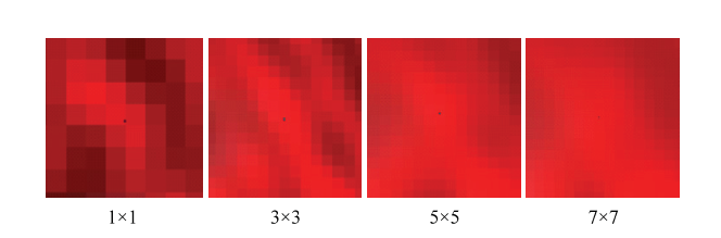
【目的】植被产量能综合直观地反映盐渍土改良效果,冬小麦生长旺盛期的叶面积指数(LAI)是植被产量的常用衡量指标。本研究利用无人机多光谱遥感获取冬小麦生长旺盛期的叶面积指数分布数据,对盐渍土改良效果进行客观准确评价,为人们筛选盐渍土改良技术和产品提供科学指导。【方法】以无棣县渤海粮仓滨海盐渍土改良试验区为研究区,基于无人机多光谱遥感数据,利用线性回归分析、偏最小二乘、随机森林和支持向量机等方法,构建拔节期冬小麦LAI反演模型;并利用因子分析法对盐渍土地区抽样地块进行改良效果评价,建立盐渍土改良效果LAI评价模型,基于该评价模型对整个试验区盐渍土改良效果进行评价。【结果】对冬小麦LAI遥感估测而言,并不是分辨率越高越好,而是5×5均值平滑后的光谱数据与一垄小麦叶面积指数的对应最佳。LAI遥感估测模型中,利用支持向量机建立的模型精度最高。改良效果LAI评价模型的预测结果表明,LAI对盐渍土改良效果的预测精度较高,改良效果最优地块的编号为26、27、28、29、30和31,最优改良方法为引黄淤灌和增施有机肥综合改良措施。【结论】无人机遥感可对盐渍土地区拔节期冬小麦的叶面积指数进行准确反演,基于LAI反演结果的盐渍土改良效果评价能够从众多试验小区中定位出最优的改良效果。与传统方法相比,该方法具有成本低廉、精度高等优势,研究结果有广泛推广前景,可以为盐渍土的改良提供重要技术支持。
史丰智,王瑞燕,李玉环,闫宏,张晓鑫. LAI无人机多光谱遥感估测及其在盐渍土改良中的应用[J]. 中国农业科学, 2020, 53(9): 1795-1805.
FengZhi SHI,RuiYan WANG,YuHuan LI,Hong YAN,XiaoXin ZHANG. LAI Estimation Based on Multi-Spectral Remote Sensing of UAV and Its Application in Saline Soil Improvement[J]. Scientia Agricultura Sinica, 2020, 53(9): 1795-1805.
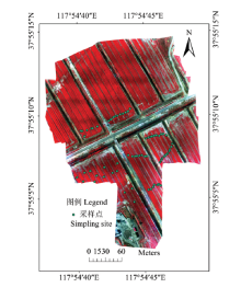
图1
试验区范围与采样点"

表1
不同滤波窗口处理后的特征波段与LAI相关性"
| 不同窗口 Different window | 波段名称Band name | ||||||
|---|---|---|---|---|---|---|---|
| 1×1 | 2×2 | 3×3 | 4×4 | 5×5 | 6×6 | 7×7 | |
| 绿光GRE | -0.53** | -0.54** | -0.54** | -0.58** | -0.57** | -0.58** | -0.58** |
| 红光RED | -0.58** | -0.60** | -0.59** | -0.60** | -0.61** | -0.59** | -0.61** |
| 红边REG | -0.18 | -0.19 | -0.25* | -0.32** | -0.34** | -0.43** | -0.38** |
| 近红NIR | 0.55** | 0.55** | 0.53** | 0.47** | 0.49** | 0.38** | 0.45** |
表2
植被指数计算公式"
| 植被指数 Vegetation index | 计算公式 Calculation formula |
|---|---|
| 归一化植被指数 NDVI[ | NDVI=(ρnir-ρred)/(ρnir+ρred) |
| 比值植被指数 RVI[ | RVI=ρnir/ρred |
| 绿度归一化植被指数 GNDVI[ | GNDVI=(ρnir-ρgre)/(ρnir+ρgre) |
| 绿色比值植被指数 GRVI[ | GRVI=ρnir/ρgre |
表3
不同滤波处理后光谱指数与叶面积指数相关性"
| 不同窗口 Different window | 植被指数 Vegetation index | ||||||
|---|---|---|---|---|---|---|---|
| 1×1 | 2×2 | 3×3 | 4×4 | 5×5 | 6×6 | 7×7 | |
| NDVI | 0.62** | 0.66** | 0.64** | 0.66** | 0.67** | 0.62** | 0.67** |
| RVI | 0.78** | 0.80** | 0.81** | 0.81** | 0.82** | 0.79** | 0.79** |
| GNDVI | 0.59** | 0.63** | 0.62** | 0.67** | 0.66** | 0.63** | 0.67** |
| GRVI | 0.75** | 0.79** | 0.77** | 0.79** | 0.79** | 0.77** | 0.79** |
| (G+R)/NIR | 0.55** | 0.58** | 0.57** | 0.60** | 0.60** | 0.56** | 0.61** |
表4
植被指数与LAI建模与验证"
| 建模集Modeling set (n=44) | 验证集Validation set (n=19) | |||||||
|---|---|---|---|---|---|---|---|---|
| 多元线性回归 Multiple linear regression | 偏最小二乘 PLS | 支持向量机 SVM | 随机森林 RF | 多元线性回归 Multiple linear regression | 偏最小二乘 PLS | 支持向量机 SVM | 随机森林 RF | |
| R2 | 0.84 | 0.75 | 0.85 | 0.94 | 0.69 | 0.66 | 0.62 | 0.56 |
| RMSE | 0.51 | 0.63 | 0.48 | 0.32 | 0.66 | 0.67 | 0.74 | 0.79 |
| RPD | 2.30 | 1.70 | 2.40 | 3.50 | 1.40 | 1.50 | 1.30 | 1.20 |
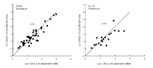
图2
冬小麦LAI实测值与预测值比较"

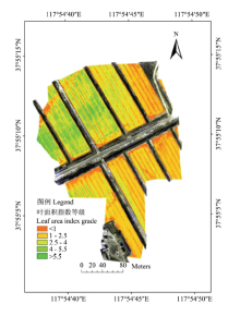
图3
叶面积指数等级分布图"

表5
总方差分析"
| 成分Ingredient | 初始特征值Initial eigenvalue | 提取载荷平方和Extract load sum of squares | 旋转载荷平方和Sum of rotation load squares | ||||||
|---|---|---|---|---|---|---|---|---|---|
| 总计 Total | 方差百分比 Variance percentage | 累积 Accumulation (%) | 总计 Total | 方差百分比 Variance percentage (%) | 累积Accumulation (%) | 总计 Total | 方差百分比 Variance percentage | 累积 Accumulation (%) | |
| 1 | 2.330 | 58.248 | 58.248 | 2.330 | 58.248 | 58.248 | 2.114 | 52.852 | 52.852 |
| 2 | 0.959 | 23.987 | 82.235 | 0.959 | 23.987 | 82.235 | 1.175 | 29.383 | 82.235 |
| 3 | 0.458 | 11.445 | 93.680 | ||||||
| 4 | 0.253 | 6.320 | 100.000 | ||||||
表6
成分得分矩阵"
| 成分1 Ingredient 1 | 成分2 Ingredient 2 | |
|---|---|---|
| 有机质Organic matter | 0.411 | -0.023 |
| 盐分Salinity | -0.275 | -0.260 |
| 含氮量Nitrogen content | 0.502 | -0.263 |
| 水分Moisture | -0.171 | 0.899 |
表7
各地块得分情况排名"
| 地块编号 Parcel number | 得分 Score | LAI | 排名 Ranking | 地块编号 Parcel number | 得分 Score | LAI | 排名 Ranking | 地块编号 Parcel number | 得分 Score | LAI | 排名 Ranking | ||
|---|---|---|---|---|---|---|---|---|---|---|---|---|---|
| 6 | 0.67 | 4.76 | 1 | 9 | 0.42 | 2.35 | 7 | 12 | 0.33 | 1.55 | 12 | ||
| 1 | 0.59 | 3.84 | 2 | 15 | 0.42 | 2.40 | 6 | 13 | 0.32 | 1.88 | 11 | ||
| 8 | 0.49 | 2.81 | 4 | 10 | 0.39 | 2.51 | 8 | 16 | 0.22 | 1.70 | 13 | ||
| 5 | 0.48 | 3.24 | 3 | 18 | 0.34 | 2.19 | 9 | 17 | 0.02 | 1.39 | 14 | ||
| 11 | 0.46 | 2.66 | 5 | 14 | 0.33 | 1.76 | 10 |
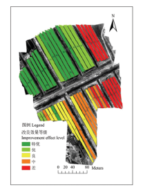
图4
试验田改良效果等级划分图"

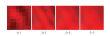
图5
4种窗口滤波处理后的假彩色合成无人机影像(黑点为采样点)"
| [1] | 季洪亮, 路艳 . 滨海盐碱地生态修复效果评价. 西北林学院学报, 2017(2):301-307. |
| JI H L, LU Y . Evaluation of the eco-restoration effect on coastal saline-alkali soil. Journal of Northwest Forestry University, 2017(2):301-307. (in Chinese) | |
| [2] | 许经勇, 黄焕文 . 有关我国粮食安全的几个问题研究. 财经研究, 2004,30(5):122-129. |
| XU J Y, HUANG H W . A Study on the issue of food security in China. Journal of Finance and Economics, 2004,30(5):122-129. (in Chinese) | |
| [3] | 刘东兴, 宫伟光 . 大庆盐碱地立地质量评价. 中国水土保持科学, 2009,3(3):98-103. |
| LIU D X, GONG W G . Evaluation of site quality for saline-alkali soil in Daqing. Science of Soil and Water Conservation, 2009,3(3):98-103. (in Chinese) | |
| [4] | 刘杰 . 不同盐碱土改良剂在棉花上的应用效果初报. 新疆农垦科技, 2015(7):73-74. |
| LIU J . Preliminary report on the application effect of different saline-alkaline soil improvers on cotton. Xinjiang Farm Research of Science and Technology, 2015(7):73-74. (in Chinese) | |
| [5] | 何小安 . 基于无人机遥感影像的冬小麦播种效果与空间变异评价[D]. 西安: 西安科技大学, 2018. |
| HE X A . Evaluation of sowing effect and spatial variation in winter wheat based on unmanned aerial vehicle remote sensing images[D]. Xi’an: Xi’an University of Science and Technology, 2018. (in Chinese) | |
| [6] | 杨贵军, 李长春, 于海洋, 徐波, 冯海宽, 高林, 朱冬梅 . 农用无人机多传感器遥感辅助小麦育种信息获取. 农业工程学报, 2015,31(21):184-190. |
| YANG G J, LI C C, YU H Y, XU B, FENG H K, GAO L, ZHU D M . UAV based multi-load remote sensing technologies for wheat breeding information acquirement. Transactions of the Chinese Society of Agricultural Engineering, 2015,31(21):184-190. (in Chinese) | |
| [7] |
高林, 杨贵军, 王宝山, 于海洋, 徐波, 冯海宽 . 基于无人机遥感影像的大豆叶面积指数反演研究. 中国生态农业学报, 2015,23(7):868-876.
pmid: 19662996 |
|
GAO L, YANG G J, WANG B S, YU H Y, XU B, FENG H K . Soybean leaf area index retrieval with UAV remote sensing imagery. Chinese Journal of Eco-Agriculture, 2015,23(7):868-876. (in Chinese)
pmid: 19662996 |
|
| [8] |
DUAN B, LIU Y, GONG Y, PENG Y, WANG X, ZHU R, FANG S H . Remote estimation of rice LAI based on Fourier spectrum texture from UAV image. Plant Methods, 2019,15(1):1-12.
doi: 10.1186/s13007-019-0507-8 pmid: 31695729 |
| [9] | 张春兰, 杨贵军, 李贺丽, 汤伏全, 刘畅, 张丽妍 . 基于随机森林算法的冬小麦叶面积指数遥感反演研究. 中国农业科学, 2018,51(5):855-867. |
| ZHANG C L, YANG G J, LI H L, TANG F Q, LIU C, ZHANG L Y . Remote sensing inversion of leaf area index of winter wheat based on random forest algorithm. Scientia Agricultura Sinica, 2018,51(5):855-867. (in Chinese) | |
| [10] | 褚洪亮, 肖青, 柏军华, 程娟 . 基于无人机遥感的叶面积指数反演. 遥感技术与应用, 2017,32(1):140-148. |
| CHU H L, XIAO Q, BAI J H, CHENG J . The retrieval of leaf area index based on remote sensing by unmanned aerial vehicle. Remote Sensing Technology and Application, 2017,32(1):140-148. (in Chinese) | |
| [11] | 李长春, 牛庆林, 杨贵军, 冯海宽, 刘建刚, 王艳杰 . 基于无人机数码影像的大豆育种材料叶面积指数估测. 农业机械学报, 2017,48(8):147-158. |
| LI C C, NIU Q L, YANG G J, FENG H K, LIU J G, WANG Y J . Estimation of leaf area index of soybean breeding materials based on UAV digital images. Transactions of the Chinese Society for Agricultural Machinery, 2017,48(8):147-158. (in Chinese) | |
| [12] | 顾婷, 高晓雯, 孙成明, 王燕君, 刘涛, 武威, 陈雯 . 基于无人机图像的水稻拔节期叶面积指数估算. 农业网络信息, 2015(12):63-65. |
| GU T, GAO X W, SUN C M, WANG Y J, LIU T, WU W, CHEN W . Estimation on the rice leaf area index in jointing stage based on unmanned aerial vehicle (UAV) image. Agriculture Network Information, 2015(12):63-65. (in Chinese) | |
| [13] | 雷亚平, 韩迎春, 杨北方, 王康丽, 王国平, 冯璐, 王占彪, 李亚兵 . 利用无人机数字图像监测不同棉花品种叶面积指数. 中国棉花, 2018,45(12):9-15. |
| LEI Y P, HAN Y C, YANG B F, WANG K L, WANG G P, FENG L, WANG Z B, LI Y B . Monitoring of leaf area index of different cotton varieties using UAV-acquired digital images. China Cotton, 2018,45(12):9-15. (in Chinese) | |
| [14] | 李子扬, 钱永刚, 申庆丰, 王宁, 刘耀开, 马灵玲, 孔祥生 . 基于高光谱数据的叶面积指数遥感反演. 红外与激光工程, 2014,43(3):944-949. |
| YANG Z Y, QIAN Y G, SHEN Q F, WANG N, LIU Y K, MA L L, KONG X S . Leaf area index retrieval from remotely sensed hyperspectral data. Infrared and Laser Engineering, 2014,43(3):944-949. (in Chinese) | |
| [15] | 田明璐, 班松涛, 常庆瑞, 由明明, 罗丹, 王力, 王烁 . 基于低空无人机成像光谱仪影像估算棉花叶面积指数. 农业工程学报, 2016,32(21):102-108. |
| TIAN M L, BAN S T, CHANG Q R, YOU M M, LUO D, WANG L, WANG S . Use of hyperspectral images from UAV-based imaging spectroradiometer to estimate cotton leaf area index. Transactions of the Chinese Society of Agricultural Engineering, 2016,32(21):102-108. (in Chinese) | |
| [16] |
LIU K, ZHOU Q B, WU W B, XIA T, TANG H J . Estimating the crop leaf area index using hyperspectral remote sensing. Journal of Integrative Agriculture, 2016,15(2):475-491.
doi: 10.2134/jeq2005.0204 pmid: 16738391 |
| [17] |
ROOSJEN P P J, BREDE B, SUOMALAINEN J M, BARTHOLOMEUS H M, KOOISTRA L, CLEVERS J G P W . Improved estimation of leaf area index and leaf chlorophyll content of a potato crop using multi-angle spectral data-potential of unmanned aerial vehicle imagery. International Journal of Applied Earth Observation and Geoinformation, 2018,66:14-26.
doi: 10.1016/j.jag.2017.10.012 |
| [18] | 高林, 杨贵军, 李红军, 李振海, 冯海宽, 王磊, 董锦绘, 贺鹏 . 基于无人机数码影像的冬小麦叶面积指数探测研究. 中国生态农业学报, 2016,24(9):1254-1264. |
| GAO L, YANG G J, LI H J, LI Z H, FENG H K, WANG L, DONG J H, HE P . Winter wheat LAI estimation using unmanned aerial vehicle RGB-imaging. Chinese Journal of Eco-Agriculture, 2016,24(9):1254-1264. (in Chinese) | |
| [19] | 罗建美, 靳根会, 罗仲朋, 王红营, 齐永青, 刘兴冉, 沈彦俊 . 河北平原中低产区小麦与玉米生产现状及增产潜力分析. 中国生态农业学报, 2016,24(8):1123-1134. |
| LUO J M, JIN G H, LUO Z P, WANG H Y, QI Y Q, LIU X R, SHEN Y J . Production state and yield potential of wheat and maize in low-medium yield farmlands in Hebei plain. Chinese Journal of Eco-Agriculture, 2016,24(8):1123-1134. (in Chinese) | |
| [20] |
SAKAMOTO T, SHIBAYAMA M, KIMURA A, TAKADA E . Assessment of digital camera-derived vegetation indices in quantitative monitoring of seasonal rice growth. ISPRS Journal of Photogrammetry and Remote Sensing, 2011,66(6):872-882.
doi: 10.1016/j.isprsjprs.2011.08.005 |
| [21] | 刘昌华, 王哲, 陈志超, 周兰, 岳学智, 苗宇新 . 基于无人机遥感影像的冬小麦氮素监测. 农业机械学报, 2018(6):207-214. |
| LIU C H, WANG Z, CHEN Z C, ZHOU L, YUE X Z, MIAO Y X . Nitrogen monitoring of winter wheat based on unmanned aerial vehicle remote sensing image. Transactions of the Chinese Society of Agricultural Machinery, 2018(6):207-214. | |
| [22] | CAO C, DANG H, KEJIANG L I, JUNYONG M A, ZHENG C . Winter wheat salt tolerance appraisal indices with varied mineral content of saline water. Agricultural Science & Technology, 2014,15(7):1134-1139. |
| [23] | 姚宇, 朱昌达 . “渤海粮仓”典型区土壤养分时空变异. 中国人口·资源与环境, 2018,28(S1):165-168. |
| YAO Y, ZHU C D . Spatio-temporal variability of soil characteristics of the ‘Bohai Granary’ typical area. China Population, Resources and Environment, 2018,28(S1):165-168. (in Chinese) | |
| [24] |
申艳, 张晓平, 梁爱珍, 时秀焕, 范如芹, 杨学明 . 近红外光谱分析法测定东北黑土有机碳和全氮含量. 应用生态学报, 2010,21(1):109-114.
pmid: 20387431 |
|
SHEN Y, ZHANG X P, LAING A Z, SHI X H, FAN R Q, YANG X M . Near infrared spectroscopy in determining organic carbon and total nitrogen in black soil of Northeast China. Chinese Journal of Applied Ecology, 2010,21(1):109-114. (in Chinese)
pmid: 20387431 |
|
| [25] | HUETE A, DIDAN K, MIURA T, RODRIGUEZ E P, GAO X, FERREIRA L G . Overview of the radiometric and biophysical performance of the MODIS vegetation indices. Remote Sensing of Environment, 2002,83(1/2):195-213. |
| [26] | GITELSON A A, KAUFAMAN Y J, MERZLYAK M N . Use of a green channel in remote sensing of global vegetation from EOS-MODIS. Remote Sensing of Environment, 1996,58(3):289-298. |
| [27] | SHIBAYAMA M T, AKIYAMA T . Seasonal visible, near-infrared and mid-infrared spectra of rice canopies in relation to LAI and above-ground dry phytomass. Remote Sensing of Environment, 1989,27(2):119-127. |
| [28] | MOTOHKA T, NASAHARS K N, OGUMA H, TSUCHIDA S . Applicability of green-red vegetation index for remote sensing of vegetation phenology. Remote Sensing, 2010,2(10):2369-2387. |
| [29] | 夏天, 吴文斌, 周清波, 周勇 . 冬小麦叶面积指数高光谱遥感反演方法对比. 农业工程学报, 2013(3):139-147. |
| XIA T, WU W B, ZHOU Q B, ZHOU Y . Comparison of two inversion methods for winter wheat leaf area index based on hyperspectral remote sensing. Transactions of the Chinese Society of Agricultural Engineering, 2013(3):139-147. (in Chinese) | |
| [30] | 郑踊谦, 董恒, 张城芳, 黄鹏 . 植被指数与作物叶面积指数的相关关系研究. 农机化研究, 2019,41(10):7-12. |
| ZHENG Y Q, DONG H, ZHANG C F, HUANG P . Study on the relationship between vegetation indices and leaf area index of crop. Journal of Agricultural Mechanization Research, 2019,41(10):7-12. (in Chinese) | |
| [31] | 刘思汝, 石伟琦, 马海洋, 王国安, 陈清, 徐明岗 . 果树水肥一体化高效利用技术研究进展. 果树学报, 2019,36(3):366-384. |
| LIU S R, SHI W Q, MA H Y, WANG G A, CHEN Q, XU M G . Advances in research on efficient utilization of fertigation in fruit trees. Journal of Fruit Science, 2019,36(3):366-384. (in Chinese) |
| [1] | 陈杨,王磊,白由路,卢艳丽,倪露,王玉红,徐孟泽. 有效积温与不同氮磷钾处理夏玉米株高和叶面积指数定量化关系[J]. 中国农业科学, 2021, 54(22): 4761-4777. |
| [2] | 程彬,刘卫国,王莉,许梅,覃思思,卢俊吉,高阳,李淑贤,AliRAZA,张熠,IrshanAHMAD,敬树忠,刘然金,杨文钰. 种植密度对玉米-大豆带状间作下大豆光合、产量及茎秆抗倒的影响[J]. 中国农业科学, 2021, 54(19): 4084-4096. |
| [3] | 文明, 李明华, 蒋家乐, 马学花, 李容望, 赵文青, 崔静, 刘扬, 马富裕. 氮磷钾运筹模式对北疆滴灌棉花生长发育和产量的影响[J]. 中国农业科学, 2021, 54(16): 3473-3487. |
| [4] | 侯佳敏,罗宁,王溯,孟庆锋,王璞. 增密对我国玉米产量-叶面积指数-光合速率的影响[J]. 中国农业科学, 2021, 54(12): 2538-2546. |
| [5] | 孙乾,顾晓鹤,孙林,王淼,周龙飞,杨贵军,李卫国,束美艳. 不同灌溉条件下冬小麦冠层含水量的光谱响应[J]. 中国农业科学, 2019, 52(14): 2425-2435. |
| [6] | 聂志刚,李广,王钧,马维伟,雒翠萍,董莉霞,逯玉兰. 基于APSIM模型旱地小麦叶面积指数相关参数的优化[J]. 中国农业科学, 2019, 52(12): 2056-2068. |
| [7] | 王虎兵, 曹红霞, 郝舒雪, 潘小燕. 温室番茄植株养分和光合对水肥耦合的响应及其与产量关系[J]. 中国农业科学, 2019, 52(10): 1761-1771. |
| [8] | 陈鹏飞,李刚,石雅娇,徐志涛,杨粉团,曹庆军. 一款无人机高光谱传感器的验证及其在玉米叶面积指数反演中的应用[J]. 中国农业科学, 2018, 51(8): 1464-1474. |
| [9] | 张春兰,杨贵军,李贺丽,汤伏全,刘畅,张丽妍. 基于随机森林算法的冬小麦叶面积指数遥感反演研究[J]. 中国农业科学, 2018, 51(5): 855-867. |
| [10] | 束美艳, 顾晓鹤, 孙林, 朱金山, 杨贵军, 王延仓, 张丽妍. 基于新型植被指数的冬小麦LAI高光谱反演[J]. 中国农业科学, 2018, 51(18): 3486-3496. |
| [11] | 韩雪1, 2, 王力1, 2, 王艳萍1. 自然降雨条件下夏玉米冠层截留特征及影响因素[J]. 中国农业科学, 2014, 47(8): 1541-1549. |
| [12] | 顾蕴倩, 刘雪, 张巍, 亓春杰, 汤开磊, 赵杨, 张岩, 李刚, 王斌, 赵春江, 罗卫红. 灌浆期弱光逆境对小麦生长和产量影响的模拟模型[J]. 中国农业科学, 2013, 46(5): 898-908. |
| [13] | 梁亮, 张连蓬, 林卉, 李春梅, 杨敏华. 基于导数光谱的小麦冠层叶片含水量反演[J]. 中国农业科学, 2013, 46(1): 18-29. |
| [14] | 李鑫川, 徐新刚, 鲍艳松, 黄文江, 罗菊花, 董莹莹, 宋晓宇, 王纪华. 基于分段方式选择敏感植被指数的冬小麦叶面积指数遥感反演[J]. 中国农业科学, 2012, 45(17): 3486-3496. |
| [15] | 夏天, 吴文斌, 周清波, 周勇, 于雷. 基于高光谱的冬小麦叶面积指数估算方法[J]. 中国农业科学, 2012, 45(10): 2085-2092. |
|
||