


中国农业科学 ›› 2023, Vol. 56 ›› Issue (9): 1670-1685.doi: 10.3864/j.issn.0578-1752.2023.09.005
魏永康( ), 杨天聪, 臧少龙, 贺利, 段剑钊(), 谢迎新, 王晨阳, 冯伟()
收稿日期:2022-08-11
接受日期:2022-12-06
出版日期:2023-05-01
发布日期:2023-05-10
通信作者:
段剑钊,E-mail:djz20008@163.com。冯伟,E-mail:fengwei78@126.com
联系方式:
魏永康,E-mail:wei3239125498@163.com。
基金资助:
WEI YongKang(), YANG TianCong, ZANG ShaoLong, HE Li, DUAN JianZhao(), XIE YingXin, WANG ChenYang, FENG Wei()
Received:2022-08-11
Accepted:2022-12-06
Published:2023-05-01
Online:2023-05-10
摘要:
【目的】小麦倒伏严重影响小麦光合及成熟进程,进而造成小麦减产及品质下降。为快速精确获取倒伏信息,评估无人机遥感监测小麦倒伏的能力,构建小麦倒伏监测模式,为灾情评估、保险理赔及灾后补救提供技术支持。【方法】利用近地无人机获取包含红、绿、蓝、红边和近红外5个多光谱波段图像,经过预处理飞行高度50 m的小麦冠层图像,得到分辨率为1.85(cm/像素)的数字正射影像图(DOM)和数字表面模型(DSM),从中提取光谱特征、高度特征和光谱纹理共3类特征信息;采用支持向量机(SVM)和随机森林(RF)2种分类器对6种不同特征集组合进行倒伏分类比较,使用准确率(Acc)、精确率(Pre)、召回率(Re)和调和平均数(F1)以确定较优的特征组合和分类器;同时使用3种不同的特征集筛选方法(套索算法Lasso、随机森林递归算法RF-RFE和Boruta算法)对优化的特征子集进行综合评价,确立适宜的倒伏分类评价方法。【结果】单一特征的光谱和纹理及其组合对小麦倒伏的分类评价结果较差,“椒盐现象”严重,在此基础上融合DSM信息的分类精度显著提高。采用随机森林分类器对光谱特征、纹理特征和高度特征进行特征集组合,小麦倒伏识别的分类准确率最高达91.48%。为减少特征集变量数量,采用3种特征优化方法,与筛选得到的全特征集、Lasso算法、RF-RFE算法相比,基于Boruta算法得到的优化特征子集分类精度更高,整体稳定性更好,从含有DSM的3种特征组合均值来看,总体分类精度和Kappa系数分别提高了0.17%和0.01(全特征集)、2.45%和0.05(Lasso)、2.87%和0.05(RF-RFE)。其中,光谱-纹理-DSM组合效果最好,总体分类精度达92.82%,Kappa系数达0.86。【结论】Boruta算法有效优化光谱-纹理-DSM组合的特征子集数量,让更少的特征参量参与分类,且获得较高的分类精度,确立了精确监测小麦倒伏的多特征组合-Boruta-RFC技术融合模式,为小麦灾情评估及补救措施制定提供参考。
魏永康, 杨天聪, 臧少龙, 贺利, 段剑钊, 谢迎新, 王晨阳, 冯伟. 基于无人机多光谱影像特征融合的小麦倒伏监测[J]. 中国农业科学, 2023, 56(9): 1670-1685.
WEI YongKang, YANG TianCong, ZANG ShaoLong, HE Li, DUAN JianZhao, XIE YingXin, WANG ChenYang, FENG Wei. Monitoring Wheat Lodging Based on UAV Multi-Spectral Image Feature Fusion[J]. Scientia Agricultura Sinica, 2023, 56(9): 1670-1685.
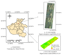
图1
研究区位置"
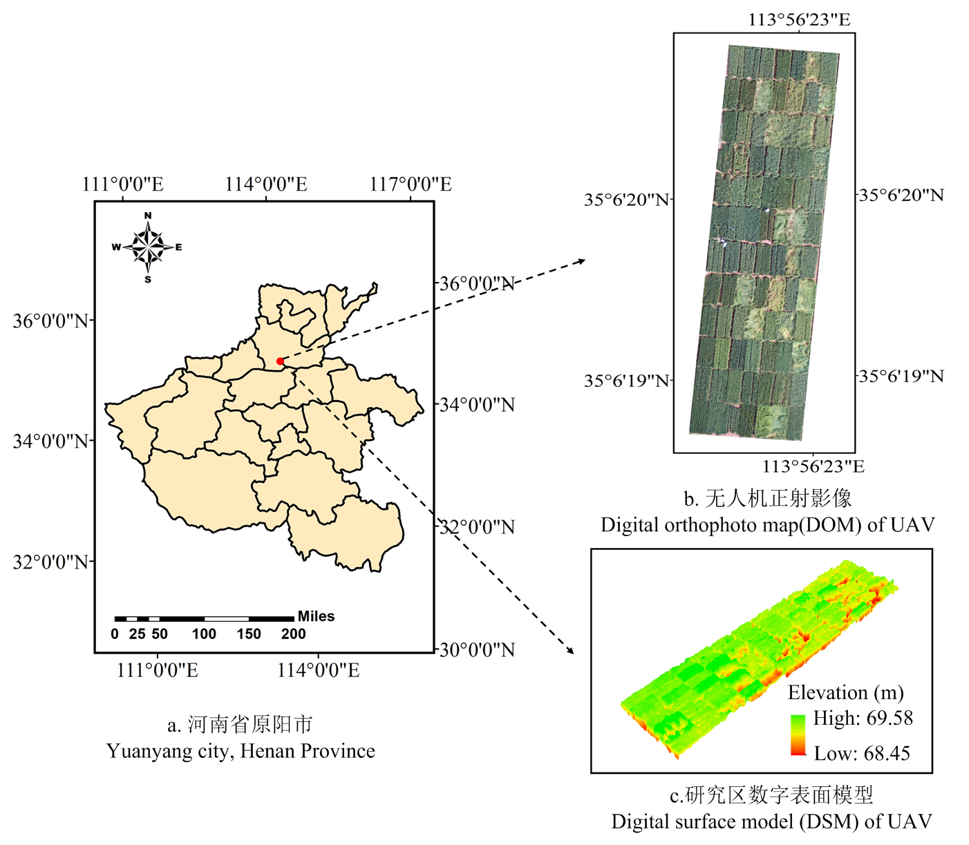
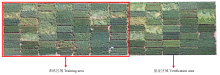
图2
研究区域划分示意图"

图3
技术路线"

表1
本研究中使用的植被指数"
| 植被指数 Vegetation index | 公式 Formula | 参考文献 Reference |
|---|---|---|
| 差值植被指数 DVI Difference vegetation index | Rred.edge-Rred | [ |
| 归一化植被指数 NDVI Normalized difference vegetation index | (Rnir-Rred)/(Rnir-Rred) | [ |
| 比值植被指数 RVI Ratio vegetation index | Rnir/Rred | [ |
| 优化型土壤调节植被指数 OSAVI Optimized soil adjust vegetation index | (1+0.6)(Rnir-Rred)/(Rnir+Rred+0.16) | [ |
| 绿度叶绿素植被指数GCI Green chlorophyll vegetation index | (Rnir/Rgreen)-1 | [ |
| 绿度宽波段植被指数GWDRVI Green wide band vegetation index | 0.9/1.1+(0.1×Rnir- Rgreen)/(0.1×Rnir+Rgreen) | [ |
| 非线性植被指数NLI Nonlinear vegetation index | (Rnir2- Rred)/(Rnir2+Rred) | [ |
| 红边归一化植被指数RENDVI Normalized vegetation index with red edge | (Rred.edge-Rred)/(Rred.edge+Rred) | [ |
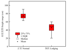
图4
小麦倒伏与未倒伏区域的地物高程范围比较"
表2
光谱特征统计分析"
| 光谱特征 Spectral feature | 倒伏小麦Lodging wheat | 正常小麦 Normal wheat | ||
|---|---|---|---|---|
| 均值 Mean (MN) | 标准差 Standard deviation (SD) | 均值 Mean (MN) | 标准差 Standard deviation (SD) | |
| 蓝光 Blue | 0.0292 | 0.0055 | 0.0173 | 0.0037 |
| 绿光 Green | 0.1315 | 0.0253 | 0.0733 | 0.0184 |
| 红光 Red | 0.2134 | 0.0366 | 0.1632 | 0.0200 |
| 红边Red edge | 0.2191 | 0.0344 | 0.1404 | 0.0241 |
| 近红外 Near infrared | 0.4635 | 0.0620 | 0.4278 | 0.0378 |
| 归一化植被指数 NDVI | 0.8449 | 0.0780 | 0.9107 | 0.0367 |
| 比值植被指数 RVI | 14.1055 | 4.2096 | 25.7437 | 7.8395 |
| 差值植被指数 DVI | 0.4256 | 0.0659 | 0.4079 | 0.0402 |
| 绿度叶绿素植被指数 CIgreen | 5.5450 | 1.2144 | 9.6541 | 2.0189 |
| 非线性植被指数 NLI | 0.0004 | 0.1576 | 0.0517 | 0.1144 |
| 绿度宽动态植被指数 GWDRVI | 0.3520 | 0.0770 | 0.5789 | 0.1068 |
| 土壤调节植被指数 OSAVI | 0.7397 | 0.0761 | 0.7750 | 0.0396 |
| 红边归一化植被指数 RENDVI | 0.7053 | 0.1049 | 0.7505 | 0.0381 |
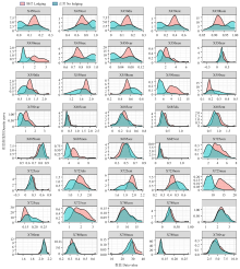
图5
纹理特征密度曲线图"

表3
分类精度统计"
| 特征组合 Feature combination | 支持向量机SVM | 随机森林 RF | ||||||
|---|---|---|---|---|---|---|---|---|
| 准确率 Accuracy (%) | 精准率 Precision (%) | 召回率 Recall (%) | F1 (%) | 准确率 Accuracy (%) | 精准率 Precision (%) | 召回率 Recall (%) | F1 (%) | |
| 光谱特征 Spectral feature | 75.17 | 64.81 | 97.27 | 77.79 | 77.43 | 67.51 | 95.95 | 79.56 |
| 纹理特征 Texture feature | 75.84 | 65.29 | 98.11 | 78.40 | 75.97 | 65.48 | 97.34 | 78.29 |
| 光谱-纹理 Spectrum-Texture | 75.82 | 65.13 | 98.33 | 78.36 | 75.70 | 65.10 | 97.86 | 79.16 |
| 光谱-DSM Spectrum-DSM | 84.83 | 75.69 | 97.31 | 85.15 | 91.48 | 91.59 | 89.11 | 90.33 |
| 纹理-DSM Texture-DSM | 78.58 | 68.03 | 98.33 | 80.42 | 91.43 | 87.74 | 93.97 | 89.78 |
| 光谱-纹理-DSM Spectrum-Texture-DSM | 78.52 | 67.95 | 9835 | 80.37 | 91.46 | 87.18 | 94.84 | 90.85 |
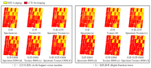
图6
基于支持向量机和随机森林分类下不同特征组合的分类结果对比"

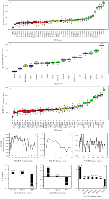
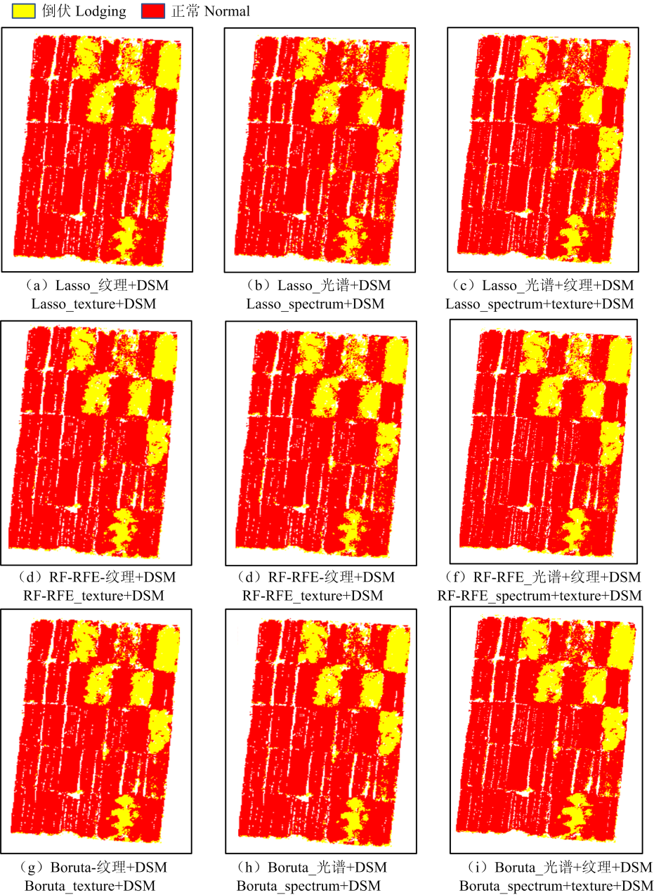
图7
Boruta算法(a)(b)(c)、递归特征消除随机森林特征优化算法(RF-RFE)(d)(e)(f)、套索算法Lasso(g)(h)(i);其中(a)(d)(g)基于纹理-DSM特征组合、(b)(e)(h)基于光谱-DSM特征组合、(c)(f)(i)基于光谱-纹理-DSM特征组合"

表4
特征筛选方法结果的比较"
| 特征子集优化方法 Feature subset optimization method | 纹理-DSM Texture-DSM | 光谱-DSM Spectrum-DSM | 光谱-纹理-DSM Spectrum-Texture-DSM | 平均值 Mean | ||||
|---|---|---|---|---|---|---|---|---|
| Kappa系数 Kappa | 总体精度 OA (%) | Kappa系数 Kappa | 总体精度 OA (%) | Kappa系数 Kappa | 总体精度 OA (%) | Kappa系数 Kappa | 总体精度 OA (%) | |
| 全特征Full-feature | 0.82 | 92.21 | 0.82 | 91.26 | 0.82 | 91.24 | 0.82 | 91.57 |
| Lasso algorithm | 0.75 | 87.54 | 0.77 | 88.80 | 0.83 | 91.54 | 0.78 | 89.29 |
| RF-RFE algorithm | 0.80 | 90.26 | 0.70 | 84.91 | 0.83 | 91.45 | 0.78 | 88.87 |
| Boruta algorithm | 0.82 | 91.15 | 0.82 | 91.26 | 0.86 | 92.82 | 0.83 | 91.74 |
| 平均值 Mean | 0.80 | 90.29 | 0.78 | 89.06 | 0.84 | 91.76 | ||
图8
不同特征选择算法的分类结果"
| [1] |
刘良云, 王纪华, 宋晓宇, 李存军, 黄文江, 赵春江. 小麦倒伏的光谱特征及遥感监测. 遥感学报, 2005(3): 323-327.
|
|
|
|
| [2] |
杨浩, 杨贵军, 顾晓鹤, 李增元, 陈尔学, 冯琦, 杨小冬. 小麦倒伏的雷达极化特征及其遥感监测. 农业工程学报, 2014, 30(7): 1-8.
|
|
|
|
| [3] |
姚金保, 马鸿翔, 姚国才, 杨学明, 周淼平, 张平平, 张鹏. 小麦抗倒性研究进展. 植物遗传资源学报, 2013, 14(2): 208-213.
|
|
|
|
| [4] |
王丹, 丁位华, 冯素伟, 胡铁柱, 李淦, 李笑慧, 杨艳艳, 茹振钢. 不同小麦品种茎秆特性及其与抗倒性的关系. 应用生态学报, 2016, 27(5): 1496-1502.
doi: 10.13287/j.1001-9332.201605.039 |
|
|
|
| [5] |
董荷荷, 骆永丽, 李文倩, 王元元, 张秋霞, 陈金, 金敏, 李勇, 王振林. 不同春季追氮模式对小麦茎秆抗倒性能及木质素积累的影响. 中国农业科学, 2020, 53(21): 4399-4414.
doi: 10.3864/j.issn.0578-1752.2020.21.009 |
|
doi: 10.3864/j.issn.0578-1752.2020.21.009 |
|
| [6] |
陆洲, 徐飞飞, 罗明, 梁爽, 赵晨, 冯险峰. 倒伏水稻特征分析及其多光谱遥感提取方法研究. 中国生态农业学报(中英文), 2021, 29(4): 751-761.
|
|
|
|
| [7] |
陈仲新, 任建强, 唐华俊, 史云, 冷佩, 刘佳, 王利民, 吴文斌, 姚艳敏, 哈斯图亚. 农业遥感研究应用进展与展望. 遥感学报, 2016, 20(5): 748-767.
|
|
|
|
| [8] |
doi: 10.3390/rs9090923 |
| [9] |
doi: 10.3390/rs5105006 |
| [10] |
doi: 10.1016/j.fcr.2017.05.005 |
| [11] |
doi: 10.1016/j.rse.2020.111804 |
| [12] |
胡健波, 张健. 无人机遥感在生态学中的应用进展. 生态学报, 2018, 38(1): 20-30.
|
|
|
|
| [13] |
doi: 10.3390/rs61111051 |
| [14] |
黄艳伟, 朱红雷, 郭宁戈, 殷姝溦, 彭星玥, 王雨蝶. 基于无人机多光谱影像的冬小麦倒伏提取适宜空间分辨率研究. 麦类作物学报, 2021, 41(2): 254-261.
|
|
|
|
| [15] |
doi: 10.1080/10095020.2017.1416994 |
| [16] |
张新乐, 官海翔, 刘焕军, 孟祥添, 杨昊轩, 叶强, 于微, 张汉松. 基于无人机多光谱影像的完熟期玉米倒伏面积提取. 农业工程学报, 2019, 35(19): 98-106.
|
|
|
|
| [17] |
|
| [18] |
赵静, 潘方江, 兰玉彬, 鲁力群, 曹佃龙, 杨东建, 温昱婷. 无人机可见光遥感和特征融合的小麦倒伏面积提取. 农业工程学报, 2021, 37(3): 73-80.
|
|
|
|
| [19] |
王娜, 李强子, 杜鑫, 张源, 赵龙才, 王红岩. 单变量特征选择的苏北地区主要农作物遥感识别. 遥感学报, 2017, 21(4): 519-530.
|
|
|
|
| [20] |
周小成, 郑磊, 黄洪宇. 基于多特征优选的无人机可见光遥感林分类型分类. 林业科学, 2021, 57(6): 24-36.
|
|
|
|
| [21] |
doi: 10.1080/01431161.2021.1942575 |
| [22] |
doi: 10.3390/rs10101528 |
| [23] |
doi: 10.2134/agronj2010.0395 |
| [24] |
|
| [25] |
doi: 10.1078/0176-1617-01176 pmid: 15022830 |
| [26] |
doi: 10.1080/02757259409532252 |
| [27] |
doi: 10.3390/rs12193149 |
| [28] |
李红, 张凯, 陈超, 张志洋, 刘振鹏. 基于高光谱成像技术的生菜冠层含水率检测. 农业机械学报, 2021, 52(2): 211-217, 274.
|
|
|
|
| [29] |
doi: 10.1016/j.eja.2020.126201 |
| [30] |
慕涛阳, 赵伟, 胡晓宇, 李丹. 基于改进的DeepLabV3+模型结合无人机遥感的水稻倒伏识别方法. 中国农业大学学报, 2022, 27(2): 143-154.
|
|
|
|
| [31] |
支俊俊, 董娅, 鲁李灿, 施金辉, 骆文慧, 周悦, 耿涛, 夏敬霞, 贾蔡. 基于无人机RGB影像的玉米种植信息高精度提取方法. 农业工程学报, 2021, 37(18): 48-54.
|
|
|
|
| [32] |
doi: 10.1007/s11356-016-8237-1 |
| [33] |
戴建国, 张国顺, 郭鹏, 曾窕俊, 崔美娜, 薛金利. 基于无人机遥感多光谱影像的棉花倒伏信息提取. 农业工程学报, 2019, 35(2): 63-70.
|
|
|
|
| [34] |
doi: 10.1016/j.inpa.2021.02.003 |
| [35] |
王立志, 顾晓鹤, 胡圣武, 杨贵军, 王磊, 范友波, 王艳杰. 基于多时相HJ-1B CCD影像的玉米倒伏灾情遥感监测. 中国农业科学, 2016, 49(21): 4120-4129.
doi: 10.3864/j.issn.0578-1752.2016.21.006 |
|
|
|
| [36] |
廖鸿燕, 周小成, 黄洪宇. 基于无人机遥感技术的台风灾害倒伏绿化树木检测. 遥感技术与应用, 2021, 36(3): 533-543.
|
|
|
|
| [37] |
doi: 10.3390/agriculture10050146 |
| [38] |
doi: 10.3390/rs11050515 |
| [39] |
doi: 10.3390/rs9060583 |
| [40] |
doi: 10.3390/ijgi10050309 |
| [41] |
|
| [42] |
郭鹏, 武法东, 戴建国, 王海江, 徐丽萍, 张国顺. 基于无人机可见光影像的农田作物分类方法比较. 农业工程学报, 2017, 33(13): 112-119.
|
|
|
|
| [43] |
王恺怡, 杨盛, 郭彩云, 卞希慧. 基于LASSO算法的光谱变量选择方法研究. 分析测试学报, 2022, 41(3): 398-402, 408.
|
|
|
|
| [44] |
赵静, 李志铭, 鲁力群, 贾鹏, 杨焕波, 兰玉彬. 基于无人机多光谱遥感图像的玉米田间杂草识别. 中国农业科学, 2020, 53(8): 1545-1555.
doi: 10.3864/j.issn.0578-1752.2020.08.005 |
|
doi: 10.3864/j.issn.0578-1752.2020.08.005 |
|
| [45] |
熊皓丽, 周小成, 汪小钦, 崔雅君. 基于GEE云平台的福建省10 m分辨率茶园专题空间分布制图. 地球信息科学学报, 2021, 23(7): 1325-1337.
|
|
|
| [1] | 马胜兰, 况福虹, 林洪羽, 崔俊芳, 唐家良, 朱波, 蒲全波. 秸秆还田量对川中丘陵冬小麦-夏玉米轮作体系土壤物理特性的影响[J]. 中国农业科学, 2023, 56(7): 1344-1358. |
| [2] | 常春义, 曹元, Ghulam Mustafa, 刘红艳, 张羽, 汤亮, 刘兵, 朱艳, 姚霞, 曹卫星, 刘蕾蕾. 白粉病对小麦光合特性的影响及病害严重度的定量模拟[J]. 中国农业科学, 2023, 56(6): 1061-1073. |
| [3] | 王箫璇, 张敏, 张鑫尧, 魏鹏, 柴如山, 张朝春, 张亮亮, 罗来超, 郜红建. 不同磷肥对砂姜黑土和红壤磷库转化及冬小麦磷素吸收利用的影响[J]. 中国农业科学, 2023, 56(6): 1113-1126. |
| [4] | 郭燕, 井宇航, 王来刚, 黄竞毅, 贺佳, 冯伟, 郑国清. 基于无人机影像特征的冬小麦植株氮含量预测及模型迁移能力分析[J]. 中国农业科学, 2023, 56(5): 850-865. |
| [5] | 张晓丽, 陶伟, 高国庆, 陈雷, 郭辉, 张华, 唐茂艳, 梁天锋. 直播栽培对双季早稻生育期、抗倒伏能力及产量效益的影响[J]. 中国农业科学, 2023, 56(2): 249-263. |
| [6] | 徐久凯, 袁亮, 温延臣, 张水勤, 李燕婷, 李海燕, 赵秉强. 畜禽有机肥氮在冬小麦季对化肥氮的相对替代当量[J]. 中国农业科学, 2023, 56(2): 300-313. |
| [7] | 蔺江韵, 尹本酥, 王星舒, 刘晨瑞, 孙庆, 解星星, 程玲玲, 孙理维, 石美, 王朝辉. 长期施氮条件下小麦铁锰累积及其与土壤养分的关系[J]. 中国农业科学, 2023, 56(17): 3372-3382. |
| [8] | 牟海萌, 孙丽芳, 王壮壮, 王宇, 宋一凡, 张荣, 段剑钊, 谢迎新, 康国章, 王永华, 郭天财. 施氮量和种植密度对两冬小麦品种抗倒性能和籽粒产量的影响[J]. 中国农业科学, 2023, 56(15): 2863-2879. |
| [9] | 董一帆, 任毅, 程宇坤, 王睿, 张志辉, 时晓磊, 耿洪伟. 冬小麦籽粒主要品质性状的全基因组关联分析[J]. 中国农业科学, 2023, 56(11): 2047-2063. |
| [10] | 吕丽华, 韩江伟, 张经廷, 董志强, 孟建, 贾秀领. 抗逆广适小麦品种共性特征分析[J]. 中国农业科学, 2023, 56(11): 2064-2077. |
| [11] | 王洋洋,刘万代,贺利,任德超,段剑钊,胡新,郭天财,王永华,冯伟. 基于多元统计分析的小麦低温冻害评价及水分效应差异研究[J]. 中国农业科学, 2022, 55(7): 1301-1318. |
| [12] | 冯子恒,宋莉,张少华,井宇航,段剑钊,贺利,尹飞,冯伟. 基于无人机多光谱和热红外影像信息融合的小麦白粉病监测[J]. 中国农业科学, 2022, 55(5): 890-906. |
| [13] | 王淑婷,孔雨光,张赞,陈红艳,刘鹏. 基于星-机光谱融合的棉花叶片SPAD值反演[J]. 中国农业科学, 2022, 55(24): 4823-4839. |
| [14] | 伊英杰,韩坤,赵斌,刘国利,林佃旭,陈国强,任昊,张吉旺,任佰朝,刘鹏. 长期不同施肥措施冬小麦-夏玉米轮作体系周年氨挥发损失的差异[J]. 中国农业科学, 2022, 55(23): 4600-4613. |
| [15] | 马啸,陈鹏飞. 基于无人机多光谱影像的小麦封垄前种植行识别方法改进[J]. 中国农业科学, 2022, 55(20): 3926-3938. |
|
||