


中国农业科学 ›› 2020, Vol. 53 ›› Issue (9): 1773-1794.doi: 10.3864/j.issn.0578-1752.2020.09.007
李方杰,任建强( ),吴尚蓉,陈仲新,张宁丹
收稿日期:2019-08-29
接受日期:2019-11-18
出版日期:2020-05-01
发布日期:2020-05-13
联系方式:
李方杰,E-mail:li_fangjie@126.com。
基金资助:
FangJie LI,JianQiang REN(),ShangRong WU,ZhongXin CHEN,NingDan ZHANG
Received:2019-08-29
Accepted:2019-11-18
Published:2020-05-01
Online:2020-05-13
摘要:
【目的】通过对河南省2001—2015年间不同时期(2001—2005、2006—2010及2011—2015年)冬小麦种植频率(winter wheat planting frequency,WWPF)时空变化及其主要影响因素定量分析,进一步明晰区域作物种植频率变化时空变化分布特征和主要影响因素顺序。【方法】以河南省为研究区,冬小麦为研究作物,在利用中低分辨率MODIS EVI时序遥感数据和CART决策树算法进行连续15年(2001—2015年)作物种植空间分布信息提取基础上,获取了研究区不同时期冬小麦种植频率空间信息。在此基础上,开展不同时期冬小麦种植频率时空变化分析,并利用相关分析、主成分分析和线性回归分析等数理统计方法对不同时期研究区种植频率变化的影响因素进行分析,最终确定主要影响因素的重要性排序。【结果】基于MODIS EVI时序遥感数据和CART决策树算法可获得河南省较高精度连续多年冬小麦种植空间分布信息,经验证,研究区冬小麦遥感提取平均总体精度为90.39%,Kappa系数在0.82—0.92之间,可满足区域冬小麦种植频率变化研究所需作物空间分布精度要求;通过分析河南省不同时期冬小麦种植频率时空变化信息,省域内冬小麦主产区大部分具有较高的冬小麦种植频率(WWPF>80%),而豫西南和豫南等山区由于地形复杂、自然条件较差导致冬小麦种植频率普遍较低(WWPF≤40%)。此外,3个时段期间,河南省冬小麦主产区高频种植冬小麦面积呈逐步增加趋势,WWPF>80%的面积比例分别为42.68%、59.94%和63.07%,低频种植面积呈减小趋势,WWPF≤40%的面积比例分别为28.53%、17.99%和16.63%,这对我国冬小麦主产区稳定粮食种植面积具有重要意义;从冬小麦种植频率影响因素分析结果看,河南省冬小麦种植频率与有效灌溉面积比例、土壤质量综合指数、播期气候适宜度、坡度和高程等指标间均存在显著的相关性,且除与坡度、高程呈负相关外,与其余因素均为正相关关系。以上指标对河南省冬小麦种植频率变化影响程度的排序结果为土壤综合质量指数>播期气候适宜度>有效灌溉面积比例>坡度(高程),即土壤质量>播期气候条件>灌溉条件>地形条件。【结论】通过对河南省冬小麦种植频率时空变化及其影响因素进行定量分析,明确了河南省冬小麦种植频率时空分布特征和变化规律,明晰了河南省区域冬小麦种植频率变化影响因素及其重要性排序,为开展作物种植面积变化分析提供了一定技术方法和思路借鉴,为区域农业土地利用决策模型构建提供一定基础理论支撑。
李方杰,任建强,吴尚蓉,陈仲新,张宁丹. 河南省冬小麦种植频率时空变化及影响因素分析[J]. 中国农业科学, 2020, 53(9): 1773-1794.
FangJie LI,JianQiang REN,ShangRong WU,ZhongXin CHEN,NingDan ZHANG. Spatio-Temporal Variations of Winter Wheat Planting Frequency and Their Analysis of Influencing Factors in Henan Province[J]. Scientia Agricultura Sinica, 2020, 53(9): 1773-1794.
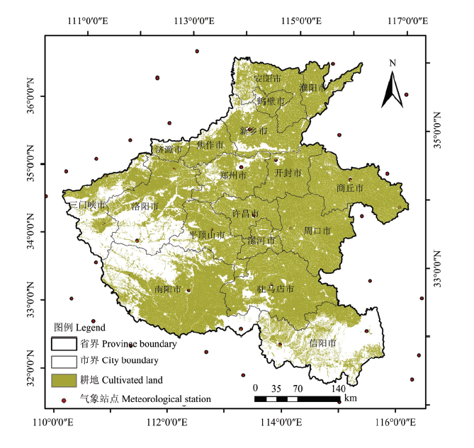
图1
研究区示意图"
表1
河南省冬小麦分布提取样点数量(2001—2015年)"
| 年份 Year | 地面样点 Ground samples | Google Earth样点 Google Earth samples | 训练样点 Training samples | ||||||
|---|---|---|---|---|---|---|---|---|---|
| 冬小麦 Winter wheat | 非冬小麦 Non-winter wheat | 总计 Total | 冬小麦 Winter wheat | 非冬小麦 Non-winter wheat | 总计 Total | 冬小麦 Winter wheat | 非冬小麦 Non-winter wheat | 总计 Total | |
| 2001 | — | — | — | 1145 | 1073 | 2218 | 295 | 423 | 718 |
| 2002 | — | — | — | 1165 | 1118 | 2283 | 315 | 468 | 783 |
| 2003 | — | — | — | 1155 | 1101 | 2256 | 305 | 451 | 756 |
| 2004 | — | — | — | 1095 | 1150 | 2245 | 245 | 500 | 745 |
| 2005 | — | — | — | 1100 | 1117 | 2217 | 250 | 467 | 717 |
| 2006 | 39 | 42 | 81 | 1129 | 1081 | 2210 | 318 | 473 | 791 |
| 2007 | 53 | 54 | 107 | 1027 | 1026 | 2053 | 230 | 430 | 660 |
| 2008 | 44 | 41 | 85 | 1027 | 1024 | 2051 | 221 | 415 | 636 |
| 2009 | 47 | 45 | 92 | 1043 | 1115 | 2158 | 240 | 510 | 750 |
| 2010 | 45 | 45 | 90 | 1015 | 1105 | 2120 | 210 | 500 | 710 |
| 2011 | 51 | 53 | 104 | 1049 | 1022 | 2071 | 250 | 425 | 675 |
| 2012 | 57 | 58 | 115 | 1073 | 1057 | 2130 | 280 | 465 | 745 |
| 2013 | 62 | 60 | 122 | 1023 | 999 | 2022 | 235 | 409 | 644 |
| 2014 | 69 | 71 | 140 | 998 | 1006 | 2004 | 217 | 427 | 644 |
| 2015 | 71 | 70 | 141 | 984 | 995 | 1979 | 205 | 415 | 620 |
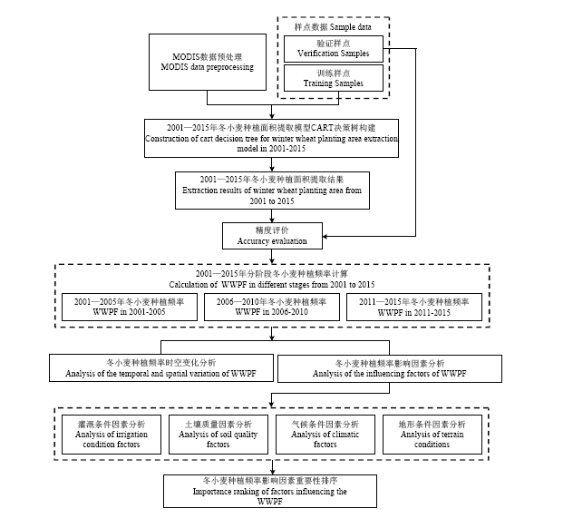
图2
总体技术路线"
表2
冬小麦播种期气候因子适宜度计算主要参数表"
| 指标名称 Indicator name | 输入参数 Input parameter | 计算公式 Computational formulas | 备注 Remarks |
|---|---|---|---|
| 旬温度适宜度 Ten days temperature suitability | 温度适宜度S(T) Temperature suitability S(T) | $S(T)=[(T-T_1)(T_2-T)^B]/[(T_0-T_1)(T_2-T_0)^B]\\B= (T_2-T_0)/(T_0-T_1)$ | T是旬平均温度,T1、T2、T0分别是该时段生长发育下限温度、上限温度和最适温度,分别取值4、33、15[ T is the ten days average temperature, T1, T2, T0 are the lower limit temperature, upper limit temperature and the most suitable temperature for growth and development in this period, taking 4, 33, 15 respectively [ |
| 旬降水适宜度 Ten days precipitation suitability | 降水适宜度S(R) Precipitation suitability S(R) | $S(R)=\begin{cases} R/ R_{0} & R<R_{0} \\ R_{0}/R & R> R_{0} \end{cases}$ | R为旬平均降水量(mm),R0为作物生理需水量,研究中,10月上旬和中旬R0分别11mm和9.1mm[ R is tens day average precipitation (mm), R0 is the physiological water demand of crops, in the first ten days and the middle ten days of October, R0 is 11mm and 9.1mm respectively [ |
| 旬日照适宜度 Ten days sunshine suitability | 日照适宜度S(L) Sunshine suitability S(L) | $S(L)=\begin{cases} e^{-[(L-L_{0})/b]^{2}} & L<L_{0} \\ l & L\geq L_{0} \end{cases}$ | L表示实际日照时数(小时),L0表示日照百分率为70%的日照时数,b为常数,文中L0=7.69,b=4.15[ L represents the actual sunshine hours (hours), L0 is the sunshine hours with the sunshine percentage of 70%, and b is a constant. In this paper, L0 = 7.69, b = 4.15 [ |
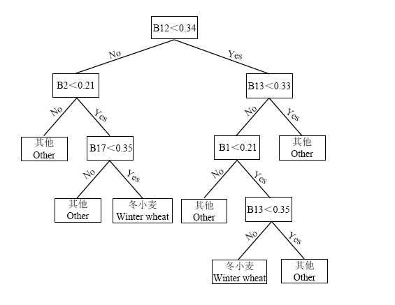
图3
河南省冬小麦分布提取CART决策树(2010年)"
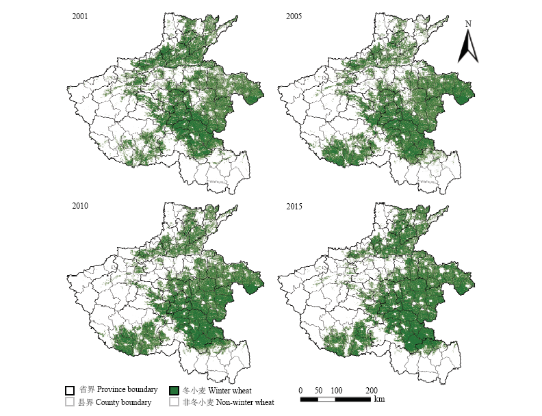
图4
河南省部分年份冬小麦空间分布提取结果"
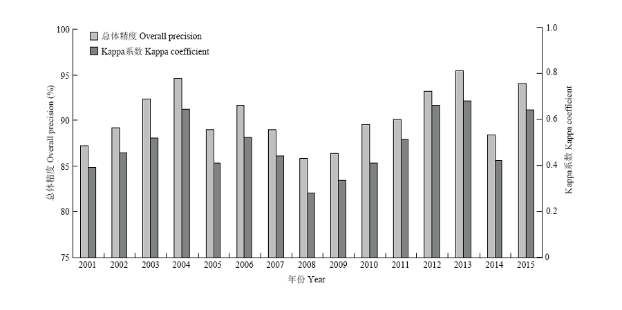
图5
河南省不同年份冬小麦遥感识别精度结果"
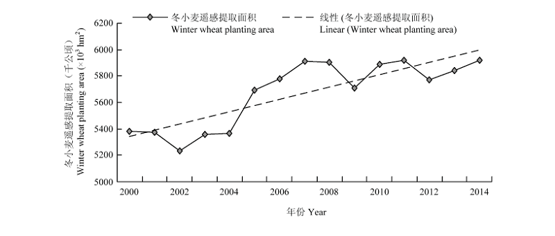
图6
河南省冬小麦遥感提取面积(2001—2015)"
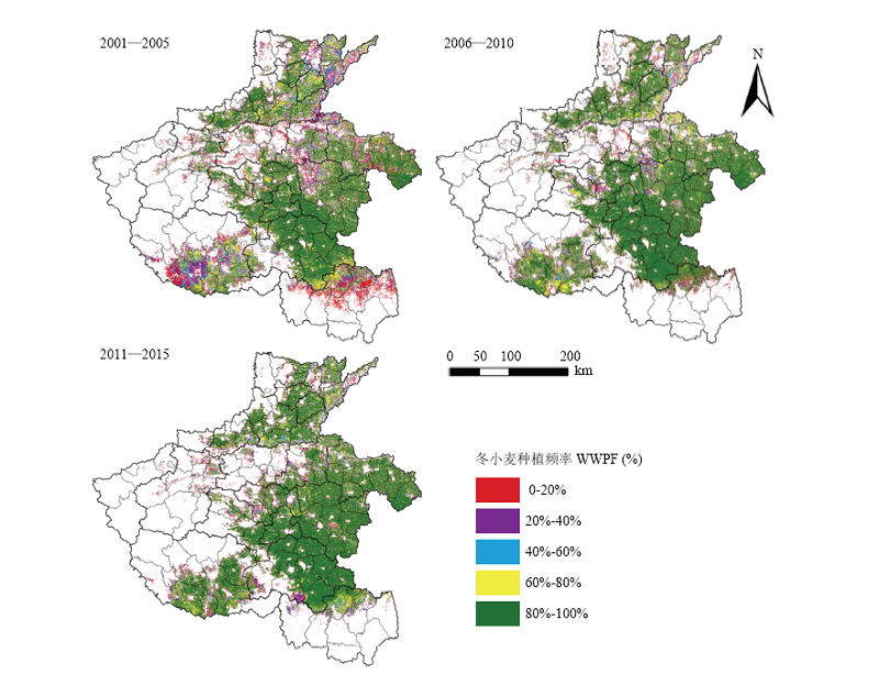
图7
河南省不同时期冬小麦种植频率空间分布图"
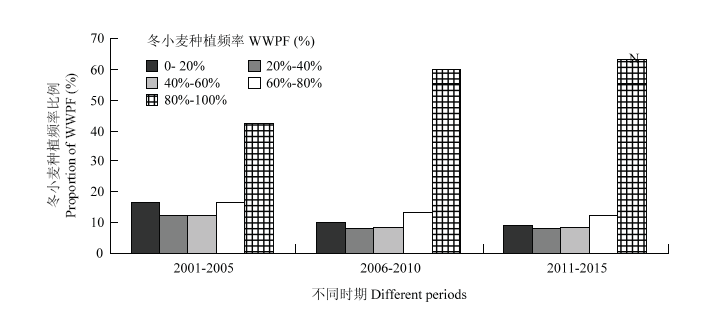
图8
河南省不同时期冬小麦种植频率比例变化情况"
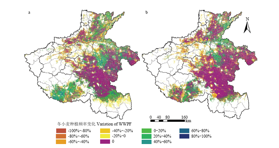
图9
河南省不同时期冬小麦种植频率变化空间分布图 (a)第二阶段与第一阶段间冬小麦种植频率变化;(b)第三阶段与第二阶段间冬小麦种植频率变化"
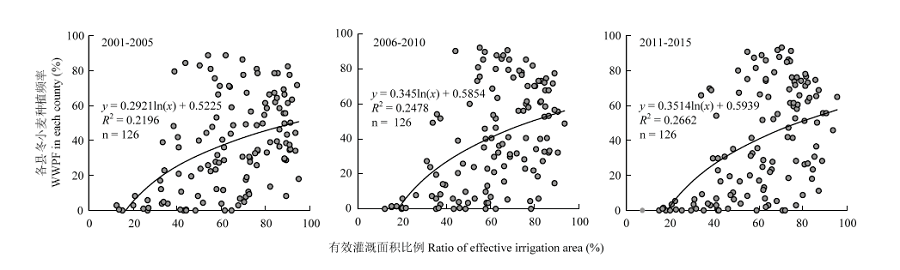
图10
河南省不同时期各县冬小麦种植频率与有效灌溉面积比例间关系"
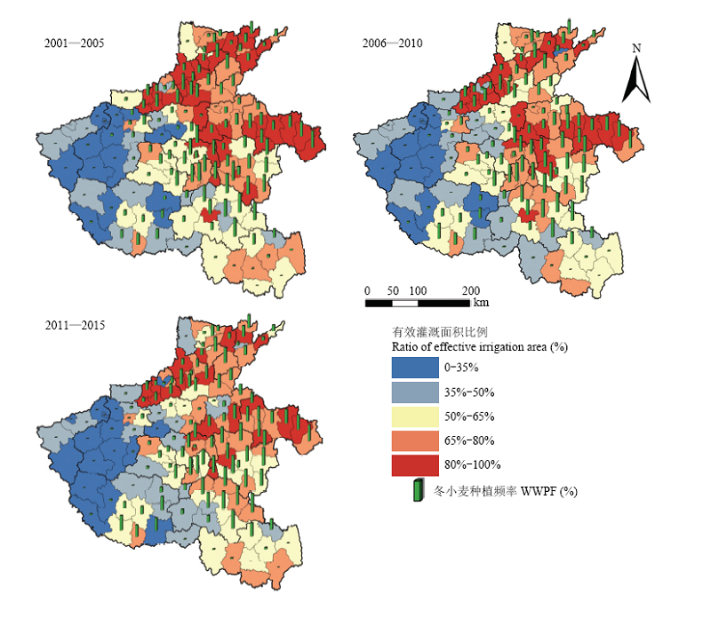
图11
河南省不同时期各县冬小麦种植频率与有效灌溉面积比例空间分布2.3.2 冬小麦种植频率与土壤质量间关系分析"
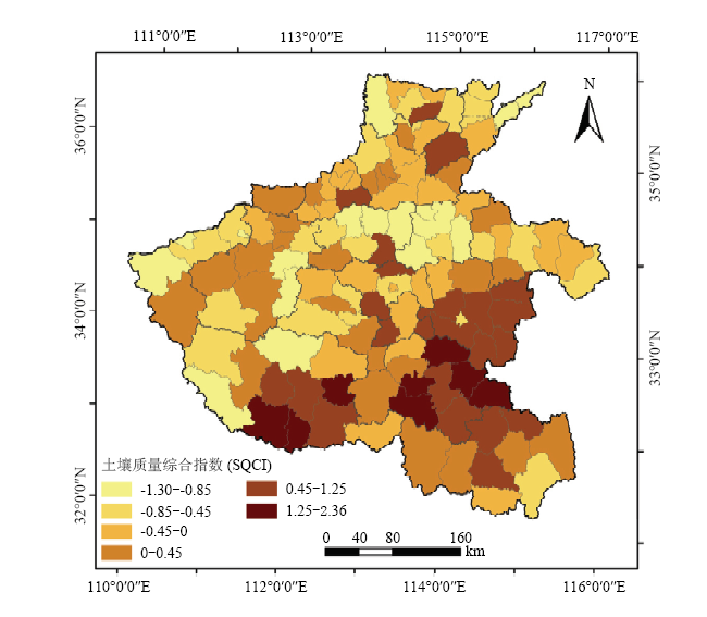
图12
河南省各县土壤质量综合指数空间分布结果"
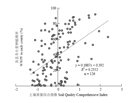
图13
河南省冬小麦种植频率与土壤质量综合指数间关系"

图14
河南省不同时期冬小麦种植频率与播种期气候适宜度空间分布"
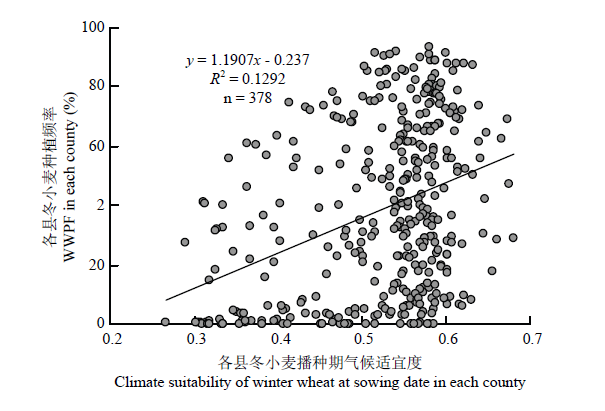
图15
河南省各县冬小麦种植频率与播种期气候适宜度间散点图"
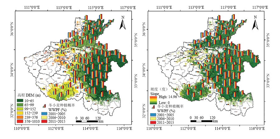
图16
河南省各县冬小麦种植频率与高程和坡度分布图"

图17
河南省各县冬小麦种植频率与高程和坡度间散点图"
| [1] | 吴文斌, 杨鹏, 李正国, 陈仲新, 周清波, 唐华俊 . 农作物空间格局变化研究进展评述. 中国农业资源与区划, 2014,35(1):12-20. |
| WU W B, YANG P, LI Z G, CHEN Z X, ZHOU Q B, TANG H J . Overview of research progresses in crop spatial pattern changes. Chinese Journal of Agricultural Resources and Regional Planning, 2014,35(1):12-20. (in Chinese) | |
| [2] |
胡琼, 吴文斌, 宋茜, 余强毅, 杨鹏, 唐华俊 . 农作物种植结构遥感提取研究进展. 中国农业科学, 2015,48(10) : 1900-1914.
doi: 10.3864/j.issn.0578-1752.2015.10.004 |
|
HU Q, WU W B, SONG Q, YU Q Y, YANG P, TANG H J . Recent progresses in research of crop patterns mapping by using remote sensing. Scientia Agricultura Sinica, 2015,48(10) : 1900-1914. (in Chinese)
doi: 10.3864/j.issn.0578-1752.2015.10.004 |
|
| [3] |
潘学鹏, 李改欣, 刘峰贵, 吴喜芳, 近藤昭彦, 沈彦俊 . 华北平原冬小麦面积遥感提取及时空变化研究. 中国生态农业学报, 2015,23(4):497-505.
pmid: 19431994 |
|
PAN X P, LI G X, LIU F G, WU X F, KONDOH A, SHEN Y J . Using remote sensing to determine spatio-temporal variations in winter wheat growing area in the North China Plain. Chinese Journal of Eco-Agriculture, 2015,23(4):497-505. (in Chinese)
pmid: 19431994 |
|
| [4] | 唐华俊, 吴文斌, 杨鹏, 周清波, 陈仲新 . 农作物空间格局遥感监测研究进展. 中国农业科学, 2010,43(14):2879-2888. |
| TANG H J, WU W B, YANG P, ZHOU Q B, CHEN Z X . Recent progresses in monitoring crop spatial patterns by using remote sensing technologies. Scientia Agricultura Sinica, 2010,43(14):2879-2888. (in Chinese) | |
| [5] | 余强毅, 吴文斌, 陈羊阳, 杨鹏, 孟超英, 周清波, 唐华俊 . 农作物空间格局变化模拟模型的MATLAB实现及应用. 农业工程学报, 2014,30(12):105-114. |
| YU Q Y, WU W B, CHEN Y Y, YANG P, MENG C Y, ZHOU Q B, TANG H J . Model application of an agent-based model for simulating crop pattern dynamics at regional scale based on MATLAB. Transactions of the Chinese Society of Agricultural Engineering, 2014,30(12):105-114. (in Chinese) | |
| [6] |
LIU Z H, YANG P, WU W B, YOU L Z . Spatiotemporal changes of cropping structure in China during 1980-2011. Journal of Geographical Sciences, 2018,28(11):1659-1671.
doi: 10.1007/s11442-018-1535-4 |
| [7] | 宋桂琴, 徐惠民, 刘志晨 . 辽宁省农作物种植结构时空变化特征分析. 中国农学通报, 2019,35(5):24-31. |
| SONG G Q, XU H M, LIU Z C . Temporal and spatial characteristics of crop planting structure in Liaoning province. Chinese Agricultural Science Bulletin, 2019,35(5):24-31. (in Chinese) | |
| [8] | 王红营 . 基于遥感的华北平原农业土地利用时空变化特征及驱动力分析[D]. 石家庄: 河北师范大学, 2016. |
| WANG H Y . Using remote sensing to analyze spatiotemporal variations in farmland utilization and driving force in the North China Plain[D]. Shijiazhuang: Hebei Normal University, 2016. (in Chinese) | |
| [9] | XIAO X, BOLES S, FROLKING S, LI C, BABU J, SALAS W, MOORE B . Mapping paddy rice agriculture in South and Southeast Asia using multi-temporal MODIS images. Remote Sensing of Environment, 2006,100(1):95-113. |
| [10] | 陈仲新, 任建强, 唐华俊, 史云, 冷佩, 刘佳, 王利民, 吴文斌, 姚艳敏, 哈斯图亚 . 农业遥感研究应用进展与展望. 遥感学报, 2016,20(5):748-767. |
| CHEN Z X, REN J Q, TANG H J, SHI Y, LENG P, LIU J, WANG L M, WU W B, YAO Y M, HASI T Y . Progress and perspectives on agricultural remote sensing research and applications in China. Journal of Remote Sensing, 2016,20(5):748-767. (in Chinese) | |
| [11] |
杨珺雯, 张锦水, 潘耀忠, 孙佩军, 朱爽 . 基于遥感识别误差校正面积的农作物种植面积抽样高效分层指标研究—以冬小麦为例. 中国农业科学, 2018,51(4):675-687.
doi: 10.3864/j.issn.0578-1752.2018.04.007 |
|
YANG J W, ZHANG J S, PAN Y Z, SUN P J, ZHU S . An efficient hierarchical indicator based on the correction area of remote sensing identification error for planting acreage sampling-A case study of winter wheat. Scientia Agricultura Sinica, 2018,51(4):675-687. (in Chinese)
doi: 10.3864/j.issn.0578-1752.2018.04.007 |
|
| [12] |
CHANG J, HANSEN M, PITTMAN K, CARROLL M, DIMICELI C . Corn and soybean mapping in the United States using MODIS time-series data sets. Agronomy Journal. 2007,99(6):1654-1664.
doi: 10.1016/j.fertnstert.2013.01.092 pmid: 23394781 |
| [13] | 张莎, 张佳华, 白雲, 姚凤梅 . 基于MODIS-EVI及物候差异免阈值提取黄淮海平原冬小麦面积. 农业工程学报, 2018,34(11):150-158. |
| ZHANG S, ZHANG J H, BAI Y, YAO F M . Extracting winter wheat area in Huanghuaihai Plain using MODIS-EVI data and phenology difference avoiding threshold. Transactions of the Chinese Society of Agricultural Engineering, 2018,34(11):150-158. (in Chinese) | |
| [14] | 黄青, 唐华俊, 吴文斌, 李丹丹, 刘佳 . 农作物分布格局动态变化的遥感监测—以东北三省为例. 中国农业科学, 2013,46(13):2668-2676. |
| HUANG Q, TANG H J, WU W B, LI D D, LIU J . Remote sensing based dynamic changes analysis of crop distribution pattern-Taking Northeast China as an example. Scientia Agricultura Sinica, 2013,46(13):2668-2676. (in Chinese) | |
| [15] | 权文婷, 王钊 . 冬小麦种植面积遥感提取方法研究. 国土资源遥感, 2013,25(4):8-15. |
| QUAN W T, WANG Z . Researches on the extraction of winter wheat planting area using remote sensing method. Remote Sensing for Land and Resources, 2013,25(4):8-15. (in Chinese) | |
| [16] | 许文波, 田亦陈 . 作物种植面积遥感提取方法的研究进展. 云南农业大学学报, 2005,20(1):94-98. |
| XU W B, TIAN Y C . Overview of extraction of crop area from remote sensing. Journal of Yunnan Agricultural University, 2005,20(1):94-98. (in Chinese) | |
| [17] | 李石华, 王金亮, 毕艳, 陈姚, 朱妙园, 杨帅, 朱佳 . 遥感图像分类方法研究综述. 国土资源遥感, 2005,17(2):1-6. |
| LI S H, WANG J L, BI Y, CHEN Y, ZHU M Y, YANG S, ZHU J . A review of methods for classification of remote sensing images. Remote Sensing for Land & Resources, 2005,17(2):1-6. (in Chinese) | |
| [18] | 刘勇洪, 牛铮, 王长耀 . 基于MODIS数据的决策树分类方法研究与应用. 遥感学报, 2005,9(4):405-412. |
| LIU Y H, NIU Z, WANG C Y . Research and application of the decision tree classification using MODIS data. Journal of Remote Sensing, 2005,9(4):405-412. (in Chinese) | |
| [19] |
CHEN L, SUN Y . Comparison of object-oriented remote sensing image classification based on different decision trees in forest area. Chinese Journal of Applied Ecology, 2018,29(12):3995-4003.
doi: 10.13287/j.1001-9332.201812.015 pmid: 30584726 |
| [20] | 刘焕军, 于胜男, 张新乐, 郭栋, 殷继先 . 一年一季农作物遥感分类的时效性分析. 中国农业科学, 2017,50(5):830-839. |
| LIU H J, YU S N, ZHANG X L, GUO D, YIN J X . Timeliness analysis of crop remote sensing classification one crop a year. Scientia Agricultura Sinica, 2017,50(5):830-839. (in Chinese) | |
| [21] | 张晓娟, 杨英健, 盖利亚, 李亮, 王宇 . 基于CART决策树与最大似然比法的植被分类方法研究. 遥感信息, 2010(2):88-92. |
| ZHANG X J, YANG Y J, GAI L Y, LI L, WANG Y . Research on vegetation classification method based on combined decision tree algorithm and maximum likelihood ratio. Remote Sensing Information, 2010(2):88-92. (in Chinese) | |
| [22] | 黄健熙, 贾世灵, 武洪峰, 苏伟 . 基于GF-1 WFV影像的作物面积提取方法研究. 农业机械学报, 2015,46(S1):253-259. |
| HUANG J X, JIA S L, WU H F, SU W . Extraction method of crop planted area based on GF-1 WFV image. Transactions of the Chinese Society for Agricultural Machinery, 2015,46(S1):253-259. (in Chinese) | |
| [23] | 米晓楠, 杨超, 李峰, 相栋, 李孟蔚, 赵永强, 闫加海 . 晋南区冬小麦种植分布卫星遥感反演及时空变化分析. 山西农业科学, 2018,46(3):378-382. |
| MI X N, YANG C, LI F, XIANG D, LI M W, ZHAO Y Q, YAN J H . Analysis of temporal and spatial variations in winter wheat growing regions in Jinnan region using remote sensing. Journal of Shanxi Agricultural Sciences, 2018,46(3):378-382. (in Chinese) | |
| [24] |
XIANG M T, YU Q Y, WU W B . From multiple cropping index to multiple cropping frequency: Observing cropland use intensity at a finer scale. Ecological Indicators, 2019,101:892-903.
doi: 10.1016/j.ecolind.2019.01.081 |
| [25] | BORYAN C, YANG Z, WILLIS P, DI L . Developing crop specific area frame stratifications based on geospatial crop frequency and cultivation data layers. Journal of Integrative Agriculture, 2017,16(2):312-323. |
| [26] | 边金虎, 李爱农, 宋孟强, 马利群, 蒋锦刚 . MODIS植被指数时间序列Savitzky-Golay滤波算法重构. 遥感学报, 2010,14(4):725-741. |
| BIAN J H, LI A N, SONG M Q, MA L Q, JIANG J G . Reconstruction of NDVI time-series datasets of MODIS based on Savitzky-Golay filter. Journal of Remote Sensing, 2010,14(4):725-741. (in Chinese) | |
| [27] | SHI X, YU D, XU S, WARNER E, WANG H, SUN W, ZHAO Y, GONG Z . Cross-reference for relating genetic soil classification of China with WRB at different scales. Geoderma, 2010,155(1):344-350. |
| [28] |
SHI X, YU D, WARNER E, PAN X, PETERSEN G, GONG Z, WEINDORF D . Soil database of 1:1,000,000 digital soil survey and reference system of the Chinese genetic soil classification system. Soil Horizons, 2004,45(4):129.
doi: 10.2136/sh2004.4.0129 |
| [29] | 王学, 李秀彬, 谈明洪, 辛良杰 . 华北平原2001-2011年冬小麦播种面积变化遥感监测. 农业工程学报, 2015,31(8):190-199. |
| WANG X, LI X B, TAN M H, XIN L J . Remote sensing monitoring of changes in winter wheat area in North China Plain from 2001 to 2011. Transactions of the Chinese Society of Agricultural Engineering, 2015,31(8):190-199. (in Chinese) | |
| [30] | ZHANG N, WU Y, ZHANG Q . Detection of sea ice in sediment laden water using MODIS in the Bohai Sea: a CART decision tree method. International Journal of Remote Sensing, 2015,36(6):1661-1674. |
| [31] |
RUFIN P, LEVERS C, BAUMANN M, JAGERMEYR J, KRUEGER T, KUEMMERLE T, HOSTERT P . Global-scale patterns and determinants of cropping frequency in irrigation dam command areas. Global Environmental Change, 2018,50:110-122.
doi: 10.1016/j.gloenvcha.2018.02.011 |
| [32] |
WILKEN F, WAGNER P, NARASIMHAN B, FIENER P . Spatio-temporal patterns of land use and cropping frequency in a tropical catchment of South India. Applied Geography, 2017,89:124-132.
doi: 10.1016/j.apgeog.2017.10.011 |
| [33] | 范玲玲 . 过去65年中国小麦种植时空格局变化及其驱动因素分析[D]. 北京: 中国农业科学院, 2018. |
| FAN L L . Spatio-temporal variation of wheat cultivation in China and its driving factors during the past 65 years[D]. Beijing: Chinese Academy of Agricultural Sciences, 2018. (in Chinese) | |
| [34] | 裴源生, 李旭东, 杨明智 . 21世纪以来我国灌溉面积构成及农业种植结构变化趋势. 灌溉排水学报, 2018,37(4):1-8. |
| PEI Y S, LI X D, YANG M Z . Changes in irrigated areas and the types of cropland in China since 2000. Journal of Irrigation and Drainage, 2018,37(4):1-8. (in Chinese) | |
| [35] | 刘占锋, 傅伯杰, 刘国华, 朱永官 . 土壤质量与土壤质量指标及其评价. 生态学报, 2006,26(3):901-913. |
| LIU Z F, FU B J, LIU G H, ZHU Y G . Soil quality: Concept, indicators and its assessment. Acta Ecologica Sinica, 2006,26(3):901-913. (in Chinese) | |
| [36] | 张心昱, 陈利顶 . 土壤质量评价指标体系与评价方法研究进展与展望. 水土保持研究, 2006,13(3):30-34. |
| ZHANG X Y, CHEN L D . The progress and prospect of soil quality indicators and evaluation methods. Research of Soil and Water Conservation, 2006,13(3):30-34. (in Chinese) | |
| [37] | 刘广明, 吕真真, 杨劲松, 李可晔, 余世鹏 . 基于主成分分析及GIS的环渤海区域土壤质量评价. 排灌机械工程学报, 2015,33(1):67-72. |
| LIU G M, LÜ Z Z, YANG J S, LI K Y, YU S P . Quality evaluation of soil in land along Bohai Sea Coast by principal component analysis and GIS. Journal of Drainage and Irrigation Machinery Engineering, 2015,33(1):67-72. (in Chinese) | |
| [38] | 马树庆 . 吉林省农业气候研究. 吉林: 气象出版社, 1996. |
| MA S Q. Agroclimatic Studie in Jilin Province. Jilin: China Meteorological Press, 1996. (in Chinese) | |
| [39] | 蒋定生, 黄国俊, 帅启富, 刘梅 . 渭北旱塬降水对农作物生长适宜度的模糊分析. 水土保持研究, 1992(2):61-71. |
| JIANG D S, HUANG G J, SHUAI Q F, LIU M . Fuzzy analysis the suitable degrees of the precipitation to the agro-crops growing in the arid Plain of Northern Wei River. Research of Soil and Water Conservation, 1992(2):61-71. (in Chinese) | |
| [40] |
黄璜 . 中国红黄壤地区作物生产的气候生态适应性研究. 自然资源学报, 1996,11(4):340-346.
doi: 10.11849/zrzyxb.1996.04.007 |
|
HUANG H . A study on the climatic ecology adaptability of the crop production in the Red and Yellow Soils Region of China. Journal of Natural Resources, 1996,11(4):340-346. (in Chinese)
doi: 10.11849/zrzyxb.1996.04.007 |
|
| [41] | 千怀遂, 焦士兴, 赵峰 . 河南省冬小麦气候适宜性变化研究. 生态学杂志, 2005,24(5):503-507. |
| QIAN H S, JIAO S X, ZHAO F . Climate suitability change of winter wheat in Henan province. Chinese Journal of Ecology, 2005,24(5):503-507. (in Chinese) | |
| [42] | 赵峰 . 河南省冬小麦气候适宜性变化研究[D]. 开封: 河南大学, 2002. |
| ZHAO F . Research on the climate suitability change of winter wheat in Henan province[D]. Kaifeng: Henan University, 2002. (in Chinese) | |
| [43] | 李伟毅, 赵佳 . 中国农业直接补贴: 演变历程、阶段特征与变迁方向. 经济研究参考, 2012(60):5-12. |
| LI W Y, ZHAO J . China’s agricultural direct subsidy: Evolution process, stage characteristics and change direction. Review of Economic Research, 2012(60):5-12. (in Chinese) | |
| [44] | 中华人民共和国农业部. 中国农业统计资料. 2010. 北京: 中国农业出版社, 2011. |
| Ministry of Agriculture of the People’s Republic of China. China Agriculture Statistical Report.2010. Beijing: China Agriculture Press, 2011. | |
| [45] | 中华人民共和国农业部. 中国农业统计资料. 2013. 北京: 中国农业出版社, 2014. |
| Ministry of Agriculture of the People’s Republic of China. China Agriculture Statistical Report. 2013. Beijing: China Agriculture Press, 2014. | |
| [46] | 高惠璇 . 应用多元统计分析. 北京: 北京大学出版社, 2005. |
| GAO H X. Application of Multivariate Statistical Analysis. Beijing: Peking University Press, 2005. (in Chinese) | |
| [47] | 黄勇, 杨忠芳 . 土壤质量评价国外研究进展. 地质通报, 2009,28(1):130-136. |
| HUANG Y, YANG Z F . Recent research progress of overseas soil quality evaluation. Geological Bulletin of China, 2009,28(1):130-136. (in Chinese) |
| [1] | 朱琦, 贾振鹏, Tahir SHAH, 徐晨晟, 李芷琦, 吕会帅, 朱鹏超, 韦小敏, 黄冬琳, 孙艳妮, 曹卫东, 高亚军, 王朝辉, 张达斌. 绿肥配施增效产品降低旱地麦田温室气体排放及碳足迹[J]. 中国农业科学, 2026, 59(7): 1507-1522. |
| [2] | 钱瑾, 李映雪, 吴芳, 邹晓晨. 集成光谱降维的冬小麦叶片磷含量估算[J]. 中国农业科学, 2026, 59(4): 781-792. |
| [3] | 孔媛, 崔沙沙, 李美, 李健, 杨思雨, 房锋, 刘帅帅, 刘明平, 曾艳, 高兴祥, 柏连阳. 黄淮海冬小麦田多花黑麦草等5种禾本科杂草时空分布变化规律[J]. 中国农业科学, 2026, 59(4): 807-823. |
| [4] | 咸青林, 肖鉴珂, 高阿庆, 郜利闯, 刘杨. 种植方式结合测墒补灌下冬小麦产量及水分利用效率[J]. 中国农业科学, 2026, 59(3): 589-601. |
| [5] | 王佳美, 徐奉奇, 周慧, 胡向东. 我国农业社会化服务发展现状、地区性特征及国际经验镜鉴[J]. 中国农业科学, 2026, 59(2): 459-474. |
| [6] | 吕旭东, 孙世媛, 李亚楠, 刘玉龙, 王艳群, 付鑫, 张佳英, 宁鹏, 彭正萍. 智能机械化分层施肥对麦田根-土养分分布和小麦产量的影响[J]. 中国农业科学, 2026, 59(1): 129-146. |
| [7] | 蒲丽霞, 张佳芮, 叶建萍, 黄秀兰, 樊高琼, 杨洪坤. 二氢赤霉素与秸秆覆盖对旱地小麦分蘖成穗与产量的影响[J]. 中国农业科学, 2025, 58(9): 1735-1748. |
| [8] | 史帆, 李文广, 易树生, 杨娜, 陈玉萌, 郑伟, 张雪辰, 李紫燕, 翟丙年. 有机无机肥配施下旱地麦田土壤有机碳组分含量的变化特征[J]. 中国农业科学, 2025, 58(4): 719-732. |
| [9] | 房康睿, 丁世杰, 陈雨珊, 杨秉庚, 郭腾飞, 徐新朋, 赵士诚, 王秀斌, 黄绍敏, 仇少君, 何萍, 周卫. 有机无机肥配施下典型潮土小麦季有机肥氮磷的当季释放率[J]. 中国农业科学, 2025, 58(24): 5234-5246. |
| [10] | 佘映军, 周子哲, 伍明, 郭魏, 师昌健, 胡超, 李平. 地下水埋深和施氮对土壤水盐分布及冬小麦养分吸收利用的影响[J]. 中国农业科学, 2025, 58(20): 4285-4304. |
| [11] | 李艾雯, 成金礼, 陈丹, 陈鑫怡, 毛雅若, 李启权. 基于数据填补的四川盆地耕地表层土壤无机碳时空变化特征[J]. 中国农业科学, 2025, 58(14): 2838-2853. |
| [12] | 王荣荣, 徐宁璐, 黄修利, 赵凯男, 黄明, 王贺正, 付国占, 吴金芝, 李友军. 一次灌溉和氮肥运筹对旱地小麦籽粒产量和品质的影响[J]. 中国农业科学, 2025, 58(1): 43-57. |
| [13] | 高兴祥, 孔媛, 张耀中, 李美, 李健, 金岩, 张国福, 刘帅帅, 刘明平, 曾艳, 柏连阳. 河南省冬小麦田杂草群落分布现状及其变化原因分析[J]. 中国农业科学, 2025, 58(1): 91-100. |
| [14] | 吕金岭, 尤克, 王小非, 肖强, 李文峰, 马进, 杨清, 张金平, 孔海江, 常运华. 河南省典型农区近地表大气氨时空分布特征及主要影响因素[J]. 中国农业科学, 2025, 58(1): 127-140. |
| [15] | 臧少龙, 刘淋茹, 高越之, 吴珂, 贺利, 段剑钊, 宋晓, 冯伟. 基于无人机影像多时相的小麦品种氮效率分类识别[J]. 中国农业科学, 2024, 57(9): 1687-1708. |
|
||