


中国农业科学 ›› 2019, Vol. 52 ›› Issue (3): 445-454.doi: 10.3864/j.issn.0578-1752.2019.03.005
李超1,李文峰2( ),赵耀2,尚敬敏2
收稿日期:2018-09-11
接受日期:2018-12-17
出版日期:2019-02-01
发布日期:2019-02-14
通讯作者:
李文峰
作者简介:李超,E-mail: 基金资助:
LI Chao1,LI WenFeng2(),ZHAO Yao2,SHANG JingMin2
Received:2018-09-11
Accepted:2018-12-17
Online:2019-02-01
Published:2019-02-14
摘要:
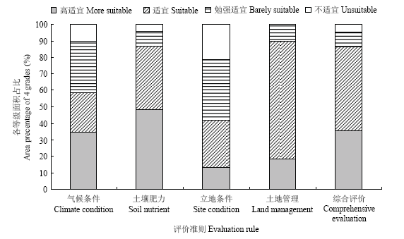
目的 作物适宜性评价是进行生产区划的重要手段,本研究拟基于气象、土壤、地形数据,构建适宜山地环境的玉米生态适宜性评价模型和方法。方法 在文献系统分析的基础上,遴选18个生态指标构成玉米生态适宜性评价指标体系,气候适宜性评价模型采用作物模型法构建,考虑了玉米生育期和生态效应,其他指标采用隶属度函数法分数值型和概念型分别构建。各因子权重采用专家打分和层次分析法确定,综合权重和适宜性函数构建玉米气候、土壤养分、立地条件、土地管理适宜性评价模型及综合生态适宜性评价模型。评价的数据通过空间分析获得。针对山区耕地的立体分布特点,运用ArcGIS工具综合耕地利用、土壤类型、行政区划划分评价单元,经GIS的插值处理、统计分析,获得各评价单元18个评价指标基础数据,进而运用评价模型对各评价单元进行分类评价和综合生态适宜性评价结果 该方法应用于云南省寻甸县,全县耕地共划分为8 415个评价单元,其气候、土壤养分、立地条件、土地管理4个方面适宜以上的面积分别占比58%、86%、42%、90%。生态适宜性综合评价中,高度适宜区和适宜区的面积占比分别为35.4%、50.6%,主要分布在中-东南部低中山丘陵区,中北部金沙江河谷,西部河谷槽区也有小范围的分布;勉强适宜区、不适宜区面积占9.4%和4.6%,主要零星分布在中部以西地区,而在西北部相对集中。结论 评价方法考虑了玉米生育期和山区耕地立体分布特点,研究区适宜性区划呈碎片状分布,分布情况与区域生产情况基本相符,气候和立地条件是影响研究区玉米生态适宜性的主要因素。
李超, 李文峰, 赵耀, 尚敬敏. 基于GIS的云南山区玉米生态适宜性评价方法与应用[J]. 中国农业科学, 2019, 52(3): 445-454.
LI Chao, LI WenFeng, ZHAO Yao, SHANG JingMin. A Method of Ecological Suitability Evaluation and Its Application for Maize Planted in Mountain Farmland Based on GIS (Case Study: Xundian County)[J]. Scientia Agricultura Sinica, 2019, 52(3): 445-454.
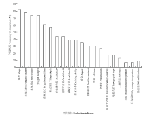
图1
玉米生态适宜性评价的常用指标及入选频度"

表1
玉米生态适宜性评价指标体系及权重"
| 目标层 Target layer | 准则层 Rule layer | 权重 Weight | 指标层 Index layer | 权重 Weight |
|---|---|---|---|---|
| 生态适宜性评价指标Evaluation index system of ecological suitability | 气候条件 Climate condition, U1 | 0.451 | 日平均气温Daily average temperature, U11 (℃) | 0.069 |
| ≥10℃积温≥10℃ accumulated temperature, U12 (℃) | 0.188 | |||
| 降水量Precipitation, U13 (mm) | 0.116 | |||
| 日照时数Sunshine hours, U14 (h) | 0.082 | |||
| 土壤肥力Soil nutrient, U2 | 0.146 | 有机质Organic matter, U21 (g·kg-1) | 0.057 | |
| 有效磷Available P, U22 (mg·kg-1) | 0.024 | |||
| 速效钾Available K, U23 (mg·kg-1) | 0.025 | |||
| 碱解氮 Available N, U24 (mg·kg-1) | 0.017 | |||
| 立地条件Site condition, U3 | 0.168 | pH, U31 | 0.035 | |
| 土壤质地Soil texture, U32 | 0.017 | |||
| 坡度Slope, U33 (°) | 0.014 | |||
| 坡向Aspect, U34 | 0.008 | |||
| 海拔Altitude, U35 (m) | 0.043 | |||
| 地貌类型Topographic type, U36 | 0.017 | |||
| 耕层厚度Tillage depth, U37 (cm) | 0.034 | |||
| 成土母质Parent material, U38 | 0.016 | |||
| 土地管理 Land management, U4 | 0.235 | 灌溉能力Irrigation, U41 | 0.113 | |
| 排涝能力Drainage, U42 (t·km-2) | 0.125 |
表2
数值型评价指标隶属度函数"
| 评价指标 Evaluation index | 函数类型 Function type | 隶属函数 Membership function | 标准值 Standard value | 极限值 Limit value |
|---|---|---|---|---|
| 有机质Organic matter | 戒上型Upper limit | Y=1/[1+0.006889×(ui–c)2][ | 30 | 10 |
| 有效磷Available P | 戒上型Upper limit | Y=1/[1+0.00653×(ui–c)2][ | 40 | 3 |
| 速效钾Available K | 戒上型Upper limit | Y=1/[1+0.000064×(ui–c)2][ | 200 | 30 |
| 碱解氮Available N | 戒上型Upper limit | Y=1/[1+0.001335×(ui–c)2][ | 150 | 30 |
| 耕层厚度Tillage depth | 戒上型Upper limit | Y=1/[1+0.00745×(ui–c)2][ | 40 | 22 |
| 坡度Slope | 戒下型Lower limit | Y=1/[1+0.00496×(ui–c)2][ | 2.84 | 15 |
| pH | 峰值型Peaker | Y=1/[1+0.265×(ui–c)2] [ | 5.74 | 4.5/8.5 |
表3
概念型评价指标隶属度"
| 评价指标 Evaluation index | 描述 Description | 专家评估值 Expert evaluation value | ||||
|---|---|---|---|---|---|---|
| 排涝能力 Irrigation | 指标Index | 优Excellent | 良Good | 中Fair | 较差Worse | 差Poor |
| 隶属度Membership | 1.0 | 0.8 | 0.6 | 0.4 | 0.2 | |
| 灌溉保证率 Drainage | 指标Index | 80-95 | 65-80 | 50-65 | 30-50 | |
| 隶属度Membership | 1.0 | 0.9 | 0.7 | 0.5 | ||
| 成土母质 Parent material | 指标Index | 5, 6, 8 | 9 | 7 | 3, 4 | 1, 2 |
| 隶属度Membership | 1 | 0.8 | 0.7 | 0.5 | 0.4 | |
| 坡向 Aspect | 指标Index | 南 North | 东南、东 Southeast, East | 西南 Southwest | 西 West | 北、东北、西北 North,Northeast,Northwest |
| 隶属度Membership | 1 | 0.8 | 0.7 | 0.6 | 0.4 | |
| 土壤质地 Soil texture | 指标Index | 中壤 Medium loam soil | 轻壤 Light soil | 黏壤 Clay loam soil | 砂壤 Sandy loam soil | |
| 隶属度Membership | 1.0 | 0.9 | 0.8 | 0.7 | ||
| 地貌类型 Topographic type | 指标Index | 1-3 | 4 | 5-6 | 7-10 | 11-16 |
| 隶属度Membership | 1.0 | 0.9 | 0.8 | 0.7 | 0.6 | |
| 海拔 Altitude | 指标Index | ≤1900 | 1900-2200 | 2200-2600 | 2600-3100 | ≥3100 |
| 隶属度Membership | 1 | 0.9 | 0.8 | 0.7 | 0.5 | |
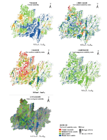
图2
寻甸县玉米种植生态适宜性分析图"
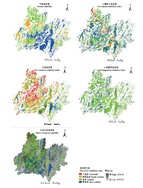
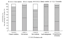
图3
寻甸县玉米生态适宜性评价各等级面积占比情况"
| [1] | 蒋好忱, 雷宝佳, 郭忆 . 自然立地条件下云南省普洱茶种植适宜性分析. 热带农业科学, 2013,33(10):19-23. |
| JIANG H C, LEI B J, GUO Y . Suitability analysis of planting puer tea in Yunnan province based on natural conditions. Chinese Journal of Tropical Agriculture, 2013,33(10):19-23. (in Chinese) | |
| [2] | 郭祥, 范建容, 朱万泽, 严冬 . 基于GIS的四川省油橄榄生态适宜性模糊综合评价. 生态学杂志, 2010,29(3):586-591. |
| GUO X, FAN J R, ZHU W Z, YAN D . Ecological suitability of olive in Sichuan province fuzzy comprehensive evaluation based on GIS. Chinese Joumal of Ecology, 2010,29(3):586-591. (in Chinese) | |
| [3] | 游娟, 潘瑜春, 陈柏松, 王纪华, 陆洲, 张吴明 . 基于GIS的绿色农产品基地适宜性评价. 农业工程学报, 2010, 26(10):325-330+391. |
| YOU J, PAN Y C, CHEN B S, WANG J H, LU Z , ZHANG W M . GIS-based suitability evaluation for green agricultural product base. Transactions of the Chinese Society of Agricultural Engineering, 2010,26(10): 325-330+391. (in Chinese) | |
| [4] | 李文峰, 李超, 杨林楠, 李明, 刘晓林 . 基于WebGIS的食用农产品产地环境质量评价系统. 农业工程学报, 2011,27(6):198-202. |
| LI W F, LI C, YANG L N, LI M, LIU X L . Farmland environmental quality evaluation system for edible agricultural products based on WebGIS. Transactions of the Chinese Society of Agricultural Engineering, 2011,27(6):198-202. (in Chinese) | |
| [5] |
MOHAMED A E A, NATARAJAN A, RAJENDRA H . Assessment of land suitability and capability by integrating remote sensing and GIS for agriculture in Chamarajanagar district, Karnataka, India. The Egyptian Journal of Remote Sensing and Space Sciences, 2016,19:125-141.
doi: 10.1016/j.ejrs.2016.02.001 |
| [6] | JAYASINGHE P K S, MACHIDA T . Web-based GIS online consulting system with crop land suitability identification. Agriculture Information Research, 2008,17:13-19. |
| [7] |
RANYA E , ABDUL R B M S, FAZEL A, NOORDIN B A, SIVA K B, MOHA A M S. Agriculture Land Suitability Evaluator (ALSE): A decision and planning support tool for tropical and subtropical crops. Computers and Electronics in Agriculture, 2013,93:98-110.
doi: 10.1016/j.compag.2013.02.003 |
| [8] | 何英彬, 陈佑启, 杨鹏 . 国外基于GIS土地适宜性评价研究进展及展望. 地球科学进展, 2009,28(6):898-906. |
| HE Y B, CHEN Y Q, YANG P . An overview and perspective of alien land suitability evaluation study based on GIS technology. Progress in Geography, 2009,28(6):898-906. (in Chinese) | |
| [9] | 赵彦锋, 程道全, 陈杰, 孙志英 . 耕地地力评价指标体系构建中的问题与分析逻辑. 土壤学报, 2015,11(6):1197-1208. |
| ZHAO Y F, CHEN D Q, CHEN J, SUN Z Y . Problems and analytical logic in building cultivated land productivity evaluation index system. Acta Pedologica Sinica, 2015,11(6):1197-1208. (in Chinese) | |
| [10] | 黄亚捷, 叶回春, 张世文, 勋文聚, 黄元仿 . 基于自组织特征映射神经网络的中国耕地生产力分区. 中国农业科学, 2015,48(6):1136-1150. |
| HUANG Y J, YE H C, ZHANG S W, XUN W J, HUANG Y F . Zoning of arable land productivity based on self-organizing map in China. Chinese Agricultural Sciences, 2015,48(6):1136-1150. (in Chinese) | |
| [11] | 郄瑞卿, 关侠, 鄢旭久, 窦世翔, 赵玲 . 基于自组织神经网络的耕地自然质量评价方法及其应用. 农业工程学报, 2014,30(23):298-305. |
| QIE R Q, GUANG X, YAN X J, DOU S X, ZHAO L . Method and its application of natural quality evaluation of arable land based on self-organizing feature map neural network. Transactions of the Chinese Society of Agricultural Engineering, 2014,30(23):298-305. (in Chinese) | |
| [12] | 李奇峰, 刘曦, 孔箐锌, 陆洲, 潘瑜春, 秦向阳 . 基于空间聚类的作物生态适宜性评价方法研究——以北京市为例. 中国农学通报, 2011,27(11):262-265. |
| LI Q F, LIU X, KONG J X, LU Z, PAN Y C, QIN X Y . The research of crop ecological suitability based on spatial clustering-A case of Beijing. Chinese Agricultural Science Bulletin, 2011,27(11):262-265. (in Chinese) | |
| [13] | 杨东, 郭盼盼, 刘强, 刘洪敏, 郑凤娟 . 基于模糊数学的甘肃陇南地区农作物气候适宜性分析. 西北农林科技大学学报(自然科学版), 2010,38(7):98-104, 110. |
| YANG D, GUO P P, LIU Q, LIU H M, ZHENG F J . Study and analysis of cropper climate suitability based on fuzzy mathematics in Longnan mountainous area. Journal of Northwest A&F University (Natural Science Edition), 2010,38(7):98-104, 110. (in Chinese) | |
| [14] | 张愉 . 基于模糊数学方法的复垦耕地适宜性评价[D]. 成都: 成都理工大学, 2014. |
| ZHANG Y . Reclamation of cultivated land suitability evaluation based on fuzzy mathematical methods abstract[D]. Chengdu: Chengdu University of Technology, 2014. ( in Chinese) | |
| [15] | 戴慧, 胡月明, 谢健文, 袁圣青, 王春林 . 基于GIS和物元模型的油茶适宜性评价系统. 计算机工程与设计, 2014,35(3):1100-1104. |
| DAI H, HU Y M, XIE J W, YUAN S Q, WANG C L . Suitable evaluation system of camellia planting based on GIS and matter- element model. Computer Engineering and Design, 2014,35(3):1100-1104. (in Chinese) | |
| [16] | 伍少云, 孙荣, 奉有壁 . 云南省玉米地方种质资源类型及其品种的地理和生态分布 . 西南农业学报, 2004(S1):1-6. |
| WU S Y, SUN R, FENG Y B . Eco-geographical distribution of types and varieties of native core germplasm resource in Yunnan province . Southwest China Journal of Agricultural Sciences, 2004(S1):1-6. (in Chinese) | |
| [17] | 白树明, 黄中艳, 王宇 . 云南玉米需水规律及灌溉效应的试验研究 . 中国农业气象, 2003(3):20-23. |
| BAI S M, HUANG Z Y, WANG Y . Experimental studies on the orderliness of water requirement and irrigating effects of maize in Yunnan .Chinese Journal of Agrometeorology, 2003(3):20-23. (in Chinese) | |
| [18] | 段兴武, 谢云, 张玉平, 刘冰 . PI 模型在东北松嫩黑土区土壤生产力评价中的应用. 中国农学通报, 2010,26(8):179-188. |
| DUAN X W, XIE Y, ZHANG Y P, LIU B . Applied PI model in soil productivity assessment of Songnen black soil region in northeast China. Chinese Agricultural Science Bulletin, 2010,26(8):179-188. (in Chinese) | |
| [19] | 薛彦东, 辛景树, 任意, 万广华, 张桂兰, 杨瑞让 . 华北小麦玉米轮作区耕地地力等级划分及特征. 农业资源与环境学报, 2015,32(6):530-536. |
| XUE Y D, XIN J S, REN Y, WAN G H, ZHANG G L, YANG R R . Characteristics and gradations of cultivated land fertility for winter wheat-summer maize rotation system in North China. Journal of Agricultural Resources and Environment, 2015,32(6):530-536. (in Chinese) | |
| [20] | 朱勇, 李树云, 张石宝 . 云南南亚热带地区气候资源与水稻、冬播玉米的适应性. 南京气象学院学报, 2000(2):299-304. |
| ZHU Y, LI S Y, ZHANG S B . Climate resource and adaptability of rice and winter-sown maize in southern subtropical zone of Yunnan. Journal of Nanjing Institute of Meteorology, 2000(2):299-304. (in Chinese) | |
| [21] | 李荣平, 周广胜, 王笑影, 史奎桥 . 不同物候模型对东北地区作物发育期模拟对比分析. 气象与环境学报, 2012,28(3):25-30. |
| LI R P, ZHOU G S, WANG X Y, SHI K Q . Comparative analysis of simulation on crop development stage using different phenological models in Northeast China. Journal of Meteorology and Environment, 2012,28(3):25-30. (in Chinese) | |
| [22] | 孙小龙, 闫伟兄, 武荣盛, 李平 . 基于气候适宜度建立河套灌区玉米生育期模拟模型. 中国农业气象, 2014,35(1):62-67. |
| SUN X L, YAN W X, WU R S, LI P . Simulation model for maize developmental stages in Hetao irrigation area based on climate suitability. Chinese Journal of Agrometeorology, 2014,35(1):62-67. (in Chinese) | |
| [23] | 王展, 刘荣花, 薛明, 李树严 . 基于气候适宜度的夏玉米发育期模拟模型. 气象科学, 2015,35(1):77-82. |
| WANG Z, LIU R H, XUE M, LI S Y . Simulation model of summer maize phenology based on climatic suitability. Journal of the Meteorological Sciences, 2015,35(1):77-82. (in Chinese) | |
| [24] | 魏瑞江, 宋迎波, 王鑫 . 基于气候适宜度的玉米产量动态预报方法. 应用气象学报, 2009,20(5):622-627. |
| WEI R J, SONG Y B, WANG X . Method for dynamic forecast of corn yield based on climatic suitability. Journal of Applied Meterological Science, 2009,20(5):622-627. | |
| [25] | 李树岩, 陈怀亮 . 河南省夏玉米气候适宜度评价. 干旱气象, 2014,32(5):751-759. |
| LI S Y, CHEN H L . Evaluation studies on climate suitability of summer maize in Henan province. Journal of Arid Meteorology, 2014,32(5):751-759. (in Chinese) | |
| [26] | 吕新 . 生态因素对玉米生长发育影响及气候生态模型与评价系统建立的研究[D]. 泰安: 山东农业大学, 2002. |
| LÜ X . Studies on effects of ecological factors on growth of maize and establishment of climate ecology model and appraisement system[D]. Taian: Shandong Agricultural University, 2002. ( in Chinese) | |
| [27] | 侯越 . 内蒙古赤峰市玉米种植适宜性评价研究[D]. 杨凌: 西北农林科技大学, 2013. |
| HOU Y . Study of corn suitability assessment method at Chifeng city in Inner Mongolia[D]. Yangling: Northwest A&F University, 2013. ( in Chinese) | |
| [28] | 董博, 江晶, 郭天文, 张东伟, 蒙德学, 慕兴中 . 镇原县玉米生态适宜性评价及种植区划. 土壤通报, 2013,44(3):526-531. |
| DONG B, JIANG J, GUO T W, ZHANG D W, MENG D X, MU X Z . Ecological suitability evaluation and planting division of maize in Zhenyuan. Chinese Journal of Soil Science, 2013,44(3):526-531. (in Chinese) | |
| [29] | 侯英雨, 张艳红, 王良宇, 吕厚荃, 宋迎波 . 东北地区春玉米气候适宜度模型. 应用生态学报, 2013,24(11):3207-3212. |
| HOU Y Y, ZHANG Y H, WANG L Y, LÜ H Q, SONG Y B . Climatic suitability model for spring maize in Northeast China. Chinese Journal of Applied Ecology, 2013,24(11):3207-3212. (in Chinese) | |
| [30] | MICHAEL J D S, MICHAEL F G, PAUL A L . Geospatial Analysis: A Comprehensive Guide to Principles, Techniques and Software Tools. UK: The Winchelsea Press, 2007 |
| [31] | 袁磊, 陈国平, 罗宇 . 中国西南典型山区县级耕地地力评价与分级. 国土资源科技管理, 2017,34(6):82-93. |
| YUAN L, CHEN G P, LUO Y . Evaluation and classification of cultivated land fertility in inaccessible mountainous areas of Southwest China. Scientific and Technological Management of Land and Resources, 2017,34(6):82-93. (in Chinese) | |
| [32] | 王静宇, 袁希平, 甘淑 . 基于GIS技术的县域耕地地力评价-以云南省寻甸县为例. 昆明理工大学学报(理工版), 2008,33(3):1-6. |
| WANG J Y, YUAN X P, GAN S . Evaluation of farmland productivity based on GIS technology-A case study of Xundian county,Yunnan province. Journal of Kunming University of Science and Technology (Science and Technology), 2008,33(3):1-6. (in Chinese) |
| [1] | 陈晓炜, 王小龙. 种养循环农作制度碳足迹评估—以鲜食玉米-奶牛-粪便还田循环模式为例[J]. 中国农业科学, 2023, 56(2): 314-332. |
| [2] | 柴海燕,贾娇,白雪,孟玲敏,张伟,金嵘,吴宏斌,苏前富. 吉林省玉米穗腐病致病镰孢菌的鉴定与部分菌株对杀菌剂的敏感性[J]. 中国农业科学, 2023, 56(1): 64-78. |
| [3] | 赵政鑫,王晓云,田雅洁,王锐,彭青,蔡焕杰. 未来气候条件下秸秆还田和氮肥种类对夏玉米产量及土壤氨挥发的影响[J]. 中国农业科学, 2023, 56(1): 104-117. |
| [4] | 李周帅,董远,李婷,冯志前,段迎新,杨明羡,徐淑兔,张兴华,薛吉全. 基于杂交种群体的玉米产量及其配合力的全基因组关联分析[J]. 中国农业科学, 2022, 55(9): 1695-1709. |
| [5] | 熊伟仡,徐开未,刘明鹏,肖华,裴丽珍,彭丹丹,陈远学. 不同氮用量对四川春玉米光合特性、氮利用效率及产量的影响[J]. 中国农业科学, 2022, 55(9): 1735-1748. |
| [6] | 李易玲,彭西红,陈平,杜青,任俊波,杨雪丽,雷鹿,雍太文,杨文钰. 减量施氮对套作玉米大豆叶片持绿、光合特性和系统产量的影响[J]. 中国农业科学, 2022, 55(9): 1749-1762. |
| [7] | 马小艳,杨瑜,黄冬琳,王朝辉,高亚军,李永刚,吕辉. 小麦化肥减施与不同轮作方式的周年养分平衡及经济效益分析[J]. 中国农业科学, 2022, 55(8): 1589-1603. |
| [8] | 李前,秦裕波,尹彩侠,孔丽丽,王蒙,侯云鹏,孙博,赵胤凯,徐晨,刘志全. 滴灌施肥模式对玉米产量、养分吸收及经济效益的影响[J]. 中国农业科学, 2022, 55(8): 1604-1616. |
| [9] | 朱大伟,章林平,陈铭学,方长云,于永红,郑小龙,邵雅芳. 中国优质稻品种品质及食味感官评分值的特征[J]. 中国农业科学, 2022, 55(7): 1271-1283. |
| [10] | 王洋洋,刘万代,贺利,任德超,段剑钊,胡新,郭天财,王永华,冯伟. 基于多元统计分析的小麦低温冻害评价及水分效应差异研究[J]. 中国农业科学, 2022, 55(7): 1301-1318. |
| [11] | 苟志文,殷文,柴强,樊志龙,胡发龙,赵财,于爱忠,范虹. 干旱灌区小麦间作玉米麦后复种绿肥的可持续性分析[J]. 中国农业科学, 2022, 55(7): 1319-1331. |
| [12] | 张家桦,杨恒山,张玉芹,李从锋,张瑞富,邰继承,周阳晨. 不同滴灌模式对东北春播玉米籽粒淀粉积累及淀粉相关酶活性的影响[J]. 中国农业科学, 2022, 55(7): 1332-1345. |
| [13] | 王秀秀,邢爱双,杨茹,何守朴,贾银华,潘兆娥,王立如,杜雄明,宋宪亮. 陆地棉种质资源表型性状综合评价[J]. 中国农业科学, 2022, 55(6): 1082-1094. |
| [14] | 谭先明,张佳伟,王仲林,谌俊旭,杨峰,杨文钰. 基于PLS的不同水氮条件下带状套作玉米产量预测[J]. 中国农业科学, 2022, 55(6): 1127-1138. |
| [15] | 冯宣军, 潘立腾, 熊浩, 汪青军, 李静威, 张雪梅, 胡尔良, 林海建, 郑洪建, 卢艳丽. 南方地区120份甜、糯玉米自交系重要目标性状和育种潜力分析[J]. 中国农业科学, 2022, 55(5): 856-873. |
|
||