


中国农业科学 ›› 2021, Vol. 54 ›› Issue (14): 2965-2976.doi: 10.3864/j.issn.0578-1752.2021.14.004
李朋磊1( ),张骁1,王文辉1,郑恒彪1,姚霞1,2,朱艳1,曹卫星1,程涛1,2()
收稿日期:2020-09-01
接受日期:2020-11-20
出版日期:2021-07-16
发布日期:2021-07-26
联系方式:
李朋磊,E-mail: 2017101172@njau.edu.cn。
基金资助:
LI PengLei1(),ZHANG Xiao1,WANG WenHui1,ZHENG HengBiao1,YAO Xia1,2,ZHU Yan1,CAO WeiXing1,CHENG Tao1,2()
Received:2020-09-01
Accepted:2020-11-20
Published:2021-07-16
Online:2021-07-26
摘要:
【背景】快速、准确地估算水稻产量对于肥水精确管理及国家粮食政策的制定至关重要。高光谱与激光雷达遥感作为2种不同的主被动监测技术,为水稻长势信息获取提供了多样化手段。【目的】对比2种遥感监测手段在不同生态点的独立数据集中的验证精度,寻求可移植性强的产量估算模型,对水稻长势监测提供理论与技术支撑,及为精确农业提供科学指导具有重要意义。【方法】本研究通过实施3年(2016—2018年)包含不同地点、不同品种与不同氮素水平的水稻田间试验,在抽穗后各时期同步获取点云数据和光谱数据,结合线性回归与随机森林回归来估算产量,探究抽穗后点云数据与光谱数据估算水稻产量的差异;同时评估产量模型在不同数据集的时空可移植性,寻求可移植性强的产量估算模型。【结果】利用点云数据估算产量的精度(R2 = 0.64—0.69)优于光谱数据的估算精度(R2 = 0.20—0.58);基于线性回归的产量估算模型,其验证精度明显优于基于随机森林回归的产量模型;产量模型在同一生态点的可移植性更强(不同生态点:RRMSE 16.69%—17.85%;同一生态点:RRMSE 11.37%—12.41%)。【结论】本研究为抽穗后水稻产量监测提供了新的方法和不同遥感手段的性能比较,为收获前作物产量的实时估算提供重要支撑。激光雷达技术凭借其全天候工作的特点,在长江中下游水稻产量实时监测中有着较好的应用前景。
李朋磊, 张骁, 王文辉, 郑恒彪, 姚霞, 朱艳, 曹卫星, 程涛. 基于高光谱和激光雷达遥感的水稻产量监测研究[J]. 中国农业科学, 2021, 54(14): 2965-2976.
LI PengLei, ZHANG Xiao, WANG WenHui, ZHENG HengBiao, YAO Xia, ZHU Yan, CAO WeiXing, CHENG Tao. Assessment of Terrestrial Laser Scanning and Hyperspectral Remote Sensing for the Estimation of Rice Grain Yield[J]. Scientia Agricultura Sinica, 2021, 54(14): 2965-2976.
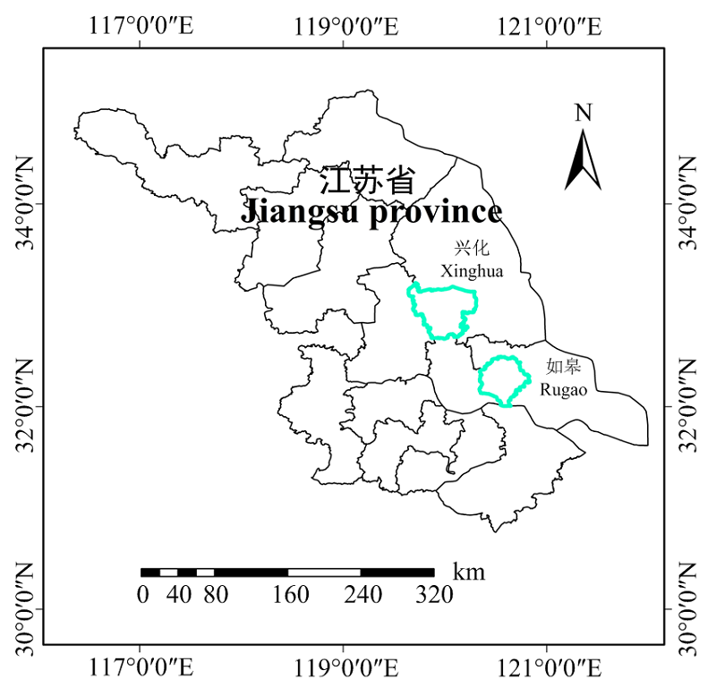
图1
研究区地理位置"

图2
2016年如皋试验小区设置及激光雷达扫描点分布图 氮水平:N0(0),N1(100 kg·hm-2),N2(200 kg·hm-2);品种:V1(武运粳24),V2(Y两优1号) "
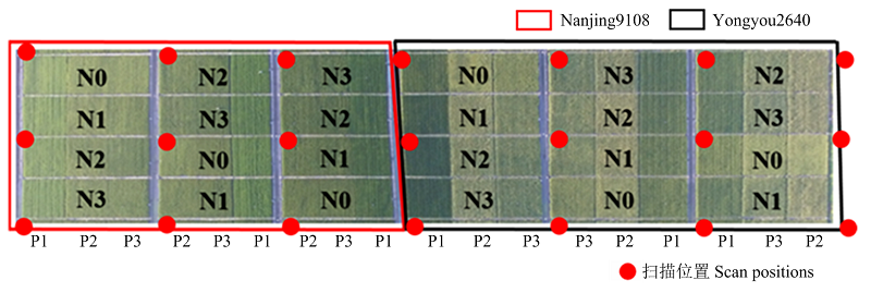
图3
2017年兴化试验小区设置及激光雷达扫描点分布图 氮水平:N0(0),N1(135 kg·hm-2),N2(270 kg·hm-2),N3(405 kg·hm-2);品种:V1(南粳9108),V2(甬优2640);播栽方式:P1(直播),P2(钵苗移栽),P3(毯苗移栽) "
表1
估算水稻产量的常用植被指数"
| 指数 Vegetation index | 计算公式 Equation | 文献 Reference |
|---|---|---|
| 差值Deviation | ||
| DVI [1200,680] | R1200-R680 | [ |
| DVI [1200,440] | R1200-R440 | [ |
| DVI [800,550] | R800-R550 | [ |
| 比值Ratio | ||
| SR [609,518] | (R609/R518)-1 | [ |
| SR [1971,2018] | (R1971/R2018)-1 | [ |
| SR [750,673] | R750/R673 | [ |
| 归一化Normalization | ||
| NDVI [1200,550] | (R1200-R550)/(R1200+R550) | [ |
| NDVI[800,680] | (R800-R680)/(R800+R680) | [ |
| NDVI [608,518] | (R609-R518)/(R609+R518) | [ |
表2
基于冠层高度模型提取的特征变量"
| 结构参数 Structural parameter | 描述 Description |
|---|---|
| Height mean ( Hmean) | 高度平均值 Mean of height |
| Height min (Hmin) | 高度最小值 Minimum of height |
| Height max (Hmax) | 高度最大值 Maximum of height |
| Height standard deviation (Hstd) | 高度标准偏差 Standard deviation of height |
| Height coefficient of variation (Hcov) | 高度变异系数 Variable coefficient of height |
| Height kurtosis (Hk) | 高度峰度 Kurtosis of height |
| Height skewness (Hs) | 高度偏度 Skewness of height |
| Height percentile (H1st, H5th, H10th, H25th, H50th, H75th, H95th, H99th) | 高度1st, 5th, 10th, 25th, 50th, 75th, 95th, 和99th 百分位 Percent of 1st, 5th, 10th, 25th, 50th, 75th, 95th, and 99th height |
表3
数据集描述"
| 数据集 Dataset | 年份 Year | 试验地点 Site | 样本数 Number of samples | 品种 Variety | 播栽方式 Planting technique |
|---|---|---|---|---|---|
| 训练数据集 Training dataset | 2017 | 兴化Xinghua | 72 | 南粳9108 & 甬优2640 Nanjing 9108 & Yongyou 2640 | 钵苗移栽Tray seeding transplanting、 毯苗移栽Blanket seeding transplanting、 直播Direct seeding |
| 验证数据集1 Validation dataset 1 | 2016 | 如皋Rugao | 36 | 武运粳24 & Y两优1号 Wuyunjing 24 & Y Liangyou 1 | 旱育秧人工移栽 Dried-seedling manual transplanting |
| 验证数据集2 Validation dataset 2 | 2018 | 兴化Xinghua | 48 | 南粳9108 & 甬优2640 Nanjing 9108 & Yongyou 2640 | 钵苗移栽Tray seedling transplanting、 毯苗移栽Blanket seeding transplanting |
表4
水稻产量与已有植被指数的相关性"
| 植被指数 Vegetation index | 抽穗期 Heading | 灌浆前期 Early filling | 灌浆后期 Late filling |
|---|---|---|---|
| R1200-R680 | 0.12* | 0.41** | 0.23** |
| R1200-R440 | 0.10* | 0.46** | 0.24** |
| R800-R550 | 0.17** | 0.41** | 0.52** |
| (R609/R518)-1 | 0.20** | ns | 0.01 |
| R750/R673 | 0.16** | 0.29** | 0.27** |
| (R1971/R2018)-1 | 0.03 | 0.04 | 0.02 |
| (R1200-R550)/(R1200+R550) | 0.17** | 0.31** | 0.28** |
| (R800-R680)/(R800+R680) | 0.12** | 0.32** | 0.23** |
| (R609-R518)/(R609+R518) | 0.16** | ns | 0.01 |
表5
水稻产量与小波特征的相关性"
| 抽穗期 Heading | 灌浆前期 Early filling | 灌浆后期 Late filing | |
|---|---|---|---|
| 最优小波特征 Optimal wavelet feature | WF730,3 | WF1200,3 | WF1185,3 |
| R2 | 0.34** | 0.58** | 0.58** |
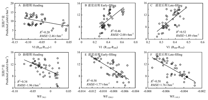
图4
最优植被指数(A、B、C)及最优小波特征(D、E、F)水稻产量的回归关系"
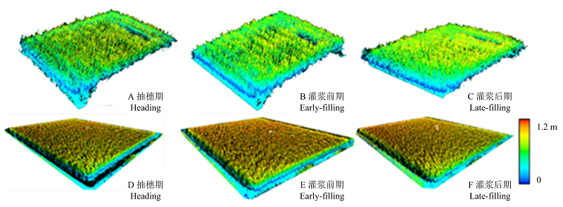
图5
如皋某小区抽穗后(A、B、C)与兴化某小区抽穗后各生育期(D、E、F)的水稻点云数据,颜色依据高度赋值"
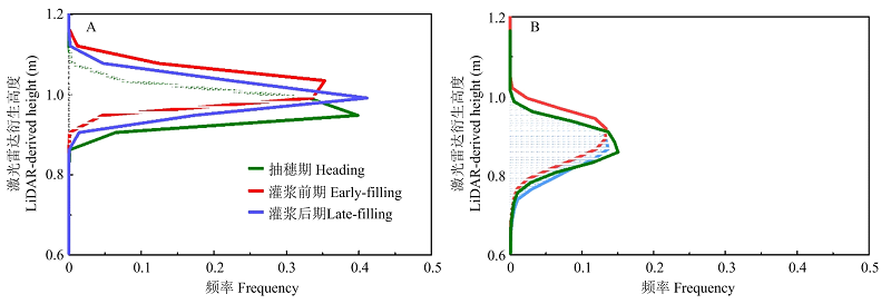
图6
兴化(A)与如皋(B)某小区的高度直方图"
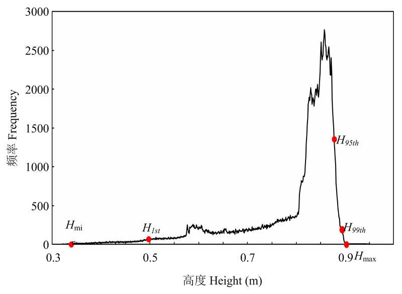
图7
结构参数Hmin、H1st、H95th、H99th、Hmax在高度直方图中的分布 "
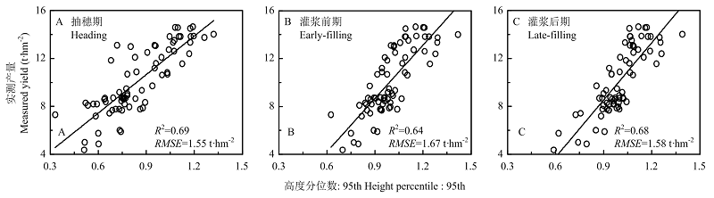
图8
结构参数在与水稻产量的回归关系"
表6
光谱数据产量模型应用于不同数据集得到的RMSE与RRMSE值 "
| 模型 Models | 如皋Rugao | 兴化Xinghua | ||||||||||
|---|---|---|---|---|---|---|---|---|---|---|---|---|
| 抽穗期Heading | 灌浆前期Early filling | 灌浆后期Late filling | 抽穗期Heading | 灌浆前期Early filling | 灌浆后期Late filling | |||||||
| RMSE | RRMSE | RMSE | RRMSE | RMSE | RRMSE | RMSE | RRMSE | RMSE | RRMSE | RMSE | RRMSE | |
| M11 (VI & LR) | 2.97 | 31.70 | 2.01 | 21.05 | 1.91 | 20.01 | 1.84 | 17.45 | 1.70 | 16.14 | 2.04 | 19.31 |
| M2 (VI & RF) | 3.07 | 32.20 | 2.18 | 22.90 | 2.16 | 22.65 | 2.14 | 20.30 | 3.04 | 28.84 | 2.25 | 21.30 |
| M3 (WF & LR) | 1.91 | 20.04 | 1.84 | 19.33 | 1.67 | 17.54 | 1.69 | 16.02 | 1.50 | 14.29 | 1.42 | 13.45 |
| M4 (WF & RF) | 3.04 | 31.92 | 2.37 | 24.88 | 2.10 | 21.10 | 2.11 | 20.00 | 2.05 | 19.42 | 1.93 | 18.29 |
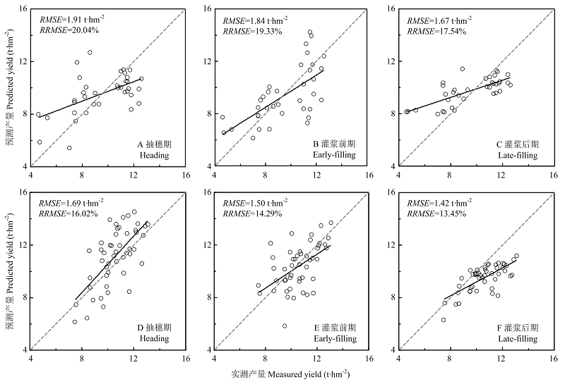
图9
基于小波特征的线性估算模型在如皋(A、B、C)以及兴化(D、E、F)数据集的验证结果"
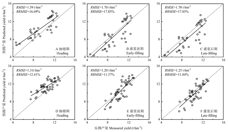
图10
基于结构参数的线性估算模型在如皋(A、B、C)以及兴化(D、E、F)的验证结果"
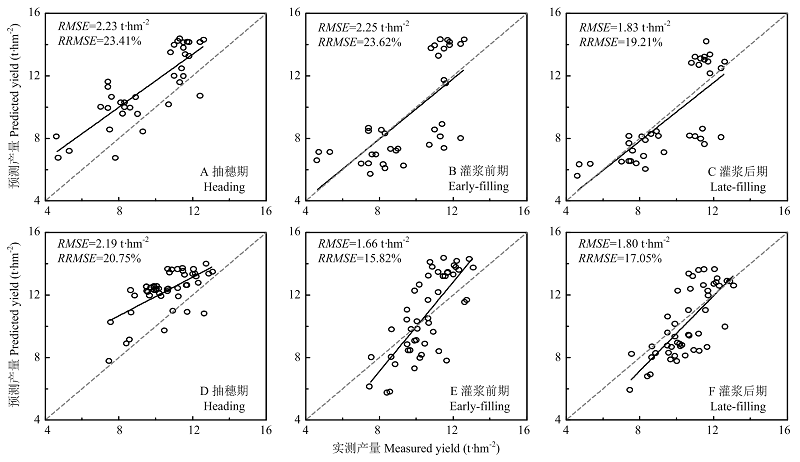
图11
基于结构参数的随机森林估算模型在如皋(A、B、C)以及兴化(D、E、F)的验证结果"
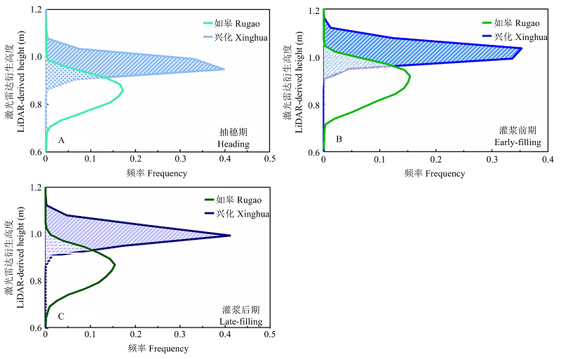
图12
如皋与兴化某小区抽穗后各生育期的高度直方图"
| [1] |
ALOLA A, ALOLA U V. The dynamic nexus of crop production and population growth: housing market sustainability pathway. Environmental Science and Pollution Research, 2018, 26:6472-6480.
doi: 10.1007/s11356-018-04074-1 |
| [2] | UN Food Agriculture Organization. How to feed the word in 2050. Discussion paper prepared for expert forum: 12-13. October 2009, released 23. |
| [3] | INTERPRETERS S. FAO-food and agriculture organization of the united nations. Science, 2013, 118(3077):13-23. |
| [4] | JULIAN P, MARK B, SARAH M. Food waste within food supply chains: quantification and potential for change to 2050. Philosophical Transactions of the Royal Society of London, 2010, 365(1554):3065-3081. |
| [5] |
LIU J G, PATTEY E, MILLER J R, MCNAIRN H, SMITH A, HU B X. Estimating crop stresses, aboveground dry biomass and yield of corn using multi-temporal optical data combined with a radiation use efficiency model. Remote Sensing of Environment, 2010, 114(6):1167-1177.
doi: 10.1016/j.rse.2010.01.004 |
| [6] |
MUTANGA O, ADAM E, CHO M A. High density biomass estimation for wetland vegetation using WorldView-2 imagery and random forest regression algorithm. International Journal of Applied Earth Observations and Geoinformation, 2012, 18(1):399-406.
doi: 10.1016/j.jag.2012.03.012 |
| [7] | 亓雪勇, 田庆久. 光学遥感大气校正研究进展. 国土资源遥感, 2005, 45(4):4-9. |
| QI X Y, TIAN Q J. The advance in the study of atmospheric correction for optical remote sensing. Remote Sensing for Land and Resources, 2005, 45(4):4-9. (in Chinese) | |
| [8] | 唐延林, 黄敬峰, 王人潮, 王福民. 水稻遥感估产模拟模式比较. 农业工程学报, 2004, 3(1):167-172. |
| TANG Y L, HUANG J F, WANG R C, WANG F M. Comparsion of yield estimation simulated models of rice by remote sensing. Transactions of The Chinese Society of Agricultural Engineering, 2004, 3(1):167-172. (in Chinese) | |
| [9] |
OWERS, C J, ROGERS K, WOODROFFE C D. Terrestrial laser scanning to quantify above-ground biomass of structurally complex coastal wetland vegetation. Estuarine Coastal and Shelf Science, 2018, 204:164-176.
doi: 10.1016/j.ecss.2018.02.027 |
| [10] |
EITEL J U H, MAGNEY T S, VIERLING L A, BROWN T T, HUGGINS D R. LiDAR based biomass and crop nitrogen estimates for rapid, non-destructive assessment of wheat nitrogen status. Field Crops Research, 2014, 159:21-32.
doi: 10.1016/j.fcr.2014.01.008 |
| [11] |
TILLY N, HOFFMEISTER D, CAO Q, LENZ-WIEDEMANN V, BARETH G. Precise plant height monitoring and biomass estimation with Terrestrial Laser Scanning in paddy rice. ISPRS Annals of the Photogrammetry, Remote Sensing and Spatial Information Sciences, 2013, II-5/W2:295-300.
doi: 10.5194/isprsannals-II-5-W2-295-2013 |
| [12] |
TILLY N, AASEN H, BARETH G. Fusion of plant height and vegetation indices for the estimation of barley biomass. Remote Sensing, 2015, 7:11449-11480.
doi: 10.3390/rs70911449 |
| [13] | GUO Q H, WU F F, PANG S X, ZHAO X Q, CHEN L H, LIU J, XUE B L, XU G C, LI L, JING H C. Crop 3D: a platform based on LiDAR for 3D high-throughput crop phenotyping. Scientia Sinica, 2016, 12:121-141. |
| [14] |
LUMME J, KARJALAINEN M, KAARTINEN H, KUKKO A, HYYPPÄ J, HYYPPÄ H, JAAKKOLA A, KLEEMOLA J. Terrestrial laser scanning of agricultural crops. International Journal of Remote Sensing, 2008, 26(7):563-566.
doi: 10.1080/01431160512331299270 |
| [15] |
MCKINION J M, WILLERS J L, JENKINS J N. Comparing high density LIDAR and medium resolution GPS generated elevation data for predicting yield stability. Computers and Electronics in Agriculture, 2010, 74(2):244-249.
doi: 10.1016/j.compag.2010.08.011 |
| [16] | LI Z H, WANG J H, XU X G, ZHAO C J, JIN X L, YANG G J, FENG H K. Assimilation of two variables derived from hyperspectral data into the DSSAT-CERES model for grain yield and quality estimation. Remote Sensing, 2015, 35(9):12400-12418. |
| [17] | 王延颐. 植被指数与水稻长势及产量结构要素关系的研究. 国土资源遥感, 1996, 2(1):56-59. |
| WANG Y Y. The relationship between vegetation index and rice growth and rice yield components. Remote Sensing for Land and Resources, 1996, 2(1):56-59. (in Chinese) | |
| [18] | 李卫国, 王纪华, 赵春江, 李存军, 王永华. 基于生态因子的冬小麦产量遥感估测研究. 麦类作物学报, 2009, 29(5):213-220. |
| LI W G, WANG J H, ZHAO C J, LI C J, WANG Y H. Study on remote sensing estimation of winter wheat yield based on eco-environmental factors. Journal of Triticeae Crop, 2009, 29(5):213-220. (in Chinese) | |
| [19] | 薛利红, 曹卫星, 罗卫红. 基于冠层反射光谱的水稻产量预测模型. 遥感学报, 2005, 7(1):102-107. |
| XUE L H, CAO W X, LUO W H. Rice yield forecasting model with canopy reflectance spectra. Journal of Remote Sensing, 2005, 7(1):102-107. (in Chinese) | |
| [20] |
CHENG T, RIVARD B, SÁNCHEZ-AZOFEIFA A G, FÉRET J B, JACQUEMOUD S, USTIN S L. Deriving leaf mass per area (LMA) from foliar reflectance across a variety of plant species using continuous wavelet analysis. ISPRS Journal of Photogrammetry and Remote Sensing, 2014, 87:28-38.
doi: 10.1016/j.isprsjprs.2013.10.009 |
| [21] | 宋开山, 刘殿伟, 王宗明, 吕冬梅, 张柏, 任春颖, 杜嘉. 基于小波分析的玉米叶绿素a与LAI高光谱反演模型研究. 农业系统科学与综合研究, 2011, 3(2):28-34. |
| SONG K S, LIU D W, WANG Z M, LÜ D M, ZHANG B, REN C Y, DU J. Corn chlorophyll-a concentration and LAI estimation models based on wavelet transformed canopy hyperspectral reflectance. System Sciences and Comprehensive Studies in Agriculture, 2011, 3(2):28-34. (in Chinese) | |
| [22] | 宋开山, 张柏, 王宗明, 刘殿伟, 刘焕军. 基于小波分析的大豆叶绿素a含量高光谱反演模型. 植物生态学报, 2008, 2(1):157-165. |
| SONG K S, ZHANG B, WANG Z M, LIU D W, LIU H J. Soybean chlorophyll a concentration estimation models based on wavelet- transformed, in situ collected, canopy hyperspectral data. Journal of Plant Ecology, 2008, 2(1):157-165. (in Chinese) | |
| [23] | 洪雪. 基于水稻高光谱遥感数据的植被指数产量模型研究[D]. 沈阳: 沈阳农业大学, 2017. |
| HONG X. Rice yield model research based on vegetation index of hyperspectral remote sensing data[D]. Shenyang: Shenyang Agricultural University, 2017. (in Chinese) | |
| [24] | 王娣. 高光谱与多光谱遥感水稻估产研究[D]. 武汉: 武汉大学, 2017. |
| WANG D. Hyperspectral and multispectral remote sensing study on yield estimation of rice[D]. Wuhan: Wuhan University, 2017. (in Chinese) | |
| [25] | 黄春燕, 王登伟, 陈冠文, 袁杰, 祁亚琴, 陈燕, 程诚. 基于高光谱植被指数的棉花干物质积累估算模型研究. 棉花学报, 2006, 18(2):115-119. |
| HUANG C Y, WANG D W, CHEN G W, YUAN J, QI Y Q, CHEN Y, CHENG C. Estimation modeling of cotton dry matter accumulation based on hyperspectral vegetation index. Cotton Science, 2006, 18(2):115-119. (in Chinese) | |
| [26] | 许童羽, 洪雪, 陈春玲, 周云成, 曹英丽, 于丰华, 李娜. 基于冠层NDVI数据的北方粳稻产量模型研究. 浙江农业学报, 2016, 28(10):1790-1795. |
| XU T Y, HONG X, CHEN C L, ZHOU Y C, CAO Y L, YU F H, LI N. Study on northern japonica rice yield model based on canopy date of NDVI. Acta Agriculturae Zhejiangensis, 2016, 28(10):1790-1795. (in Chinese) | |
| [27] | 宋红燕, 胡克林, 彭希. 基于高光谱技术的覆膜旱作水稻植株氮含量及籽粒产量估算. 中国农业大学学报, 2016, 4(8):27-34. |
| SONG H Y, HU K L, PENG X. Crop nitrogen content diagnosis and yield estimation in ground cover rice production system based on hyperspectral data. Journal of China Agricultural University, 2016, 4(8):27-34. (in Chinese) | |
| [28] |
SHIBAYAMA M. AKIYAMA T. Estimating grain yield of maturing rice canopies using high spectral resolution reflectance measurements. Remote Sensing of Environment, 1991, 36(1):45-53.
doi: 10.1016/0034-4257(91)90029-6 |
| [29] |
BAI J H, LI S K, WANG K R, SUI X Y, CHEN B, WANG F Y. Estimating aboveground fresh biomass of different cotton canopy types with homogeneity models based on hyper spectrum parameters. Agricultural Sciences in China, 2007, 6(4):437-445.
doi: 10.1016/S1671-2927(07)60067-4 |
| [30] | LI P, ZHANG X, WANG W H, ZHENG H B, YAO X, TIAN Y C, ZHU Y, CAO W X, CHEN Q, CHENG T. Estimating aboveground and organ biomass of plant canopies across the entire season of rice growth with terrestrial laser scanning. International Journal of Applied Earth Observation and Geoinformation, 2020, 91:102-132. |
| [31] | GITELSON A A, VIÑA A, ARKEBAUER T J, RUNDQUIST D C, KEYDAN G P, LEAVITT B, KEYDAN G. Remote estimation of leaf area index and green leaf biomass in maize canopies. Geophysical Research Letters, 2003, 30:335-343. |
| [32] |
HUDAK A T, LEFSKY M A, COHEN W B, BERTERRETCHE M. Integration of LiDAR and Landsat ETM+ data for estimating and mapping forest canopy height. Remote Sensing of Environment, 2015, 82(2/3):397-416.
doi: 10.1016/S0034-4257(02)00056-1 |
| [33] |
WEI F, HUI F, YANG W N, DUAN L F, CHEN G X, XIONG L Z, LIU Q. High-throughput volumetric reconstruction for 3D wheat plant architecture studies. Journal of Innovative Optical Health Sciences, 2016, 9(5):1650037.
doi: 10.1142/S1793545816500371 |
| [34] |
HUANG J F, BLACKBURN G A. Optimizing predictive models for leaf chlorophyll concentration based on continuous wavelet analysis of hyperspectral data. International Journal of Remote Sensing, 2011, 32(24):9375-9396.
doi: 10.1080/01431161.2011.558130 |
| [35] |
CHEN Q. Modeling aboveground tree woody biomass using national- scale allometric methods and airborne LiDAR. ISPRS Journal of Photogrammetry and Remote Sensing, 2015, 106:95-106.
doi: 10.1016/j.isprsjprs.2015.05.007 |
| [36] | DAI B, GU C S, ZHAO E, QIN X N. Statistical model optimized random forest regression model for concrete dam deformation monitoring. Structural Control and Health Monitoring, 2018, 25(6):1-15. |
| [37] |
TILLY N, HOFFMEISTER D, CAO Q, LENZ-WIEDEMANN V, MIAO Y X, BARETH G. Transferability of models for estimating paddy rice biomass from spatial plant height data. Agriculture, 2015, 5:538-552.
doi: 10.3390/agriculture5030538 |
| [1] | 彭廷燊, 陆久焱, 吴美林, 严雨欣, 刘宏周, 南文斌, 秦小健, 李明, 龚俊义, 梁永书. 多年生水稻黄糯2号和长白7号产量相关性状的QTL分析[J]. 中国农业科学, 2026, 59(7): 1361-1379. |
| [2] | 王玉萍, 符质, 孙佳莹, 穆晓萌, 刘慧淋, 郭进云, 宋文菁, 侯雷平, 赵海亮. 苗期施用褪黑素对番茄短期低温胁迫的缓解作用与应用效果评价[J]. 中国农业科学, 2026, 59(7): 1523-1535. |
| [3] | 王佳诺, 陈桂平, 李盼, 王丽萍, 南运有, 何蔚, 樊志龙, 胡发龙, 柴强, 殷文, 赵连豪. 免耕地膜两年覆盖提高绿洲灌区玉米产量的灌浆期光合生理机制[J]. 中国农业科学, 2026, 59(6): 1189-1202. |
| [4] | 周新杰, 任昊, 陈应龙, 张吉旺, 赵斌, 任佰朝, 刘鹏, 王洪章. 过氧化钙对渍涝农田夏玉米根系形态及产量形成的影响[J]. 中国农业科学, 2026, 59(6): 1203-1216. |
| [5] | 何继航, 张擎, 吕相月, 薛吉全, 徐淑兔, 刘建超. 不同保绿型玉米杂交种氮效率评价[J]. 中国农业科学, 2026, 59(6): 1217-1230. |
| [6] | 陈敏, 焦紫岚, 乔承彬, 许昊, 张碧, 马东花, 孔维儒, 王敬文, 宋佳伟, 罗成科, 李培富, 田蕾. 不同亚种水稻种质资源对盐胁迫的形态生理响应及适应策略[J]. 中国农业科学, 2026, 59(4): 705-722. |
| [7] | 郭富城, 唐海江, 郝馨怡, 马国林, 杨九菊, 黄霖锋, 田蕾, 王彬, 罗成科. 不同灌溉方式对宁夏盐渍化土壤水盐运移、水稻产量及水分利用效率的影响[J]. 中国农业科学, 2026, 59(4): 750-764. |
| [8] | 钱瑾, 李映雪, 吴芳, 邹晓晨. 集成光谱降维的冬小麦叶片磷含量估算[J]. 中国农业科学, 2026, 59(4): 781-792. |
| [9] | 张卫建, 严圣吉, 尚子吟, 唐志伟, 吴柳格, 李佳锐, 陈浩天, 邓艾兴, 张俊, 张鑫, 郑成岩, 宋振伟. 稻田甲烷不完全源于水稻种植的人为贡献[J]. 中国农业科学, 2026, 59(4): 824-833. |
| [10] | 郝琨, 陈洪德, 张威, 钟韵, 党美荣, 朱士江, 黄志坤, 金英. 基于柑橘产量、品质及水氮利用的涌泉根灌水氮综合评价[J]. 中国农业科学, 2026, 59(4): 862-873. |
| [11] | 朱姝, 国志鹏, 孙颖. 水稻雷帕霉素靶蛋白OsTOR调控根伸长的功能研究[J]. 中国农业科学, 2026, 59(3): 475-485. |
| [12] | 延廷霖, 杜娅丹, 胡笑涛, 王贺, 李晓雁, 王玉明, 牛文全, 谷晓博. 加气滴灌下氮肥有机替代对亏缺灌溉棉花产量和水分利用效率的影响[J]. 中国农业科学, 2026, 59(3): 602-618. |
| [13] | 吕文彦, 程海涛, 马兆惠, 田淑华. 育种新时代水稻杂交育种技术与策略探讨[J]. 中国农业科学, 2026, 59(2): 233-238. |
| [14] | 廖婷璐, 石亚飞, 肖东浩, 舍杨梦斐, 郭富城, 杨九菊, 唐海江, 罗成科. 外源硝普钠对碱胁迫下水稻幼苗糖代谢的影响[J]. 中国农业科学, 2026, 59(2): 265-277. |
| [15] | 蔡廷阳, 朱玉鹏, 李瑞东, 吴宗声, 徐一帆, 宋雯雯, 徐彩龙, 吴存祥. 苗期叶损伤对黄淮海夏大豆光合特性、荚果分布及产量形成的影响[J]. 中国农业科学, 2026, 59(2): 292-304. |
|
||