


中国农业科学 ›› 2022, Vol. 55 ›› Issue (24): 4823-4839.doi: 10.3864/j.issn.0578-1752.2022.24.004
王淑婷1( ),孔雨光2,张赞3,陈红艳1(),刘鹏4
收稿日期:2022-01-17
接受日期:2022-06-06
出版日期:2022-12-16
发布日期:2023-01-04
联系方式:
王淑婷,E-mail:wstwang@163.com。
基金资助:
WANG ShuTing1(),KONG YuGuang2,ZHANG Zan3,CHEN HongYan1(),LIU Peng4
Received:2022-01-17
Accepted:2022-06-06
Published:2022-12-16
Online:2023-01-04
摘要:
【目的】为提高棉花叶片叶绿素含量的反演精度,并掌握其在山东省夏津县的空间分布特征。【方法】本研究以山东省德州市夏津县为研究区,以夏津县大李庄棉田为试验区,通过SPAD(soil and plant analyzer development,SPAD)仪实地测定试验区棉花叶片叶绿素含量的相对值(SPAD值),并获取同期试验区无人机(unmanned aerial vehicle,UAV)近地多光谱图像和研究区Sentinel-2A MSI(MSI)卫星影像;然后分别基于UAV和MSI的光谱反射率,构建并筛选最优光谱参量,采用多元线性回归(multiple linear regression,MLR)建立SPAD值定量反演模型;最后采用二次多项式拟合法融合UAV和Sentinel-2A MSI对应的最优光谱参量,对比分析融合前后模型效果,优选最佳反演模型,实现研究区SPAD值反演。【结果】研究表明,(REG-R)/(REG+R)、R/G、CL(red edge)、NDVI可作为SPAD值的最优光谱参量;基于UAV图像的定量反演模型精度优于基于MSI影像的模型;基于二次多项式拟合后建模R 2提高了0.015—0.057,RMSE降低了0.457—0.638,验证R 2提高了0.040—0.085,RMSE降低了0.387—0.397,RPD提高了0.020—0.139;将融合后的MSI光谱参量代入基于UAV图像的反演模型(Fused MSI-ModUAV),也可获得较高的反演精度,建模R 2达0.672,RMSE为3.982,验证R 2达0.713,RMSE为3.859,RPD为1.685;基于上述模型进行研究区棉花叶片SPAD值反演分析,试验区整体呈南高北低的分布趋势,研究区呈中间低、四周高的分布趋势,均与实地情况一致,具有较好的预测效果。【结论】采用二次多项式拟合法融合无人机和卫星影像数据,可较好地实现区域高精度作物生长指标的定量反演,研究结果可丰富多源遥感融合理论与技术,为后续棉花长势监测与精准生产提供技术参考和数据支持。
王淑婷, 孔雨光, 张赞, 陈红艳, 刘鹏. 基于星-机光谱融合的棉花叶片SPAD值反演[J]. 中国农业科学, 2022, 55(24): 4823-4839.
WANG ShuTing, KONG YuGuang, ZHANG Zan, CHEN HongYan, LIU Peng. SPAD Value Inversion of Cotton Leaves Based on Satellite-UAV Spectral Fusion[J]. Scientia Agricultura Sinica, 2022, 55(24): 4823-4839.
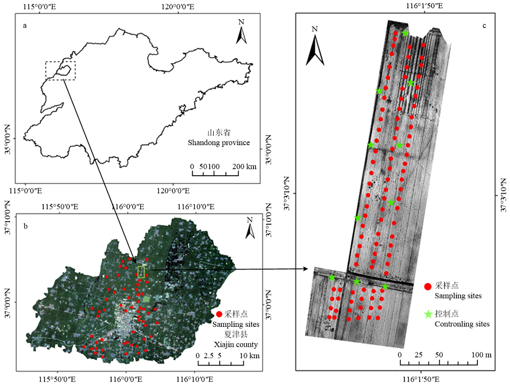
图1
研究区、试验区地理位置(a:山东省;b:研究区;c:试验区)"
表1
UAV与Sentinal-2A MSI波段对应关系"
| 波段名称 Band name | 无人机 UAV | 卫星 Sentinel-2A MSI | ||||
|---|---|---|---|---|---|---|
| 波段 Band | 中心波长 Central wavelength (nm) | 带宽 Bandwidth (nm) | 波段 Band | 中心波长 Central wavelength (nm) | 带宽 Bandwidth (nm) | |
| G | Green | 550 | 40 | B3-Green | 560 | 45 |
| R | Red | 660 | 40 | B4-Red | 665 | 38 |
| REG | Red Edge | 735 | 10 | B6-Vegetation Red Edge | 740 | 18 |
| NIR | Near IR | 790 | 40 | B7- Vegetation Red Edge | 783 | 28 |
表2
光谱参量及其计算公式"
| 植被指数 Vegetation index | 名称 Name | 计算公式 Calculation formula | 参考文献 Reference |
|---|---|---|---|
| RVI | 比值植被指数 Ratio vegetation index | NIR/R | [ |
| DVI | 差值植被指数 Difference vegetation index | NIR-R | |
| GNDVI | 绿色归一化植被指数 Green normalized difference vegetation index | (NIR-G)/(NIR+R) | |
| NDRE | 红边植被指数 Normalized difference red edge | (NIR-REG)/(NIR+REG) | [ |
| CL(red edge) | 红边叶绿素指数Ⅱ Red edge chlorophyII index | REG/R-1 | [ |
| MCARI | 改进叶绿素吸收比值指数 Modified chlorophyII absorption ratio index | [(REG-R)-0.2×(REG-G)] ×(REG/R) | |
| TCARI | 转化叶绿素吸收比值指数 Transformed chlorophyII absorption ratio index | 3×[(REG-R)-0.2×(REG-G)×(REG/R)] | |
| OSAVI | 优化型土壤调节植被指数 Optimized soil adjusted vegetation index | 1.16×(NIR-R)/(NIR+R+0.16) | |
| NDVI | 归一化植被指数 Normalized difference vegetation index | (NIR-R)/(NIR+R) | |
| CIRE | 红边叶绿素指数Ⅰ Red edge chlorophyII index | NIR/REG-1 | [ |
| MSR | 改进简单比值植被指数 Modified simple ratio | (NIR/R-1)(NIR/R+1)0.5 | [ |
| RDVI | 重归一化植被指数 Renormalized difference vegetation index | (NIR-R)/(NIR+R)0.5 | |
| (REG-R)/(REG+R) | — | (REG-R)/(REG+R) | [ |
| R/G | — | R/G | |
| sqrt(R2+G^2) | — | sqrt(R^2+G^2) | |
| G×R | — | G×R | |
| G×R×REG | — | G×R×REG | |
| REG-R | — | REG-R | |
| REG-NIR | — | REG-NIR |
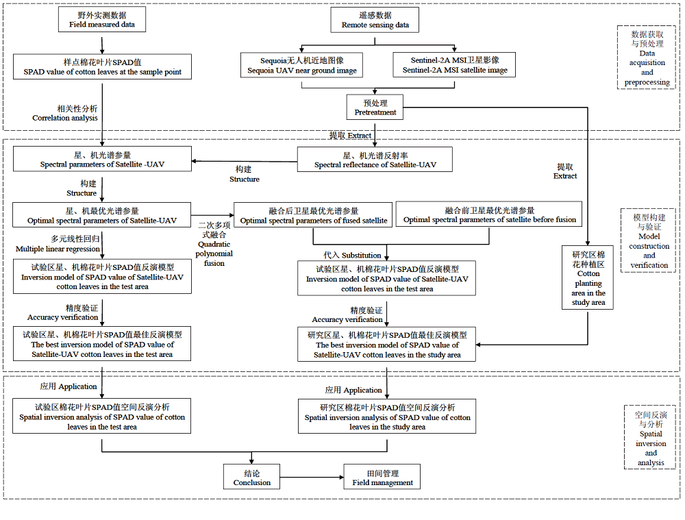
图2
技术路线图"
表3
样本棉花叶片SPAD值统计分析"
| 样本类型 Sample type | 样本数 Number of samples | 最大值 Maximum value | 最小值 Minimum value | 平均值 Average value | 标准差 Standard deviation |
|---|---|---|---|---|---|
| 建模集 Calibration set | 64 | 59.5 | 20.2 | 43.5 | 7.8 |
| 验证集 Validation set | 31 | 68.2 | 17.1 | 43.3 | 8.3 |
| 全部 All the samples | 95 | 68.2 | 17.1 | 43.3 | 8.6 |
| 研究区 Study area | 58 | 63.1 | 21.5 | 46.9 | 8.1 |
表4
光谱参量与样本实测SPAD值的相关性分析"
| 序号 Number | 光谱参量 Spectral parameter | 相关系数 Correlation coefficient | |
|---|---|---|---|
| 无人机 UAV | 卫星 Sentinel-2A MSI | ||
| 1 | NDVI | 0.688** | 0.559** |
| 2 | RVI | 0.655** | 0.518* |
| 3 | DVI | 0.300 | 0.558* |
| 4 | MSR | 0.683** | 0.534 |
| 5 | RDVI | 0.530* | 0.553* |
| 6 | GNDVI | -0.613 | 0.542 |
| 7 | CIRE | -0.547* | 0.411 |
| 8 | OSAVI | 0.531* | 0.545* |
| 9 | CL(red edge) | 0.756** | 0.549* |
| 10 | MCARI | 0.687** | 0.517* |
| 11 | TCARI | -0.490 | -0.496 |
| 12 | NDRE | -0.196 | 0.412 |
| 13 | (REG-R)/(REG+R) | 0.800** | 0.557** |
| 14 | R/G | -0.768** | -0.547** |
| 15 | sqrt(R^2+G^2) | -0.653** | -0.529* |
| 16 | G×R | -0.626** | -0.541* |
| 17 | G×R×REG | -0.405 | -0.510 |
| 18 | REG-R | 0.680** | 0.548** |
| 19 | REG-NIR | 0.023 | -0.505* |
表5
棉花叶片SPAD值反演模型"
| 数据源 Data source | 反演模型 Inversion model | 建模精度 Calibration accuracy | 验证精度 Verification accuracy | ||||
|---|---|---|---|---|---|---|---|
| 决定系数 R2 | 均方根误差RMSE | 决定系数 R2 | 均方根误差RMSE | 相对分析误差 RPD | |||
| 无人机 UAV | Y=37.362+1.093×NDVI+1.26×CL(red edge)- 4.946×R/G+8.286×(REG-R)/(REG+R) | 0.709 | 3.782 | 0.753 | 3.589 | 2.045 | |
| 卫星 Sentinel-2A MSI | Y=-39.914+152.318×NDVI-2.267×CL(red edge)- 4.990×R/G-25.234×(REG-R)/(REG+R) | 0.452 | 5.823 | 0.447 | 5.909 | 1.521 | |
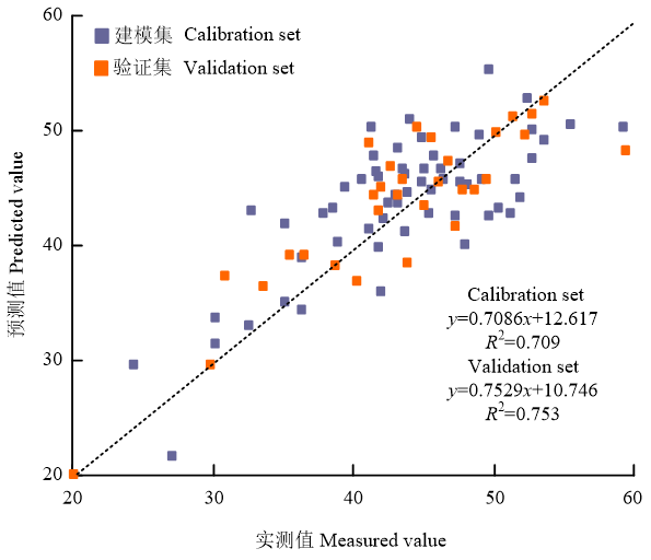
图3
试验区样点SPAD值散点图"
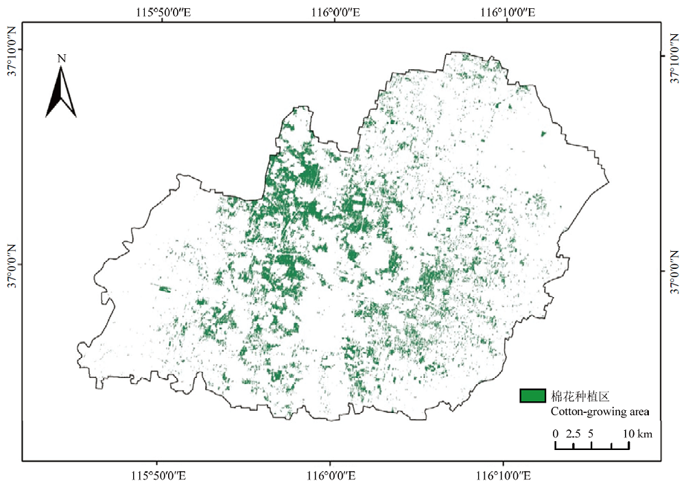
图4
研究区棉花种植区分布图"
表6
棉花种植区提取混淆矩阵"
| 区域 Region | 棉花种植区 Cotton-growing area | 非棉花种植区 Non cotton-growing area | 样本总数 Total number of samples |
|---|---|---|---|
| 棉花种植区 Cotton-growing area | 1007 | 60 | 1067 |
| 非棉花种植区 Non cotton-growing area | 12 | 1360 | 1372 |
| 样本总数 Total number of samples | 1019 | 1420 | 2439 |
表7
融合前后的特征光谱参量"
| 最优光谱参量 Optimal spectral parameter | 光谱转换公式 Spectral conversion formula | 融合前 Unfused | 融合后 Fused | ||
|---|---|---|---|---|---|
| 拟合度R2 Fitting degree | 相关系数 Correlation coefficient | 拟合度R2 Fitting degree | 相关系数 Correlation coefficient | ||
| NDVI | NDVI′= 0.325×NDVI2+0.2682×NDVI+0.4053 | 0.704 | 0.559** | 0.721 | 0.580** |
| CL(red edge) | CL(red edge)′=-0.2687×CL(red edge)2+3.0079×CL (red edge) -0.821 | 0.670 | 0.549** | 0.714 | 0.611** |
| R/G | R/G′=-0.0682×R/G2+0.4316×R/G+0.3128 | 0.697 | -0.547** | 0.712 | -0.587** |
| (REG-R)/(REG+R) | (REG-R)/(REG+R)′= 0.4694×(REG-R)/(REG+R)2+ 0.1082×(REG-R)/(REG+R)+0.453 | 0.695 | 0.557** | 0.718 | 0.618** |
表8
研究区棉花叶片SPAD值反演模型"
| 模型 Model | 公式 Formula | 建模精度 Calibration accuracy | 验证精度 Verification accuracy | |||
|---|---|---|---|---|---|---|
| 决定系数 R2 | 均方根误差RMSE | 决定系数 R2 | 均方根误差RMSE | 相对分析误差 RPD | ||
| MSI-ModMSI | Y=-39.914+152.318×NDVI-2.267×CL(red edge)- 4.990×R/G-25.234×(REG-R)/(REG+R) | 0.452 | 5.823 | 0.447 | 5.909 | 1.521 |
| Fused MSI-ModMSI | Y=-39.914+152.318×NDVI′-2.267×CL(red edge)′- 4.990×R/G′-25.234×(REG-R)/(REG+R)′ | 0.467 | 5.366 | 0.487 | 5.522 | 1.541 |
| MSI-ModUAV | Y=37.362+1.093×NDVI+1.26×CL(red edge)- 4.946×R/G+8.286×(REG-R)/(REG+R) | 0.615 | 4.620 | 0.628 | 4.256 | 1.546 |
| Fused MSI-ModUAV | Y=37.362+1.093×NDVI′+1.26×CL(red edge)′- 4.946×R/G′+8.286×(REG-R)/(REG+R)′ | 0.672 | 3.982 | 0.713 | 3.859 | 1.685 |
| AR Fused MSI-ModUAV | Y=37.362+1.066×NDVI+5.388×CL(red edge)- 3.645×R/G+18.652×(REG-R)/(REG+R) | 0.638 | 4.259 | 0.664 | 4.015 | 1.598 |
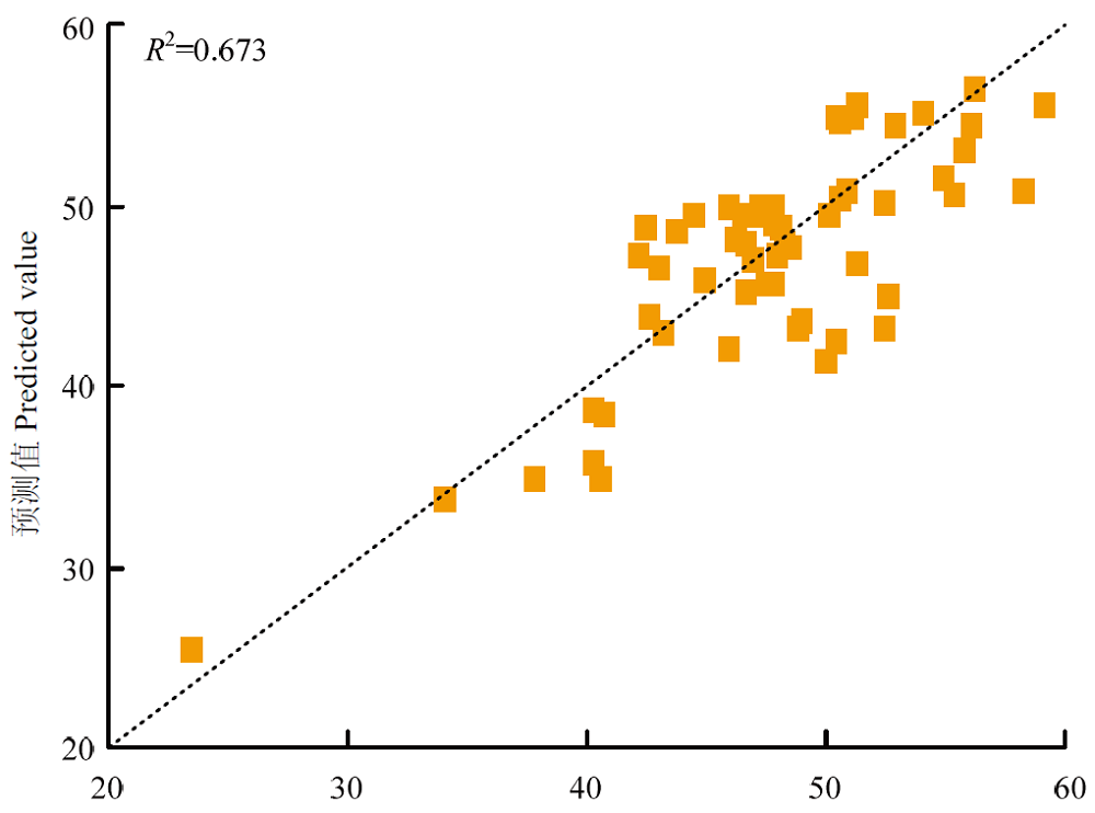
图5
研究区样点SPAD值散点图"

图6
试验区棉花叶片SPAD值反演图"
表9
试验区棉花叶片SPAD值分级统计"
| 等级 Level | 反演值 Inversion value | 样点实测值 Measured value of sample point | 样点预测值 Predicted values of sample points | |||
|---|---|---|---|---|---|---|
| 像元数 Number of pixels | 所占比例 Proportion (%) | 个数 Number | 所占比例 Proportion (%) | 个数 Number | 所占比例 Proportion (%) | |
| <30 | 664632 | 6.747 | 6 | 6.316 | 4 | 4.210 |
| 30-40 | 1829536 | 18.574 | 17 | 17.895 | 17 | 17.895 |
| 40-50 | 6483804 | 65.825 | 55 | 57.895 | 62 | 65.263 |
| >50 | 872169 | 8.854 | 17 | 17.894 | 12 | 12.632 |
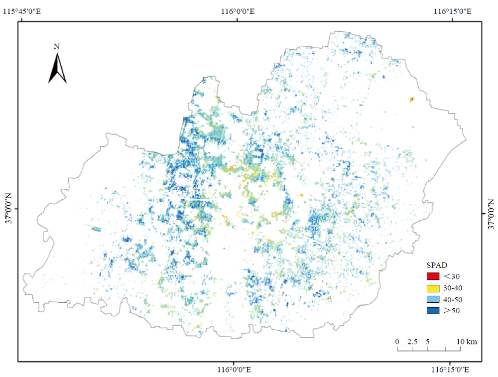
图7
研究区棉花叶片SPAD值反演图"
表10
研究区棉花叶片SPAD值分级统计"
| 等级 Level | 反演图 Inversion map | |
|---|---|---|
| 像元数 Number of pixels | 所占比例 Proportion (%) | |
| <30 | 15749 | 1.395 |
| 30-40 | 186849 | 16.553 |
| 40-50 | 492603 | 43.640 |
| >50 | 433588 | 38.412 |
| [1] | 苏伟, 赵晓凤, 孙中平, 张明政, 邹再超, 王伟, 史园莉. 基于Sentinel-2A影像的玉米冠层叶绿素含量估算. 光谱学与光谱分析, 2019, 39(5): 1535-1542. |
| SU W, ZHAO X F, SUN Z P, ZHANG M Z, ZOU Z C, WANG W, SHI Y L. Estimating the corn canopy chlorophyll content using the Sentinel-2A image. Spectroscopy and Spectral Analysis, 2019, 39(5): 1535-1542. (in Chinese) | |
| [2] | 周敏姑, 邵国敏, 张立元, 刘治开, 韩文霆. 基于无人机遥感的冬小麦叶绿素含量多光谱反演. 节水灌溉, 2019, (9): 40-45. |
| ZHOU M G, SHAO G M, ZHANG L Y, LIU Z K, HAN W T. Multi-spectral inversion of SPAD value of winter wheat based on unmanned aerial vehicle remote sensing. Water Saving Irrigation, 2019, (9): 40-45. (in Chinese) | |
| [3] | 陈硕博. 无人机多光谱遥感反演棉花光合参数与水分的模型研究[D]. 西安: 西北农林科技大学, 2019. |
| CHEN S B. Modeling of cotton photosynthetic parameters and water content retrieval by multi-spectral remote sensing of UAV[D]. Xi’an: Northwest A&F University, 2019. (in Chinese) | |
| [4] |
HATAM Z, SABET M S, MALAKOUTI M J, BIDGOLI A M, HOMAEE M. Zinc and potassium fertilizer recommendation for cotton seedlings under salinity stress based on gas exchange and chlorophyll fluorescence responses. South African Journal of Botany, 2020, 130: 155-164.
doi: 10.1016/j.sajb.2019.11.032 |
| [5] | 鱼欢, 邬华松, 王之杰. 利用SPAD和Dualex快速、无损诊断玉米氮素营养状况. 作物学报, 2010, 36(5): 840-847. |
| YU H, WU H S, WANG Z J. Evaluation of SPAD and Dualex for in season corn nitrogen status estimation. Acta Agronomica Sinica, 2010, 36(5): 840-847. (in Chinese) | |
| [6] |
LI X J, DU H Q, ZHOU G M, MAO F J, ZHANG M, HAN N, FAN W L, LIU H, HUANG Z H, HE S B, MEI T T. Phenology estimation of subtropical bamboo forests based on assimilated MODIS LAI time series data. ISPRS Journal of Photogrammetry and Remote Sensing, 2021, 173(6): 262-277.
doi: 10.1016/j.isprsjprs.2021.01.018 |
| [7] |
KOTIKOT A M, FLORES A, GRIFFIN R E, SEDAH A, NYAGA J, MUGO R, LIMAYE A, IRWIN D E. Mapping threat to agriculture in East Africa: Performance of MODIS derived LST for frost identification in Kenya’s tea plantations. International Journal of Applied Earth Observation and Geoinformation, 2018, 72: 131-139.
doi: 10.1016/j.jag.2018.05.009 |
| [8] |
HOLZMAN M E, CARMONA F, RIVAS R, NICLOS R. Early assessment of crop yield from remotely sensed water stress and solar radiation data. ISPRS Journal of Photogrammetry and Remote Sensing, 2018, 145: 297-308.
doi: 10.1016/j.isprsjprs.2018.03.014 |
| [9] |
GHOSH S, MISHRA D R, GITELSON A A. Long-term monitoring of biophysical characteristics of tidal wetlands in the northern Gulf of Mexico—A methodological approach using MODIS. Remote Sensing of Environment, 2016, 173: 39-58.
doi: 10.1016/j.rse.2015.11.015 |
| [10] |
LIAQAT M U, CHEEMA M J M, HUANG W J, MAHMOOD T, ZAMAN M, KHAN M M. Evaluation of MODIS and Landsat multiband vegetation indices used for wheat yield estimation in Irrigated Indus Basin. Computers and Electronics in Agriculture, 2017, 138: 39-47.
doi: 10.1016/j.compag.2017.04.006 |
| [11] |
MOKHTARI A, NOORY H, POURSHAKOURI F, HAGHIGHATMEHE P, AFRASIABIAN Y, RAZAVI M, FEREYDOONI F, NAENI A S. Calculating potential evapotranspiration and single crop coefficient based on energy balance equation using Landsat 8 and Sentinel-2. ISPRS Journal of Photogrammetry and Remote Sensing, 2019, 154: 231-245.
doi: 10.1016/j.isprsjprs.2019.06.011 |
| [12] | 张卓然, 常庆瑞, 张延龙, 班松涛, 由明明. 基于支持向量机的棉花冠层叶片叶绿素含量高光谱遥感估算. 西北农林科技大学(自然科学版), 2018, 46(11): 39-45. |
| ZHANG Z R, CHANG Q R, ZHANG Y L, BAN S T, YOU M M. Hyperspectral estimation of chlorophyll remote sensing content of cotton canopy leaves based on support vector machine. Journal of Northwest A&F University (Natural Science Edition), 2018, 46(11): 39-45. (in Chinese) | |
| [13] | LIU J B, HAN J C, CHEN X, SHI L, ZHANG L. Nondestructive detection of rape leaf chlorophyll level based on Vis-NIR spectroscopy. Spectrochimica Acta Part A: Molecular and Biomolecular Spectroscopy, 2019, 222: 117202. |
| [14] | 张东彦, 宋晓宇, 马智宏, 杨贵军, 黄文江, 王纪华. 扫描成像光谱仪和地物光谱仪在单叶尺度上的对比研究. 中国农业科学, 2010, 43(11): 2239-2245. |
| ZHANG D Y, SONG X Y, MA Z H, YANG G J, HUANG W J, WANG J H. Assessment of the developed pushbroom imaging spectrometer in single leaf scale. Scientia Agricultura Sinica, 2010, 43(11): 2239-2245. (in Chinese) | |
| [15] | 唐普恩, 丁建丽, 葛翔宇, 张振华. 基于Sentinel-2A影像干旱区棉花叶片SPAD数字制图. 生态学报, 2020, 40(22): 8326-8335. |
| TANG P E, DING J L, GE X Y, ZHANG Z H. SPAD digital mapping of cotton leaves in arid area based on Sentinel-2A image. Acta Ecologica Sinica, 2020, 40(22): 8326-8335. (in Chinese) | |
| [16] |
MALHI R K M, KIRAN G S. Empirical modelling for retrieval of foliar traits in cotton crop using spatial data. Current Science, 2019, 116(12): 2089-2096.
doi: 10.18520/cs/v116/i12/2089-2096 |
| [17] |
BALLESTEROS R, ORTEGA J F, HERNANDEZ D. Onion biomass monitoring using UAV based RGB imaging. Precision Agriculture, 2018, 19(5): 840-857.
doi: 10.1007/s11119-018-9560-y |
| [18] | 奚雪, 赵庚星, 高鹏, 崔昆, 李涛. 基于Sentinel卫星及无人机多光谱的滨海冬小麦种植区土壤盐分反演研究——以黄三角垦利区为例. 中国农业科学, 2020, 53(24): 5005-5016. |
| XI X, ZHAO G X, GAO P, CUI K, LI T. Inversion of soil salinity in coastal winter wheat growing area based on sentinel satellite and unmanned aerial vehicle multi-spectrum—A case study in Kenli District of the Yellow River Delta. Scientia Agricultura Sinica, 2020, 53(24): 5005-5016. (in Chinese) | |
| [19] |
史舟, 徐冬云, 滕洪芬, 胡月明, 潘贤章, 张甘霖. 土壤星地传感技术现状与发展趋势. 地理科学进展, 2018, 37(1): 79-92.
doi: 10.18306/dlkxjz.2018.01.009 |
|
SHI Z, XU D Y, TENG H F, HU Y M, PAN X Z, ZHANG G L. Soil information acquisition based on remote sensing and proximal soil sensing: Current status and prospect. Progress in Geography, 2018, 37(1): 79-92. (in Chinese)
doi: 10.18306/dlkxjz.2018.01.009 |
|
| [20] | 陈俊英, 王新涛, 张智韬, 韩佳, 姚志华, 魏广飞. 基于无人机-卫星遥感尺度的土壤盐渍化监测方法. 农业机械学报, 2019, 50(12): 161-169. |
| CHEN J Y, WANG X T, ZHANG Z T, HAN J, YAO Z H, WEI G F. Soil salinization monitoring method based on UAV satellite remote sensing scale up. Transactions of the Chinese Society for Agricultural Machinery, 2019, 50(12): 161-169. (in Chinese) | |
| [21] | 田明璐, 班松涛, 常庆瑞, 马文君, 殷紫, 王力. 基于无人机成像光谱仪数据的棉花叶绿素含量反演. 农业机械学报, 2016, 47(11): 285-293. |
| TIAN M L, BAN S T, CHANG Q R, MA W J, YIN Z, WANG L. Estimation of SPAD value of cotton leaf using hyperspectral images from UAV based imaging spectroradiometer. Transactions of the Chinese Society for Agricultural Machinery, 2016, 47(11): 285-293. (in Chinese) | |
| [22] | 毛智慧, 邓磊, 孙杰, 张爱武, 陈向阳, 赵云. 无人机多光谱遥感在玉米冠层叶绿素预测中的应用研究. 光谱学与光谱分析, 2018, 38(9): 2923-2931. |
| MAO Z H, DENG L, SUN J, ZHANG A W, CHEN X Y, ZHAO Y. Research on the application of UAV multispectral remote sensing in the maize chlorophyll prediction. Spectroscopy and Spectral Analysis, 2018, 38(9): 2923-2931. (in Chinese) | |
| [23] | CHEN H Y, MA Y, ZHU A X, WANG Z R, GENG X Z, WEI Y N. Soil salinity inversion based on differentiated fusion of satellite image and ground spectra. International Journal of Applied Eaeth Observation and Geoinformation, 2021, 101(2): 1-11. |
| [24] | 齐小玲, 吴健平. 多源遥感影像融合及其关键技术探讨. 现代测绘, 2003, 26(3): 20-22. |
| QI X L, WU J P. Study on multi-source RS images fusion and its key techniques. Modern Surveying and Mapping, 2003, 26(3): 20-22. (in Chinese) | |
| [25] |
PENG Y, NGUY-ROBERTSON A, ARKEBAUER T, GITELSON A A. Assessment of canopy chlorophyll content retrieval in maize and soybean: Implications of hysteresis on the development of generic algorithms. Remote Sensing, 2017, 9(3): 226.
doi: 10.3390/rs9030226 |
| [26] | 贾博中. 基于MODIS与无人机的内蒙古沿黄平原区玉米信息反演与产量估测[D]. 内蒙古: 内蒙古农业大学, 2021. |
| JIA B Z. Maize information inversion and yield estimation a plain along the Yellow River in Inner Mongolia based on MODIS and UAV[D]. Inner Mongolia: Inner Mongolia Agricultural University, 2021. (in Chinese) | |
| [27] |
JIN X L, LI Z H, FENG H K, XU X G, YANG G J. Newly combined spectral indices to improve estimation of total leaf chlorophyll content in cotton. IEEE Journal of Selected Topics in Applied Earth Observations and Remote Sensing, 2014, 7(11): 4589-4600.
doi: 10.1109/JSTARS.2014.2360069 |
| [28] | 易秋香. 基于Sentinel-2多光谱数据的棉花叶面积指数估算. 农业工程学报, 2019, 35(16): 189-197. |
| YI Q X. Remote estimation of cotton LAI using Sentinel-2 multispectral data. Transactions of the Chinese Society of Agricultural Engineering, 2019, 35(16): 189-197. (in Chinese) | |
| [29] | 刘金然. 基于无人机遥感影像的棉花主要生长参数反演[D]. 济南: 山东师范大学, 2019. |
| LIU J R. Inversion of cotton main growth parameters based on UAV sensing image[D]. Ji’nan: Shandong Normal University, 2019. (in Chinese) | |
| [30] | 张卓然. 棉花高光谱特征及其农学参数遥感反演研究[D]. 杨凌: 西北农林科技大学, 2018. |
| ZHANG Z R. Research on hyperspecrtal characteristic of cotton and remote sensing inversion about cotton agronomic parameters[D]. Yangling: Northwest A&F University, 2018. (in Chinese) | |
| [31] |
ZHANG S M, ZHAO G X, LANG K, SU B W, CHEN X N, XI X, ZHANG H B. Integrated satellite, unmanned aerial vehicle (UAV) and ground inversion of the SPAD of winter wheat in the reviving stage. Sensors, 2019, 19(7): 1485.
doi: 10.3390/s19071485 |
| [32] | 李敏. 基于RS和GIS的县域棉花信息提取及分区管理研究——以山东省夏津县为例[D]. 泰安: 山东农业大学, 2012. |
| LI M. Cotton information extraction and management zoning based on RS and GIS at county scale—A case study in Xiajin county, Shandong province[D]. Taian: Shandong Agricultural University, 2012. (in Chinese) | |
| [33] | 张同瑞, 赵庚星, 高明秀, 常春艳, 王卓然. 基于近地多光谱和OLI影像的黄河三角洲冬小麦种植区盐分估算及遥感反演——以山东省垦利县和无棣县为例. 自然资源学报, 2016, 31(6): 1051-1060. |
| ZHANG T R, ZHAO G X, GAO M X, CHANG C Y, WANG Z R. Soil salinity estimation and remote sensing inversion based on near-ground multispectral and TM imagery in winter wheat growing area in the Yellow River Delta—Case study in Kenli county and Wudi county, Shandong province. Journal of Natural Resources, 2016, 31(6): 1051-1060. (in Chinese) | |
| [34] | 梁亮, 杨敏华, 张连蓬, 林卉, 周兴东. 基于SVR算法的小麦冠层叶绿素含量高光谱反演. 农业工程学报, 2012, 28(20): 163-172. |
| LIANG L, YANG M H, ZHANG L P, LIN H, ZHOU X D. Chlorophyll content inversion with hyperspectral technology for wheat canopy based on support vector regression algorithm. Transactions of the Chinese Society of Agricultural Engineering, 2012, 28(20): 163-172. (in Chinese) | |
| [35] | 李粉玲, 王力, 刘京, 常庆瑞. 基于高分一号卫星数据的冬小麦叶片SPAD值遥感估算. 农业机械学报, 2015, 46(9): 273-281. |
| LI F L, WANG L, LIU J, CHANG Q R. Remote sensing estimation of SPAD value for wheat leaf based on GF-1 data. Transactions of the Chinese Society for Agricultural Machinery, 2015, 46(9): 273-281. (in Chinese) | |
| [36] |
CAO Q, MIAO Y X, SHEN J N, YU W F, YUAN F, CHENG S S, HUANG S Y, WANG H Y, YANG W, LIU F Y. Improving in-season estimation of rice yield potential and responsiveness to topdressing nitrogen application with crop circle actice crop canopy sensor. Precision Agriculture, 2016, 17: 136-154.
doi: 10.1007/s11119-015-9412-y |
| [37] |
HABOUSANE D, MILLER J R, PATTEY E, ZARCO-TEJADA P J, STRACHAN I B. Hyperspectra vegetation indices and novel algorithms for predicting green LAI of crop canopies: Modeling and validation in the context of precision agriculture. Remote Sensing of Environment, 2004, 90(3): 337-352.
doi: 10.1016/j.rse.2003.12.013 |
| [38] | 纪伟帅, 陈红艳, 王淑婷, 张玉婷. 基于无人机多光谱的华北平原花岭期棉花叶片SPAD建模方法研究. 中国农学通报, 2021, 37(22): 143-150. |
| JI W S, CHEN H Y, WANG S T, ZHANG Y T. Modeling method of cotton leaves SPAD at flowering and boll stage in North China Plain based on UAV multispectrum. Chinese Agricultural Science Bulletin, 2021, 37(22): 143-150. (in Chinese) | |
| [39] | 王丹阳, 陈红艳, 王桂峰, 丛津桥, 王向峰, 魏学文. 无人机多光谱反演黄河口重度盐渍土盐分的研究. 中国农业科学, 2019, 52(10): 1698-1709. |
| WANG D Y, CHEN H Y, WANG G F, CONG J Q, WANG X F, WEI X W. Salinity inversion of severe soil in the Yellow River estuary based on UAV multi-spectral. Scientia Agricultura Sinica, 2019, 52(10): 1698-1709. (in Chinese) | |
| [40] |
MIURA T, HUETE A, YOSHIOKA H. An empirical investigation of cross sensor relationships of NDVI and red/near infrared reflectance using EO-1 hyperion data. Remote Sensing of Environment, 2006, 100(2): 223-236.
doi: 10.1016/j.rse.2005.10.010 |
| [41] |
TRISHCHENKO A P. Effects of spectral response function on surface reflectance and NDVI measured with moderate resolution satellite sensors: Extension to AVHRR NOAA-17 and METOP-A. Remote Sensing of Environment, 2009, 113(2): 335-341.
doi: 10.1016/j.rse.2008.10.002 |
| [42] | 陈文娇, 翁永玲, 范兴旺, 曹一茹. 基于光谱转换的土壤盐分反演与动态分析. 东南大学学报(自然科学版), 2017. 47(6): 1233-1238. |
| CHEN W J, WENG Y L, FAN X W, CAO Y R. Soil salinity retrieval and dynamic analysis based on spectral band inter-calibration. Journal of Southeast University (Natural Science Edition), 2017, 47(6): 1233-1238. (in Chinese) | |
| [43] |
MA Y, CHEN H Y, ZHAO G X, WANG Z R, WANG D Y. Spectral index fusion for salinized soil salinity inversion using Sentinel-2A and UAV images in a coastal area. IEEE Access, 2020, 8: 159595-159608.
doi: 10.1109/ACCESS.2020.3020325 |
| [44] | 刘爽, 吴永波. 城市土壤压实对树木叶片叶绿素及光合生理特性的影响. 生态环境学报, 2010, 19(1): 172-176. |
| LIU S, WU Y B. The impact of soil compaction on chlorophyll and photosynthetic characteristics of trees. Ecology and Environmental Sciences, 2010, 19(1): 172-176. (in Chinese) | |
| [45] | 李美平, 朱宇恩, 尚晋伟, 郑国璋. 城市路口差异对行道树叶片叶绿素含量的影响研究. 环境污染与防治, 2010, 32(9): 37-40, 49. |
| LI M P, ZHU Y E, SHANG J W, ZHENG G Z. Influence of road intersection difference on chlorophyll content of roadside tree. Environmental Pollution & Control, 2010, 32(9): 37-40, 49. (in Chinese) | |
| [46] | 李萍, 赵庚星, 高明秀, 常春燕, 王卓然, 张同瑞, 安德玉, 贾吉超. 黄河三角洲土壤含水量状况的高光谱估测与遥感反演. 土壤学报, 2015, 52(6): 1262-1272. |
| LI P, ZHAO G X, GAO M X, CHANG C Y, WANG Z R, ZHANG T R, AN D Y, JIA J C. Hyperspectral estimation and remote sensing reteieval of soil water regime in the Yellow River Delta. Acta Pedologica Sinica, 2015, 52(6): 1262-1272. (in Chinese) | |
| [47] | FAN X W, WENG Y L, TAO J M. Towards decadal soil salinity mapping using Landsat time series data. Internationl Journal of Applied Earth Observation and Geoinformation, 2016, 52: 32-41. |
| [48] |
依尔夏提·阿不来提, 买买提·沙吾提, 白灯莎·买买提艾力, 安申群, 马春玥. 基于随机森林算法的棉花叶片叶绿素含量估算. 作物学报, 2019, 45(1): 81-90.
doi: 10.3724/SP.J.1006.2019.84058 |
|
ABLET E, SAWUT M, MAIMAITIAILI B, AN S Q, MA C Y. Estimation of leaf chlorophyll content in cotton based on the random forest approach. Acta Agronomica Sinica, 2019, 45(1): 81-90. (in Chinese)
doi: 10.3724/SP.J.1006.2019.84058 |
|
| [49] | 王烁, 常庆瑞, 刘梦云, 严林, 李媛媛, 刘秀英. 基于高光谱遥感的棉花叶片叶绿素含量估算. 中国农业大学学报, 2017, 22(4): 16-27. |
| WANG S, CHANG Q R, LIU M Y, YAN L, LI Y Y, LIU X Y. Estimation on chlorophyll content of cotton based on optimized spectral index. Journal of China Agricultural University, 2017, 22(4): 16-27. (in Chinese) | |
| [50] | 黄春燕. 基于高光谱数据的北疆棉花遥感监测研究[D]. 石河子: 石河子大学, 2005. |
| HUANG C Y. Study on monitoring of remote sensing of cotton in north of XinJiang with hyperspectral data[D]. Shihezi: Shihezi University, 2005. (in Chinese) |
| [1] | 费耀莹, 王迪, 唐伟杰, 郭彩丽, 张小虎, 邱小雷, 程涛, 姚霞, 江冲亚, 朱艳, 曹卫星, 郑恒彪. 基于无人机多源影像融合的水稻籽粒蛋白质含量估测[J]. 中国农业科学, 2026, 59(1): 41-56. |
| [2] | 梁雪, 姜艳, 危常州, 薛冰, 李芳芳, 崔怡蕊, 张夏然. 基于无人机遥感的玉米农田土壤水分诊断模型研究[J]. 中国农业科学, 2025, 58(23): 4979-4992. |
| [3] | 雷鸣阔, 查燕, 王丽, 程钢, 温彩运, 尹作堂, 陆苗. 基于无人机影像分层建模的土壤深层盐渍化空间预测[J]. 中国农业科学, 2025, 58(20): 4070-4084. |
| [4] | 邵明超, 安敬威, 刘博睿, 吴建双, 张琪, 姚霞, 程涛, 江冲亚, 曹卫星, 郑恒彪, 朱艳. 基于多模态数据的小麦苗情综合评估研究[J]. 中国农业科学, 2025, 58(19): 3857-3871. |
| [5] | 韩林蒲, 马纪龙, 齐勇杰, 高嘉琪, 谢铁娜, 贾彪. 无人机多光谱参数与Shapley分析融合的青贮玉米生物量估算[J]. 中国农业科学, 2025, 58(18): 3632-3647. |
| [6] | 何豪旭, 高祥, 饶元, 张子睿, 吴巩, 侯依廷, 何烨, 厉心怡. 基于改进YOLOv8s的小麦苗期叶尖检测方法[J]. 中国农业科学, 2025, 58(18): 3598-3615. |
| [7] | 臧少龙, 刘淋茹, 高越之, 吴珂, 贺利, 段剑钊, 宋晓, 冯伟. 基于无人机影像多时相的小麦品种氮效率分类识别[J]. 中国农业科学, 2024, 57(9): 1687-1708. |
| [8] | 周智辉, 谷晓博, 程智楷, 常甜, 赵彤彤, 王玉明, 杜娅丹. 基于影像分割的覆膜玉米叶绿素含量反演[J]. 中国农业科学, 2024, 57(6): 1066-1079. |
| [9] | 石浩磊, 曹红霞, 张伟杰, 朱珊, 何子建, 张泽. 基于无人机多光谱的棉花多生育期叶面积指数反演[J]. 中国农业科学, 2024, 57(1): 80-95. |
| [10] | 魏永康, 杨天聪, 臧少龙, 贺利, 段剑钊, 谢迎新, 王晨阳, 冯伟. 基于无人机多光谱影像特征融合的小麦倒伏监测[J]. 中国农业科学, 2023, 56(9): 1670-1685. |
| [11] | 郭燕, 井宇航, 王来刚, 黄竞毅, 贺佳, 冯伟, 郑国清. 基于无人机影像特征的冬小麦植株氮含量预测及模型迁移能力分析[J]. 中国农业科学, 2023, 56(5): 850-865. |
| [12] | 王伟康, 张嘉懿, 汪慧, 曹强, 田永超, 朱艳, 曹卫星, 刘小军. 基于固定翼无人机多光谱影像的水稻长势关键指标无损监测[J]. 中国农业科学, 2023, 56(21): 4175-4191. |
| [13] | 冯子恒,宋莉,张少华,井宇航,段剑钊,贺利,尹飞,冯伟. 基于无人机多光谱和热红外影像信息融合的小麦白粉病监测[J]. 中国农业科学, 2022, 55(5): 890-906. |
| [14] | 马啸,陈鹏飞. 基于无人机多光谱影像的小麦封垄前种植行识别方法改进[J]. 中国农业科学, 2022, 55(20): 3926-3938. |
| [15] | 李美炫,朱西存,白雪源,彭玉凤,田中宇,姜远茂. 基于无人机影像阴影去除的苹果树冠层氮素含量遥感反演[J]. 中国农业科学, 2021, 54(10): 2084-2094. |
|
||