


中国农业科学 ›› 2024, Vol. 57 ›› Issue (4): 663-678.doi: 10.3864/j.issn.0578-1752.2024.04.004
陶建斌1( ), 王昀1, 张馨月1, 姜启樾1, 吴文斌2()
收稿日期:2023-03-16
接受日期:2023-07-10
出版日期:2024-02-16
发布日期:2024-02-20
通信作者:
联系方式:
陶建斌,E-mail:taojb@mail.ccnu.edu.cn。
基金资助:
TAO JianBin1(), WANG Yun1, ZHANG XinYue1, JIANG QiYue1, WU WenBin2()
Received:2023-03-16
Accepted:2023-07-10
Published:2024-02-16
Online:2024-02-20
摘要:
【目的】种植模式是作物种植的前后茬顺序的概括,反映耕地资源的利用方式和效率。本研究通过分析不同种植模式的物候特征,构建江汉平原地区的耕地物候信息图谱和种植模式谱,并实现该地区主要种植模式的提取。【方法】在地学信息图谱理论支持下,根据农作物种植的先验知识和不同种植模式所表现的物候差异,将植被指数变化过程和耕地利用方式的空间差异进行图谱合一的表达,组成包含耕地不同利用方式的耕地物候信息图谱;以江汉平原地区的主要种植模式为例,将关键物候期植被指数的状态进行排列组合,建立植被指数状态到种植模式的信息重映射规则,并在此基础上根据农作物特有的物候知识进行物候特征挖掘,进行江汉平原地区种植模式谱的构建;进而利用朴素贝叶斯网络融合关键物候期影像和物候知识实现江汉平原种植模式的提取。采用基于知识概率编码的方法,对关键物候期的植被指数状态进行定量表达。【结果】构建了江汉平原地区的种植模式谱,发现江汉平原地区的种植模式谱由8种种植模式构成:春单季、夏单季、春夏双季、夏秋双季、双季稻、经济作物、鱼塘、苗木或撂荒。提出的种植模式谱及基于朴素贝叶斯网络的种植模式提取方法能够准确地提取出所有种植模式,并具有良好的精度和适用性。江汉平原地区在研究时段内呈现显著的夏秋双季扩张,以及春夏双季和夏单季减少的趋势。【结论】种植模式谱全面反映了江汉平原地区种植模式的总体特征,提升了耕地利用方式监测的准确度,丰富了耕地资源利用方式的内涵。本文方法得到的种植模式分布图可以作为作物制图的基础底图数据,也是种植强度制图的重要依据。
陶建斌, 王昀, 张馨月, 姜启樾, 吴文斌. 基于物候信息图谱的耕地种植模式遥感监测方法[J]. 中国农业科学, 2024, 57(4): 663-678.
TAO JianBin, WANG Yun, ZHANG XinYue, JIANG QiYue, WU WenBin. Remote Sensing Monitoring of Cropping Patterns Based on Phenology Information Atlas[J]. Scientia Agricultura Sinica, 2024, 57(4): 663-678.
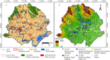
图1
江汉平原的主要土地覆盖类型(a)及采样点(b) a:数据来源于2017年的FROM-GLC土地覆盖数据;b:数据来自NASA SRTM Digital Elevation 地理高程数据。A-E为5种典型种植模式的验证区"

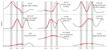
图2
耕地物候信息图谱"

图3
信息重映射规则"
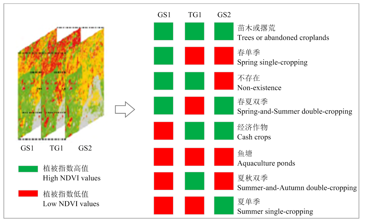
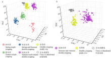
图4
在不同物候特征组合上的三维散点图 a:不同种植模式和苗木或撂荒在GS1, TG1和GS2上的散点图;b:夏秋双季,双季稻和苗木或撂荒在GS2, TG2和GS3上的散点图"

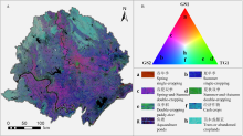
图5
江汉平原种植模式谱 A:3个物候期假彩色合成影像(GS1-TG1-GS2);B:三角形RGB彩色空间"

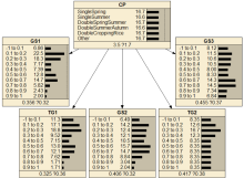
图6
种植模式提取的贝叶斯网络模型 CP:表示种植模式节点。SingleSpring:春单季;SingleSummer:夏单季;DoubleSpringSummer:春夏双季;DoubleSummerAutumn:夏秋双季;DoubleCroppingRice:双季稻。GS1、TG1、GS2、TG2和GS3分别表示关键物候期特征"

表1
子节点的概率图谱"
| GS1 | TG1 | GS2 | TG2 | GS3 | |
|---|---|---|---|---|---|
| 春单季 Spring single-cropping | | | | ||
| 夏单季 Summer single-cropping | | | | ||
| 双季稻 Double-cropping paddy-rice | | | | | |
| 春夏双季 Spring-and-Summer double-cropping | | | | ||
| 夏秋双季 Summer-and-Autumn double-cropping | | | | |
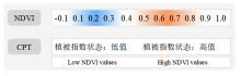
图7
植被指数状态的知识概率编码示意图"
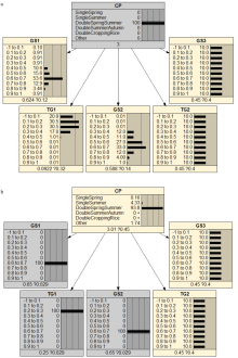
图8
贝叶斯网络的正向推理和反向推理 a:正向推理,当指定父节点为“春夏双季”时,概率传递到子节点,GS1-TG1-GS2呈现为“高-低-高”的组合特点。由于TG2和GS3节点只对双季稻有效,故此时概率分布无变化;b:反向推理,给定GS1-TG1-GS2的组合为“高-低-高”时,概率传递到父节点,预测种植模式为“春夏双季”的概率最高,达到93.8%"

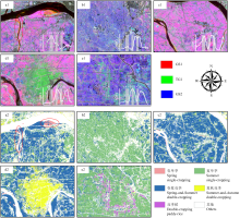
图9
验证区物候特征假彩色合成影像与种植模式提取结果的对比 a-e与验证区A-E一一对应;图a1-e1为3个物候特征的假彩色合成影像;图a2-e2为种植模式的提取结果"

表2
2017年种植模式提取结果的精度评价"
| 类型 Type | 春单季 Spring single-cropping | 夏单季 Summer single-cropping | 春夏双季 Spring-and-Summer double-cropping | 双季稻 Double-cropping paddy-rice | 夏秋双季 Summer-and-Autumn double-cropping | 其他 Others | 总计 Total | 用户精度 User’s accuracy (%) |
|---|---|---|---|---|---|---|---|---|
| 春单季 Spring single-cropping | 47 | 1 | 1 | 0 | 0 | 1 | 50 | 94.00 |
| 夏单季 Summer single-cropping | 0 | 190 | 1 | 6 | 1 | 11 | 209 | 90.91 |
| 春夏双季 Spring-and-Summer double-cropping | 3 | 13 | 244 | 0 | 0 | 0 | 260 | 93.85 |
| 双季稻 Double-cropping paddy-rice | 0 | 0 | 0 | 84 | 2 | 0 | 86 | 97.67 |
| 夏秋双季 Summer-and-Autumn double-cropping | 0 | 0 | 0 | 7 | 73 | 2 | 82 | 89.02 |
| 其他 Others | 1 | 24 | 10 | 4 | 2 | 164 | 205 | 80.00 |
| 总计 Total | 51 | 228 | 256 | 101 | 78 | 178 | 892 | |
| 生产者精度 Producer’s accuracy (%) | 92.16 | 83.33 | 95.31 | 83.17 | 93.59 | 92.13 | OA = 0.899 Kappa=0.872 |
表3
2018年种植模式提取结果的精度评价"
| 类型 Type | 春单季 Spring single-cropping | 夏单季 Summer single-cropping | 春夏双季 Spring-and-Summer double-cropping | 双季稻 Double-cropping paddy-rice | 夏秋双季 Summer-and-Autumn double-cropping | 其他 Others | 总计 Total | 用户精度 User’s accuracy (%) |
|---|---|---|---|---|---|---|---|---|
| 春单季 Spring single-cropping | 45 | 0 | 0 | 0 | 0 | 0 | 45 | 100.00 |
| 夏单季 Summer single-cropping | 0 | 197 | 3 | 2 | 0 | 12 | 214 | 92.06 |
| 春夏双季 Spring-and-Summer double-cropping | 3 | 1 | 235 | 0 | 1 | 3 | 243 | 96.71 |
| 双季稻 Double-cropping paddy-rice | 0 | 0 | 0 | 85 | 0 | 0 | 85 | 100.00 |
| 夏秋双季 Summer-and-Autumn double-cropping | 0 | 0 | 0 | 1 | 123 | 3 | 127 | 96.85 |
| 其他 Others | 4 | 4 | 0 | 14 | 7 | 143 | 172 | 83.14 |
| 总计 Total | 52 | 202 | 238 | 102 | 131 | 161 | 886 | |
| 生产者精度 Producer’s accuracy (%) | 86.54 | 97.52 | 98.74 | 83.33 | 93.89 | 88.82 | OA = 0.935 Kappa=0.918 |
表4
2019年种植模式提取结果的精度评价"
| 类型 Type | 春单季 Spring single-cropping | 夏单季 Summer single-cropping | 春夏双季 Spring-and-Summer double-cropping | 双季稻 Double-cropping paddy-rice | 夏秋双季 Summer-and-Autumn double-cropping | 其他 Others | 总计 Total | 用户精度 User’s accuracy (%) |
|---|---|---|---|---|---|---|---|---|
| 春单季 Spring single-cropping | 41 | 0 | 1 | 0 | 0 | 0 | 42 | 97.62 |
| 夏单季 Summer single-cropping | 0 | 402 | 6 | 1 | 0 | 14 | 423 | 95.04 |
| 春夏双季 Spring-and-Summer double-cropping | 1 | 3 | 498 | 0 | 1 | 0 | 503 | 99.01 |
| 双季稻 Double-cropping paddy-rice | 0 | 0 | 0 | 87 | 0 | 1 | 88 | 98.86 |
| 夏秋双季 Summer-and-Autumn double-cropping | 0 | 0 | 0 | 1 | 120 | 5 | 126 | 95.24 |
| 其他 Others | 0 | 9 | 2 | 7 | 9 | 152 | 179 | 84.92 |
| 总计 Total | 42 | 414 | 507 | 96 | 130 | 172 | 1361 | |
| 生产者精度 Producer’s accuracy (%) | 97.62 | 97.10 | 98.22 | 90.63 | 92.31 | 88.37 | OA = 0.955 Kappa=0.939 |
表5
2020年种植模式提取结果的精度评价"
| 类型 Type | 春单季 Spring single-cropping | 夏单季 Summer single-cropping | 春夏双季 Spring-and-Summer double-cropping | 双季稻 Double-cropping paddy-rice | 夏秋双季 Summer-and-Autumn double-cropping | 其他 Others | 总计 Total | 用户精度 User’s accuracy (%) |
|---|---|---|---|---|---|---|---|---|
| 春单季 Spring single-cropping | 67 | 0 | 10 | 0 | 0 | 2 | 79 | 84.81 |
| 夏单季 Summer single-cropping | 0 | 329 | 2 | 9 | 0 | 3 | 343 | 95.92 |
| 春夏双季 Spring-and-Summer double-cropping | 0 | 3 | 424 | 0 | 0 | 1 | 428 | 99.07 |
| 双季稻 Double-cropping paddy-rice | 0 | 0 | 0 | 98 | 0 | 0 | 98 | 100.00 |
| 夏秋双季 Summer-and-Autumn double-cropping | 1 | 0 | 1 | 0 | 164 | 4 | 170 | 96.47 |
| 其他 Others | 1 | 9 | 11 | 5 | 7 | 174 | 207 | 84.06 |
| 总计 Total | 69 | 341 | 448 | 112 | 171 | 184 | 1325 | |
| 生产者精度 Producer’s accuracy (%) | 97.10 | 96.48 | 94.64 | 87.50 | 95.91 | 94.57 | OA = 0.948 Kappa=0.933 |
表6
2021年种植模式提取结果的精度评价"
| 类型 Type | 春单季 Spring single-cropping | 夏单季 Summer single-cropping | 春夏双季 Spring-and-Summer double-cropping | 双季稻 Double-cropping paddy-rice | 夏秋双季 Summer-and-Autumn double-cropping | 其他 Others | 总计 Total | 用户精度 User’s accuracy (%) |
|---|---|---|---|---|---|---|---|---|
| 春单季 Spring single-cropping | 51 | 0 | 3 | 0 | 0 | 1 | 55 | 92.73 |
| 夏单季 Summer single-cropping | 0 | 431 | 47 | 1 | 8 | 25 | 512 | 84.18 |
| 春夏双季 Spring-and-Summer double-cropping | 1 | 3 | 611 | 0 | 1 | 11 | 627 | 97.45 |
| 双季稻 Double-cropping paddy-rice | 0 | 0 | 1 | 85 | 12 | 2 | 100 | 85.00 |
| 夏秋双季 Summer-and-Autumn double-cropping | 0 | 1 | 3 | 2 | 199 | 7 | 212 | 93.87 |
| 其他 Others | 2 | 30 | 18 | 15 | 13 | 205 | 283 | 72.44 |
| 总计 Total | 54 | 465 | 683 | 103 | 233 | 251 | 1789 | |
| 生产者精度 Producer’s accuracy (%) | 94.44 | 92.69 | 89.46 | 82.52 | 85.41 | 81.67 | OA = 0.884 Kappa=0.846 |
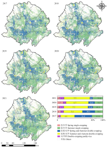
图10
江汉平原地区2017-2021年种植模式的空间分布及各种植模式的面积占比"

| [1] |
黄国勤. 中国南方耕作制度. 北京: 中国农业出版社, 1997.
|
|
|
|
| [2] |
doi: 10.3390/s17112622 |
| [3] |
李怡, 方斌, 李裕瑞, 璩路路, 李冬杰. 城镇化进程中耕地多功能权衡/协同关系演变及其驱动机制. 农业工程学报, 2022, 38(8): 244-254.
|
|
|
|
| [4] |
李欣宇, 方斌, 李怡, 李冬杰, 何莎莎. 中国粮耕价值比与种植结构时空耦合演化及分区调控. 地理学报, 2022, 77(11): 2721-2737.
doi: 10.11821/dlxb202211003 |
|
doi: 10.11821/dlxb202211003 |
|
| [5] |
吴郁玲, 张佩, 于亿亿, 谢锐莹. 粮食安全视角下中国耕地“非粮化”研究进展与展望. 中国土地科学, 2021, 35(9): 116-124.
|
|
|
|
| [6] |
|
| [7] |
doi: 10.3390/rs10040491 |
| [8] |
|
| [9] |
刘文斌, 陶建斌, 徐猛, 陈瑞卿, 郭洋. 基于人工神经网络多源数据融合的子像元冬油菜提取: 以两湖平原为例. 自然资源学报, 2019, 34(5): 1079-1092.
doi: 10.31497/zrzyxb.20190514 |
|
doi: 10.31497/zrzyxb.20190514 |
|
| [10] |
杨靖雅, 胡琼, 魏浩东, 蔡志文, 张馨予, 宋茜, 徐保东.基于Sentinel-1/2数据的中国南方单双季稻识别结果一致性分析. 中国农业科学, 2022, 55(16): 3093-3109. doi: 10.3864/j.issn.0578-1752. 2022.16.003.
|
|
|
|
| [11] |
doi: 10.1016/j.rse.2021.112365 |
| [12] |
doi: 10.1038/s41597-021-00827-9 |
| [13] |
doi: 10.1016/S2095-3119(20)63329-9 |
| [14] |
doi: 10.3390/rs14081809 |
| [15] |
doi: 10.1016/j.rse.2021.112831 |
| [16] |
doi: 10.1038/s41597-022-01589-8 |
| [17] |
doi: 10.1007/s11356-021-15387-z |
| [18] |
doi: 10.1088/1748-9326/aaf9c7 |
| [19] |
doi: 10.1016/j.rse.2019.111624 |
| [20] |
doi: 10.1038/s41597-021-01065-9 pmid: 34711845 |
| [21] |
doi: 10.1007/s11442-015-1234-3 |
| [22] |
李宇, 邱炳文, 何玉花, 陈功, 叶智燕. 基于MODIS数据的2001-2018年中国耕地复种指数反演研究. 地理科学进展, 2020, 39(11): 1874-1883.
doi: 10.18306/dlkxjz.2020.11.008 |
|
|
|
| [23] |
doi: 10.1088/1748-9326/11/2/024015 |
| [24] |
doi: 10.5194/isprs-annals-IV-3-45-2018 |
| [25] |
冀正欣, 王秀丽, 李玲, 关小克, 蔚霖, 许月卿. 南阳盆地区耕地利用效率演变及其影响因素. 自然资源学报, 2021, 36(3): 688-701.
doi: 10.31497/zrzyxb.20210312 |
|
doi: 10.31497/zrzyxb.20210312 |
|
| [26] |
陈述彭. 地学信息图谱刍议. 地理研究, 1998, 17(增刊): 5-8.
|
|
|
|
| [27] |
杨存建. 地学信息图谱思想与实践探索. 地球信息科学学报, 2020, 22(4): 697-704.
doi: 10.12082/dqxxkx.2020.200173 |
|
|
|
| [28] |
唐常春, 李亚平. 多中心城市群土地利用/覆被变化地学信息图谱研究: 以长株潭城市群为例. 地理研究, 2020, 39(11): 2626-2641.
doi: 10.11821/dlyj020200207 |
|
|
|
| [29] |
张韵, 彭建东, 王晶晶, 杨红. 基于地学信息图谱的江汉平原土地利用时空变化分析. 水土保持研究, 2020, 27(4): 85-92, 2.
|
|
|
|
| [30] |
刘卫东. 江汉平原土地类型与综合自然区划. 地理学报, 1994, 49(1): 73-83.
doi: 10.11821/xb199401009 |
|
doi: 10.11821/xb199401009 |
| [1] | 蔡倩,孙占祥,郑家明,王文斌,白伟,冯良山,杨宁,向午燕,张哲,冯晨. 辽西半干旱区玉米大豆间作模式对作物干物质积累分配、产量及土地生产力的影响[J]. 中国农业科学, 2021, 54(5): 909-920. |
| [2] | 周宝元, 马玮, 孙雪芳, 高卓晗, 丁在松, 李从锋, 赵明. 播/收期对冬小麦-夏玉米一年两熟模式周年 气候资源分配与利用特征的影响[J]. 中国农业科学, 2019, 52(9): 1501-1517. |
| [3] | 洪永胜,于雷,朱亚星,李思缔,郭力,刘家胜,聂艳,周勇. 利用OSC算法消除土壤含水量变化对Vis-NIR光谱估算有机质的影响[J]. 中国农业科学, 2017, 50(19): 3766-3777. |
| [4] | 孙新素,龙致炜,宋广鹏,陈长青. 气候变化对黄淮海地区夏玉米-冬小麦种植模式和产量的影响[J]. 中国农业科学, 2017, 50(13): 2476-2487. |
| [5] | 杨军香,王合亮,焦洪超,林海. 不同种植模式下的土地适宜载畜量[J]. 中国农业科学, 2016, 49(2): 339-347. |
| [6] | 王小燕,赵晓宇,陈恢富,王晓玲,熊勤学. 江汉平原小麦孕穗期空气相对湿度升高的产量效应[J]. 中国农业科学, 2014, 47(19): 3769-3779. |
| [7] | 汤文光,肖小平,唐海明,杨光立. 不同种植模式对南方丘陵旱地土壤水分利用与作物周年生产力的影响[J]. 中国农业科学, 2014, 47(18): 3606-3617. |
| [8] | 汤秋香, 刘宏斌, 雷宝坤, 翟丽梅, 胡万里, 罗新华, 张继宗, 任天志. 洱海北部地区环境友好型种植模式筛选[J]. 中国农业科学, 2012, 45(12): 2375-2383. |
| [9] | 聂胜委,陈源泉,隋鹏,高旺盛,黄坚雄,李媛媛,熊杰,史学朋,吴雪梅,孙自广 . 玉米与不同植物间作对田间氨挥发的影响 [J]. 中国农业科学, 2011, 44(3): 634-640 . |
| [10] | 房 辉,周江鸿,王云月,周惠萍,何霞红,孙 雁,杨黎华,朱有勇. 优化水稻群体种植模式与稻瘟病控制研究[J]. 中国农业科学, 2007, 40(5): 916-924 . |
| [11] | 李军,邵明安,王立祥. 黄土高原典型地区种植模式产量效应模拟与效益评价研究[J]. 中国农业科学, 2003, 36(12): 1599-1603 . |
|
||