


中国农业科学 ›› 2020, Vol. 53 ›› Issue (9): 1830-1844.doi: 10.3864/j.issn.0578-1752.2020.09.011
乔磊1,张吴平2( ),黄明镜3,王国芳1,任健1
收稿日期:2019-11-14
接受日期:2020-02-13
出版日期:2020-05-01
发布日期:2020-05-13
通讯作者:
张吴平
作者简介:乔磊,E-mail:qiaolei1995@126.com。
基金资助:
Lei QIAO1,WuPing ZHANG2(),MingJing HUANG3,GuoFang WANG1,Jian REN1
Received:2019-11-14
Accepted:2020-02-13
Online:2020-05-01
Published:2020-05-13
Contact:
WuPing ZHANG
摘要:
【目的】空间预测是一种获得有机质空间局部细节的重要方法,其准确性对于农田合理管理有着重要意义。本研究通过对比不同的土壤有机质空间制图方法以获得更优的预测精度,在预测的同时揭示环境协变量的空间非平稳性特征及不同环境协变量关系的空间尺度。【方法】选取晋中盆地的7个乡镇作为研究区,对比普通克里金(OK)、回归克里金(RK)、地理加权回归克里金(GWRK)和多重尺度地理加权回归克里金(MGWRK)4种不同方法对土壤有机质的预测能力和效果,并探究影响因子在空间分布中对有机质的影响效应变化和这种影响效应的空间尺度。MGWRK是一种多重尺度地理加权回归(MGWR)与普通克里金方法相结合的方法。【结果】选取坡向、坡度、年均降水量、年平均温度、海拔、植被年总初级生产力、年蒸散量、地形湿度指数、平面曲率、汇流动力指数、地形指数、地形粗糙指数、年平均NDVI为环境协变量参与建模,在多元线性回归建模中,模型统计学意义显著,这表明模型具备统计学意义。从Radius指数来看,各模型模拟效果由好到差依次为RK、OK、GWRK、MGWRK;从制图效果来看,MGWRK与GWRK制图效果相当,从有机质的空间预测图可以看出,土壤有机质在研究区呈现东西两侧偏低、中部偏高的空间格局,其中汾河以东、昌源河流经区域土壤有机质普遍偏高。坡向、年均降水量、年平均温度、海拔、地形指数、年平均NDVI对研究区东部有机质的影响强于西部,而坡度、植被年总初级生产力、年蒸散量、平面曲率、汇流动力指数、地形粗糙指数则表现出截然相反的空间非平稳性特征,地形湿度指数对有机质的影响则体现为北部强南部弱。【结论】MGWRK方法的空间预测精度分别达到了RK方法的69%、OK方法的71.74%、GWRK方法的71.17%。MGWRK在空间非平稳性特征的解释能力和空间可视化表现良好,为有机质的预测和空间非平稳性特征的描述提供方法借鉴。
乔磊,张吴平,黄明镜,王国芳,任健. 基于MGWRK的土壤有机质制图及驱动因素研究[J]. 中国农业科学, 2020, 53(9): 1830-1844.
Lei QIAO,WuPing ZHANG,MingJing HUANG,GuoFang WANG,Jian REN. Mapping of Soil Organic Matter and Its Driving Factors Study Based on MGWRK[J]. Scientia Agricultura Sinica, 2020, 53(9): 1830-1844.
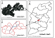
图1
研究区概况及样点分布"

表1
环境协变量数据列表"
| 数据类型 Data type | 指标 Index |
|---|---|
| 地形因子数据 Terrain data | 坡向Aspect |
| 坡度 Slope | |
| 海拔 Height | |
| 地形湿度指数 Topographic wetness index, TWI | |
| 平面曲率 Plan curvature, PC | |
| 汇流动力指数 Stream power index, SPI | |
| 地形指数 Terrain position index, TPI | |
| 地形粗糙指数 Terrain ruggedness index, TRI | |
| 气象数据 Meteorological data | 年平均降水Annual mean precipitation, PRE |
| 年平均温度 Annual mean temperature, TEM | |
| 遥感数据 Remote sensing data | 年植被总生产量GPP (From MOD17A2) |
| 年蒸散量 ET (From MOD16A2) | |
| 年平均NDVI (来自MOD13A1,使用最大合成法求得) Annual mean NDVI (Data from MOD13A1, obtained by Maximum Value Composites method) |
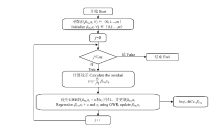
图2
MGWR模型的向后拟合(Back-fitting)算法[27]"

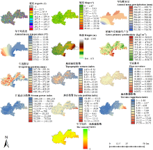
图3
环境协变量空间分布坡向以正北为0°,顺时针计数,-1为平地 Aspect direction is defined as zero degrees due north, clockwise count, -1 is flat"

表2
模型多重共线性检验"
| 指标Index | 容差 Tolerance | VIF |
|---|---|---|
| 坡向Aspects (°) | 0.993 | 1.007 |
| 坡度Slope (°) | 0.548 | 1.824 |
| 年均降水量Annual mean precipitation (mm) | 0.514 | 1.944 |
| 年平均温度Annual mean temperature (℃) | 0.417 | 2.400 |
| 海拔Height (m) | 0.670 | 1.493 |
| 植被年总初级生产力Gross primary productivity (kgC·m-2) | 0.216 | 4.636 |
| 年蒸散量Evapotranspiration (mm) | 0.194 | 5.168 |
| 地形湿度指数 Topographic wetness index | 0.652 | 1.534 |
| 平面曲率Plan curvature | 0.928 | 1.078 |
| 汇流动力指数 Stream power index | 0.980 | 1.021 |
| 地形指数 Terrain position index | 0.730 | 1.369 |
| 地形粗糙指数 Terrain ruggedness index | 0.548 | 1.824 |
| 年平均归一化植被指数 The annual NDVI | 0.893 | 1.120 |
表3
土壤有机质及环境协变量描述性统计"
| 指标 Index | 最小值 Minimum | 最大值 Maximum | 平均值 Mean | 标准差 Standard deviation | 方差 Variance | 变异系数 Coefficient of variation (%) |
|---|---|---|---|---|---|---|
| 有机质Soil organic matter (g·kg-1) | 2.10 | 33.00 | 13.91 | 5.01 | 25.09 | 36.00 |
| 坡向Aspects (°) | -1.00 | 359.12 | 180.32 | 106.64 | 11373.13 | 59.14 |
| 坡度Slope (°) | 0.00 | 33.37 | 6.84 | 4.60 | 21.20 | 67.36 |
| 年均降水量 Annual mean precipitation (mm) | 499.01 | 511.01 | 503.72 | 2.00 | 3.98 | 0.40 |
| 年平均温度 Annual mean temperature (℃) | 12.25 | 15.20 | 13.37 | 0.73 | 0.53 | 5.45 |
| 海拔Height (m) | 690.00 | 927.00 | 744.04 | 22.77 | 518.46 | 3.06 |
| 植被年总初级生产力 Gross primary productivity (kgC·m-2) | 270.28 | 817.96 | 557.30 | 68.57 | 4702.51 | 12.30 |
| 年蒸散量Evapotranspiration (mm) | 248.43 | 461.20 | 358.95 | 37.47 | 1403.98 | 10.44 |
| 地形湿度指数 Topographic wetness index | 0.00 | 19.39 | 9.61 | 3.14 | 9.86 | 32.67 |
| 平面曲率 Plan curvature | -0.01 | 0.01 | 0.00 | 0.00 | 0.00 | 1281.06 |
| 汇流动力指数 Stream power index | -167350.00 | 11730.90 | -3405.69 | 18999.56 | 360983218.24 | -557.88 |
| 地形指数 Terrain position index | -21.49 | 21.78 | -0.47 | 4.88 | 23.78 | -1040.39 |
| 地形粗糙指数 Terrain ruggedness index | 0.00 | 18.72 | 3.81 | 2.25 | 5.05 | 58.96 |
| 年平均归一化植被指数 The annual NDVI | 0.00 | 2.80 | 0.71 | 0.19 | 0.04 | 26.44 |

图4
半变异函数图"
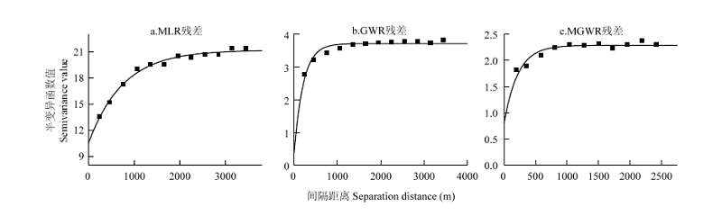
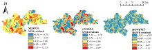
图5
各模型残差图"

表4
各模型结果空间变异"
| 拟合模型 Fitting model | 块金值 Nugget | 基台值 Sill | 变程 Range (m) | 块金系数 Nugget/Sill (%) | |
|---|---|---|---|---|---|
| MLR残差 MLR residuals | E | 10.59 | 21.20 | 2265 | 49.95 |
| GWR残差 GWR residuals | E | 0.38 | 3.72 | 636 | 10.22 |
| MGWR残差MGWR residuals | E | 0.81 | 2.29 | 657 | 35.37 |
表5
各模型评价指标"
| 模型 Model | RMSE | MAE | ME | R2 | Radius |
|---|---|---|---|---|---|
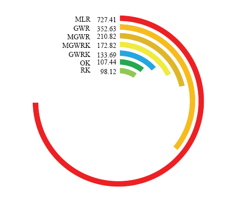
| OK | 2.8553 | 2.1009 | 0.0009 | 0.6984 | 107.4383 |
| RK | 2.7613 | 2.0396 | -0.0001 | 0.7207 | 98.1195 |
| MGWRK | 3.5430 | 2.6292 | 0.0036 | 0.5010 | 172.8181 |
| GWRK | 3.0622 | 2.2402 | 0.0978 | 0.6492 | 133.6925 |
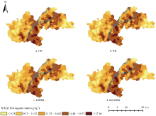
图6
各模型土壤制图结果 该图制图的空间分辨率为30 m The mapping spatial resolution is 30 m"

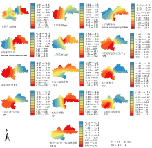
图7
土壤有机质影响因子标准化回归系数分布"
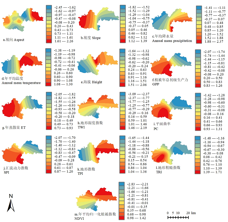
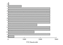
图8
MGMR与GWR模型带宽对比 a:坡向;b:坡度;c:年均降水量;d:年平均温度;e:海拔;f:植被年总初级生产力;g:年蒸散量;h:TPI;i:平面曲率;j:SPI;k:TPI;l:TRI;m:NDVI;n:截距项;o:GWR模型"

表6
其他模型评价"
| 模型 Model | RMSE | MAE | ME | R2 | Radius |
|---|---|---|---|---|---|
| MLR | 4.5402 | 3.4510 | 0.0000 | 0.1782 | 727.4052 |
| GWR | 3.9863 | 2.9921 | 0.0375 | 0.3731 | 352.6252 |
| MGWR | 3.5959 | 2.6806 | -0.0005 | 0.4916 | 210.8228 |

图9
不同模型的Radius指数弧形图"
| [1] | 黄昌勇, 徐建明 . 土壤学. 北京: 中国农业出版社, 2010. |
| HUANG C Y, XU J M . Soil Science. Beijing: China Agriculture Press, 2010. (in Chinese) | |
| [2] | 银敏华, 李援农, 李昊, Yang Yang, 徐袁博, 张天乐 . 垄覆黑膜沟覆秸秆促进夏玉米生长及养分吸收. 农业工程学报, 2015,31(22):122-130. |
| YIN M H, LI Y N, LI H, YANG Y, XU Y B, ZHANG T L . Ridge-furrow planting with black film mulching over ridge and corn straw mulching over furrow enhancing summer maize’s growth and nutrient absorption. Transactions of the Chinese Society of Agricultural Engineering, 2015,31(22):122-130. (in Chinese) | |
| [3] | 周伟, 王文杰, 何兴元, 张波, 肖路, 王琼, 吕海亮, 魏晨辉 . 哈尔滨城市绿地土壤肥力及其空间特征. 林业科学, 2018,54(9):9-17. |
| ZHOU W, WANG W, HE X Y, ZHANG B, XIAO L, WANG Q, LV H L, WEI C H . Soil fertility and spatial variability of urban green land in Harbin. Scientia Silvae Sinicae, 2018,54(9):9-17. DOI: 10.11707/ j.1001-7488.20180902. (in Chinese) | |
| [4] | 庞蕊, 刘敏, 李美玲, 徐兴良 . 土壤碳排放组分区分的研究进展. 生态学杂志, 2017,36(8):2327-2335. |
| PANG R, LIU M, LI M L, XU X L . Advances in research on the separation of soil carbon emissions. Chinese Journal of Ecology, 2017,36(8):2327-2335. DOI: 10.13292/j.1000-4890.201708.007. (in Chinese) | |
| [5] |
吴春生, 刘高焕, 刘庆生, 黄翀, 张韵婕, 管续栋 . 蒙古高原中北部土壤有机质空间分布研究. 资源科学, 2016,38(5):994-1002.
doi: 10.18402/resci.2016.05.18 |
|
WU C S, LIU G H, LIU Q S, HUANG C, ZHANG Y J, GUAN X D . The spatial distribution of soil organic matter on the north-central Mongolian Plateau. Resources Science, 2016,38(5):994-1002. DOI: 10.18402/resci.2016.05.18. (in Chinese)
doi: 10.18402/resci.2016.05.18 |
|
| [6] | 陈琳, 任春颖, 王宗明, 张柏 . 基于克里金插值的耕地表层土壤有机质空间预测. 干旱区研究, 2017,34(4):798-805. |
| CHEN L, REN C Y, WANG Z M, ZHANG B . Prediction of spatial distribution of topsoil organic matter content in cultivated land using Kriging methods. Arid Zone Research, 2017,34(4):798-805. DOI: 10.13866/j.azr.2017.04.12. (in Chinese) | |
| [7] |
ZENG C Y, YANG L, ZHU A X, DAVID G R, LIU J, LIU J Z, QIN C Z, WANG D S . Mapping soil organic matter concentration at different scales using a mixed geographically weighted regression method. Geoderma, 2016,281:69-82.
doi: 10.1016/j.geoderma.2016.06.033 |
| [8] | 王合玲, 张辉国, 吕光辉 . 艾比湖流域土壤有机质与土壤因子响应关系的空间非平稳性分析. 水土保持研究, 2016,23(2):224-228,357,358. |
| WANG H L, ZHANG H G, LV G H . Analysis of spatial non- stationary relationships between soil organic matter and soil factors in Ebinur Lake Basin. Researcher of Soil and Water Conservation, 2016,23(2):224-228,357,358. DOI: 10.13869/j.cnki. rswc.2016.02.042. (in Chinese) | |
| [9] | 马泉来, 高凤杰, 张志民, 单培明, 韩文文, 周军, 曲茉莉 . 我国东北黑土丘陵区小流域土壤有机质空间分布模拟. 环境科学研究, 2016,29(3):382-390. |
| MA Q L, GAO F J, ZHANG Z M, SHAN P M, HAN W W, ZHOU J, QU M L . Simulation of spatial distribution of soil organic matter in a mollisol watershed in Northeastern China. Research of Environmental Sciences, 2016,29(3):382-390. DOI: 10.13198/j.issn.1001-6929.2016. 03.09. (in Chinese) | |
| [10] | YE H C, HUANG W J, HUANG S Y, HUANG Y F, ZHANG S W, DONG Y Y, CHEN P F . Effects of different sampling densities on geographically weighted regression kriging for predicting soil organic carbon. Spatial Statistics, 2017,20:79-61. |
| [11] | 石淑芹, 曹祺文, 李正国, 许恒周 . 气候与社会经济因素对土壤有机质影响的空间异质性分析——以黑龙江省中部地区为例. 中国生态农业学报, 2014,22(9):1102-1112. |
| SHI S Q, CAO Q W, LI Z G, XU H Z . Influence of spatial heterogeneity of climatic and socio-economic factors on soil organic matter —A case study of the central Heilongjiang Province, China. Chinese Journal of Eco-Agriculture, 2014,22(9):1102-1112. DOI: 10.13930/j.cnki.cjea.140097. (in Chinese) | |
| [12] | 杜一尘, 李明泽, 范文义, 王斌 . 基于地理加权回归模型与林火遥感数据估算森林年龄. 林业科学, 2019,55(6):184-194. |
| DU Y C, LI M Z, FAN W Y, WANG B . Estimation of forest stand age based on gwr model and forest fire remote sensing data. Scientia Silvae Sinicae, 2019,55(6):184-194. DOI: 10.11707/j.1001-7488. 20190622. (in Chinese) | |
| [13] | 王海宾, 侯瑞萍, 郑冬梅, 高秀会, 夏朝宗, 彭道黎 . 基于地理加权回归模型的亚热带地区乔木林生物量估算. 农业机械学报, 2018,49(6):184-190. |
| WANG H B, HOU R P, ZHENG D M, GAO X H, XIA C Z, PENG D L . Biomass estimation of arbor forest in subtropical region based on geographically weighted regression model. Transactions of the Chinese Society of Agricultural Machinery, 2018,49(6):184-190. DOI: 10.6041/j.issn.1000-1298.201.06.021. (in Chinese) | |
| [14] | 亚森江·喀哈尔, 茹克亚·萨吾提, 尼加提·卡斯木, 尼格拉·塔什甫拉提, 张飞, 阿不都艾尼·阿不里, 师庆东 . 优化光谱指数的露天煤矿区土壤重金属含量估算. 光谱学与光谱分析, 2019,39(8):2486-2494. |
| YASENJIANG K, RUKEYA S, NIJAT K, NIGARA T, ZHANG F, ABDUGHENI A, SHI Q D . Estimation of heavy metal contents in soil around open pit coal mine area based on optimized spectral index. Spectroscopy and Spectral Analysis, 2019,39(8):2486-2494. DOI: 10.3964/j.issn.1000-0593(2019)08-2486-09. (in Chinese) | |
| [15] | 许珊, 邹滨, 宫俊霞 . 2001~2015年中国城镇化与PM_(2.5)浓度时空关联特征. 中国环境科学, 2019,39(2):469-477. |
| XU S, ZOU B, GONG J X . Analysis of the spatial-temporal association between urbanization and PM2.5 concentration during 2001~2015 period in Mainland China. China Environmental Science, 2019,39(2):469-477. DOI: 10.19674/j.cnki.issn1000-6923.2019.0057. (in Chinese) | |
| [16] |
XU C C, ZHAO J Y, LIU P . A geographically weighted regression approach to investigate the effects of traffic conditions and road characteristics on air pollutant emissions. Journal of Cleaner Production, 2019,239:118084.
doi: 10.1016/j.jclepro.2019.118084 |
| [17] |
王海军, 张彬, 刘耀林, 刘艳芳, 徐姗, 邓羽, 赵雲泰, 陈宇琛, 洪松 . 基于重心-GTWR模型的京津冀城市群城镇扩展格局与驱动力多维解析. 地理学报, 2018,73(6):1076-1092.
doi: 10.11821/dlxb201806007 |
|
WANG H J, ZHANG B, LIU Y L, LIU Y F, XU S, DENG Y, ZHAO Y T, CHEN Y C, HONG S . Multi-dimensional analysis of urban expansion patterns and their driving forces based on the center of gravity-GTWR model: A case study of the Beijing-Tianjin-Hebei urban agglomeration. Acta Geographica Sinica, 2018,73(6):1076-1092. DOI: 10.11821/dlxb201806007. (in Chinese)
doi: 10.11821/dlxb201806007 |
|
| [18] |
杨晴青, 刘倩, 尹莎, 张戬, 杨新军, 高岩辉 . 秦巴山区乡村交通环境脆弱性及影响因素——以陕西省洛南县为例. 地理学报, 2019,74(6):1236-1251.
doi: 10.11821/dlxb201906012 |
|
YANG Q Q, LIU Q, YIN S, ZHANG J, YANG X J, GAO Y H . Vulnerability and influencing factors of rural transportation environment in Qinling-Daba mountainous areas: A case study of Luonan county in Shaanxi province. Acta Geographica Sinica, 2019,74(6):1236-1251. DOI: 10.11821/dlxb201906012. (in Chinese)
doi: 10.11821/dlxb201906012 |
|
| [19] | 鲍士旦 . 土壤农化分析. 3版. 北京: 中国农业出版社, 2015. |
| BAO S D. Soil and Agrochemical Analysis. 3rd ed. Beijing: Chinese Agriculture Press, 2015. (in Chinese) | |
| [20] | 刘爱利, 王培法, 丁园圆 . 地统计学概论. 北京: 科学出版社, 2012. |
| LIU A L, WANG P F, DING Y Y. Introduction to Geostatistics. Beijing: Science Press, 2012. (in Chinese) | |
| [21] | WU Z H, WANG B Z, HUANG J L, AN Z H, JIANG P, CHEN Y Y, LIU Y F . Estimating soil organic carbon density in plains using landscape metric-based regression Kriging model. Soil & Tillage Research, 2019,195:104381. |
| [22] |
HENGL T, HEUVELINK G B M, ROSSITER D G . About regression- kriging: From equations to case studies. Computers and Geosciences, 2007,33(10):1301-1315.
doi: 10.1016/j.cageo.2007.05.001 |
| [23] |
SHEN Q S, WANG Y, WANG X R, LIU X, ZHANG X Y, ZHANG S L . Comparing interpolation methods to predict soil total phosphorus in the Mollisol area of Northeast China. Catena, 2019,174:59-72.
doi: 10.1016/j.catena.2018.10.052 |
| [24] |
杨顺华, 张海涛, 郭龙, 任艳 . 基于回归和地理加权回归Kriging的土壤有机质空间插值. 应用生态学报, 2015,26(6):1649-1656.
pmid: 26572015 |
|
YANG S H, ZHANG H T, GUO L, REN Y . Spatial interpolation of soil organic matter using regression Kriging and geographically weighted regression Kriging. Chinese Journal of Applied Ecology, 2015,26(6):1649-1656. DOI: 10.13287/j.1001-9332.20150331.023. (in Chinese)
pmid: 26572015 |
|
| [25] | 聂磊, 舒红, 刘艳 . 复杂地形地区月平均气温(混合)地理加权回归克里格插值. 武汉大学学报(信息科学版), 2018,43(10):1553-1559. |
| NIE L, SHU H, LIU Y . Interpolation of monthly average temperature by using (mixed) Geographically Weighted Regression Kriging in the complex terrain region. Geomatics and Information Science of Wuhan University, 2018,43(10):1553-1559. DOI: 10.13203/j.whugis20160433. (in Chinese) | |
| [26] | A. STEWART F, CHRIS B, MARTIN C . Geographically Weighted Regression: The Analysis of Spatially Varying Relationships. Wiley, 2002. |
| [27] |
A. STEWART F, YANG W B, KANG W . Multiscale Geographically Weighted Regression (MGWR). Annals of the American Association of Geographers, 2017,107(6):1247-1265.
doi: 10.1080/24694452.2017.1352480 |
| [28] | LI Z Q, TAYLOR O, STEWART F, KANG W, LEVI W, YU H C, LUO W . MGWR 1. 0 User Manual. Spatial Analysis Research Center (SPARC). [2019-11-1] https: //sgsup.asu.edu/sparc/mgwr. |
| [29] | YANG S H, LIU F, SONG X D, LU Y Y, LI D C, ZHAO Y G, ZHANG G L . Mapping topsoil electrical conductivity by a mixed geographically Weighted Regression Kriging: A case study in the Heihe River Basin, northwest China. Ecological Indicators, 2019,102:252-264. |
| [30] | 邱孟龙, 曹小曙, 周建, 冯小龙, 高兴川 . 基于GWR模型的渭北黄土旱塬粮食单产空间分异及其影响因子分析——以陕西彬县为例. 中国农业科学, 2019,52(2):273-284. |
| QIU M L, CAO X S, ZHOU J, FENG X L, GAO X C . Spatial differentiation and impact factors of grain yield per hectare in Weibei Plateau based on GWR Model: A case study of Binxian County, Shannxi. Scientia Agricultura Sinica, 2019,52(2):273-284. DOI: 10.3864/j.issn.0578-1752.2019.02.007. (in Chinese) | |
| [31] | 邹润彦, 周宏冀, 郭熙, 但承龙, 吕添贵, 李洪义 . 环鄱阳湖区农田土壤有机碳影响因素空间分布格局分析及制图研究. 长江流域资源与环境, 2019,28(5):1121-1131. |
| ZOU R Y, ZHOU H J, GUO X, DAN C L, LV T G, LI H Y . Spatial distribution and mapping of influencing factors of farmland soil organic carbon in the Poyang Lake Region. Resources and Environment in the Yangtze Basin, 2019,28(5):1121-1131. DOI: 10.11870/ cjlyzyyhj201905012. (in Chinese) | |
| [32] |
杨帆, 曾维忠, 张维康, 庄天慧 . 林农森林碳汇项目持续参与意愿及其影响因素. 林业科学, 2016,52(7):138-147.
doi: 10.11707/j.1001-7488.20160717 |
|
YANG F, ZENG W Z, ZHANG W K, ZHUANG T H . Foresters’ constant participation willingness and affecting factors in forest carbon sequestration project. Scientia Silvae Sinicae, 2016,52(7):138-147. DOI: 10.11707/j.1001-7488.20160717. (in Chinese)
doi: 10.11707/j.1001-7488.20160717 |
|
| [33] | 张吴平, 杨坚 . 食品试验设计与统计分析. 3版. 北京: 中国农业大学出版社, 2017. |
| ZHANG W P, YANG J. . Food Experimental Design and Statistical Analysis. 3rd ed. Beijing: China Agricultural University Press, 2017. (in Chinese) | |
| [34] | 郑新奇, 吕利娜 . 地统计学(现代空间统计学). 北京: 科学出版社, 2018. |
| ZHENG X Q, LV L N. Geostatistics (Modern Spatial Statistics). Beijing: Science Press, 2018. (in Chinese) | |
| [35] | 李哈滨, 王政权, 王庆成 . 空间异质性定量研究理论与方法. 应用生态学报, 1998(6):93-99. |
| LI H B, WANG Z Q, WANG Q C . Theory and methodology of spatial heterogeneity quantification. Chinese Journal of Applied Ecology, 1998(6):93-99. DOI: 10.13287/j.1001-9332.1998.0136. (in Chinese) | |
| [36] | 郑帅 . 温带森林土壤有机质分解对土壤含水量变化的响应[D]. 长春: 东北师范大学, 2019. |
| ZHENG S . Response of soil organic matter decomposition to soil water content change in temperate forests[D]. Changchun: Northeast Normal University, 2019. (in Chinese) | |
| [37] |
肖璐, 郎艺超, 夏浪, 楼昭涵, 孙楠, 黄李童, George Christakos . 基于多源数据的PM(2.5)浓度时空分布预测与制图. 环境科学, 2017,38(12):4913-4923.
doi: 10.13227/j.hjkx.201705122 pmid: 29964548 |
|
XIAO L, LANG Y C, XIA L, LOU Z H, SUN N, HUANG L T, GEORGE C . Space-time estimations and mapping of PM2.5 fine particulates based on multi-source data. Environmental Science, 2017,38(12):4913-4923. DOI: 10.13227/j.hjkx.201705122. (in Chinese)
doi: 10.13227/j.hjkx.201705122 pmid: 29964548 |
|
| [38] |
田瑞云, 王玉宽, 傅斌, 刘援 . 基于DEM的地形单元多样性指数及其算法. 地理科学进展, 2013,32(1):121-129. (in Chinese)
doi: 10.11820/dlkxjz.2013.01.013 |
|
TIAN R Y, WANG Y K, FU B, LIU Y . DEM-based topographic unit diversity index and its algorithm. Progress in Geography, 2013,32(1):121-129. DOI: 10.3724/SP.J.1033.2013.00121. (in Chinese)
doi: 10.11820/dlkxjz.2013.01.013 |
|
| [39] | RILEY S J, DEGLORIA S D, ELLIOT R . A terrain ruggedness index that quantifies topographic heterogeneity. Intermountain Journal of Sciences, 1999,5:1-4. |
| [1] | 张维理,傅伯杰,徐爱国,杨鹏,陈涛,张认连,史舟,吴文斌,李建兵,冀宏杰,刘峰,雷秋良,李兆君,冯瑶,李艳丽,徐用兵,裴玮. 中国土壤调查结果的地统计特征[J]. 中国农业科学, 2022, 55(13): 2572-2583. |
| [2] | 崔帅,刘烁然,王寅,夏晨真,焉莉,冯国忠,高强. 吉林省旱地土壤有效硫含量及其与土壤有机质和全氮的关系[J]. 中国农业科学, 2022, 55(12): 2372-2383. |
| [3] | 房蕊,于镇华,李彦生,谢志煌,刘俊杰,王光华,刘晓冰,陈渊,刘居东,张少庆,吴俊江,Stephen J HERBERT,金剑. 大气CO2浓度和温度升高对农田土壤碳库及微生物群落结构的影响[J]. 中国农业科学, 2021, 54(17): 3666-3679. |
| [4] | 张振华,丁建丽,王敬哲,葛翔宇,王瑾杰,田美玲,赵启东. 集成土壤-环境关系与机器学习的干旱区土壤属性数字制图[J]. 中国农业科学, 2020, 53(3): 563-573. |
| [5] | 李冬初,黄晶,马常宝,薛彦东,高菊生,王伯仁,张杨珠,柳开楼,韩天富,张会民. 中国稻田土壤有机质时空变化及其驱动因素[J]. 中国农业科学, 2020, 53(12): 2410-2422. |
| [6] | 姜赛平,张认连,张维理,徐爱国,张怀志,谢良商,冀宏杰. 近30年海南岛土壤有机质时空变异特征及成因分析[J]. 中国农业科学, 2019, 52(6): 1032-1044. |
| [7] | 刘琳,吉冰洁,李若楠,BATBAYARJavkhlan,张树兰,杨学云. 陕西关中冬小麦/夏玉米区土壤磷素特征[J]. 中国农业科学, 2019, 52(21): 3878-3889. |
| [8] | 姜桂英,张玉军,魏喜,张东旭,刘世亮,柳开楼,黄绍敏,申凤敏. 不同碳饱和水平下典型农田土壤有机质的红外光谱特征[J]. 中国农业科学, 2018, 51(16): 3117-3129. |
| [9] | 朱亚星,于雷,洪永胜,章涛,朱强,李思缔,郭力,刘家胜. 土壤有机质高光谱特征与波长变量优选方法[J]. 中国农业科学, 2017, 50(22): 4325-4337. |
| [10] | 洪永胜,于雷,朱亚星,李思缔,郭力,刘家胜,聂艳,周勇. 利用OSC算法消除土壤含水量变化对Vis-NIR光谱估算有机质的影响[J]. 中国农业科学, 2017, 50(19): 3766-3777. |
| [11] | 周国朋,曹卫东,白金顺,聂 军,徐昌旭,曾闹华,高嵩涓,王艳秋,志水胜好. 多年紫云英-双季稻下不同施肥水平对两类水稻土有机质及可溶性有机质的影响[J]. 中国农业科学, 2016, 49(21): 4096-4106. |
| [12] | 南 锋,朱洪芬,毕如田. 黄土高原煤矿区复垦农田土壤有机质含量的高光谱预测[J]. 中国农业科学, 2016, 49(11): 2126-2135. |
| [13] | 张福韬,乔云发,苗淑杰,韩晓增. 长期玉米连作下黑土各组分有机质化学结构特征[J]. 中国农业科学, 2016, 49(10): 1913-1924. |
| [14] | 吕薇,李军,岳志芳,陈宁宁,王淑兰. 轮耕对渭北旱塬麦田土壤有机质和全氮含量的影响[J]. 中国农业科学, 2015, 48(16): 3186-3200. |
| [15] | 霍颖,张杰,王美超,姚允聪. 梨园行间种草对土壤有机质和矿质元素变化及相互关系的影响[J]. 中国农业科学, 2011, 44(7): 1415-1424. |
|
||