


中国农业科学 ›› 2018, Vol. 51 ›› Issue (24): 4659-4676.doi: 10.3864/j.issn.0578-1752.2018.24.007
王飞1,2,3( ),杨胜天2,魏阳2,杨晓东2,3,丁建丽1,2,3()
收稿日期:2018-05-14
接受日期:2018-07-20
出版日期:2018-12-16
发布日期:2018-12-16
基金资助:
WANG Fei1,2,3(),YANG ShengTian2,WEI Yang2,YANG XiaoDong2,3,DING JianLi1,2,3()
Received:2018-05-14
Accepted:2018-07-20
Online:2018-12-16
Published:2018-12-16
摘要:
目的 试图通过优先在干旱区绿洲的子区构建模型以提高绿洲全局土壤盐度的预测精度。同时量化全局模型和子区模型之间精度的差异性和不确定性。方法 利用随机森林(Random Forest,RF)和随机梯度增进算法(Stochastic Gradient Treeboost,SGT)定量化上述不确定性,同时,对比本地尺度多个情景(景观)优先建立模型再合并预测值对于模拟全局土壤盐度的精度影响。基于驱动因子(土地利用和地貌),响应因子(Normalized Difference Vegetation Index, NDVI和土壤电导率,EC),研究设计了27个能够相对覆盖典型绿洲不同土壤盐度变异性的环境情景。结果 70.37%(19/27)的情景证明SGT的预测精度高于RF。单独建模的10个情景的预测精度高于全局模型下10个再分类情景(根据情景设定规则将全局模型预测值再分类)的精度。特别是,EC≤4 dS·m -1 和 2 dS·m -1< EC<16 dS·m -1两个情景应该单独进行建模预测。4个情景(两两合并)预测值合并后的精度高于全局模型再分类后的精度。需要指出的是,用于绿洲尺度子区情景构建的首选分割变量是EC,其次是地貌和土地利用。结论 研究推荐基于SGT在绿洲内部不同景观尺度上优先建模,再将各景观尺度的预测值进行合并,以提高绿洲土壤盐度的推理精度。
王飞,杨胜天,魏阳,杨晓东,丁建丽. 基于RF和SGT算法的子区优先建模对绿洲尺度 土壤盐度预测精度的影响[J]. 中国农业科学, 2018, 51(24): 4659-4676.
WANG Fei,YANG ShengTian,WEI Yang,YANG XiaoDong,DING JianLi. Influence of Sub-Region Priority Modeling Constructed by Random Forest and Stochastic Gradient Treeboost on the Accuracy of Soil Salinity Prediction in Oasis Scale[J]. Scientia Agricultura Sinica, 2018, 51(24): 4659-4676.
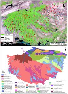
图1
渭干河-库车河流域景观地貌特征及绿洲采样点分布图"

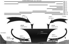
图2
绿洲-沙漠水热和能量交换示意及情景覆盖范围(修改自LI等[10])"

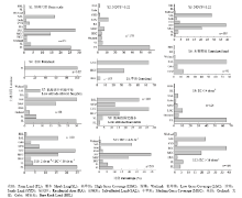
图3
12个情景的土地利用分布特征"

表1
基于Landsat OLI(30 m)和DEM(8个空间分辨率)衍生的环境变量"
| 变量组 Environment variable group | 指数 Index |
|---|---|
| 波段及其衍生变量 Band & derivatives | 全波段;缨帽变换(亮度(TC1),绿度(TC2),湿度(TC3),主成分分析(前三个波段) Bands;Tasseled Cap (brightness,TC1;Greenness,TC2; Wetness,TC3 ), Principal Component Analysis(PC1,PC2,PC3) |
| 植被指数 Vegetation indices | 归一化植被指数;土壤调节植被指数;增强植被指数;广义植被指数;冠层响应盐度指数[ Normalized Difference Vegetation Index, NDVI; Soil Adjusted Vegetation Index, SAVI; Enhanced Vegetation Index, EVI; Generalized Difference Vegetation Index, GDVI[ |
| 土壤相关指数 Soil-related indices | 盐度指数(Salinity Index, SIT)[ |
| DEM衍生因子 Dem derivatives | 河道相关:谷深(Valley Depth ,VD);与河网的垂直距离(Vertical Distance To Channel Network ,VDCN);水文学相关:坡长因子(LS-Factor, LSF);地形指数指数(Topographic Wetness Index, TWI);坡长(Slope Length, SL);通视度(Sky View Factor, SVF);地形位置指数(Topographic Position Index, TPI);多尺度谷底平整度(Multiresolution Index Of Valley Bottom Flatness(MRVBF And MRRTF)),坡高(Slope Height, SH),归一化高度(Normalized Height, NH),标准化高度(Standardized Height, STH),坡度中值位置Mid-Slope Position(MSP),地表纹理(Terrain Surface Texture, TEX),汇流累积量(Flow Accumulation, FA);形态:截面曲率(Cross-Section Curvature, CSC),纵向曲率(Longitudinal Curvature, LC),相对坡度位置(Relative Slope Position, RSP),流域坡度(Catchment Slope, CS)(SAGA Development Team, 2011) |
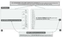
图4
独立情景建模与全样本建模下预测值根据情景重分类之间的精度对比方案"
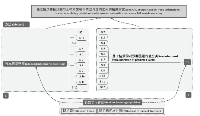
图5
情景预测值的合并对于绿洲尺度土壤盐度预测影响的对比方案"

图6
不同情景RF算法中mtry的最优值"
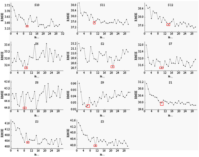
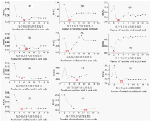
图7
不同情景下SGT算法中最大化节点(node)的最优值"
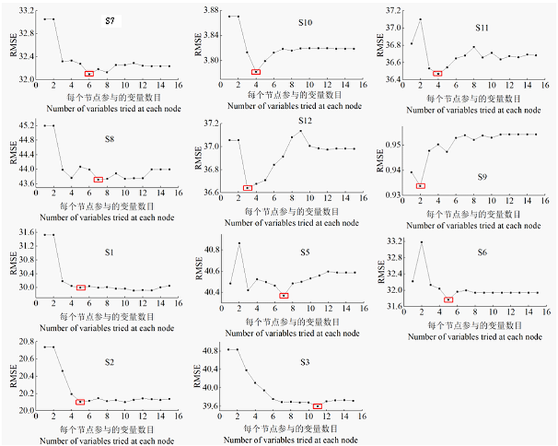
表2
12个情景的土壤电导率(dS·m-1)统计特征"
| 情景 Scenario | 最小值 Min | 最大值 Max | 平均值 Average | 变异系数 CV | Q25 | Q50 | Q75 |
|---|---|---|---|---|---|---|---|
| S1 | 0.14 | 184.5 | 31.32 | 1.29 | 1.42 | 13.11 | 48.00 |
| S2 | 0.14 | 128.50 | 11.25 | 2.02 | 0.42 | 1.50 | 9.90 |
| S3 | 0.15 | 184.50 | 47.14 | 0.95 | 11.84 | 26.00 | 79.95 |
| S4 | 0.15 | 103.9 | 5.57 | 2.97 | 0.38 | 0.90 | 3.36 |
| S5 | 0.14 | 184.50 | 47.33 | 0.95 | 11.59 | 26.00 | 88.00 |
| S6 | 0.23 | 150.50 | 34.38 | 1.10 | 6.76 | 17.33 | 60.90 |
| S7 | 0.27 | 184.50 | 50.40 | 0.92 | 11.77 | 35.40 | 78.82 |
| S8 | 0.14 | 147.40 | 28.20 | 1.37 | 1.34 | 10.69 | 33.89 |
| S9 | 0.14 | 3.99 | 0.99 | 0.95 | 0.33 | 0.55 | 1.41 |
| S10 | 2.01 | 15.92 | 8.47 | 0.50 | 4.54 | 7.97 | 12.04 |
| S11 | 4.06 | 184.50 | 46.43 | 0.90 | 13.11 | 25.70 | 75.60 |
| S12 | 16.28 | 184.5 | 64.10 | 0.63 | 24.85 | 61.10 | 94.15 |
表3
独立情景下(IS模式)基于随机森林和随机增进算法的精度验证"
| 情景 Scenario | 随机森林 Random Forest | 随机梯度增进算法 Stochastic Gradient Treeboost | ||||
|---|---|---|---|---|---|---|
| R2 | RMSE | RPD | R2 | RMSE | RPD | |
| S2 | 0.33** | 18.52 | 1.23 | 0.35** | 18.11 | 1.26 |
| S3 | 0.34** | 36.487 | 1.23 | 0.34** | 36.485 | 1.23 |
| S4 | 0.39** | 35.36 | 1.28 | 0.41** | 34.84 | 1.30 |
| S5 | 0.47** | 27.36 | 1.39 | 0.58** | 24.15 | 1.58 |
| S6 | 0.50** | 33.15 | 1.17 | 0.48** | 27.80 | 1.39 |
| S7 | 0.33** | 37.88 | 1.23 | 0.50** | 33.15 | 1.40 |
| S8 | 0.29** | 0.79 | 1.20 | 0.23** | 0.83 | 1.14 |
| S9 | 0.51** | 2.94 | 1.44 | 0.38** | 3.31 | 1.28 |
| S10 | 0.32** | 34.57 | 1.22 | 0.38** | 33.26 | 1.27 |
| S11 | 0.30** | 34.08 | 1.20 | 0.35** | 32.99 | 1.24 |
表4
RS模式基于随机森林和随机增进算法的精度验证(根据情景划定规则重分类)"
| 情景 Scenario | 随机森林 Random Forest | 随机梯度增进算法 Stochastic Gradient Treeboost | ||||
|---|---|---|---|---|---|---|
| R2 | RMSE | RPD | R2 | RMSE | RPD | |
| S1 | 0.46** | 29.65 | 1.37 | 0.48** | 29.17 | 1.39 |
| S2 | 0.30** | 19.20 | 1.18 | 0.44** | 16.97 | 1.34 |
| S3 | 0.38** | 35.50 | 1.27 | 0.37** | 35.71 | 1.26 |
| S4 | 0.35** | 36.46 | 1.24 | 0.34** | 36.67 | 1.24 |
| S5 | 0.51** | 27.94 | 1.36 | 0.54** | 26.06 | 1.46 |
| S6 | 0.46** | 28.42 | 1.36 | 0.50** | 27.31 | 1.42 |
| S7 | 0.39** | 36.78 | 1.26 | 0.36** | 37.09 | 1.25 |
| S8 | ns | 15.19 | 0.06 | ns | 18.52 | 0.05 |
| S9 | 0.20** | 21.68 | 0.20 | 0.18** | 21.68 | 0.20 |
| S10 | 0.37** | 33.73 | 1.25 | 0.39** | 27.17 | 1.27 |
| S11 | 0.28** | 37.88 | 1.08 | 0.31** | 37.12 | 1.10 |
表5
情景合并模式(CS模式与RSOSM模式)对土壤盐度预测的精度影响"
| 情景合并 Scenario combination | 随机森林 Random Forest | 随机梯度增进算法 Stochastic Gradient Treeboost | ||||
|---|---|---|---|---|---|---|
| R2 | RMSE | RPD | R2 | RMSE | RPD | |
| S2 & S 3 | 0.49** | 29.73 | 1.37 | 0.47** | 29.54 | 1.38 |
| S9 & S11 | 0.51** | 28.25 | 1.43 | 0.55** | 27.23 | 1.48 |
| S5 & S6 | 0.43** | 32.86 | 1.32 | 0.47** | 31.63 | 1.37 |
| S5 & S6 (RSOSM) | 0.40** | 33.77 | 1.29 | 0.40** | 33.47 | 1.30 |
| S7 & S8 | 0.43** | 32.25 | 1.32 | 0.51** | 30.01 | 1.43 |
| S7 & S8 (RSOSM) | 0.46** | 31.55 | 1.36 | 0.47** | 31.03 | 1.38 |

图8
不同情景下基于RF预测的残差与观测值的对比"
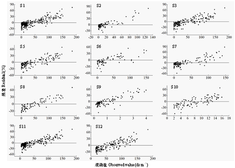
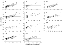
图9
不同情景下基于SGT预测的残差与观测值的对比"


图10
不同情景下基于1.2.6节中介绍的方法迭代获取的重要变量"
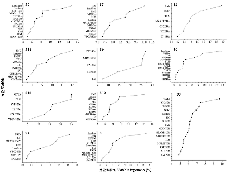
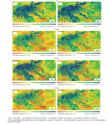
图11
基于RF和SGT预测的研究区土壤盐度空间分布特征。"

| [1] |
ALLBED A, KUMAR L, ALDAKHEEL Y Y . Assessing soil salinity using soil salinity and vegetation indices derived from IKONOS high-spatial resolution imageries: Applications in a date palm dominated region. Geoderma, 2014,230:1-8.
doi: 10.1016/j.geoderma.2014.03.025 |
| [2] |
SCUDIERO E, SKAGGS T H, CORWIN D L . Regional scale soil salinity evaluation using Landsat 7, western San Joaquin Valley, California, USA.Geoderma Regional, 2014(2/3):82-90.
doi: 10.1016/j.geodrs.2014.10.004 |
| [3] |
SCUDIERO E, SKAGGS T H, CORWIN D L . Regional-scale soil salinity assessment using Landsat ETM + canopy reflectance. Remote Sensing of Environment, 2015,169:335-343.
doi: 10.1016/j.rse.2015.08.026 |
| [4] |
TAGHIZADEH-MEHRJARDI R, MINASNY B, SARMADIAN F, MALONE B P . Digital mapping of soil salinity in Ardakan region, central Iran. Geoderma, 2014,213:15-28.
doi: 10.1016/j.geoderma.2013.07.020 |
| [5] |
WU W, MHAIMEED A S , AL-SHAFIE W M,ZIADAT F,DHEHIBI B,NANGIA V,PAUW E D.Mapping soil salinity changes using remote sensing in Central Iraq. Geoderma Regional, 2014(2/3):21-31.
doi: 10.1016/j.geodrs.2014.09.002 |
| [6] |
YAHIAOUI I, DOUAOUI A, QIANG Z, ZIANE A . Soil salinity prediction in the Lower Cheliff plain(Algeria) based on remote sensing and topographic feature analysis. Journal of Arid Land, 2015,7(6):794-805.
doi: 10.1007/s40333-015-0053-9 |
| [7] |
ZHANG T T, QI J G, GAO Y, OUYANG Z T, ZENG S L, ZHAO B . Detecting soil salinity with MODIS time series VI data. Ecological Indicators, 2015,52:480-489.
doi: 10.1016/j.ecolind.2015.01.004 |
| [8] |
ZHANG T-T, ZENG S-L, GAO Y, OUYANG Z-T, LI B, FANG C-M, ZHAO B . Using hyperspectral vegetation indices as a proxy to monitor soil salinity. Ecological Indicators, 2011,11(6):1552-1562.
doi: 10.1016/j.ecolind.2011.03.025 |
| [9] |
GARCíA M, OYONARTE C, VILLAGARCíA L, CONTRERAS S, DOMINGO F, PUIGDEFáBREGAS J . Monitoring land degradation risk using ASTER data: The non-evaporative fraction as an indicator of ecosystem function. Remote Sensing of Environment, 2008,112(9):3720-3736.
doi: 10.1016/j.rse.2008.05.011 |
| [10] |
LI X, YANG K, ZHOU Y. Progress in the study of oasis-desert interactions.Agricultural and Forest Meteorology 2016,230-231:1-7. DOI: 10.1016/j.agrformet.2016.08.022
doi: 10.1016/j.agrformet.2016.08.022 |
| [11] |
GONG L, RAN Q, HE G, TIYIP T . A soil quality assessment under different land use types in Keriya river basin, Southern Xinjiang, China. Soil and Tillage Research, 2015,146:223-229.
doi: 10.1016/j.still.2014.11.001 |
| [12] |
TUTEJA N K, BEALE G, DAWES W, VAZE J . Predicting the effects of landuse change on water and salt balance-a case study of a catchment affected by dryland salinity in NSW, Australia. Journal of Hydrology, 2003,283(1):67-90.
doi: 10.1016/S0022-1694(03)00236-1 |
| [13] |
WANG Y, LI Y . Land exploitation resulting in soil salinization in a desert-oasis ecotone. Catena, 2013,100:50-56.
doi: 10.1016/j.catena.2012.08.005 |
| [14] |
HENGL T , MENDES D J J, HEUVELINK G B, RUIPEREZ G M, KILIBARDA M, BLAGOTIĆ A, SHANGGUAN W, WRIGHT M N, GENG X, BAUERMARSCHALLINGER B. SoilGrids250m: Global gridded soil information based on machine learning. Plos One, 2017,12(2):e0169748.
doi: 10.1371/journal.pone.0169748 pmid: 5313206 |
| [15] |
SCHILLACI C, LOMBARDO L, SAIA S, FANTAPPIè M ,MäRKER M,ACUTIS M. Modelling the topsoil carbon stock of agricultural lands with the Stochastic Gradient Treeboost in a semi-arid Mediterranean region. Geoderma, 2017,286:35-45.
doi: 10.1016/j.geoderma.2016.10.019 |
| [16] | HASTIE T, TIBSHIRANI R, FRIEDMAN J H, FRANKLIN J . The elements of statistical learning, second edition: data mining, inference, and prediction. Mathematical Intelligencer, 2009,27(2):83-85. |
| [17] |
ANGILERI S E, CONOSCENTI C, HOCHSCHILD V ,MäRKER M, ROTIGLIANO E, AGNESI V. Water erosion susceptibility mapping by applying Stochastic Gradient Treeboost to the Imera Meridionale River Basin (Sicily, Italy). Geomorphology, 2016,262:61-76.
doi: 10.1016/j.geomorph.2016.03.018 |
| [18] |
HEUNG B, BULMER C E, SCHMIDT M G . Predictive soil parent material mapping at a regional-scale: A Random Forest approach. Geoderma, 2014,214:141-154.
doi: 10.1016/j.geoderma.2013.09.016 |
| [19] |
HEUNG B, HO H C, ZHANG J, KNUDBY A, BULMER C E, SCHMIDT M G . An overview and comparison of machine-learning techniques for classification purposes in digital soil mapping. Geoderma, 2016,265:62-77.
doi: 10.1016/j.geoderma.2015.11.014 |
| [20] |
LIEß M, GLASER B, HUWE B . Uncertainty in the spatial prediction of soil texture: Comparison of regression tree and Random Forest models. Geoderma, 2012,170:70-79.
doi: 10.1016/j.geoderma.2011.10.010 |
| [21] | BREIMAN L. . Random Forests Machine Learning, 2001,45(1):5-32. |
| [22] | FRIEDMAN J H. Stochastic Gradient Boosting. Computational Statistics & Data Analysis, 2002,38(4):367-378. |
| [23] |
DING J, YU D. Monitoring and evaluating spatial variability of soil salinity in dry and wet seasons in the Werigan-Kuqa Oasis,China,using remote sensing and electromagnetic induction instruments.. Geoderma ,2014,235 236:316-322.
doi: 10.1016/j.geoderma.2014.07.028 |
| [24] |
BENNETT S J, BARRETTLENNARD E G, COLMER T D . Salinity and waterlogging as constraints to saltland pasture production: a review. Agriculture Ecosystems & Environment, 2009,129(4):349-360.
doi: 10.1016/j.agee.2008.10.013 |
| [25] |
WANG F, CHEN X, LUO G, HAN Q . Mapping of regional soil salinities in Xinjiang and strategies for amelioration and management. Chinese Geographical Science, 2015,25(3):321-336.
doi: 10.1007/s11769-014-0718-x |
| [26] |
MINASNY B, MCBRATNEY A B . A conditioned Latin hypercube method for sampling in the presence of ancillary information Computers & Geosciences, 2006,32(9):1378-1388.
doi: 10.1016/j.cageo.2005.12.009 |
| [27] | 鲁如坤 . 土壤农业化学分析方法.北京: 中国农业科技出版社, 1999. |
| LU R K. Methods for Soil Agrochemistry Analysis. Beijing: China Agricultural Science and Technology Press, 1999. (in Chinese). | |
| [28] |
SONG W, MU X, RUAN G, GAO Z, LI L, YAN G . Estimating fractional vegetation cover and the vegetation index of bare soil and highly dense vegetation with a physically based method. International Journal of Applied Earth Observations & Geoinformation, 2017,58:168-176.
doi: 10.1016/j.jag.2017.01.015 |
| [29] | RICHARDS L A . Diagnosis and Improvement of Saline and Alkali Soils. Usda Agriculture Handbook, 1954,60(3):290. |
| [30] |
MONDAL P . Quantifying surface gradients with a 2-band Enhanced Vegetation Index (EVI2). Ecological Indicators, 2011,11(3):918-924.
doi: 10.1016/j.ecolind.2010.10.006 |
| [31] | 陈红艳, 赵庚星, 陈敬春, 王瑞燕, 高明秀 . 基于改进植被指数的黄河口区盐渍土盐分遥感反演. 农业工程学报, 2015,31(5):107-114. |
| CHEN H Y, ZHAO G X, CHEN J C, WANG R Y, GAO M X . Remote sensing inversion of saline soil salinity based on modified vegetation index in estuary area of Yellow River. Transactions of the Chinese Society of Agricultural Engineering, 2015,31(5):107-114. (in Chinese) | |
| [32] |
METTERNICHT G I, ZINCK J A . Remote sensing of soil salinity: potentials and constraints. Remote Sensing of Environment, 2003,85(1):1-20.
doi: 10.1016/S0034-4257(02)00188-8 |
| [33] |
YU R, LIU T, XU Y, ZHU C, ZHANG Q, QU Z, LIU X, LI C . Analysis of salinization dynamics by remote sensing in Hetao Irrigation District of North China. Agricultural Water Management, 2010,97(12):1952-1960.
doi: 10.1016/j.agwat.2010.03.009 |
| [34] |
CECCATO P, GOBRON N, FLASSE S, PINTY B, TARANTOLA S . Designing a spectral index to estimate vegetation water content from remote sensing data: Part 1: Theoretical approach. Remote Sensing of Environment, 2002,82(2):188-197.
doi: 10.1016/S0034-4257(02)00037-8 |
| [35] | LIAW A, WIENER M . Classification and Regression by RandomForest.R News, 2002(2/3):18-22. |
| [36] |
ELITH J, LEATHWICK J R, HASTIE T . A working guide to boosted regression trees. Journal of Animal Ecology, 2008,77(4):802-813.
doi: 10.1111/j.1365-2656.2008.01390.x pmid: 18397250 |
| [37] |
SVETNIK V, LIAW A, TONG C, CULBERSON J C, SHERIDAN R P, FEUSTON B P . Random Forest:A Classification and Regression Tool for Compound Classification and QSAR Modeling. Journal of Chemical Information and Computer Sciences, 2003,43(6):1947-1958.
doi: 10.1021/ci034160g pmid: 14632445 |
| [38] |
NAGHIBI S A, POURGHASEMI H R, DIXON B . GIS-based groundwater potential mapping using boosted regression tree, classification and regression tree, and random forest machine learning models in Iran. Environmental Monitoring & Assessment, 2016,188(1):44.
doi: 10.1007/s10661-015-5049-6 pmid: 26687087 |
| [39] | YOUSSEF A M, POURGHASEMI H R, POURTAGHI Z S ,AL-KATHEERI M M.Landslide susceptibility mapping using random forest, boosted regression tree, classification and regression tree, and general linear models and comparison of their performance at Wadi Tayyah Basin, Asir Region, Saudi Arabia. Landslides, 2016,13(5):839-856. |
| [40] |
YANG R M, ZHANG G L, LIU F, LU Y Y, YANG F, YANG F, YANG M, ZHAO Y G, LI D C . Comparison of boosted regression tree and random forest models for mapping topsoil organic carbon concentration in an alpine ecosystem. Ecological Indicators, 2016,60:870-878.
doi: 10.1016/j.ecolind.2015.08.036 |
| [41] | BLANCO C M G, GOMEZ V M B, CRESPO P, LIEß M . Spatial prediction of soil water retention in a Páramo landscape: Methodological insight into machine learning using random forest. Geoderma, 2018,316:100-114. |
| [42] |
MULDER V L, LACOSTE M , RICHER-DE-FORGES A C, MARTIN M P, ARROUAYS D . National versus global modelling the 3D distribution of soil organic carbon in mainland France. Geoderma, 2016,263:16-34.
doi: 10.1016/j.geoderma.2015.08.035 |
| [43] | 王玉刚, 李彦, 肖笃宁 . 土地利用对天山北麓土壤盐渍化的影响. 水土保持学报, 2009,23(5):179-183. |
| WANG Y G, LI Y, XIAO D N . Effects of land use type on soil salinization at Northern Slope of Tianshan Mountain. Journal of Soil and Water Conservation, 2009,23(5):179-183. (in Chinese) |
| [1] | 冯子恒,宋莉,张少华,井宇航,段剑钊,贺利,尹飞,冯伟. 基于无人机多光谱和热红外影像信息融合的小麦白粉病监测[J]. 中国农业科学, 2022, 55(5): 890-906. |
| [2] | 周萌,韩晓旭,郑恒彪,程涛,田永超,朱艳,曹卫星,姚霞. 基于参数化和非参数化法的棉花生物量高光谱遥感估算[J]. 中国农业科学, 2021, 54(20): 4299-4311. |
| [3] | 费帅鹏,禹小龙,兰铭,李雷,夏先春,何中虎,肖永贵. 基于高光谱遥感和集成学习方法的冬小麦产量估测研究[J]. 中国农业科学, 2021, 54(16): 3417-3427. |
| [4] | 张振华,丁建丽,王敬哲,葛翔宇,王瑾杰,田美玲,赵启东. 集成土壤-环境关系与机器学习的干旱区土壤属性数字制图[J]. 中国农业科学, 2020, 53(3): 563-573. |
| [5] | 奚雪,赵庚星,高鹏,崔昆,李涛. 基于Sentinel卫星及无人机多光谱的滨海冬小麦种植区土壤盐分反演研究——以黄三角垦利区为例[J]. 中国农业科学, 2020, 53(24): 5005-5016. |
| [6] | 邓浩亮,张恒嘉,肖让,张永玲,田建良,李福强,王玉才,周宏,李煊. 陇中半干旱区不同覆盖种植方式对土壤水热效应和玉米产量的影响[J]. 中国农业科学, 2020, 53(2): 273-287. |
| [7] | 侯云鹏,孔丽丽,蔡红光,刘慧涛,高玉山,王永军,王立春. 东北半干旱区滴灌施肥条件下高产玉米干物质与 养分的积累分配特性[J]. 中国农业科学, 2019, 52(20): 3559-3572. |
| [8] | 刘慧芳,贺正,贾彪,刘志,李振洲,付江鹏,慕瑞瑞,康建宏. 基于机器学习的滴灌玉米光合响应特征[J]. 中国农业科学, 2019, 52(17): 2939-2950. |
| [9] | 吴杨,贾志宽,边少锋,王永军. 不同方式周年覆盖对黄土高原玉米农田土壤水热的调控效应[J]. 中国农业科学, 2018, 51(15): 2872-2885. |
| [10] | 董孔军,刘天鹏,何继红,任瑞玉,张磊,许岩,杨天育. 黄土高原半干旱区不同覆膜方式对土壤水热环境及糜子耗水特性的影响[J]. 中国农业科学, 2018, 51(12): 2274-2287. |
| [11] | 魏阳,丁建丽,王飞. 基于Landsat OLI的绿洲灌区土壤盐度最优预测尺度分析[J]. 中国农业科学, 2017, 50(15): 2969-2982. |
| [12] | 张国娟,濮晓珍,张鹏鹏,张旺锋. 干旱区棉花秸秆还田和施肥对土壤氮素有效性及根系生物量的影响[J]. 中国农业科学, 2017, 50(13): 2624-2634. |
| [13] | 李玉玲,张鹏,张艳,贾倩民,刘东华,董昭芸,贾志宽,韩清芳,任小龙. 旱区集雨种植方式对土壤水分、温度的时空变化及春玉米产量的影响[J]. 中国农业科学, 2016, 49(6): 1084-1096. |
| [14] | 张绪成,于显枫,王红丽,侯慧芝,方彦杰,马一凡. 半干旱区减氮增钾、有机肥替代对全膜覆盖垄沟种植马铃薯水肥利用和生物量积累的调控[J]. 中国农业科学, 2016, 49(5): 852-864. |
| [15] | 张绪成,王红丽,于显枫,侯慧芝,方彦杰,马一凡. 半干旱区全膜覆盖垄沟间作种植马铃薯和豆科作物的水热及产量效应[J]. 中国农业科学, 2016, 49(3): 468-481. |
|
||