






中国农业科学 ›› 2026, Vol. 59 ›› Issue (18): 4076-4091.doi: 10.3864/j.issn.0578-1752.2026.18.010
• 专题:面向农业害虫精准防控的机制解析、技术优化与决策支撑 • 上一篇 下一篇
李姝1( ), 马驰1, 汪加佳1,2, 肖达1, 米莹莹1, 岳艳丽2, 王甦1()
收稿日期:2026-04-16
接受日期:2026-07-13
出版日期:2026-09-16
发布日期:2026-09-20
通信作者:
联系方式:
李姝,E-mail:ls_baafs@163.com。
基金资助:
LI Shu1(), MA Chi1, WANG JiaJia1,2, XIAO Da1, MI YingYing1, YUE YanLi2, WANG Su1()
Received:2026-04-16
Accepted:2026-07-13
Published:2026-09-16
Online:2026-09-20
摘要:
害虫与天敌种群的空间分布及其时空关系直接影响农业生态系统自然控害功能的发挥,是害虫绿色防控与精准防控研究的重要基础。经典研究遵循“数量监测-平均判断-统一干预”的分析范式,侧重害虫种群密度的时间动态变化,导致部分研究停留在空间格局描述层面,在空间异质性识别、害虫-天敌空间关系解析和管理决策支撑等方面仍难以为农药减量增效和绿色防控实践提供支撑。地统计学通过整合种群观测值与空间位置信息,能够有效刻画害虫与天敌种群的空间结构,识别害虫的高密度聚集中心与天敌的优势分布区,进一步定量诊断二者的空间重叠区、跟随关系与错位区,为突破传统方法的局限提供了新的分析路径。本文系统综述了地统计学在害虫生物防治中的研究进展与应用现状,重点分析了地统计学如何推动害虫-天敌研究从平均数量关系转向空间异质性认知,从单种群分布描述转向空间关系诊断,并进一步由空间格局的静态解析走向防控决策支持。总结归纳了地统计学在一年生大田作物系统与多年生园艺植物系统中“快”和“稳”的差异化应用模式,提出“数据获取-空间诊断-管理决策-反馈优化”的防控决策路径,将害虫热点、天敌覆盖及空间错位等证据系统转化为分区管理、靶向投放与效果评估等可执行的管理动作。未来应进一步加强多源空间数据融合、跨尺度动态建模、生态机制嵌入与智能决策平台构建,以提升地统计学在生物防控中的解释能力、决策能力和应用潜力。
李姝, 马驰, 汪加佳, 肖达, 米莹莹, 岳艳丽, 王甦. 地统计学在害虫生物防治中的应用与决策支持[J]. 中国农业科学, 2026, 59(18): 4076-4091.
LI Shu, MA Chi, WANG JiaJia, XIAO Da, MI YingYing, YUE YanLi, WANG Su. Application of Geostatistics in Insect Biological Control and Its Support for Precision Pest Management Decisions[J]. Scientia Agricultura Sinica, 2026, 59(18): 4076-4091.
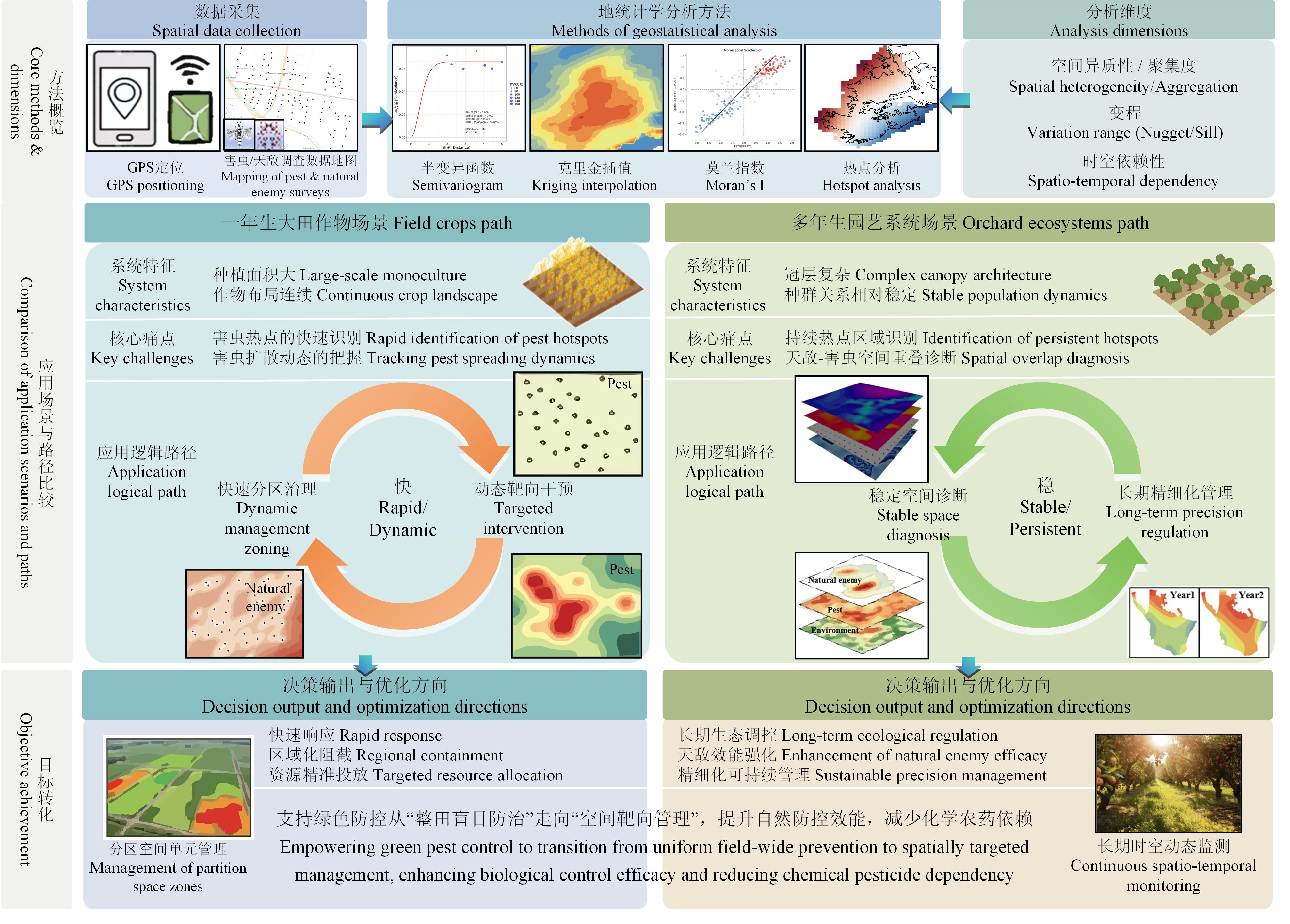
图1
地统计学在不同场景害虫防控中的应用转化比较"

图2
地统计学支持害虫-天敌精准防控的研究与决策框架图"

表1
面向数据决策的地统计学关键方法及适用条件"
| 计算类别Category | 方法名称 Method name | 核心公式 Core formula | 适用场景 Applicable scenario | 应用逻辑 Application logic |
|---|---|---|---|---|
| 克里金插值类 Kriging interpolation methods | 普通克里金 Ordinary Kriging[ | $\hat{Z}\left(s_{0}\right)=\sum_{i=1}^{n} \lambda_{i} Z\left(s_{i}\right)$ 约束条件Constraint:$\sum_{i=1}^{n} \lambda_{i}=1$ $\hat{Z}\left(s_{0}\right)$:位置s0处的预测值Predicted value at location s0;Z(si):采样点i的观测值Observed value at sampling site i;λi:权重系数Weight coefficient;n:样本点数量Number of sample points | 棉铃虫等害虫种群密度空间插值;害虫低密度区域精准预测;害虫空间分布制图;害虫种群密度空间制图 Spatial interpolation of pest population density, e.g., cotton bollworm; Precise prediction of low-density pest areas; Spatial distribution mapping of pests occurrence; Spatial distribution mapping of pests population density | 基于半方差函数建模,假设未知常数均值,通过空间权重优化实现最优线性无偏估计;适用于二阶平稳的害虫种群数据 Based on semi-variogram modeling, assuming unknown constant means, achieving the best linear unbiased prediction through spatial weight optimization; Applicable to second- order stationary pest population data |
| 简单克里金 Simple Kriging[ | $\hat{Z}\left(s_{0}\right)=\mu+\sum_{i=1}^{n} \lambda_{i}\left[Z\left(s_{i}\right)-\mu\right]$ μ:已知的总体均值Known global mean,其他参数同普通克里金Other parameters are the same as Ordinary Kriging | 已知平均密度的空间插值;病虫害历史发生区预测 Spatial interpolation with known mean density; Prediction of historical pest and disease occurrence areas | 假设总体均值已知且恒定,通过残差项加权估计未知位置的值;适用于长期监测数据充足的害虫预测Assuming the global mean is known and constant, estimating values at unknown locations by weighting residual terms; Applicable to pest prediction with sufficient long- term monitoring data | |
| 泛克里金 Universal Kriging[ | Z(s)=m(s)+∈(s); $m(s)={\displaystyle \sum _{k=0}^{p}\beta kfk(s)}$ m(s):趋势项Trend term;∈(s):残差项Residual term;βk:漂移系数Drift coefficient;fk(s):趋势函数Trend function | 环境变量影响下的害虫分布预测;存在明显空间趋势的病虫害扩散 Prediction of pest distribution under environmental factors; Pest and disease spread with distinct spatial trends | 处理非平稳空间数据,可纳入环境协变量(海拔、温度等)作为趋势项;适用于病虫害发生受地理因素显著影响的场景 Handles non-stationary spatial data by incorporating environmental covariates, e.g., elevation and temperature, as trend terms; Applicable to scenarios where pest and disease outbreaks are significantly influenced by geographical factors | |
| 协同克里金 Cokriging[ | ${\widehat{Z}}_{1}({s}_{0})={\displaystyle \sum _{i=1}^{{n}_{1}}{{\displaystyle \lambda }}_{i}^{1}{Z}_{1}({s}_{i})}+{\displaystyle \sum _{j=1}^{{n}_{2}}{{\displaystyle \lambda }}_{j}^{2}{Z}_{2}({s}_{j})}$ Z1:主要变量(害虫密度)Primary variables, e.g., pest density;Z2:辅助变量(植被指数/土壤湿度)Auxiliary variables, e.g., vegetation index/soil moisture;λ1、λ2:各变量权重Weights for each variable | 引入环境协变量的害虫分布预测 Pest distribution prediction incorporating environmental covariate | 利用多个相关变量的空间相关性提高估计精度;适用于辅助数据采样密度高于目标害虫数据的情况 Improve estimation accuracy by utilizing spatial correlation of multiple related variables; Applicable when the sampling density of secondary data is higher than that of the target pest data | |
| 指示克里金 Indicator Kriging[ | $I\left(s ; z_{c}\right)=\left\{\begin{array}{l} 1, Z(s) \leq z_{c} \\ 0, Z(s)>z_{c} \end{array}\right.$ $P\left[Z\left(s_{0}\right) \leq z_{c}\right]=\sum_{i=1}^{n} \lambda_{i} I\left(s_{i} ; z_{c}\right)$ zc:阈值(如防治指标)Threshold value, e.g., prevention Indicators;I(s; zc):指示函数,在位置s处,若实测值低于或等于阈值zc,则赋值为1,否则为0 Indicate function, at position s, to be assigned a value of 1 if the actual measured value is less than or equal to the threshold zc, otherwise 0;P:超过阈值的概率Probability of surpassing threshold | 害虫密度超过防治阈值的概率制图;病害发生风险区域划分 Probability mapping of pest density exceeding control thresholds; Risk zoning of disease and pest outbreaks | 将连续变量转换为二元指示变量,估计超过防治阈值的概率,支持精准施药决策 Converts continuous variables into binary indicator variables to estimate the probability of exceeding prevention and treatment thresholds, supporting accurate drug administration decisions | |
| 确定性插值类Deterministic interpolation | 反距离加权 Inverse distance weighting[ | $\hat{Z}\left(s_{0}\right)=\frac{\sum_{i=1}^{n} w_{i} Z\left(s_{i}\right)}{\sum_{i=1}^{n} w_{i}} \quad w_{i}=\frac{1}{d_{i 0}^{p}}$ di0:样本点到预测点的距离Distance from sample point to the predicted point;p:距离幂次(通常取2)Distance power, typically set to 2;wi:距离权重Distance weight | 害虫调查数据快速制图;实时监测数据的空间插值 Rapid mapping of pest survey data; Spatial interpolation of real-time monitoring data | 计算简便,无需建模,距离越近权重越大;适用于大规模实时监测和快速决策场景,用于样本点密集且分布均匀的场景,进行害虫密度的快速插值,为精准施药提供即时地图,但无法提供预测误差 Simplicity of calculation, no need for modeling, greater weight at closer distances; Appropriate for large-scale real-time monitoring and quick decision- making scenarios, for samples densely packed and evenly distributed scenarios, for rapid interpolation of pest density, providing an instant map for accurate drug administration but unable to provide prediction errors |
| 空间自相关类 Spatial autoocorrelation | 全局莫兰指数Global Moran’s I[ | $I=\frac{n}{{\sum }_{i}{\sum }_{j}{w}_{ij}}\frac{{\sum }_{i}{\sum }_{j}{w}_{ij}(x{}_{i}-\overline{x})({x}_{j}-\overline{x})}{{\sum }_{i}{(x{}_{i}-\overline{x})}^{2}}$ n:样本单元数Number of spatial units;xi、xj:单元i、j的观测值Observed values of units i and j;$\bar{x}$:均值Mean value;wij:空间权重矩阵元素Elements of the spatial weight matrix | 害虫种群整体聚集性检验;病害空间自相关强度评估;监测网点优化布局 Global clustering test of pest populations; Strength evaluation of disease spatial auto correlation; Optimal layout of monitoring networks | 值域[-1,1],正值表示聚集,负值表示离散,0表示随机分布;判断害虫是否呈聚集分布,指导采样策略 The value range is [-1,1], with positive values for aggregation, negative values for dispersion, and 0 for random distribution; Use to determine whether the pests are clustered or not, and guide the sampling strategy |
| 局部莫兰指数Local Moran’s I[ | ${I}_{i}=\frac{x{}_{i}-\overline{x}}{{\sigma }^{2}}{\displaystyle \sum _{j}{w}_{ij}({x}_{j}-\overline{x})}$ Ii:单元i的局部莫兰指数Local Moran’s I for unit i;σ2:方差Variance。其他参数同全局莫兰指数Other parameters are the same as Global Moran’s I | 识别害虫高密度热点区域;天敌-害虫空间关联分析;局部聚集区精准防治 Identifying high-density pest hotspots; Spatial association analysis between pests and natural enemies; Precision management of local clustered zones | 识别HH(高-高)、LL(低-低)、HL(高-低)、LH(低-高)4种局部空间模式,定位热点和冷点区域,用于发现病虫害暴发中心,实施分区管理 Identify four local spatial modes: HH (high-high), LL (low-low), HL (high-low), and LH (low-high). Locate hot and cold areas for the discovery of disease and pest outbreak centers and implement partition management | |
| 热点分析类 Hotspot analysis | Getis-Ord Gi统计量Getis-Ord Gi*[ | ${G}_{i}^{*}=\frac{{\sum }_{j}{w}_{ij}x{}_{j}-\overline{x}{\sum }_{j}{w}_{ij}}{S\sqrt{\frac{n{\sum }_{j}{w}_{ij}^{2}-{({\sum }_{j}{w}_{ij})}^{2}}{n-1}}}$ $\bar{x}$:全局均值Global mean;S:标准差Standard deviation;Gi*:标准化统计量Standardized statistics | 害虫暴发热点识别;冷点区域(天敌优势区)定位;时空热点追踪 Identification of pest outbreak hotspots; Localization of cold spots, i.e., natural enemy dominant zones; Spatio-temporal hotspot tracking | 相比于局部莫兰指数,Gi*能更纯粹地识别具有统计显著性的高值(热点)和低值(冷点)空间聚类(Z>1.96为显著热点,Z<-1.96为冷点),识别高值和低值空间聚集,常用于害虫密度热点区识别,支持靶向施药和天敌保护 Compared to the local Morland index, Gi* can more purely identify high-value (hot spots) and low-value (cold spots) spatial clustering with statistical significance (Z>1.96 for significant hot spots, Z<-1.96 for cold spots), identify high-value and low-value spatial clustering, commonly used for pest density hot spot area identification, support for targeted drug administration and nemesis protection |
| 空间关联可视化Spatial association visualization | Moran散点图 Moran scatterplot[ | 横轴x axis:$z_{i}=\frac{x_{i}-\bar{x}}{\sigma}$ 纵轴y axis:Wzi=∑jwijzj zi:标准化值Standardized value;Wzi:空间滞后的标准化值Standardized value of spatial lag | 识别空间异常值;可视化空间关联模式;检测边缘效应 Identification of spatial outliers; Visualization of spatial association patterns; Detection of edge effects | 四象限分类:HH(热点)、LL(冷点)、HL/LH(空间异常值)。直观展示空间聚集模式,辅助决策 Four quadrant categories: HH (hot spots), LL (cold spots), HL/LH (spatial anomaly value). Visualize spatial clustering patterns to assist in decision making |
| 聚集度指数类 Aggregation indices | 负二项分布指标K Negative binomial K[ | $K=\frac{{\overline{x}}^{2}}{{s}^{2}-\overline{x}}$ $\bar{x}$:样方均值Mean square of a sample;s2:样方方差Variance of the sample。K越小聚集越强The smaller K, the stronger the cluster | 样方调查数据聚集度量化;田间害虫空间格局判定 Aggregation measurement of sample survey data; Determination of field pest spatial patterns | K<0高度聚集,K→∞趋于随机分布。常用于昆虫种群空间格局的基本判定 K<0 is highly clustered, and K→∞ tends to be randomly distributed. A basic determination often used for the spatial layout of insect populations |
| 平均拥挤度 Mean crowding[ | ${M}^{*}=\overline{x}+\frac{{s}^{2}}{\overline{x}}-1$ M*:平均拥挤度,值越大个体间拥挤程度越高Mean crowding index, higher values indicate higher crowding among individuals | 害虫种内竞争强度评估;最适采样单元确定 Evaluation of intraspecific competition intensity in pests; Determination of optimal sampling units | 反映个体平均遇到的同种个体数,结合密度指导防治时机和强度 Reflecting the average number of individuals of the same species encountered by individuals, combined with density guidance on timing and intensity of prevention | |
| 距离分析类 Distance analysis | 最近邻距离法Nearest neighbor distance[ | $R=\frac{\bar{r}_{o}}{\bar{r}_{e}} \quad \bar{r}_{e}=\frac{1}{2 \sqrt{\rho}}$ $\bar{r}_{o}$:观测的平均最近邻距离Observed mean nearest neighbor distance;$\bar{r}_{e}$:期望最近邻距离Expected mean nearest neighbor distance;ρ:密度(个体数/面积)Density (number of individuals/area) | 点格局分析;害虫发生中心识别;陷阱布设优化;种群分布模式判别 Point pattern analysis; Population distribution pattern identification; Trap deployment optimization; Identification of pest outbreak centers | 通过计算每个点到其最近邻点的平均距离,与理论随机分布下的期望距离进行比较,以R值判断种群为均匀(R>1)、随机(R≈1)或聚集(R<1)分布;基于点位置数据,适用于诱捕器/陷阱监测数据分析 By calculating the average distance from each point to its nearest neighbor and comparing it with the expected distance under the theoretical random distribution, the R value determines that the population is uniform (R>1), random (R≈1), or clustered (R<1) distribution; Based on point location data, applicable for trap/trap monitoring data analysis |
| 空间结构分析 Spatial structure analysis | 半方差函数 Semivariogram[ | $\gamma (h)=\frac{1}{2N(h)}{\displaystyle \sum _{i=1}^{N(h)}{[Z({s}_{i})-Z({s}_{i}+h)]}^{2}}$ h:滞后距离Lag distance;N(h):距离为h的点对数Number of sample pairs separated by lag distance h;γ(h):半方差Semi- variance value | 确定害虫空间依赖范围;优化监测网点间距;选择合适的克里金模型 Determining the spatial dependence range of pests; Optimizing monitoring network spacing; Selecting appropriate Kriging theoretical models | 通过拟合理论模型(球状、指数、高斯)获得基台值、变程和块金值,揭示空间结构特征 Base values, variables, and block gold values are obtained through fitting theoretical models (sphere, exponential, gaussian), revealing spatial structural characteristics |
| 多变量空间分析Multivariate spatial analysis | 交叉半方差函数 Cross- variogram[ | ${\gamma }_{12}(h)=\frac{1}{2N(h)}{\displaystyle \sum _{i=1}^{N(h)}[{Z}_{1}({s}_{i})-{Z}_{1}({s}_{i}+h)]}$ [Z2(si)-Z2(si+h)] Z1、Z2:两个变量(如害虫与天敌)Two different variables, e.g., pests and natural enemies;γ12(h):交叉半方差Cross semi- variance value | 害虫-天敌空间关系;病害-环境因子关联;协同克里金前期分析 Pest-natural enemy spatial relationship analysis; Disease-environmental factor association studies; Pre- requisite analysis for Cokriging | 量化两个变量间的空间协变关系,为协同克里金插值提供理论基础 Quantifying the spatial covariant relationship between two variables to provide the theoretical basis for the synergistic Kriging interpolation |
| 空间回归类 Spatial regression | 空间滞后模型Spatial lag model[ | Y=ρWY+Xβ+∈,Y:因变量(害虫密度)Dependent variable, e.g., pest density;WY:空间滞后项Spatial lag term;ρ:空间自回归系数Spatial auto regressive coefficient;Xβ:协变量项Covariate term | 环境因子对害虫分布的影响建模;考虑邻域效应的预测模型 Modeling environmental impacts on pest distribution; Predictive models incorporating neighborhood spillover effects | 处理因变量的空间溢出效应,适用于害虫扩散受邻近区域影响的场景 Handling spatial spillover effects of dependent variables is suitable for scenarios where pest propagation is affected by nearby areas |
| 空间误差模型Spatial error model[ | Y=Xβ+u;u=λWu+∈。u:误差项Error term;λ:空间误差系数Spatial error coefficient;Wu:空间滞后误差Spatial lag error | 控制空间自相关偏误;提高回归模型精度Controlling spatial auto correlation bias; Improving the estimation accuracy of regression models | 处理误差项的空间自相关,适用于残差存在空间聚集的回归分析 The spatial self-correlation of the error-handled terms is applicable for regression analysis of spatial aggregations with residual presence |
| [1] |
|
| [2] |
doi: 10.1002/ps.v77.2 |
| [3] |
陈学新, 刘银泉, 任顺祥, 张帆, 张文庆, 戈峰. 害虫天敌的植物支持系统[J]. 应用昆虫学报, 2014, 51(1): 1-12.
|
|
|
|
| [4] |
doi: 10.3390/agronomy9090532 |
| [5] |
doi: 10.1002/ps.v81.12 |
| [6] |
doi: 10.1111/enr.v52.8 |
| [7] |
doi: 10.1002/ps.v75.12 |
| [8] |
周强, 张润杰, 古德祥. 地质统计学在昆虫种群空间结构研究中的应用概述[J]. 动物学研究, 1998, 19(6): 482-488.
|
|
|
|
| [9] |
doi: 10.2307/2937096 |
| [10] |
doi: 10.2113/gsecongeo.58.8.1246 |
| [11] |
doi: 10.1007/s11004-005-1560-6 |
| [12] |
doi: 10.17221/40/2013-PPS |
| [13] |
doi: 10.1146/ento.1993.38.issue-1 |
| [14] |
doi: 10.1093/ee/nvx145 pmid: 29029089 |
| [15] |
doi: 10.1002/ps.4664 pmid: 28714108 |
| [16] |
doi: 10.1111/een.v47.6 |
| [17] |
孙佳照, 张淋, 李子朝, 邹运鼎, 毕守东. 5种茶园秋冬季天敌与假眼小绿叶蝉空间关系密切程度的差异[J]. 生态学报, 2021, 41(20): 8297-8307.
|
|
|
|
| [18] |
doi: 10.3390/insects14040379 |
| [19] |
doi: 10.1007/s10668-023-03927-1 |
| [20] |
doi: 10.1007/s13744-016-0453-3 pmid: 27826872 |
| [21] |
doi: 10.1038/s41598-021-92562-9 |
| [22] |
doi: 10.1093/jee/toy110 |
| [23] |
doi: 10.1002/ps.6237 pmid: 33342051 |
| [24] |
doi: 10.3389/fagro.2022.958498 |
| [25] |
doi: 10.1002/ps.v77.11 |
| [26] |
doi: 10.1007/s11119-023-10041-9 |
| [27] |
doi: 10.1080/09583157.2023.2165038 |
| [28] |
余晓倩, 贺泽帅, 丁荣荣, 陈良越, 张大治. 苦豆子豆荚螟及其寄生性天敌空间格局的地统计学分析[J/OL]. 环境昆虫学报, https://link.cnki.net/urlid/44.1640.Q.20250410.1448.002.
|
|
|
|
| [29] |
doi: 10.1016/j.agee.2005.09.011 |
| [30] |
doi: 10.31026/j.eng.2021.12 |
| [31] |
|
| [32] |
doi: 10.1111/eea.2010.137.issue-3 |
| [33] |
doi: 10.1007/s10340-016-0823-y |
| [34] |
|
| [35] |
doi: 10.1111/geb.2007.16.issue-2 |
| [36] |
doi: 10.1007/s11119-022-09902-6 |
| [37] |
doi: 10.1038/s41559-017-0357-6 |
| [38] |
doi: 10.31285/AGRO.22.1.1 |
| [39] |
doi: 10.3390/agriculture13020438 |
| [40] |
doi: 10.1016/j.cropro.2023.106499 |
| [41] |
doi: 10.1016/j.aspen.2019.07.006 |
| [42] |
doi: 10.1007/s42690-022-00802-w |
| [43] |
doi: 10.1080/09670874.2023.2179126 |
| [44] |
|
| [45] |
doi: 10.1002/ps.5251 pmid: 30375149 |
| [46] |
doi: 10.3390/agronomy13102581 |
| [47] |
doi: 10.1093/ee/27.4.910 |
| [48] |
doi: 10.1002/ps.v82.8 |
| [49] |
doi: 10.1080/09670874.2023.2179125 |
| [50] |
doi: 10.1603/EN13332 pmid: 24735500 |
| [51] |
doi: 10.1007/s13744-021-00880-4 pmid: 34110600 |
| [52] |
doi: 10.1038/s41598-019-57077-4 pmid: 31941914 |
| [53] |
doi: 10.1111/1365-2664.13353 |
| [54] |
doi: 10.1016/j.agrcom.2025.100097 |
| [55] |
doi: 10.1007/s10340-020-01285-9 |
| [56] |
doi: 10.1111/gcb.14862 pmid: 31596997 |
| [57] |
doi: 10.1007/s11119-012-9259-4 |
| [58] |
doi: 10.1034/j.1600-0587.2002.250507.x |
| [59] |
王正军, 李典谟, 商晗武, 程家安. 地质统计学理论与方法及其在昆虫生态学中的应用[J]. 昆虫知识, 2002, 39(6): 405-411.
|
|
|
|
| [60] |
|
| [61] |
|
| [62] |
|
| [63] |
|
| [64] |
doi: 10.1007/s00477-008-0226-6 |
| [65] |
doi: 10.1038/s41598-021-82227-y |
| [66] |
doi: 10.1111/gean.1995.27.issue-2 |
| [67] |
doi: 10.1111/gean.1992.24.issue-3 |
| [68] |
|
| [69] |
|
| [70] |
doi: 10.2307/3012 |
| [71] |
doi: 10.2307/1931034 |
| [72] |
doi: 10.1111/mee3.v13.6 |
| [73] |
|
| [74] |
doi: 10.3390/insects12050402 |
| [75] |
马志芳, 张大治, 贺泽帅, 张圣昕. 沙冬青豆荚螟-天敌空间分布的地统计学分析[J]. 植物保护, 2020, 46(5): 128-132.
|
|
|
|
| [76] |
doi: 10.3390/insects12100854 |
| [77] |
李姝, 王杰, 黄宁兴, 金振宇, 王甦, 张帆. 捕食性天敌储蓄植物系统研究进展与展望[J]. 中国农业科学, 2020, 53(19): 3975-3987. DOI: 10.3864/j.issn.0578-1752.2020.19.011.
|
|
|
|
| [78] |
戈峰, 门兴元, 鞠倩, 于凯, 张兴瑞, 李卓, 梁潇以, 张玉娇. 农田生态服务区构建原理、方法及应用[J]. 生态学报, 2025, 45(24): 12518-12526.
|
|
|
|
| [79] |
doi: 10.1126/science.adr2146 pmid: 40997179 |
| [80] |
doi: 10.1111/afe.2017.19.issue-1 |
| [81] |
|
| [82] |
doi: 10.1111/mee3.v12.6 |
| [83] |
doi: 10.3390/rs14071604 |
| [84] |
doi: 10.3389/fpls.2025.1721484 |
| [85] |
doi: 10.1603/0046-225X-31.1.160 |
| [86] |
doi: 10.1016/j.landurbplan.2016.05.004 |
| [87] |
doi: 10.1016/j.cub.2023.04.074 |
| [88] |
doi: 10.1016/j.cageo.2024.105833 |
| [89] |
doi: 10.1111/j.1461-0248.2010.01567.x pmid: 21155962 |
| [90] |
doi: 10.3390/rs15030656 |
| [91] |
doi: 10.1016/j.compag.2024.108726 |
| [92] |
doi: 10.3390/insects14060555 |
| [1] | 王晶, 李岗, 蔡晓雅, 庞璐瑶, 黄青滢, 林宝义, 孔海民, 郝跃, 任海英. 杨梅凋萎病生防芽孢杆菌的筛选及其防病机制[J]. 中国农业科学, 2026, 59(7): 1467-1479. |
| [2] | 鄢文英, 张元珍, 吴洪鑫, 庞锐, 陈泽鹏, 金丰良, 许小霞. 靶向小菜蛾PxGNBP3的RNAi增效绿僵菌构建及其免疫调控机制[J]. 中国农业科学, 2026, 59(3): 556-574. |
| [3] | 赵星宇, 高艳, 唐新科, 奉茵陈, 陈思颖, 顾天宇, 彭佳师. 铁在内生放线菌OsiPR-1诱导水稻稻瘟病抗性中的作用[J]. 中国农业科学, 2026, 59(13): 2828-2840. |
| [4] | 刘羽凡, 陈峥, 陈德局, 刘欣, 肖荣凤, 王阶平, 王璕, 刘波, 何进, 陈梅春. 芽孢杆菌脂肽靶向减弱青枯雷尔氏菌致病力的生防作用[J]. 中国农业科学, 2026, 59(13): 2853-2866. |
| [5] | 从琪琪, 张静怡, 孟祥龙, 戴蓬博, 李波, 胡同乐, 王树桐, 曹克强, 王亚南. 我国苹果轮纹病弱毒菌株中病毒的鉴定及其携带情况的检测[J]. 中国农业科学, 2025, 58(3): 478-492. |
| [6] | 谢海鹏, 林俊旭, 刘勇, 麦贤俊, 罗丰, 王学武, 谢文, 李少卡, 孔祥义, 吴小燕. 施用不同有机肥对贝莱斯芽孢杆菌SD13防控豇豆枯萎病的影响[J]. 中国农业科学, 2025, 58(21): 4405-4420. |
| [7] | 胡佳燕, 沈之涵, 温丽慧, 郁嘉豪, 章雨君, 蒋冬花. 水稻细菌性条斑病菌拮抗放线菌的鉴定及其防病和促生功能[J]. 中国农业科学, 2025, 58(17): 3434-3450. |
| [8] | 赵琳琳, 贺羽茜, 彭杰丽, 王旭, 马佳, 张秀敏, 胡栋. 链霉菌TOR3209及其挥发性有机化合物提高烟草抗木贼镰孢的能力[J]. 中国农业科学, 2025, 58(11): 2162-2175. |
| [9] | 廖鑫琳, 郭鑫, 杨季学, 邵嘉朱, 袁歆瑜, 胡佳燕, 陈晓晓, 蒋冬花. 拮抗青枯雷尔氏菌的放线菌筛选及其防病作用[J]. 中国农业科学, 2024, 57(7): 1319-1334. |
| [10] | 石娜, 路杨, 隋丽, 王佳江, 赵宇, 李启云, 张正坤. 莱氏绿僵菌与异色瓢虫协同增效防治蚜虫研究[J]. 中国农业科学, 2024, 57(17): 3398-3407. |
| [11] | 陈实, 黄银兰, 金云翔, 徐成林, 邹金秋. 中国北部冬小麦安全种植的农业气候因子及其阈值[J]. 中国农业科学, 2024, 57(16): 3142-3153. |
| [12] | 罗万珍, 王丹, 齐宏玥, 王彤, 刘政, 田李, 戴小枫, 陈捷胤, 麦合木提江·米吉提. 拮抗细菌KRS022的鉴定及对大丽轮枝菌的抑制效果[J]. 中国农业科学, 2023, 56(4): 649-664. |
| [13] | 郭宁, 孙华, 马红霞, 刘树森, 张海剑, 石洁, 郑晓娟, 董跃广. 玉米腐霉茎腐病生防木霉菌株的筛选、鉴定及防治效果分析[J]. 中国农业科学, 2023, 56(22): 4453-4466. |
| [14] | 王炫栋, 宋振, 兰赫婷, 江樱姿, 齐文杰, 刘晓阳, 蒋冬花. 杨梅园土壤优势放线菌的分离及其防病促生功能[J]. 中国农业科学, 2023, 56(2): 275-286. |
| [15] | 沙月霞, 黄泽阳, 马瑞. 嗜碱假单胞菌Ej2对稻瘟病的防治效果及对水稻内源激素的影响[J]. 中国农业科学, 2022, 55(2): 320-328. |
|
||
