


中国农业科学 ›› 2021, Vol. 54 ›› Issue (11): 2302-2318.doi: 10.3864/j.issn.0578-1752.2021.11.005
周珂1,3( ),柳乐1,3,张俨娜2(),苗茹1,3,杨阳1,3
收稿日期:2020-08-01
接受日期:2020-09-27
出版日期:2021-06-01
发布日期:2021-06-09
联系方式:
周珂,E-mail:zhouke@radi.ac.cn。
基金资助:
ZHOU Ke1,3(),LIU Le1,3,ZHANG YanNa2(),MIAO Ru1,3,YANG Yang1,3
Received:2020-08-01
Accepted:2020-09-27
Published:2021-06-01
Online:2021-06-09
摘要:
【目的】使用遥感技术对2017—2020年河南省冬小麦的空间分布信息进行高精度的提取,然后对2020年冬小麦的长势进行高频度的监测并结合气象条件进行分析。【方法】本文基于谷歌地球引擎(Google Earth Engine,GEE)云平台,对选取的Landsat 8影像数据根据NDVI最大值进行合成,然后进行特征构建,添加地形特征、纹理特征、NDVI以及一个新特征NDVI增幅,使用随机森林分类方法对样本数据按照构建的特征进行训练提取河南省2017—2020年冬小麦的播种面积信息;经过精度验证后对提取的河南省2020年的冬小麦种植区域生成掩膜,对掩膜区域(冬小麦种植区域)结合MODIS高时间分辨率影像数据,使用NDVI同期差值法对2020年2—4月份的冬小麦进行高频度的长势监测。【结果】使用GEE云平台能够对河南省冬小麦种植区域的空间分布信息进行快速制图;使用随机森林方法加入地形特征、纹理特征、NDVI后再加入新特征NDVI增幅,能够有效提高冬小麦的提取精度以及降低与统计数据的相对误差,基于混淆矩阵计算的平均总体分类精度为95.2%、平均kappa系数为0.909、冬小麦的平均分类精度为95.3%,与河南省统计年鉴数据相比,本文方法提取的2017—2019年河南省冬小麦播种面积相对误差均低于3%,河南省冬小麦主要种植区域的冬小麦播种面积的平均相对误差低于6%;使用MODIS影像数据结合NDVI差值模型能够对河南省2020年的冬小麦进行高频度的长势监测,河南省冬小麦在返青初期长势较往年及2019年好,到生育后期大部分区域长势与往年及2019年持平,总体上2020年冬小麦的长势较往年及2019年好。【结论】本文提出的方法能够对河南省冬小麦进行高精度的提取以及高频度的长势监测,且能够为地方政府或者一些农业部门在安排指导农事活动上提供科学依据。
周珂, 柳乐, 张俨娜, 苗茹, 杨阳. GEE支持下的河南省冬小麦面积提取及长势监测[J]. 中国农业科学, 2021, 54(11): 2302-2318.
ZHOU Ke, LIU Le, ZHANG YanNa, MIAO Ru, YANG Yang. Area Extraction and Growth Monitoring of Winter Wheat in Henan Province Supported by Google Earth Engine[J]. Scientia Agricultura Sinica, 2021, 54(11): 2302-2318.

图1
研究区域地形图"
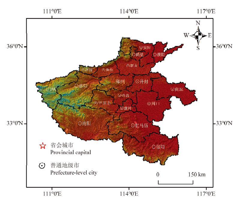
表1
河南省冬小麦生育周期"
| 月份Month | 09 | 10 | 11 | 12 | 01 | 02 | 03 | 04 | 05 | 06 | ||||||||||||||||||||
|---|---|---|---|---|---|---|---|---|---|---|---|---|---|---|---|---|---|---|---|---|---|---|---|---|---|---|---|---|---|---|
| 旬 Ten days | 上 First | 中Middle | 下 Last | 上First | 中Middle | 下Last | 上First | 中Middle | 下Last | 上First | 中Middle | 下Last | 上First | 中Middle | 下Last | 上First | 中 Middle | 下 Last | 上 First | 中Middle | 下Last | 上 First | 中Middle | 下 Last | 上 First | 中 Middle | 下 Last | 上 First | 中Middle | 下 Last |
| 冬小麦生 育期 Winter wheat growth period | 播种期 Sowing stage | 出苗-三叶期 Regreening stage | 分蘖期 Tillering stage | 越冬期 Over-wintering stage | 返青期 Re-greening stage | 起身拔节期 Rising stage | 孕穗-抽穗期 Heading stage | 开花期 Flowering stage | 灌浆乳熟期 Mature stage | |||||||||||||||||||||
表2
Landsat 8选取影像详情"
| 年份 Year | 日期 Date (M-D) | 选用影像数据年份Year of image data selected | 筛选云量 Cloud covered | 数量 Count |
|---|---|---|---|---|
| 2017-2018 | 09-15—11-15 | 2015-2017 | <20% | 70 |
| 12-01—03-25 | 2015-2018 | <20% | 133 | |
| 2018-2019 | 09-15—11-15 | 2016-2018 | <20% | 83 |
| 12-01—03-25 | 2016-2019 | <20% | 125 | |
| 2019-2020 | 09-15—11-15 | 2017-2019 | <20% | 94 |
| 12-01—03-25 | 2019-2020 | <10% | 36 |
表3
样本选取依据"
| 样本种类 Sample type | 解译标志 Interpretation mark | 描述 Description |
|---|---|---|
| 冬小麦 Winter wheat |   | 研究区域冬小麦主要分布在平原地带的农村周边,在Google earth纹理较为清晰,成片出现,有较为规则的形状(矩形),颜色为绿色或深绿色 Winter wheat in the study area is mainly distributed in the rural periphery of the plain area, the texture of Google earth is relatively clear, appears in pieces, has a more regular shape (rectangle), and the color is green or dark green |
| 水体 Water |   | 研究区域的水体区域主要由水库、湖泊、河流等组成,纹理上边缘明显,在颜色上水体区域在颜色上的表现为青色、淡蓝以及土黄色(黄河) The water area of the study area is mainly composed of reservoirs, lakes, rivers and so on, and the upper edge of the texture is obvious. In color, the water area is cyan, light blue and earth yellow |
| 不透水面Town |   | 研究区域内的不透水面有城镇建筑以及城镇周边道路组成,在Google earth上纹理信息较明显,也是成片出现,能够清晰的识别 The impervious water surface in the study area is composed of urban buildings and roads around towns, and the texture information is more obvious on Google earth, and it also appears in pieces, which can be clearly identified |
| 其他植被 Other vegetation |   | 其他植被由山体植被、城镇中的景观植物以及裸地植被等组成。在Google earth上此类地物具有清晰的特征,山体植被海拔较高成山体状;景观植物分布在城镇生活区域中;裸地植被也分布于城镇各处,表面较为稀疏 Other vegetation is composed of mountain vegetation, urban landscape plants and bare land vegetation. On Google earth, such features have clear characteristics, mountain vegetation is mountain-shaped at high altitude; Landscape plants are distributed in urban living areas; Bare land vegetation is also distributed throughout cities and towns, and the surface is relatively sparse |
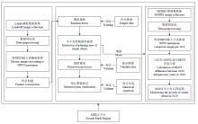
图2
冬小麦长势监测流程"
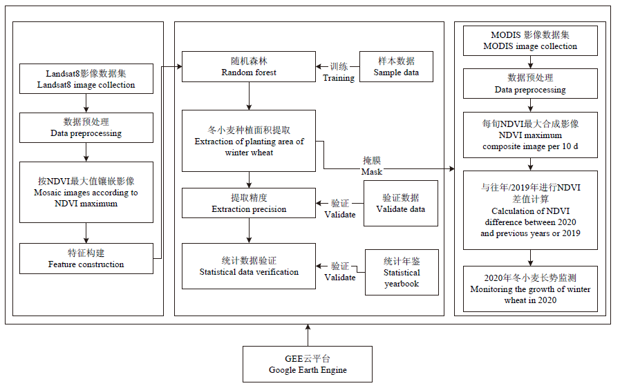
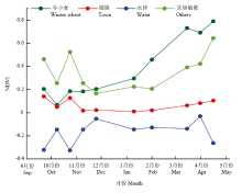
图3
研究区各类地物时序NDVI变化"
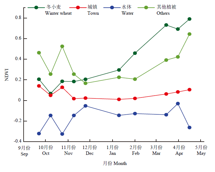
表4
河南省冬小麦遥感提取的播种面积与统计的播种面积比较"
| 特征 Feature | 年份 Year | 提取面积 Extraction area (hm2) | 统计面积 Statistical area (hm2) | 绝对误差 Absolute error (hm2) | 相对误差 Relative error (%) |
|---|---|---|---|---|---|
| 光谱+地形+纹理+NDVI Spectrum + terrain + texture + NDVI | 2017-2018 | 5930815 | 5714640 | 216175 | 3.78 |
| 2018-2019 | 6043211 | 5739850 | 303361 | 5.28 | |
| 光谱+地形+纹理+NDVI+NDVI增幅 Spectrum+topography+texture+NDVI+ NDVIincrease | 2017-2018 | 5548529 | 5714640 | 166111 | 2.91 |
| 2018-2019 | 5604970 | 5739850 | 134670 | 2.35 | |
| 2019-2020 | 5843632 |
表5
河南省冬小麦主要种植区域的遥感提取的播种面积与统计的播种面积比较"
| 特征 Feature | 2017-2018 | 2018-2019 | |||||||
|---|---|---|---|---|---|---|---|---|---|
| 光谱+地形+纹理+NDVI Spectrum + topography + texture + NDVI | 市 City | 提取面积 Extraction area (hm2) | 统计面积 Statistical area (hm2) | 绝对误差 Absolute error (hm2) | 相对误差 Relative error (%) | 提取面积 Extraction area (hm2) | 统计面积 Statistical area (hm2) | 绝对误差 Absolute error (hm2) | 相对误差 Relative error (%) |
| 南阳 Nanyang | 803278 | 709020 | 94258 | 13.29 | 771926 | 724660 | 47266 | 4.09 | |
| 驻马店 Zhumadian | 929103 | 750520 | 178583 | 23.79 | 914174 | 781670 | 132504 | 16.95 | |
| 周口 Zhoukou | 846381 | 718350 | 128031 | 17.82 | 893891 | 734380 | 159511 | 21.72 | |
| 商丘 Shangqiu | 611644 | 588870 | 22774 | 3.87 | 705349 | 603380 | 101969 | 16.90 | |
| 开封 Kaifeng | 330408 | 299920 | 30488 | 10.16 | 322177 | 305200 | 16977 | 5.50 | |
| 许昌 Xuchang | 238458 | 228960 | 9498 | 4.15 | 226581 | 233010 | 6429 | 2.76 | |
| 新乡 Xinxiang | 442132 | 379410 | 62722 | 16.53 | 437147 | 387670 | 49477 | 12.76 | |
| 安阳 Anyang | 307150 | 320380 | 13230 | 7.22 | 305831 | 325730 | 19539 | 6.00 | |
| 光谱+地形+纹理+ NDVI+NDVI增幅 Spectrum + topography +texture+NDVI+ NDVIincrease | 南阳 Nanyang | 721819 | 709020 | 12799 | 1.81 | 695001 | 724660 | 29659 | 4.09 |
| 驻马店 Zhumadian | 849960 | 750520 | 9944 | 13.25 | 834591 | 781670 | 52921 | 6.77 | |
| 周口 Zhoukou | 809734 | 718350 | 91384 | 12.72 | 808415 | 734380 | 74035 | 10.08 | |
| 商丘 Shangqiu | 575660 | 588870 | 13210 | 2.24 | 629586 | 603380 | 26206 | 4.34 | |
| 开封 Kaifeng | 300274 | 299920 | 354 | 0.12 | 316275 | 305200 | 11075 | 3.63 | |
| 许昌 Xuchang | 230127 | 228960 | 1167 | 0.51 | 224240 | 233010 | 8770 | 3.76 | |
| 新乡 Xinxiang | 427995 | 379410 | 485.85 | 12.80 | 41784 | 387670 | 30170 | 7.78 | |
| 安阳 Anyang | 313655 | 320380 | 6725 | 2.10 | 304353 | 325730 | 11377 | 3.49 | |
表6
研究区冬小麦基于混淆矩阵提取精度比较"
| 特征 Feature | 年份 Year | 总体精度 OA (%) | Kappa系数 Kappa | 冬小麦分类精度 Classification accuracy of winter wheat (%) |
|---|---|---|---|---|
| 光谱+地形+纹理+NDVI Spectrum + topography + texture + NDVI | 2017-2018 | 93.3 | 0.862 | 93.5 |
| 2018-2019 | 94.8 | 0.891 | 95.1 | |
| 2019-2020 | 94.7 | 0.892 | 94.5 | |
| 光谱+地形+纹理+NDVI+NDVI增幅 Spectrum + topography + texture + NDVI+NDVIincrease | 2017-2018 | 94.8 | 0.893 | 94.6 |
| 2018-2019 | 95.6 | 0.921 | 95.3 | |
| 2019-2020 | 95.8 | 0.913 | 95.9 |
图4
研究区2017—2020年冬小麦播种面积分布图"
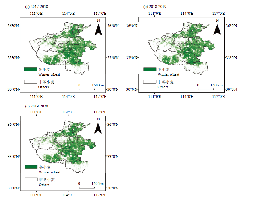
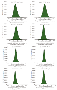
图5
2020年冬小麦种植区域与往年相比的NDVI变化"
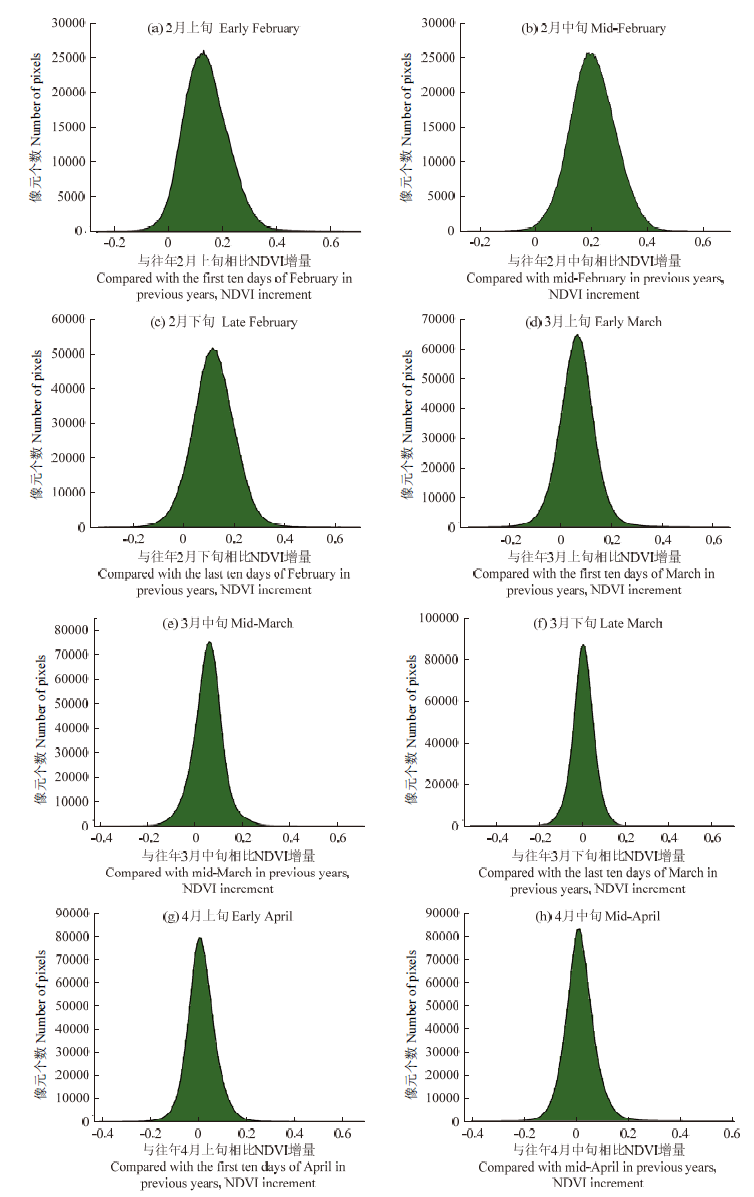
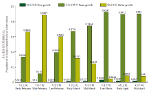
图6
与2019年相比研究区2020年2—4月的冬小麦的长势情况"
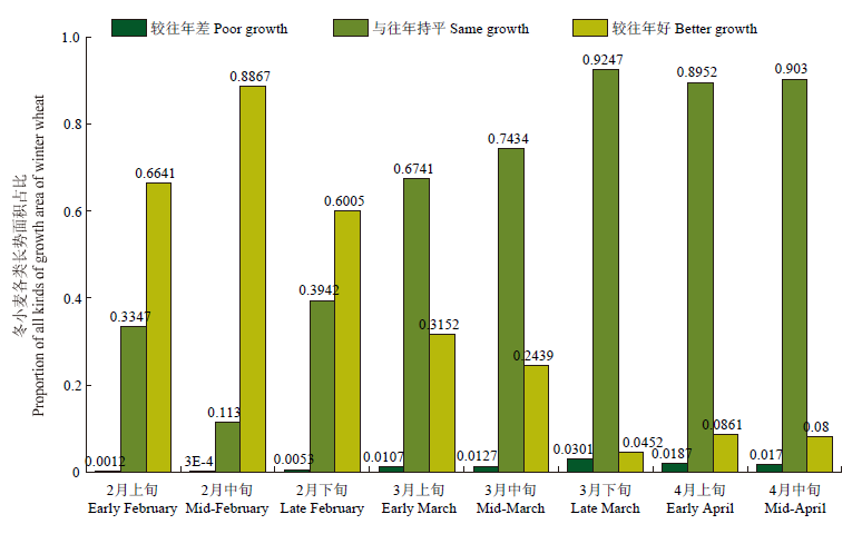
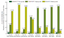
图7
与往年相比研究区2020年2—4月的冬小麦的长势情况"
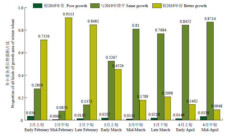

图8
与往年相比研究区2020年2—4月的冬小麦的长势分布"
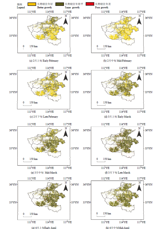
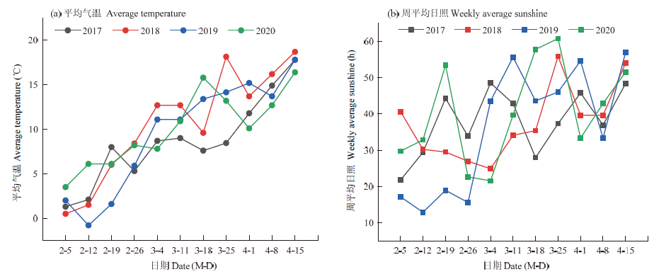
图9
2017—2020年2—4月份的平均气温及周平均日照"
| [1] | 郑文倩. 我国小麦价格形成机制及波动特征分析[D]. 北京: 中国农业科学院, 2016. |
| ZHENG W Q. Study on wheat price formation mechanism and price volatility characteristics in China[D]. Beijing: Chinese Academy of Agricultural Sciences, 2016. (in Chinese) | |
| [2] | 盛磊, 何亚娟, 吴全, 王飞. 河南省冬小麦产量遥感监测精度比较研究. 中国农业信息, 2018,30(2):95-102. |
| SHENG L, HE Y J, WU Q, WANG F. Comparative study on accuracy of winter wheat production by remote sensing monitoring in Henan province. China Agricultural Information, 2018,30(2):95-102. (in Chinese) | |
| [3] |
HAN J C, ZHANG Z, CAO J, LUO Y C, ZHANG L L, LI Z Y, ZHANG J. Prediction of winter wheat yield based on multi-source data and machine learning in China. Remote Sensing, 2020,12(2):236.
doi: 10.3390/rs12020236 |
| [4] | 刘新杰, 魏云霞, 焦全军, 孙奇, 刘良云. 基于时序定量遥感的冬小麦长势监测与估产研究. 遥感技术与应用, 2019,34(4):756-765. |
| LIU X J, WEI Y X, JIAO Q J, SUN Q, LIU L Y. Growth monitoring and yield prediction of winter wheat based on time-series quantitative remote sensing data. Remote Sensing Technology and Application, 2019,34(4):756-765. (in Chinese) | |
| [5] | 杨珺雯, 张锦水, 潘耀忠, 孙佩军, 朱爽. 基于遥感识别误差校正面积的农作物种植面积抽样高效分层指标研究——以冬小麦为例. 中国农业科学, 2018,51(4):675-687. |
| YANG J W, ZHANG J S, PAN Y Z, SUN P J, ZHU S. An efficient hierarchical indicator based on the correction area of remote sensing identification error for planting acreage sampling-A case study of winter wheat. Scientia Agricultura Sinica, 2018,51(4):675-687. (in Chinese) | |
| [6] |
FRANCH B, VERMOTE E F, SKAKUN S, ROGER J C, BECKER- RESHEF I, MURPHY E, JUSTICE C. Remote sensing based yield monitoring: Application to winter wheat in United States and Ukraine. International Journal of Applied Earth Observation and Geoinformation, 2019,76:112-127.
doi: 10.1016/j.jag.2018.11.012 |
| [7] |
HAO Z, ZHAO H L, ZHANG C, WANG H, JIANG Y, YI Z. Estimating winter wheat area based on an SVM and the variable fuzzy set method. Remote Sensing Letters, 2019,10(4):343-352.
doi: 10.1080/2150704X.2018.1552811 |
| [8] |
ZHANG X W, LIU J F, QIN Z Y, QIN F. Winter wheat identification by integrating spectral and temporal information derived from multi- resolution remote sensing data. Journal of Integrative Agriculture, 2019,18(11):2628-2643.
doi: 10.1016/S2095-3119(19)62615-8 |
| [9] |
MENG S Y, ZHONG Y F, LUO C, HU X, WANG X Y, HUANG S X. Optimal temporal window selection for winter wheat and wapeseed mapping with sentinel-2 images: A case study of Zhongxiang in China. Remote Sensing, 2020,12(2):226.
doi: 10.3390/rs12020226 |
| [10] | 谭昌伟, 罗明, 杨昕, 马昌, 严翔, 周健, 杜颖, 王雅楠. 用PLS算法由HJ-1A/1B遥感影像估测区域冬小麦理论产量. 中国农业科学, 2015,48(20):4033-4041. |
| TAN C W, LUO M, YANG X, MA C, YAN X, ZHOU J, DU Y, WANG Y N. Remote sensing estimation of winter wheat theoretical yield on regional scale using partial least squares regression algorithm based on HJ-1A/1B images. Scientia Agricultura Sinica, 2015,48(20):4033-4041. (in Chinese) | |
| [11] | DONG C, ZHAO G X, QIN Y W, WAN H. Area extraction and spatiotemporal characteristics of winter wheat-summer maize in Shandong province using NDVI time series. PLoS ONE, 2019,14(12):226508. |
| [12] | 王利民, 刘佳, 姚保民, 季富华, 杨福刚. 基于GF-1影像NDVI年度间相关分析的冬小麦面积变化监测. 农业工程学报, 2018,34(8):184-191. |
| WANG L M, LIU J, YAO B M, JI F H, YANG F G. Area change monitoring of winter wheat based on relationship analysis of GF-1 NDVI among different years. Transactions of the Chinese Society of Agricultural Engineering, 2018,34(8):184-191. (in Chinese) | |
| [13] | 申健, 常庆瑞, 李粉玲, 王力. 基于时序NDVI的关中地区冬小麦种植信息遥感提取. 农业机械学报, 2017,48(3):215-220, 260. |
| SHEN J, CHANG Q R, LI F L, WANG L. Extraction of winter wheat information based on time-series NDVI in Guanzhong area. Transactions of the Chinese Society for Agricultural Machinery, 2017,48(3):215-220, 260. (in Chinese) | |
| [14] | 安塞, 沈彦俊, 赵彦茜, 郭英, 郭硕, 肖捷颖. 基于NDVI时间序列数据的冬小麦种植面积提取. 江苏农业科学, 2019,47(15):236-240. |
| AN S, SHEN Y J, ZHAO Y Q, GUO Y, GUO S, XIAO J Y. Extraction of winter wheat planting area based on NDVI time series data. Jiangsu Agricultural Science, 2019,47(15):236-240. (in Chinese) | |
| [15] | SHAN J, WANG Z M, SUN L, QIU L, YU K, WNAG J G. Study on extraction methods of winter wheat area based on GF-1 satellite images//2019 8th International Conference on Agro-Geoinformatics (Agro-Geoinformatics). IEEE, 2019: 1-5. |
| [16] | 罗桓, 李卫国, 景元书, 徐向华, 陈华. 基于SVM的县域冬小麦种植面积遥感提取. 麦类作物学报, 2019,39(4):81-88. |
| LUO H, LI W G, JING Y S, XU X H, CHEN H. Remote sensing extraction of winter wheat planting area based on SVM. Journal of Triticeae Crops, 2019,39(4):81-88. (in Chinese) | |
| [17] | 李旭青, 刘世盟, 李龙, 金永涛, 范文磊, 吴怜. 基于RF算法优选多时相特征的冬小麦空间分布自动解译. 农业机械学报, 2019,50(6):218-225. |
| LI X Q, LIU S M, LI L, JIN Y T, FAN W L, WU L. Automatic interpretation of spatial distribution of winter wheat based on random forest algorithm to optimize multi-temporal features. Transactions of the Chinese Society for Agricultural Machinery, 2019,50(6):218-225. (in Chinese) | |
| [18] | 贺原惠子, 王长林, 贾慧聪, 陈方. 基于随机森林算法的冬小麦提取研究. 遥感技术与应用, 2018,33(6):1132-1140. |
| HE Y H Z, WANG C L, JIA H C, CHEN F. Research on extraction of winter wheat based on random forest. Remote Sensing Technology and Application, 2018,33(6):1132-1140. (in Chinese) | |
| [19] |
LIU J T, FENG Q L, GONG J H, ZHOU J P, LIANG J M, LI Y. Winter wheat mapping using a random forest classifier combined with multi-temporal and multi-sensor data. International Journal of Digital Earth, 2018,11(8):783-802.
doi: 10.1080/17538947.2017.1356388 |
| [20] | 周志华. 机器学习. 北京: 清华大学出版社, 2016: 179-180. |
| ZHOU Z H. Machine Learning. Beijing: Tsinghua University Press, 2016: 179-180. (in Chinese) | |
| [21] | YOU J, PEI Z Y, WANG F, WU Q, GUO L. Area extraction of winter wheat at county scale based on modified multivariate texture and G satellite images. Transactions of the Chinese Society of Agricultural Engineering, 2016,32(13):131-139. |
| [22] | 杨蕙宇, 王征强, 白建军, 韩红珠. 基于多特征提取与优选的冬小麦面积提取. 陕西师范大学学报(自然科学版), 2020,48(1):40-49. |
| YANG H Y, WANG Z Q, BAI J J, HAN H Z. Winter wheat area extraction based on multi-feature extraction and feature selection. Journal of Shaanxi Normal University(Natural Science Edition), 2020,48(1):40-49. (in Chinese) | |
| [23] |
何昭欣, 张淼, 吴炳方, 邢强. Google Earth Engine支持下的江苏省夏收作物遥感提取. 地球信息科学学报, 2019,21(5):752-766.
doi: 10.12082/dqxxkx.2019.180420 |
|
HE Z X, ZHANG M, WU B F, XING Q. Extraction of summer crop in Jiangsu based on Google Earth Engine. Journal of Geo-information Science, 2019,21(5):752-766. (in Chinese)
doi: 10.12082/dqxxkx.2019.180420 |
|
| [24] |
GORELICK N, HANCHER M, DIXON M, ILYUSHCHENKO S, THAU D, MOORE R. Google Earth Engine: Planetary-scale geospatial analysis for everyone. Remote Sensing of Environment, 2017,202:18-27.
doi: 10.1016/j.rse.2017.06.031 |
| [25] | 朱德海, 刘逸铭, 冯权泷, 欧聪, 郭浩, 刘建涛. 基于GEE的山东省近30年农业大棚时空动态变化研究. 农业机械学报, 2020,51(1):168-175. |
| ZHU D H, LIU Y M, FENG Q L, OU C, GUO H, LIU J T. Spatial- temporal dynamic changes of agricultural greenhouses in Shandong province in recent 30 years based on Google Earth Engine. Transactions of the Chinese Society for Agricultural Machinery, 2020,51(1):168-175. (in Chinese) | |
| [26] |
LIU X P, HU G H, CHEN Y M, LI X, XU X C, LI S Y, PEI F S, WANG S J. High-resolution multi-temporal mapping of global urban land using Landsat images based on the Google Earth Engine Platform. Remote sensing of environment, 2018,209:227-239.
doi: 10.1016/j.rse.2018.02.055 |
| [27] | 郝斌飞, 韩旭军, 马明国, 刘一韬, 李世卫. Google Earth Engine在地球科学与环境科学中的应用研究进展. 遥感技术与应用, 2018,33(4):600-611. |
| HAO B F, HAN X J, MA M G, LIU Y T, LI S W. Research progress on the application of Google Earth Engine in geoscience and environmental sciences. Remote Sensing Technology and Application, 2018,33(4):600-611. (in Chinese) | |
| [28] | 孙丽, 王蔚丹, 陈媛媛, 董沫. 2019年美国冬小麦长势遥感监测分析. 安徽农业科学, 2020,48(1):241-244. |
| SUN L, WANG W D, CHEN Y Y, DONG M. Analysis of winter wheat growth of united states with remote sensing data in 2019. Journal of Anhui Agricultural Sciences, 2020,48(1):241-244. (in Chinese) | |
| [29] | 黄青, 李丹丹, 陈仲新, 刘佳, 王利民. 基于MODIS数据的冬小麦种植面积快速提取与长势监测. 农业机械学报, 2012,43(7):163-167. |
| HUNAG Q, LI D D, CHEN Z X, LIU J, WANG L M. Monitoring of planting area and growth condition of winter wheat in China based on MODIS data. Transactions of the Chinese Society for Agricultural Machinery, 2012,43(7):163-167. (in Chinese) | |
| [30] | 何亚萍. 河南省循环农业发展研究[D]. 北京: 中国农业科学院, 2018. |
| HE Y P. Study on the development of circular agriculture in Henan province[D]. Beijing: Chinese Academy of Agricultural Sciences, 2018. (in Chinese) | |
| [31] | FARR T G, ROSEN P A, CARO E. The shuttle radar topography mission. Reviews of geophysics, 2007,45(2):1-13. |
| [32] | ULABY F T, KOUYATE F, BRISCO B, WILLIAMS T L. Textural Infornation in SAR Images. Geoscience and Remote Sensing, IEEE Transactions on GE-24, 1986,24(2):235-245. |
| [33] |
王九中, 田海峰, 邬明权, 王力, 王长耀. 河南省冬小麦快速遥感制图. 地球信息科学学报, 2017,19(6):846-853.
doi: 10.3724/SP.J.1047.2017.00846 |
|
WANG J Z, TIAN H F, WU M Q, WANG L, WANG C Y. Rapid mapping of winter wheat in Henan province. Journal of Geo- information Science, 2017,19(6):846-853. (in Chinese)
doi: 10.3724/SP.J.1047.2017.00846 |
|
| [34] |
BREIMAN L. Random forests. Machine Learning, 2001,45(1):5-32.
doi: 10.1023/A:1010933404324 |
| [35] | 王利民, 刘佳, 唐鹏钦, 姚保民, 刘荣高. 农作物长势遥感监测需求、系统框架及业务应用. 中国农业信息, 2019,31(2):1-10. |
| WANG L M, LIU J, TANG P Q, YAO B M, LIU R G. Demands, system framework, and operational application of crop growth remote sensing monitoring. China Agricultural Information, 2019,31(2):1-10. (in Chinese) | |
| [36] | 千怀遂. 农作物遥感估产最佳时相的选择研究——以中国主要粮食作物为例. 生态学报, 1998,18(1):48-55 . |
| QIAN H S. Selection of the optimum temporal for crop estimation using remote sensing data-Main food crops in China. Acta Ecologica Sinica, 1998,18(1):48-55. (in Chinese) | |
| [37] | 李方杰, 任建强, 吴尚蓉, 陈仲新, 张宁丹. 河南省冬小麦种植频率时空变化及影响因素分析. 中国农业科学, 2020,53(9):1773-1794. |
| LI F J, REN J Q, WU S R, CHEN Z X, ZHANG N D. Spatio-temporal variations of winter wheat planting frequency and their analysis of influencing factors in Henan province. Scientia Agricultura Sinica, 2020,53(9):1773-1794. (in Chinese) | |
| [38] | 邓荣鑫, 王文娟, 魏义长, 张富, 李春静, 刘文玉. 河南省冬小麦种植面积遥感监测及其时空特征研究. 灌溉排水学报, 2019,38(9):49-54. |
| DENG R X, WANG W Q, WEI Y C, ZHANG F, LI C J, LIU W Y. Remote estimation of winter wheat area and its spatio-temporal characteristics in Henan province. Journal of Irrigation and Drainage, 2019,38(9):49-54. (in Chinese) |
| [1] | 魏永康, 杨天聪, 臧少龙, 贺利, 段剑钊, 谢迎新, 王晨阳, 冯伟. 基于无人机多光谱影像特征融合的小麦倒伏监测[J]. 中国农业科学, 2023, 56(9): 1670-1685. |
| [2] | 马胜兰, 况福虹, 林洪羽, 崔俊芳, 唐家良, 朱波, 蒲全波. 秸秆还田量对川中丘陵冬小麦-夏玉米轮作体系土壤物理特性的影响[J]. 中国农业科学, 2023, 56(7): 1344-1358. |
| [3] | 常春义, 曹元, Ghulam Mustafa, 刘红艳, 张羽, 汤亮, 刘兵, 朱艳, 姚霞, 曹卫星, 刘蕾蕾. 白粉病对小麦光合特性的影响及病害严重度的定量模拟[J]. 中国农业科学, 2023, 56(6): 1061-1073. |
| [4] | 王箫璇, 张敏, 张鑫尧, 魏鹏, 柴如山, 张朝春, 张亮亮, 罗来超, 郜红建. 不同磷肥对砂姜黑土和红壤磷库转化及冬小麦磷素吸收利用的影响[J]. 中国农业科学, 2023, 56(6): 1113-1126. |
| [5] | 郭燕, 井宇航, 王来刚, 黄竞毅, 贺佳, 冯伟, 郑国清. 基于无人机影像特征的冬小麦植株氮含量预测及模型迁移能力分析[J]. 中国农业科学, 2023, 56(5): 850-865. |
| [6] | 徐久凯, 袁亮, 温延臣, 张水勤, 李燕婷, 李海燕, 赵秉强. 畜禽有机肥氮在冬小麦季对化肥氮的相对替代当量[J]. 中国农业科学, 2023, 56(2): 300-313. |
| [7] | 蔺江韵, 尹本酥, 王星舒, 刘晨瑞, 孙庆, 解星星, 程玲玲, 孙理维, 石美, 王朝辉. 长期施氮条件下小麦铁锰累积及其与土壤养分的关系[J]. 中国农业科学, 2023, 56(17): 3372-3382. |
| [8] | 牟海萌, 孙丽芳, 王壮壮, 王宇, 宋一凡, 张荣, 段剑钊, 谢迎新, 康国章, 王永华, 郭天财. 施氮量和种植密度对两冬小麦品种抗倒性能和籽粒产量的影响[J]. 中国农业科学, 2023, 56(15): 2863-2879. |
| [9] | 王佳玥, 蔡志文, 王文静, 魏浩东, 王聪, 李泽萱, 李秀妮, 胡琼. 协同多源国产高分影像和面向对象方法的南方农作物遥感识别[J]. 中国农业科学, 2023, 56(13): 2474-2490. |
| [10] | 董一帆, 任毅, 程宇坤, 王睿, 张志辉, 时晓磊, 耿洪伟. 冬小麦籽粒主要品质性状的全基因组关联分析[J]. 中国农业科学, 2023, 56(11): 2047-2063. |
| [11] | 吕丽华, 韩江伟, 张经廷, 董志强, 孟建, 贾秀领. 抗逆广适小麦品种共性特征分析[J]. 中国农业科学, 2023, 56(11): 2064-2077. |
| [12] | 王洋洋,刘万代,贺利,任德超,段剑钊,胡新,郭天财,王永华,冯伟. 基于多元统计分析的小麦低温冻害评价及水分效应差异研究[J]. 中国农业科学, 2022, 55(7): 1301-1318. |
| [13] | 伊英杰, 韩坤, 赵斌, 刘国利, 林佃旭, 陈国强, 任昊, 张吉旺, 任佰朝, 刘鹏. 长期不同施肥措施冬小麦-夏玉米轮作体系周年氨挥发损失的差异[J]. 中国农业科学, 2022, 55(23): 4600-4613. |
| [14] | 刘丰,蒋佳丽,周琴,蔡剑,王笑,黄梅,仲迎鑫,戴廷波,曹卫星,姜东. 美国软麦籽粒品质变化趋势及对我国弱筋小麦标准达标度分析[J]. 中国农业科学, 2022, 55(19): 3723-3737. |
| [15] | 吴俊,郭大千,李果,郭熙,钟亮,朱青,国佳欣,叶英聪. 基于CARS-BPNN的江西省土壤有机碳含量高光谱预测[J]. 中国农业科学, 2022, 55(19): 3738-3750. |
|
||