


中国农业科学 ›› 2020, Vol. 53 ›› Issue (13): 2728-2742.doi: 10.3864/j.issn.0578-1752.2020.13.020
程伟,辛晓平( )
)
收稿日期:2019-09-20
接受日期:2020-04-01
出版日期:2020-07-01
发布日期:2020-07-16
通讯作者:
辛晓平
作者简介:程伟,Tel:13126769962;E-mail: chengwei@caas.cn。
基金资助:
CHENG Wei,XIN XiaoPing()
Received:2019-09-20
Accepted:2020-04-01
Online:2020-07-01
Published:2020-07-16
Contact:
XiaoPing XIN
摘要:
【目的】 研究内蒙古草地2000—2017年温度植被干旱指数(TVDI)的时空演变特征,并探讨其与气象因子的关系,以期为研究区的生态预警和生态修复提供理论参考。【方法】 基于MODIS增强型植被指数(EVI)和陆地表面温度(LST)产品构建Ts-EVI特征空间,根据该特征空间计算TVDI,对多年TVDI均值采用Theil-Sen Median趋势分析、Mann-Kendall检验等方法来研究干旱的空间分布特征、时间变化特征及时空演变趋势。【结果】 从整体上看,内蒙古草地多年平均干旱程度西南高东北低,各草地类型年均TVDI大小依次为温性荒漠类>温性草原化荒漠类>温性荒漠草原类>沼泽>温性草原类>温性草甸草原类>低地草甸>山地草甸。其中荒漠型草地(温性荒漠类、温性草原化荒漠类和温性荒漠草原类)主要为重度和轻度干旱状态,非荒漠型草地(温性草原类、温性草甸草原类、低地草甸类、山地草甸类和沼泽类)主要为轻度干旱、正常和轻度湿润状态。18年来荒漠型草地整体在缓慢变干;而非荒漠型草地除温性草原类外基本在缓慢变湿。从空间分布上,三类荒漠型草地干旱程度保持稳定以及具有变干趋势(轻微变干、变干、显著变干)的面积比之和分别为44.93%、55.01%;五类非荒漠型草地干旱程度保持稳定以及具有变湿趋势(轻微变湿、变湿、显著变湿)的面积比之和分别为72.19%、24.27%。【结论】 18年来,荒漠型草地的干旱情况主要为保持稳定和持续变干状态,并且持续变干的区域较多,草地生态环境在持续恶化;非荒漠型草地干旱情况主要为保持稳定状态,少部分面积具有变湿趋势,草地生态环境在稳定好转。此外,降水稀少对非荒漠型草地的干旱程度具有显著性影响,但对荒漠型草地的影响并不显著。温度升高则仅对温性草原类以及温性草原化荒漠类的干旱程度具有显著影响。
程伟, 辛晓平. 基于TVDI的内蒙古草地干旱变化特征分析[J]. 中国农业科学, 2020, 53(13): 2728-2742.
CHENG Wei, XIN XiaoPing. Analysis of Spatial-Temporal Characteristics of Drought Variation in Grassland Area of Inner Mongolia Based on TVDI[J]. Scientia Agricultura Sinica, 2020, 53(13): 2728-2742.
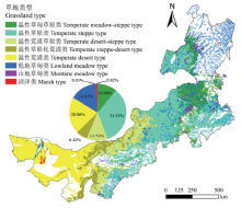
图1
内蒙古草地类型的空间分布及其面积比"

表1
2007年Ts-EVI特征空间干湿边拟合方程"
| 日序Day of year | 干边Dry edge | 湿边 Wet edge |
|---|---|---|
| 2007001 | Tsmax = -82.87x+11.56 (R2=0.83) | Tsmin= 40.12x-34.74 (R2=0.70) |
| 2007017 | Tsmax = -90.54x+15.04 (R2=0.80) | Tsmin= 20.20x-26.08 (R2=0.44) |
| 2007033 | Tsmax = -97.38x+15.04 (R2=0.81) | Tsmin= 33.15x-25.03 (R2=0.74) |
| 2007049 | Tsmax = -145.5x+34.04 (R2=0.85) | Tsmin= 49.65x-26.43 (R2=0.77) |
| 2007065 | Tsmax = -172.65x+37.75 (R2=0.87) | Tsmin= 61.21x-24.82 (R2=0.51) |
| 2007081 | Tsmax = -203.46x+49.17 (R2=0.85) | Tsmin= 31.51x-11.72 (R2=0.43) |
| 2007097 | Tsmax = -148.72x+48.57 (R2=0.90) | Tsmin= 64.58x-11.61 (R2=0.71) |
| 2007113 | Tsmax = -140.01x+56.65 (R2=0.73) | Tsmin= -13.78x+9.54 (R2=0.16) |
| 2007129 | Tsmax = -32.86x+43.75 (R2=0.83) | Tsmin= 41.38x+0.76 (R2=0.78) |
| 2007145 | Tsmax = -42.46x+52.65 (R2=0.92) | Tsmin= -2.33x+20.41 (R2=0.03) |
| 2007161 | Tsmax = -41.11x+56.77 (R2=0.95) | Tsmin=-7.85x+23.16 (R2=0.29) |
| 2007177 | Tsmax = -39.30x+58.04 (R2=0.96) | Tsmin= -5.74x+24.22 (R2=0.13) |
| 2007193 | Tsmax = -36.77x+55.14 (R2=0.95) | Tsmin= -2.93x+20.76 (R2=0.03) |
| 2007209 | Tsmax = -39.59x+58.42 (R2=0.94) | Tsmin= -4.29x+22.52 (R2=0.16) |
| 2007225 | Tsmax = -33.28x+50.68 (R2=0.93) | Tsmin= -11.03x+25.73 (R2=0.45) |
| 2007241 | Tsmax = -39.86x+50.00 (R2=0.93) | Tsmin= 4.31x+16.25 (R2=0.05) |
| 2007257 | Tsmax = -46.32x+44.40 (R2=0.90) | Tsmin= 7.98x+7.82 (R2=0.21) |
| 2007273 | Tsmax = -41.59x+35.04 (R2=0.93) | Tsmin= 52.85x-3.67 (R2=0.69) |
| 2007289 | Tsmax = -110.85x+37.67 (R2=0.90) | Tsmin= 27.34x-9.22 (R2=0.34) |
| 2007305 | Tsmax = -77.21x+23.40 (R2=0.84) | Tsmin= 32.70x-14.35 (R2=0.53) |
| 2007321 | Tsmax = -96.06x+17.73 (R2=0.84) | Tsmin= 36.85x-30.38 (R2=0.71) |
| 2007337 | Tsmax = -78.62x+11.81 (R2=0.85) | Tsmin= 29.30x-30.69 (R2=0.63) |
| 2007353 | Tsmax = -84.95x+14.68 (R2=0.88) | Tsmin= 29.17x-31.44 (R2=0.56) |
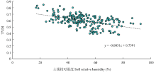
图2
TVDI与表层土壤相对湿度的关系"

表2
TVDI干旱等级划分标准"
| 干旱等级Drought grades | TVDI值TVDI value |
|---|---|
| 重度湿润Severe wetness | 0<TVDI≤0.2 |
| 轻度湿润Mild wetness | 0.2<TVDI≤0.4 |
| 正常Normal state | 0.4<TVDI≤0.6 |
| 轻度干旱Mild drought | 0.6<TVDI≤0.8 |
| 重度干旱Severe drought | 0.8<TVDI≤1.0 |
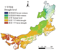
图3
2000-2017年内蒙古草地干旱等级空间分布"
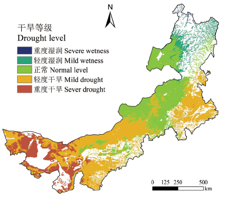

图4
各草地类型不同干旱等级所占面积比 TD-温性荒漠类;TS-温性草原类;TSD-温性草原化荒漠类;TDS-温性荒漠草原类;TMS-温性草甸草原类;LM-低地草甸类;MM-山地草甸类;M-沼泽类"
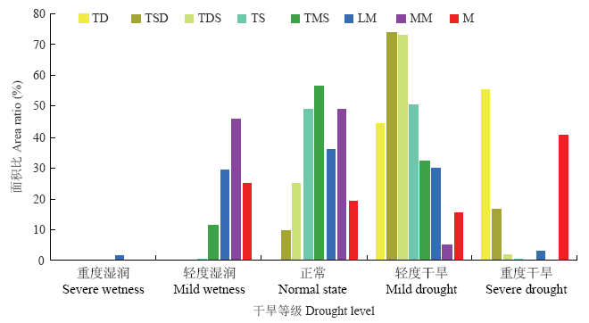

图5
2000-2017年内蒙古草地TVDI年际变化"
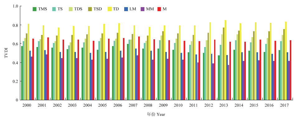
表3
各草地类型TVDI的一元线性回归特征及干旱变化趋势"
| 草地类型 Grassland type | 回归方程 Regression equation | R2 | 显著性 Significance | TVDI趋势 Trend of TVDI | 干旱趋势 Trend of drought |
|---|---|---|---|---|---|
| TMS | y = -0.0036x + 0.5725 | 0.4428 | P<0.01 | 减小 Decrease | 变湿 Wet |
| TDS | y = 0.0026x + 0.6297 | 0.279 | P<0.05 | 增加 Increase | 变干 Dry |
| TSD | y = 0.003x + 0.6846 | 0.4666 | P<0.01 | 增加 Increase | 变干 Dry |
| TD | y = 0.0025x + 0.7812 | 0.4091 | P<0.01 | 增加 Increase | 变干 Dry |
| LM | y = -0.0018x + 0.526 | 0.3518 | P<0.01 | 减小 Decrease | 变湿 Wet |
| MM | y = -0.0036x + 0.4641 | 0.4956 | P<0.01 | 减小 Decrease | 变湿 Wet |
| M | y = -0.0015x + 0.6542 | 0.307 | P<0.05 | 减小 Decrease | 变湿 Wet |
图6
TVDI 16 d间隔(18年均值)变化情况"
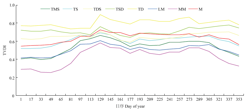

图7
TVDI变化趋势(a)及显著性(b)空间分布"

表4
干旱变化趋势显著性等级划分"
| β | |Zc| | |||
|---|---|---|---|---|
| |Zc|≤1.960 | 1.960<|Zc|≤2.576 | 2.576<|Zc|≤3.291 | |Zc|>3.291 | |
| β≤-0.001 | 稳定不变Stable | 轻微变湿Wet slightly | 变湿Wet | 显著变湿Wet significantly |
| -0.001<β≤0.001 | 稳定不变Stable | 稳定不变Stable | 稳定不变Stable | 稳定不变Stable |
| β>0.001 | 稳定不变Stable | 轻微变干Dry slightly | 变干Dry | 显著变干Dry significantly |
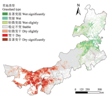
图8
内蒙古自治区2000-2017年干旱详细变化情况空间分布"

表5
不同草地类型中各干旱变化类型所占面积比"
| 变化类型Change type | TMS | TS | TDS | TSD | TD | LM | MM | M |
|---|---|---|---|---|---|---|---|---|
| 显著变湿Wet significantly | 2.83 | 0.33 | 0 | 0 | 0 | 2.23 | 3.54 | 1.12 |
| 变湿Wet | 18.67 | 2.42 | 0.02 | 0 | 0.02 | 10.23 | 17.30 | 7.44 |
| 轻微变湿Wet slightly | 28.44 | 9.39 | 0.04 | 0.02 | 0.04 | 18.58 | 31.77 | 16.93 |
| 稳定不变Stable | 49.98 | 84.02 | 63.43 | 33.93 | 37.98 | 63.68 | 47.37 | 63.02 |
| 轻微变干Dry slightly | 0.07 | 2.91 | 22.17 | 32.38 | 34.13 | 3.61 | 0.02 | 9.91 |
| 变干Dry | 0.01 | 0.84 | 12.32 | 26.50 | 23.50 | 1.30 | 0 | 1.47 |
| 显著变干Dry significantly | 0 | 0.10 | 2.02 | 7.16 | 4.33 | 0.36 | 0 | 0.10 |
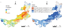
图9
TVDI与降水的相关性(a)及显著性检验(b)"

表6
TVDI与降水的相关性及显著性检验所占的面积比"
| 显著性Significanct | TMS | TS | TDS | TSD | TD | LM | MM | M |
|---|---|---|---|---|---|---|---|---|
| 显著正相关Positive correlation & P<0.05 | 0 | 0 | 0 | 0 | 0.01 | 0.09 | 0.01 | 0.06 |
| 正相关不显著Positive correlation & P>0.05 | 0.55 | 0.53 | 0.26 | 1.10 | 12.27 | 9.26 | 0.85 | 4.25 |
| 显著负相关Negative correlation & P<0.05 | 89.66 | 61.67 | 37.00 | 12.07 | 5.68 | 49.15 | 80.47 | 35.06 |
| 负相关不显著Negative correlation & P>0.05 | 9.79 | 37.80 | 62.74 | 86.83 | 82.04 | 41.50 | 18.67 | 60.63 |
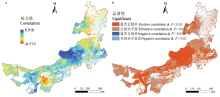
图10
TVDI与温度的相关性(a)及显著性检验(b)"

表7
TVDI与温度的相关性及显著性检验所占的面积比"
| 显著性Significanct | TMS | TS | TDS | TSD | TD | LM | MM | M |
|---|---|---|---|---|---|---|---|---|
| 显著正相关Positive correlation & P<0.05 | 25.00 | 64.47 | 44.60 | 52.48 | 37.37 | 29.95 | 19.69 | 19.87 |
| 正相关不显著Positive correlation & P>0.05 | 73.49 | 35.29 | 53.44 | 45.88 | 61.87 | 65.31 | 77.72 | 78.72 |
| 显著负相关Negative correlation & P<0.05 | 0 | 0 | 0 | 0.01 | 0.02 | 0.01 | 0 | 0 |
| 负相关不显著Negative correlation & P>0.05 | 1.51 | 0.24 | 1.96 | 1.63 | 0.74 | 4.73 | 2.59 | 1.41 |
| [1] | LI Y, HUANG J P, JI M X, RAN J J. Dryland expansion in northern China from 1948 to 2008. Advances in Atmospheric Sciences, 2015,32(6):870-876. |
| [2] | HUANG J P, ZHANG W, ZUO J Q, BI J R, SHI J S, WANG X, CHANG Z L, HUANG Z W, YANG S, ZHANG B D, WANG G Y, FEGN G H, YUAN J Y, ZHANG L, ZUO H C, WANG S G, FU Z B, CHOU J F. An overview of the semi-arid climate and environment research observatory over the Loess Plateau. Advances in Atmospheric Sciences, 2008,25(6):906-921. |
| [3] | PETERSON T C, HOERLING M P, STOTT P A, HERRING S C. Explaining extreme events of 2012 from a climate perspective. Bulletin of the American Meteorological Society, 2013,94(9):S1-S73. |
| [4] | ROHLI R V, BUSHRA N, AM N S, ZOU L, MIHUNOV V, REAMS M A, ARGOTE J E. Drought indices as drought predictors in the south-central USA. Natural Hazards, 2016,83(3):1567-1582. |
| [5] | MCKEE T B, DOESKEN N J, KLEIST J. The relationship of drought frequency and duration to time scales//AMS 8th Conference on Applied Climatology. Anaheim, CA: American Meteorological Society, 1993: 179-184. |
| [6] | PALMER W C. Meteorological Drought. Research Paper No. 45. Washington. DC: United State Department of Commerce, Weather Bureau, 1965:45-58. |
| [7] | VICENTE-SERRANO S M, BEGUERÍA S, LÓPEZ-MORENO J I. A multiscalar drought index sensitive to global warming: the standardized precipitation evapotranspiration index. Journal of Climate, 2010,23(7):1696-1718. |
| [8] | 胡红武, 胡梅, 龙玲, 刘雷. 区域干旱遥感监测研究综述, 安徽农业科学, 2008,36(33):14817-14819. |
| HU H W, HU M, LONG L, LIU L. Research on drought monitoring by remote sensing in attachment. Journal of Anhui Agriculture Science, 2008,36(33):14817-14819. (in Chinese) | |
| [9] | 黄友昕, 刘修国, 沈永林, 刘诗诗, 孙飞. 农业干旱遥感监测指标及其适应性评价方法研究进展. 农业工程学报, 2015,8(16):186-195. |
| HUANG Y X, LIU X G, SHEN Y L, LIU S S, SUN F. Advances in remote sensing derived agricultural drought monitoring indices and adaptability evaluation methods. Transactions of the Chinese Society of Agricultural Engineering, 2015,8(16):186-195. (in Chinese) | |
| [10] | BHUIYAN C, SINGH R P, KOGAN F N. Monitoring drought dynamics in the Aravalli region (India) using different indices based on ground and remote sensing data. International Journal of Applied Earth Observation and Geoinformation, 2006,6(4):289-302. |
| [11] | ANDERSON M C, HAIN C, OTKIN J, ZHAN X W, MO K, SVOBODA M, WARDLOW B, PIMSTEIN A. An intercomparison of drought indicators based on thermal remote sensing and NLDAS-2 simulations with us drought monitor classifications. Journal of Hydrometeorology, 2013,14(4):1035-1056. |
| [12] | ROUSE J W, HAAS R H, SCHELL J A, DEERING D W. Monitoring Vegetation Systems in the Great Plains with ERTS//Proceedings of the Third ERTS-1 Symposium NASA SP-351. Washington DC, 1974: 309-317. |
| [13] | KOGAN F N. Remote sensing of weather impacts on vegetation in non-homogeneous areas. International Journal of Remote Sensing, 1990,11(8):1405-1419. |
| [14] | KOGAN F N. Application of vegetation index and brightness temperature for drought detection. Advances in Space Research, 1995,15(11):91-100. |
| [15] | 王鹏新, 龚健雅, 李小文. 条件植被温度指数及其在干旱监测中的应用. 武汉大学学报(信息科学版), 2001,26(5):412-418. |
| WANG P X, GONG J Y, LI X W. Vegetation-temperature condition index and its application for drought monitoring. Geomatics and Information Science of Wuhan University. 2001,26(5):412-418. (in Chinese) | |
| [16] | SANDHOLT I, RASMUSSEN K, ANDERSEN J. A simple interpretation of the surface temperature/vegetation index space for assessment of surface moisture status. Remote Sensing of Environment, 2002,79(2):213-224. |
| [17] | LIANG L, ZHAO S H, QIN Z H, HE K X, CHEN C, LUO Y X, ZHOU X D. Drought change trend using MODIS TVDI and its relationship with climate factors in China from 2001 to 2010. Journal of Integrative Agriculture, 2014,13(7):1501-1508. |
| [18] | 温国涛, 白建军, 孙嵩松. 基于时间序列遥感数据的陕西省2004-2014年干旱变化特征分析. 干旱地区农业研究, 2018,36(1):221-229. |
| WEN G T, BAI J J, SUN S S. Variation of drought in Shaanxi from 2004 to 2014 based on remotely sensed data. Agricultural Research in the Arid Areas, 2018,36(1):221-229. (in Chinese) | |
| [19] | 托亚. 内蒙古干旱成因及预测研究[D]. 北京: 中国农业科学院学位论文, 2006. |
| TUO Y. Research on the cause of formation and forecast method of draught in Inner Mongolia[D]. Beijing: Chinese Academy of Agriculture Sciences, 2006. (in Chinese) | |
| [20] | 宋春桥, 游松财, 刘高焕, 柯灵红, 钟新科. 基于TVDI的藏北地区土壤湿度空间格局. 地理科学进展, 2011,30(5):569-576. |
| SONG C Q, YOU S C, LIU G H, KE L H, ZHONG X K. The spatial pattern of soil moisture in northern Tibet based on TVDI method. Process in Geography, 2011,30(5):569-576. (in Chinese) | |
| [21] | 杨曦, 武建军, 闫峰, 张洁. 基于地表温度-植被指数特征空间的区域土壤干湿状况. 生态学报, 2009,29(3):1205-1216. |
| YANG X, WU J J, YAN F, ZHANG J. Assessment of regional soil moisture status based on characteristics of surface temperature/ vegetation index space. Acta Ecologica Sinica, 2009,29(3):1205-1216. (in Chinese) | |
| [22] | 毕力格, 银山, 包玉龙, 关彦如. 基于TVDI 的内蒙古植被生长期干旱研究. 安徽农业科学, 2011,39(10):5945-5948. |
| BI L G, YIN S, BAO Y L, GUAN Y R. Research on the drought during the vegetation growth period of Inner Mongolia based on TVDI, Journal of Anhui Agricultural Science, 2011,39(10):5945-5948. (in Chinese) | |
| [23] | 左娇娇. 基于TVDI的内蒙古地区干旱频率时空变换分析. 可持续发展, 2018,295(8):48-50. |
| ZUO J J. Spatiotemporal transformation analysis of drought frequency in Inner Mongolia based on TVDI. Sustainable Development, 2018,295(8):48-50. (in Chinese) | |
| [24] | 内蒙古草地资源编委会. 内蒙古草地资源. 呼和浩特: 内蒙古人民出版社, 1990. |
| Inner Mongolia Grassland Resources Editorial Committee. Grassland Resources of Inner Mongolia. Hohhot: Inner Mongolia People's Publishing House, 1990. (in Chinese) | |
| [25] | HUTCHINSON M F. Anusplin Version 4.3 User Guide. Canberra: The Australia National University, Center for Resource and Environment Studies. 2004. http://cres.anu.edu.au/outputs/anuslin.php. |
| [26] | 刘志红, LI L T, McVICAR T R, Van NIEL T G, 杨勤科, 李锐. 专用气候数据空间插值软件ANUSPLIN及其应用. 气象, 2008,34(2):92-100. |
| LIU Z H, LI L T, McVicar T R, VAN NIEL T G, YANG Q K, LI R. Introduction of the professional interpolation software for meteorology data: ANUSPLINN. Meteorological, 2008,34(2):92-100. (in Chinese) | |
| [27] | 1:1000000中国草地资源图编制委员会. 1:1000000中国草地资源图集, 北京: 中国地图出版社, 1993. |
| 1:1000000 CHINA GRASSLAND RESOURCES MAP COMPILATION COMMITTEE. 1:1000000 Atlas of Grassland Resources in China Beijing: China Map Press. 1993. (in Chinese) | |
| [28] | PRICE J C. Using spatial context in satellite data to infer regional scale evapotranspiration. IEEE Transactions on Geoscience and Remote Sensing, 1990,28(1):940-948. |
| [29] | CARLSON T N, GILLIES R R, PERRY E M. A method to make use of thermal infrared temperature and NDVI measurements to infer surface soil water content and fractional vegetation cover. Remote Sensing Reviews, 1994,9(1):161-173. |
| [30] | NEMANI R R, RUNNING S W. Estimation of regional surface resistance to evapotranspiration from NDVI and Thermal-IR AVHRR data. Journal of Applied Meteorology, 1989,28(4):276-284. |
| [31] | MORAN M S, RAHMAN A F, WASHBURNE J C, GOODRICH D C, WELTZ M A, KUSTAS W P. Combining the Penman-Monteith equation with measurements of surface temperature and reflectance to estimate evaporation rates of semiarid grassland. Agricultural and Forest Meteorology, 1996,80(2):87-109. |
| [32] | CARLSON T N. An overview of the “triangle method” for estimating surface evapotranspiration and soil moisture from satellite imagery. Sensors, 2007,7:1612-1629. |
| [33] | 齐述华, 王长耀, 牛铮. 利用温度植被旱情指数(TVDI)进行全国旱情监测研究. 遥感学报, 2003,7(5):420-427. |
| QI S H, WANG C Y, NIU Z. Evaluating soil moisture status in China using the temperature/vegetation dryness index (TVDI). Journal of Remote Sensing, 2003,7(5):420-427. (in Chinese) | |
| [34] | 姚春生, 张增祥, 汪潇. 使用温度植被干旱指数法(TVDI)反演新疆土壤湿度. 遥感技术与应用, 2004,19(6):473-478. |
| YAO C S, ZHANG Z X, WANG X. Evaluating soil moisture status in Xinjiang using the temperature vegetation dryness index (TVDI), Remote Sensing Technology and Application, 2004,19(6):473-478. (in Chinese) | |
| [35] | 刘英, 岳辉, 侯恩科. MODIS 数据在陕西省干旱监测中的应用. 国土资源遥感, 2019,31(2):172-179. |
| LIU Y, YUE H, HOU E K. Drought monitoring based on MODIS in Shaanxi. Remote Sensing for Land and Resources, 2019,31(2):172-179. (in Chinese) | |
| [36] | 刘馨, 宋小宁, 冷佩, 夏龙. 基于MODIS数据的黄河源区土壤干湿状况时空格局变化. 中国科学院大学学报, 2019,36(2):178-187. |
| LIU X, SONG X N, LENG P, XIA L. Spatiotemporal variation of drought conditions based on MODIS data over the source area of Yellow River. Journal of University of Chinese Academy of Sciences, 2019,36(2):178-187. (in Chinese) | |
| [37] | HUETE A, DIDAN K, VAN LEEUWEN W, VERMOTE E. Global-scale analysis of vegetation indices for moderate resolution monitoring of terrestrial vegetation. Remote Sensing for Earth Science, Ocean, and Sea Ice Applications, 1999,3868:141-151. |
| [38] | HUETE A, DIDAN K, MIURA T, RODRIGUEZ E P, GAO X, FERREIRA L G. Overview of the radiometric and biophysical performance of the MODIS vegetation indices. Remote Sensing of Environment, 2002,83(1):195-213. |
| [39] | CAI B F, YU R. Advance and evaluation in the long time series vegetation trends research based on remote sensing. Journal of Remote Sensing, 2009,13(6):1170-1186. |
| [40] | TUCKER C J, NEWCOMB W W, LOS S O, PRINCE S D. Mean and inter-year variation of growing-season normalized difference vegetation index for the Sahel 1981-1989. International Journal of Remote Sensing, 1991,12(6):1133-1135. |
| [41] | MILICH L, WEISS E. GAC NDVI inter annual coefficient of variation (CoV) images: ground truth sampling of the Sahel along north-south transects. International Journal of Remote Sensing, 2000,21(2):235-260. |
| [42] | LUNETTA R S, KNIGHT J F, EDIRIWICKREMA J, LYON J G, WORTHY L D. Land-cover change detection using multi-temporal MODIS NDVI data. Remote Sensing of Environment, 2006,105(2):142-154. |
| [43] | 袁丽华, 蒋卫国, 申文明, 刘颖慧, 王文杰, 陶亮亮, 郑华, 刘孝富. 2000-2010年黄河流域植被覆盖的时空变化. 生态学报, 2013,33(24):7798-7806. |
| YUAN L H, JIANG W G, SHEN W M, LIU Y H, WANG W J, TAO L L, ZHENG H, LIU X F. The spatio-temporal variations of vegetation cover in the Yellow River Basin from 2000 to 2010. Acta Ecologica Sinaca,2013,33(24):7798-7806. (in Chinese) | |
| [44] | 戴声佩, 张勃, 王海军, 王亚敏, 郭玲霞, 王兴梅, 李丹. 中国西北地区植被覆盖变化驱动因子分析. 干旱区地理, 2010,33(4):636-643. |
| DAI S H, ZHANG B, WANG H J, WANG Y M, GUO L X, WANG X M, LI D. Vegetation cover change and its driving factors over northwest China. Arid Land Geography, 2010,33(4):636-643. (in Chinese) | |
| [45] | THEIL H. A rank-invariant method of linear and polynomial regression analysis. I, II and III// Proceedings of Koninklijke Nederlandse Akademie van Wetenschappen, Series A Mathematical Sciences, 1950,53:386-392,521-525,1397-1412. |
| [46] | SEN P K. Estimates of the regression coefficient based on Kendall' s tau. Journal of the American Statistical Association, 1968,63(324):1379-1389. |
| [47] | HOAGLIN D C, MOSTELLER F, TUKEY J W. Understanding Robust and Exploratory Data Analysis. New York: Wiley, 2000, 169-181. |
| [48] | KENDALL M G. Rank Correlation Methods. London: Griffin, 1975. |
| [49] | TOŠIĆ I. Spatial and temporal variability of winter and summer precipitation over Serbia and Montenegro. Theoretical and Applied Climatology, 2004,77(1/2):47-56. |
| [50] | MANN H B. Noparametric tests against trend. Econometrica, 1945,3(3):245-259. |
| [51] | GOETZ S J. Multi-sensor analysis of NDVI, surface temperature and biophysical variables at a mixed grassland site. International Journal of Remote Sensing, 1997,18(1):71-94. |
| [52] | 王纯枝, 毛留喜, 何延波, 韩丽娟, 陈健, 宇振荣. 温度植被干旱指数法(TVDI)在黄淮海平原土壤湿度反演中的应用研究. 土壤通报, 2009,40(5):998-1005. |
| WANG C Z, MAO L X, HE Y B, HAN L J, CHEN J, YU Z R. Application of temperature-vegetation dryness index (TVDI) in estimation of soil moisture in the Huanghuaihai Plain. Chinese Journal of Soil Science, 2009,40(5):998-1005. (in Chinese) | |
| [53] | ALTMAN D G, BLAND J M. How to obtain the confidence interval from a P value. British Medical Journal, 2011,343(Aug08 1):d2090-d2090. |
| [1] | 冯子恒,宋莉,张少华,井宇航,段剑钊,贺利,尹飞,冯伟. 基于无人机多光谱和热红外影像信息融合的小麦白粉病监测[J]. 中国农业科学, 2022, 55(5): 890-906. |
| [2] | 黄翀,侯相君. 基于Bi-LSTM模型的时间序列遥感作物分类研究[J]. 中国农业科学, 2022, 55(21): 4144-4157. |
| [3] | 陈绪昊,高强,陈新平,张务帅. 东北三省玉米生产资源投入和环境效应的时空特征[J]. 中国农业科学, 2022, 55(16): 3170-3184. |
| [4] | 李美炫,朱西存,白雪源,彭玉凤,田中宇,姜远茂. 基于无人机影像阴影去除的苹果树冠层氮素含量遥感反演[J]. 中国农业科学, 2021, 54(10): 2084-2094. |
| [5] | 史丰智,王瑞燕,李玉环,闫宏,张晓鑫. LAI无人机多光谱遥感估测及其在盐渍土改良中的应用[J]. 中国农业科学, 2020, 53(9): 1795-1805. |
| [6] | 赵静,李志铭,鲁力群,贾鹏,杨焕波,兰玉彬. 基于无人机多光谱遥感图像的玉米田间杂草识别[J]. 中国农业科学, 2020, 53(8): 1545-1555. |
| [7] | 朱晓昱,徐大伟,辛晓平,沈贝贝,丁蕾,王旭,陈宝瑞,闫瑞瑞. 1992—2015年呼伦贝尔草原区不同草地类型分布时空变化遥感分析[J]. 中国农业科学, 2020, 53(13): 2715-2727. |
| [8] | 张晓丽,张宏媛,卢闯,逄焕成,靳存旺,高喜,程挨平,李玉义. 河套灌区不同秋浇年限对土壤细菌群落的影响[J]. 中国农业科学, 2019, 52(19): 3380-3392. |
| [9] | 崔许锋,马云梦,张光宏. 基于模型集成的中国耕地非农化影响因素及其时空特征研究[J]. 中国农业科学, 2018, 51(22): 4316-4327. |
| [10] | 刘志娟,杨晓光,吕硕,王静,LIN XiaoMao. 东北三省春玉米产量差时空分布特征[J]. 中国农业科学, 2017, 50(9): 1606-1616. |
| [11] | 刘焕军,于胜男,张新乐,郭栋,殷继先. 一年一季农作物遥感分类的时效性分析[J]. 中国农业科学, 2017, 50(5): 830-839. |
| [12] | 陈智芳,宋妮,王景雷,孙景生. 基于高光谱遥感的冬小麦叶水势估算模型[J]. 中国农业科学, 2017, 50(5): 871-880. |
| [13] | 张潇元,张立福,张霞,王树东,田静国,翟涌光. 不同光谱植被指数反演冬小麦叶氮含量的敏感性研究[J]. 中国农业科学, 2017, 50(3): 474-485. |
| [14] | 李建军,徐明岗,辛景树,段建军,任意,李冬初,黄晶,申华平,张会民. 中国稻田土壤基础地力的时空演变特征[J]. 中国农业科学, 2016, 49(8): 1510-1519. |
| [15] | 胡兴国,宋雯雯,魏云山,孙宾成,李强,柴燊,孙如建,邵玉彬,任珂,丁素荣,吴存祥,武婷婷,张万海,韩天富. 内蒙古自治区大豆品种生育期分组及种植区划[J]. 中国农业科学, 2016, 49(2): 260-271. |
|
||