


中国农业科学 ›› 2026, Vol. 59 ›› Issue (9): 1916-1936.doi: 10.3864/j.issn.0578-1752.2026.09.007
邓春秀1( ), 姚莉2, 武鸿剑1, 李杰1, 沈悦1, 赖明1, 喻龙1, 郭伟1, 李瑾萌1, 林超文2, 李源洪1()
收稿日期:2025-06-07
接受日期:2025-08-26
出版日期:2026-05-01
发布日期:2026-05-06
通信作者:
联系方式:
邓春秀,E-mail:13540890186@163.com。
基金资助:
DENG ChunXiu1(), YAO Li2, WU HongJian1, LI Jie1, SHEN Yue1, LAI Ming1, YU Long1, GUO Wei1, LI JinMeng1, LIN ChaoWen2, LI YuanHong1()
Received:2025-06-07
Accepted:2025-08-26
Published:2026-05-01
Online:2026-05-06
摘要:
【目的】探明长江上游典型丘陵区四川省遂宁市1986—2035年土地利用变化与碳储量的相关性,揭示区域“耕地保护-生态保护-碳汇”协同路径,为科学合理地促进碳储量提升和维持农业可持续发展提供理论依据。【方法】基于1986—2023年遥感解译土地利用数据,运用InVEST模型计算各时期碳储量,耦合地理探测器与岭回归解析空间分异驱动因子,结合PLUS模型模拟自然发展(NDS)、城镇发展(UDS)、生态优先(EPS)和耕地保护(CPS)4种情景下2035年土地利用与碳储量变化,探讨遂宁市近40年来碳储量的变化趋势及影响因素。【结果】(1)土地利用转型特征。近40年来,耕地、林地及建设用地面积变化显著,土地利用呈现“耕地收缩—城镇扩张—生态修复”三阶段演化。耕地占比从66.6%降至46.1%,建设用地扩张超1倍,从6.0%增加至13.4%,耕地转林地(56.3%)为主要转化路径。(2)碳储量双向效应。区域碳储量净增28.73×10⁵ t,其中耕地转林地是驱动碳储量增加的最重要因子,其贡献核心碳汇增量113.16×10⁵ t,其次为耕地转灌木,增储13.13×10⁵ t,而建设用地扩张导致碳损失14.90×10⁵ t;碳储量结构以土壤有机碳为主,其占比达84.0%以上。(3)驱动因素。地形-植被协同效应主导碳储量空间分异,植被指数(土壤调解植被指数、归一化植被指数、叶面积指数)贡献率超62.0%;地形因子因丘陵变异有限(坡度变异系数CV≤0.38)呈现“高q值-低贡献”悖离(实际贡献率<7.0%)。(4)情景预测。生态优先情景(EPS)为最大碳汇储量最优路径,碳储量微增0.2%,通过建设用地严控(增加2.2%)和林草协同修复(草地增加69.9%)实现;耕地保护情景(CPS)引发生态风险,虽耕地增加11.6%,但碳储量下降0.1%,且湿地转化率近50.0%。【结论】综合考虑近40年土地利用变化对碳储量的影响及其驱动因素,优化土地利用结构、推行“分区调控”策略,是促进川中丘陵区碳储量稳步提升的关键路径。
邓春秀, 姚莉, 武鸿剑, 李杰, 沈悦, 赖明, 喻龙, 郭伟, 李瑾萌, 林超文, 李源洪. 基于近40年土地利用变化的川中丘陵区碳储量时空演变与驱动因素分析[J]. 中国农业科学, 2026, 59(9): 1916-1936.
DENG ChunXiu, YAO Li, WU HongJian, LI Jie, SHEN Yue, LAI Ming, YU Long, GUO Wei, LI JinMeng, LIN ChaoWen, LI YuanHong. Spatio-Temporal Evolution and Driving Factors of Carbon Storage in Hilly Areas in Central Sichuan Based on Land Use Change in the Past 40 Years[J]. Scientia Agricultura Sinica, 2026, 59(9): 1916-1936.
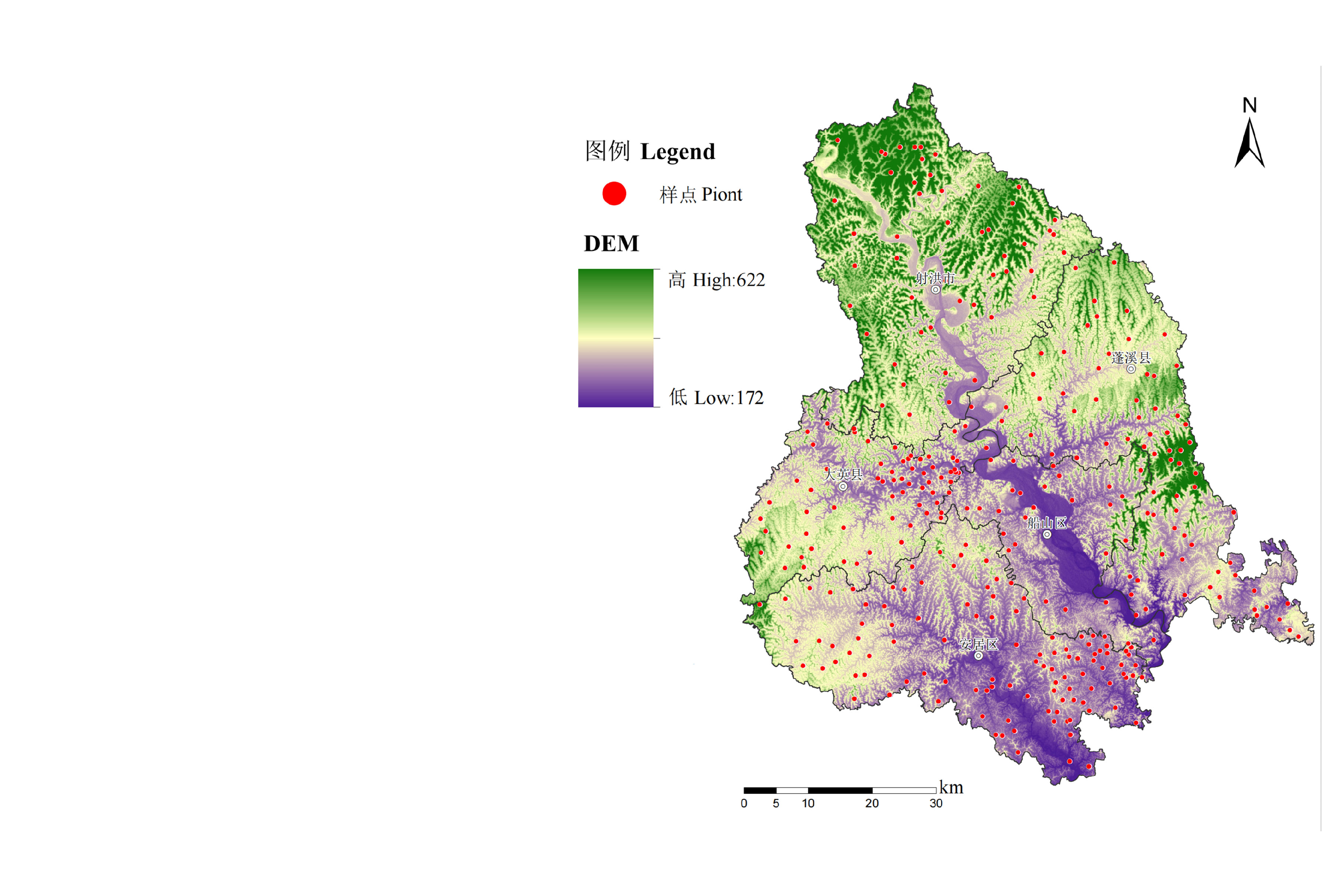
图1
研究区样点分布图"
表1
模型驱动因子数据来源与说明"
| 数据类别 Data category | 数据名称 Data name | 时间 Year | 分辨率 Resolution (m) | 数据来源 Data source |
|---|---|---|---|---|
| 地形因子 Topographic factor | 海拔高度DEM | 30 | OpenTopography_Copernicus GLO-30 Digital Elevation Model | |
| 坡度SLP | 1986, 2009, 2019, 2023 | 30 | ||
| 山谷深度VD | 30 | |||
| 植被指数 Vegetation index | 归一化植被指数NDVI | 30 | 中国陆地观测卫星(Landsat)( Calculated and analyzed by China Land Observation Satellite (Landsat) | |
| 叶面积指数LAI | 30 | |||
| 增强植被指数EVI | 30 | |||
| 土壤调解植被指数SAVI | 30 | |||
| 地表水分指数LSWI | 30 | |||
| 修正型归一化差异水体指数MNDWI | 30 | |||
| 土壤增强指数SER1 | 30 | |||
| 土壤增强指数SER2 | 30 | |||
| 土壤增强指数SER3 | 30 | |||
| 气候因子 Climatic factor | 年平均气温TEM | 1000 | 中国1 km分辨率逐月平均气温数据集(1901—2023) Monthly mean temperature dataset at 1km resolution for China (1901-2023) | |
| 年平均降水PRE | 1000 | 中国1 km分辨率逐月降水量数据集(1901—2023) Monthly precipitation dataset at 1 km resolution for China (1901 -2023) | ||
| 社会因子 Social factor | 人口数据POP | 2000, 2010, 2015, 2020 | 1000 | 中国人口空间分布公里网格数据集 China Population Spatial Distribution Kilometer Grid Dataset |
| 距道路距离ROAD | 1986, 2009, 2019, 2023 | 30 | 根据土地利用提取后,数据计算生成 After extraction based on land use, the data is computationally generated |
表2
遂宁市各地类碳密度"
| 土地利用类型 Land use/Land cover type | 地上生物量碳密度 Aboveground biomass carbon density | 地下生物量碳密度 Belowground biomass carbon density | 土壤有机碳密度(校正) Soil organic carbon density | 死亡有机质碳密度 Dead organic matter carbon density |
|---|---|---|---|---|
| 耕地Cultivated land | 4.02 | 0.75 | 91.33 | 2.11 |
| 林地Forest land | 22.62 | 18.03 | 125.77 | 2.78 |
| 灌木Shrubland | 8.67 | 4.05 | 84.78 | 0.87 |
| 草地Grassland | 3.60 | 11.70 | 65.93 | 7.28 |
| 水域Water area | 1.59 | 0.00 | 67.53 | 3.98 |
| 湿地Wetland | 2.10 | 6.82 | 56.17 | 0.21 |
| 建设用地 Construction land | 0.83 | 0.08 | 43.71 | 0.00 |
| 未利用地Unused land | 0.59 | 0.64 | 28.42 | 0.96 |
表3
不同情景土地利用转移矩阵设置"
| LUCC类型 LUCC type | 自然发展情景 Natural development scenario | 城市发展情景 Urban development scenario | 生态优先情景 Ecological priority scenario | 耕地保护情景 Farmland protection scenario | ||||||||||||||||||||||||||||
|---|---|---|---|---|---|---|---|---|---|---|---|---|---|---|---|---|---|---|---|---|---|---|---|---|---|---|---|---|---|---|---|---|
| a | b | c | d | e | f | g | h | a | b | c | d | e | f | g | h | a | b | c | d | e | f | g | h | a | b | c | d | e | f | g | h | |
| a | 1 | 1 | 1 | 1 | 1 | 1 | 1 | 1 | 1 | 1 | 1 | 1 | 1 | 1 | 1 | 1 | 1 | 1 | 1 | 1 | 1 | 1 | 1 | 1 | 1 | 0 | 0 | 0 | 0 | 0 | 0 | 0 |
| b | 1 | 1 | 1 | 1 | 1 | 1 | 1 | 1 | 0 | 1 | 0 | 0 | 0 | 0 | 0 | 0 | 1 | 1 | 0 | 1 | 1 | 1 | 0 | 0 | 1 | 1 | 1 | 1 | 1 | 1 | 1 | 1 |
| c | 1 | 1 | 1 | 1 | 1 | 1 | 1 | 1 | 0 | 0 | 1 | 0 | 0 | 0 | 0 | 0 | 0 | 0 | 1 | 0 | 0 | 0 | 0 | 0 | 1 | 0 | 1 | 0 | 0 | 0 | 1 | 0 |
| d | 1 | 1 | 1 | 1 | 1 | 1 | 1 | 1 | 1 | 1 | 1 | 1 | 1 | 1 | 1 | 0 | 0 | 0 | 0 | 1 | 1 | 1 | 0 | 1 | 1 | 1 | 1 | 1 | 1 | 1 | 1 | 1 |
| e | 1 | 1 | 1 | 1 | 1 | 1 | 1 | 1 | 1 | 1 | 1 | 1 | 1 | 1 | 1 | 0 | 0 | 0 | 0 | 1 | 1 | 1 | 0 | 1 | 1 | 1 | 1 | 1 | 1 | 1 | 1 | 1 |
| f | 1 | 1 | 1 | 1 | 1 | 1 | 1 | 1 | 1 | 1 | 1 | 1 | 1 | 1 | 1 | 0 | 0 | 0 | 0 | 1 | 1 | 1 | 0 | 1 | 1 | 1 | 1 | 1 | 1 | 1 | 1 | 1 |
| g | 1 | 1 | 1 | 1 | 1 | 1 | 1 | 1 | 1 | 0 | 1 | 0 | 0 | 1 | 1 | 0 | 1 | 0 | 1 | 1 | 1 | 1 | 1 | 0 | 1 | 1 | 1 | 1 | 1 | 1 | 1 | 1 |
| h | 1 | 1 | 1 | 1 | 1 | 1 | 1 | 1 | 1 | 1 | 1 | 1 | 1 | 1 | 1 | 1 | 1 | 1 | 1 | 1 | 1 | 1 | 1 | 1 | 1 | 1 | 1 | 1 | 1 | 1 | 1 | 1 |
表4
1986—2023年遂宁市土地利用/土地覆盖(LUCC)面积变化"
| LUCC类型 LUCC type | 1986-2009 | 2009-2019 | 2019-2023 | 1986-2023 | ||||
|---|---|---|---|---|---|---|---|---|
| 面积 Area (hm2) | 变幅 Variation (%) | 面积 Area (hm2) | 变幅 Variation (%) | 面积 Area (hm2) | 变幅 Variation (%) | 面积 Area (hm2) | 变幅 Variation (%) | |
| 草地Grassland | -3575.30 | -71.8 | -104.82 | -7.5 | 890.05 | 68.5 | -2790.07 | -56.0 |
| 耕地Cultivated land | -27805.54 | -7.9 | -79926.70 | -24.5 | -1274.11 | -0.5 | -109006.34 | -30.8 |
| 灌木Shrubland | -5627.45 | -97.3 | 26986.71 | 16949.3 | -2026.81 | -7.5 | 19332.46 | 334.1 |
| 建设用地Construction land | 29327.39 | 91.9 | 5152.97 | 8.4 | 4728.70 | 7.1 | 39209.06 | 122.8 |
| 林地Forest land | 21861.79 | 22.5 | 43985.20 | 37.0 | -3479.77 | -2.1 | 62367.22 | 64.2 |
| 湿地Wetlands | -719.09 | -16.0 | -2567.37 | -67.9 | -337.21 | -27.8 | -3623.68 | -80.5 |
| 水域Water area | -7439.46 | -27.2 | 6565.33 | 32.9 | 1495.62 | 5.6 | 621.49 | 2.3 |
| 未利用地Unused land | -6022.35 | -98.4 | -91.32 | -93.2 | 3.53 | 52.7 | -6110.14 | -99.8 |

图2
遂宁市1986(a)、2009(b)、2019(c)、2023(d)年土地利用现状图"

图3
土地利用类型转移矩阵示意图"

图4
遂宁市1986、2009、2019和2023年碳密度空间分布图"
表5
1986—2023年遂宁市碳储量"
| 年 Year | 碳储量 Carbon stock | 地上生物量碳 Above-ground biomass carbon | 地下生物量碳 Below-ground biomass carbon | 土壤有机碳 Soil organic carbon | 死亡有机质碳 Dead organic matter carbon | ||||
|---|---|---|---|---|---|---|---|---|---|
| 含量 Quantity contained (×105 t) | 含量 Quantity contained (×105 t) | 占比 Percentage (%) | 含量 Quantity contained (×105 t) | 占比 Percentage (%) | 含量 Quantity contained (×105 t) | 占比 Percentage (%) | 含量 Quantity contained (×105 t) | 占比 Percentage (%) | |
| 1986 | 561.64 | 37.74 | 6.7 | 21.37 | 3.8 | 490.78 | 87.4 | 11.75 | 2.1 |
| 2009 | 567.96 | 41.03 | 7.2 | 24.39 | 4.3 | 491.43 | 86.5 | 11.11 | 2.0 |
| 2019 | 595.73 | 50.19 | 8.4 | 32.63 | 5.5 | 501.78 | 84.2 | 11.13 | 1.9 |
| 2023 | 590.37 | 49.27 | 8.3 | 32.00 | 5.4 | 498.00 | 84.4 | 11.11 | 1.9 |
表6
1986—2023年遂宁市各地类碳储量变化"
| LUCC类型 LUCC type | 1986-2009 | 2009-2019 | 2019-2023 | 1986-2023 | ||||
|---|---|---|---|---|---|---|---|---|
| 变化量 Variation (×105 t) | 变幅 Variation (%) | 变化量 Variation (×105 t) | 变幅 Variation (%) | 变化量 Variation (×105 t) | 变幅 Variation (%) | 变化量 Variation (×105 t) | 变幅 Variation (%) | |
| 草地Grassland | -3.16 | -71.8 | -0.09 | -7.5 | 0.79 | 68.5 | -2.47 | -56.0 |
| 耕地Cultivated land | -27.31 | -7.9 | -78.50 | -24.5 | -1.25 | -0.5 | -107.06 | -30.8 |
| 灌木Shrubland | -5.54 | -97.3 | 26.55 | 16949.3 | -1.99 | -7.5 | 19.02 | 334.1 |
| 建设用地Construction land | 13.09 | 91.9 | 2.30 | 8.4 | 2.11 | 7.1 | 17.50 | 122.8 |
| 林地Grassland | 36.99 | 22.5 | 74.42 | 37.0 | -5.89 | -2.1 | 105.53 | 64.2 |
| 湿地Wetland | -0.47 | -16.0 | -1.68 | -67.9 | -0.22 | -27.8 | -2.37 | -80.5 |
| 水域Water area | -5.44 | -27.2 | 4.80 | 32.9 | 1.09 | 5.6 | 0.45 | 2.3 |
| 未利用地Unused land | -1.84 | -98.4 | -0.03 | -93.2 | 0.00 | 52.7 | -1.87 | -99.8 |
| 合计Total | 6.32 | 1.1 | 27.78 | 4.9 | -5.36 | -0.9 | 28.73 | 5.1 |
表7
遂宁市1986—2023年各地类变化与碳储量变化矩阵"
| 面积转移矩阵Area transfer matrix (hm2) | |||||||||
|---|---|---|---|---|---|---|---|---|---|
| LUCC类型 LUCC type | 草地 Grassland | 耕地 Cultivated land | 灌木 Shrubland | 建设用地 Construction land | 林地 Forest land | 湿地 Wetland | 水域 Water area | 未利用地 Unused land | 转出 Transfer out |
| 草地Grassland | 539.16 | 818.32 | 153.68 | 268.30 | 3121.70 | 7.50 | 71.25 | 0.08 | 4440.84 |
| 耕地Cultivated land | 1020.77 | 226682.98 | 14749.15 | 37641.09 | 71907.59 | 34.72 | 2326.01 | 0.40 | 127679.73 |
| 灌木Shrubland | 29.51 | 1398.53 | 2054.02 | 229.25 | 1978.68 | 0.00 | 96.67 | 0.00 | 3732.65 |
| 建设用地Construction land | 39.47 | 4250.35 | 382.73 | 24603.99 | 2088.16 | 4.79 | 556.47 | 0.70 | 7322.68 |
| 林地Forest land | 308.89 | 5028.28 | 7080.07 | 4606.49 | 79179.66 | 14.82 | 966.57 | 1.88 | 18007.00 |
| 湿地Wetland | 41.60 | 1210.99 | 34.58 | 728.93 | 170.48 | 546.18 | 1766.84 | 0.03 | 3953.46 |
| 水域Water area | 77.89 | 2438.18 | 140.71 | 1252.80 | 1038.97 | 267.95 | 22176.29 | 0.55 | 5217.04 |
| 未利用地Unused land | 132.64 | 3528.74 | 524.19 | 1804.87 | 68.65 | 0.00 | 54.71 | 6.57 | 6113.79 |
| 转入Transfer in | 1650.77 | 18673.39 | 23065.10 | 46531.74 | 80374.22 | 329.78 | 5838.54 | 3.65 | / |
| 碳储量转移矩阵 Carbon storage transfer matrix(×105 t) | |||||||||
| LUCC类型 LUCC type | 草地 Grassland | 耕地 Cultivated land | 灌木 Shrubland | 建设用地 Construction land | 林地 Forest land | 湿地 Wetland | 水域 Water area | 未利用地 Unused land | 转出 Transfer out |
| 草地Grassland | 0.00 | -0.20 | 0.12 | 0.10 | 4.76 | -0.02 | 0.00 | -0.04 | 4.72 |
| 耕地Cultivated land | 0.18 | 0.00 | 13.13 | 14.90 | 113.16 | -0.77 | -0.08 | -1.08 | 139.44 |
| 灌木Shrubland | -0.11 | -13.11 | 0.00 | -0.07 | -8.63 | -0.02 | -0.03 | -0.16 | -22.13 |
| 建设用地Construction land | -0.20 | -32.79 | 0.15 | 0.00 | -4.26 | -0.47 | -0.51 | -0.55 | -38.63 |
| 林地Forest land | -2.49 | -65.68 | 5.02 | 1.12 | 0.00 | -0.10 | -0.05 | -0.02 | -62.20 |
| 湿地Wetland | 0.03 | 1.16 | 0.03 | 0.32 | 0.26 | 0.00 | 1.10 | 0.00 | 2.90 |
| 水域Water area | 0.01 | 0.11 | 0.04 | 0.31 | 0.12 | -0.98 | 0.00 | -0.02 | -0.41 |
| 未利用地Unused land | 0.12 | 3.47 | 0.52 | 0.81 | 0.11 | 0.00 | 0.04 | 0.00 | 5.07 |
| 转入Transfer in | -2.46 | -107.04 | 19.01 | 17.49 | 105.52 | -2.36 | 0.47 | -1.87 | / |
表8
1986—2023年遂宁市碳储量空间分异驱动因子探测结果"
| 影响因素Influencing factor | 驱动因子Driving factor | 1986 | 2009 | 2019 | 2023 | ||||||||
|---|---|---|---|---|---|---|---|---|---|---|---|---|---|
| q | β | 贡献率Contribution rate (%) | q | β | 贡献率Contribution rate (%) | q | β | 贡献率Contribution rate (%) | q | β | 贡献率Contribution rate (%) | ||
| 气候因素Climate factors | TEM | 0.084 | 9.587 | 5.7 | 0.036 | 1.196 | 0.1 | 0.049 | 14.006 | 0.5 | 0.044 | 6 | 0.3 |
| PRE | 0.052 | 0.166 | 0.1 | 0.005 | -0.323 | 0.0 | 0.003 | -0.880 | 0.0 | 0.002 | -1.898 | 0.0 | |
| 生物因素Biological factors | NDVI | 0.026 | -170.88 | 30.9 | 0.115 | -53.449 | 11.9 | 0.291 | -43.115 | 9.1 | 0.319 | -24.641 | 7.6 |
| LAI | 0.055 | 51.946 | 20.0 | 0.147 | 45.162 | 12.9 | 0.390 | 46.716 | 13.2 | 0.399 | 28.523 | 11.0 | |
| EVI | 0 | 0.002 | 0.0 | 0.064 | 0.025 | 0.0 | 0.120 | -2.502 | 0.2 | 0.148 | 0.677 | 0.1 | |
| SAVI | 0.035 | 57.120 | 14.3 | 0.070 | 0.195 | 0.1 | 0.143 | -423.848 | 43.9 | 0.152 | -275.299 | 40.2 | |
| 地形因素Topographic factors | DEM | 0.107 | 0.173 | 0.1 | 0.089 | 0.106 | 0.0 | 0.097 | 0.182 | 0.0 | 0.124 | 0.084 | 0.0 |
| SLP | 0.003 | 0.024 | 0.0 | 0.076 | 0.682 | 0.1 | 0.118 | 0.454 | 0.0 | 0.202 | 0.517 | 0.1 | |
| VD | 0.018 | 0.028 | 0.0 | 0.037 | -0.071 | 0.0 | 0.075 | 0.083 | 0.0 | 0.096 | -0.051 | 0.0 | |
| 其他遥感因素Other remote sensing factors | LSWI | 0.015 | -112.032 | 11.6 | 0.025 | -245.289 | 11.8 | 0.128 | 253.776 | 23.6 | 0.147 | 168.803 | 23.9 |
| MNDWI | 0.02 | 29.83 | 4.2 | 0.030 | -141.852 | 8.3 | 0.056 | -86.220 | 3.5 | 0.098 | -65.859 | 6.2 | |
| SER1 | 0.007 | 37.625 | 1.8 | 0.071 | -182.486 | 25.3 | 0.241 | -11.486 | 2.0 | 0.218 | -16.479 | 3.5 | |
| SER2 | 0.024 | -42.286 | 7.1 | 0.040 | 276.297 | 21.2 | 0.037 | 8.487 | 0.2 | 0.075 | 13.126 | 0.9 | |
| SER3 | 0.02 | -29.83 | 4.1 | 0.030 | 141.852 | 8.3 | 0.056 | 86.220 | 3.5 | 0.098 | 65.859 | 6.2 | |
| 社会经济因素Socio-economic factors | POP | 0.026 | -0.001 | 0.0 | 0.028 | -0.012 | 0.0 | 0.026 | 0.002 | 0.0 | 0.025 | 0.001 | 0.0 |
| ROAD | 0.034 | 0.002 | 0.0 | 0.011 | 0 | 0.0 | 0.018 | -0.001 | 0.0 | 0.019 | -0.001 | 0.0 | |
图5
1986(a)、2009(b)、2019(c)、2023(d)年驱动因子岭回归分析结果示意图"

图6
2035年自然发展、城镇发展、生态优先、耕地保护4种情景下的土地利用类型预测图"
表9
2035年4种发展情景下的土地利用/土地覆盖类型预测"
| LUCC类型 LUCC type | 2023年基期年 The base year of 2023 | 2035年自然发展情景 Natural development scenario in 2035 | 2035年城镇发展情景 Urban development scenarios in 2035 | 2035年生态优先情景 Ecological priority scenario in 2035 | 2035年耕地保护情景 Farmland protection scenario in 2035 | |||||||||
|---|---|---|---|---|---|---|---|---|---|---|---|---|---|---|
| 面积 Area (hm2) | 地类占比 Percentage of land types (%) | 面积 Area (hm2) | 地类占比 Percentage of land types (%) | 变幅 Amplitude variation (%) | 面积 Area (hm2) | 地类占比 Percentage of land types (%) | 变幅 Amplitude variation (%) | 面积 Area (hm2) | 地类占比 Percentage of land types (%) | 变幅 Amplitude variation (%) | 面积 Area (hm2) | 地类占比 Percentage of land types (%) | 变幅 Amplitude variation (%) | |
| 耕地Cultivated land | 245356.37 | 46.1 | 240743.52 | 45.2 | -1.9 | 239961.15 | 45.1 | -2.2 | 237923.33 | 44.7 | -3.0 | 273812.13 | 51.4 | 11.6 |
| 建设用地 Construction land | 71135.72 | 13.4 | 84758.67 | 15.9 | 19.1 | 86100.21 | 16.2 | 21.0 | 72716.49 | 13.7 | 2.2 | 61056.54 | 11.5 | -14.2 |
| 水域Water area | 28014.83 | 5.3 | 29112.03 | 5.5 | 3.9 | 29797.83 | 5.6 | 6.4 | 28642.05 | 5.4 | 2.2 | 25280.28 | 4.8 | -9.8 |
| 林地Forest land | 159553.89 | 30.0 | 149852.79 | 28.2 | -6.1 | 149553.36 | 28.1 | -6.3 | 162717.52 | 30.6 | 2.0 | 149867.46 | 28.2 | -6.1 |
| 灌木Shrubland | 25119.12 | 4.7 | 24591.96 | 4.6 | -2.2 | 23608.62 | 4.4 | -6.1 | 26079.3 | 4.9 | 3.8 | 20949.39 | 3.9 | -16.7 |
| 草地Grassland | 2189.93 | 0.4 | 2745 | 0.5 | 25.7 | 2478.33 | 0.5 | 13.4 | 3719.61 | 0.7 | 69.9 | 841.23 | 0.2 | -61.5 |
| 湿地Wetland | 875.96 | 0.2 | 456.03 | 0.1 | -48.0 | 760.41 | 0.1 | -13.2 | 465.12 | 0.1 | -46.9 | 456.48 | 0.1 | -47.9 |
| 未利用地 Unused land | 10.22 | 0.0 | 6.57 | 0.0 | -37.6 | 6.66 | 0.0 | -36.8 | 3.15 | 0.0 | -69.2 | 3.06 | 0.0 | -70.9 |
表10
2035年4种发展情景下的碳储量预测"
| LUCC类型 LUCC type | 2023年基期年 The base year of 2023 | 2035年自然发展情景 Natural development scenario in 2035 | 2035年城镇发展情景 Urban development scenarios in 2035 | 2035年生态优先情景 Ecological priority scenario in 2035 | 2035年耕地保护情景 Farmland protection scenario in 2035 | ||||
|---|---|---|---|---|---|---|---|---|---|
| 碳储量 Carbon stock (×105 t) | 碳储量 Carbon stock (×105 t) | 变幅 Amplitude variation (%) | 碳储量 Carbon stock (×105 t) | 变幅 Amplitude variation (%) | 碳储量 Carbon stock (×105 t) | 变幅 Amplitude variation (%) | 碳储量 Carbon stock (×105 t) | 变幅 Amplitude variation (%) | |
| 耕地Cultivated land | 240.96 | 236.43 | -1.9 | 235.67 | -2.2 | 233.66 | -3.0 | 268.91 | 11.6 |
| 建设用地Construction land | 31.74 | 37.82 | 19.2 | 38.42 | 21.0 | 32.45 | 2.2 | 27.24 | -14.2 |
| 水域Water area | 20.48 | 21.28 | 3.9 | 21.78 | 6.4 | 20.94 | 2.2 | 18.48 | -9.8 |
| 林地Forest land | 269.97 | 253.55 | -6.1 | 253.04 | -6.3 | 275.32 | 2.0 | 253.58 | -6.1 |
| 灌木Shrubland | 24.71 | 24.19 | -2.1 | 23.22 | -6.0 | 25.65 | 3.8 | 20.61 | -16.6 |
| 草地Grassland | 1.94 | 2.43 | 25.4 | 2.19 | 13.2 | 3.29 | 69.9 | 0.74 | -61.6 |
| 湿地Wetland | 0.57 | 0.30 | -47.9 | 0.50 | -13.2 | 0.30 | -46.9 | 0.30 | -47.9 |
| 未利用地Unused land | 0.003 | 0.002 | -35.7 | 0.002 | -34.8 | 0.001 | -69.2 | 0.001 | -70.1 |
| 合计Total | 590.37 | 576.01 | -2.4 | 574.83 | -2.6 | 591.62 | 0.2 | 589.86 | -0.1 |

图7
遂宁市2035年自然发展情景、城镇发展情景、生态优先情景和耕地保护情景下碳密度分布示意图"
表11
四类情景下平均碳密度分布"
| 分区 Partition | 2023基期年 The base year of 2023 | 自然发展情景 Natural development scenario | 城镇发展情景 Urban development scenario | 生态优先情景 Ecological priority scenario | 耕地保护情景 Farmland protection scenario |
|---|---|---|---|---|---|
| 北部低山带 The northern low mountain area | 120.98 | 117.41 | 117.08 | 121.19 | 120.50 |
| 涪江冲积带Fujiang alluvial zone | 80.75 | 78.99 | 78.67 | 81.80 | 81.15 |
| 琼江丘陵带Qiongjiang hilly belt | 111.62 | 109.16 | 108.98 | 111.66 | 111.66 |
| 中心城郊带Central peri-urban belt | 69.51 | 66.58 | 66.41 | 70.39 | 68.68 |
| 合计Total | 110.92 | 108.22 | 108.00 | 111.15 | 110.82 |
| [1] |
doi: 10.1007/s11430-011-4292-0 |
| [2] |
陈宁, 辛存林, 唐道斌, 张亮, 辛顺杰. 中国西北地区多情景土地利用优化与碳储量评估. 环境科学, 2023, 44(8): 4655-4665.
|
|
|
|
| [3] |
doi: 10.1029/96GB02692 |
| [4] |
司晓茜, 王小军, 林莹冰, 刘光旭. 福建省碳储量时空特征及其对土地利用变化的响应. 水土保持通报, 2023, 43(5): 355-364, 394.
|
|
|
|
| [5] |
刘纪远, 于贵瑞, 王绍强, 岳天祥, 高志强. 陆地生态系统碳循环及其机理研究的地球信息科学方法初探. 地理研究, 2003, 22(4): 397-405.
|
|
|
|
| [6] |
杜怀玉, 俞金凤, 张媛, 王家亮. 石羊河流域多情景土地利用优化及碳储量评估. 环境科学, 2024, 45(7): 4164-4176.
|
|
|
|
| [7] |
屈颂杰, 韩玲, 黄馨, 杨楠楠, 郭千慧子. 未来不同情景下陕西省碳储量的时空演变分析. 环境科学, 2024, 45(8): 4683-4695.
|
|
|
|
| [8] |
doi: 10.5814/j.issn.1674-764x.2025.01.013 |
| [9] |
朴世龙, 何悦, 王旭辉, 陈发虎. 中国陆地生态系统碳汇估算: 方法、进展、展望. 中国科学: 地球科学, 2022, 52(6): 1010-1020.
|
|
|
|
| [10] |
薛玮, 徐丽君, 聂莹莹, 吴欣珈, 严翊丹, 叶立明, 柳新伟. 影响呼伦贝尔草原土壤有机碳空间变异的主导因素. 中国农业科学, 2024, 57(12): 2378-2389. doi: 10.3864/j.issn.0578-1752.2024.12.009.
|
|
|
|
| [11] |
李曼, 吴东丽, 何昊, 余慧婕, 赵琳, 刘聪, 胡正华, 李琪. 1990—2020年黄河流域碳储量时空演变及驱动因素研究. 生态环境学报, 2025, 34(3): 333-344.
doi: 10.16258/j.cnki.1674-5906.2025.03.001 |
|
|
|
| [12] |
黄韬, 刘素红. 基于PLUS-InVEST模型的福建省土地利用变化与碳储量评估. 水土保持学报, 2024, 38(2): 246-257.
|
|
doi: 10.1080/00224561.1983.12436295 |
|
| [13] |
doi: 10.1016/j.ecolind.2022.109178 |
| [14] |
孙严超, 王伟业, 刘道垒, 蔡俊. 基于LUCC的河南省碳储量时空演变与驱动因素分析. 水土保持研究, 2025, 32(4): 266-278.
|
|
|
|
| [15] |
陈大蓉, 周旭, 杨胜天, 裴宇, 胡玉雪, 胡锋. 基于贵州省土地变化的碳储量演变及其脆弱性特征分析. 水土保持通报, 2023, 43(3): 301-309.
|
|
|
|
| [16] |
王双, 赵晓, 周生辉. 未来多情景土地利用变化对河南省区域碳储量的影响. 环境科学, 2025, 46(6): 3830-3845.
|
|
|
|
| [17] |
田梓祎, 高凡, 何兵, 韩方红. 1990—2020年塔里木河流域土地利用变化及其对碳储量的影响. 环境科学, 2024, 45(11): 6514-6526.
|
|
|
|
| [18] |
傅楷翔, 贾国栋, 余新晓, 陈立欣. 耦合PLUS-InVEST-Geodector模型的新疆地区碳储量时空变化及驱动机制分析. 环境科学, 2024, 45(9): 5416-5430.
|
|
|
|
| [19] |
doi: 10.1016/j.ecolind.2022.108828 |
| [20] |
陈红香, 辛存林, 陈宁, 马新淑, 白元, 康利刚, 辛顺杰. 基于PLUS-InVEST模型的川渝地区碳储量变化及多情景预测. 环境科学, 2026, 47(1): 360-371.
|
|
|
|
| [21] |
贾天朝, 胡西武. 基于PLUS-InVEST-Geodector模型的三江源国家公园碳储量时空变化及驱动力. 环境科学, 2024, 45(10): 5931-5942.
|
|
|
|
| [22] |
林彤, 杨木壮, 吴大放, 刘锋, 杨金海, 王颖佳. 基于InVEST- PLUS模型的碳储量空间关联性及预测: 以广东省为例. 中国环境科学, 2022, 42(10): 4827-4839.
|
|
|
|
| [23] |
蔡博峰, 朱松丽, 于胜民, 董红敏, 张称意, 王长科, 朱建华, 高庆先, 方双喜, 潘学标, 郑循华. 《IPCC 2006年国家温室气体清单指南2019修订版》解读. 环境工程, 2019, 37(8): 1-11.
|
|
|
|
| [24] |
doi: 10.1016/j.worlddev.2016.06.013 |
| [25] |
国务院第三次全国土壤普查领导小组办公室. 国务院第三次全国土壤普查领导小组办公室调研座谈第三次全国土壤普查技术规程规范验证情况. 中国农业综合开发, 2023(6): 62.
|
|
The Office of the Leading Group for the Third National Soil Survey in the State Council. The Office of the Leading Group for the Third National Soil Survey in the State Council conducted an investigation and discussion on the verification of the technical specifications of the third national soil survey. Agricultural Comprehensive Development in China, 2023(6): 62. (in Chinese)
|
|
| [26] |
于卓璇, 刘钺. 基于PLUS和InVEST模型的湘江流域碳储存时空演变及多情景预测. 农业资源与环境学报, 2026, 43(2): 355-365.
|
|
|
|
| [27] |
于晓燕, 商亚男, 魏光普, 张舒宇, 吴健. 基于PLUS-InVEST模型的国家级稀土矿区土地利用变化与碳储量预测研究. 沈阳农业大学学报, 2025, 56(6): 153-164.
|
|
|
|
| [28] |
doi: 10.1080/13658816.2018.1502441 |
| [29] |
doi: 10.1016/j.compenvurbsys.2020.101569 |
| [30] |
doi: 10.3390/rs13071307 |
| [31] |
马玉洁, 李旭, 翟英芳, 李敬宇, 付鑫, 彭正萍. 秸秆还田方式和施氮量对土壤有机碳组分及酶活性的影响. 中国农业科学, 2025, 58(12): 2397-2410. doi: 10.3864/j.issn.0578-1752.2025.12.010.
|
|
|
| [1] | 郭戎博, 李国栋, 潘梦雨, 郑险峰, 王朝辉, 何刚. 秸秆还田与施氮对耕层土壤有机碳储量、组分和团聚体的影响[J]. 中国农业科学, 2023, 56(20): 4035-4048. |
| [2] | 辛晓平,丁蕾,程伟,朱晓昱,陈宝瑞,刘钟龄,何广礼,青格勒,杨桂霞,唐华俊. 北方草地及农牧交错区草地植被碳储量及其影响因素[J]. 中国农业科学, 2020, 53(13): 2757-2768. |
| [3] | 王鸣雷,史文娇. 中国北方新增耕地的时空变化及驱动因素分区[J]. 中国农业科学, 2020, 53(12): 2435-2449. |
| [4] | 齐玉春1, 郭树芳1, 2, 董云社1, 彭琴1, 贾军强1, 2, 曹丛丛1, 2, 孙良杰1, 2, 闫钟清1, 2, 贺云龙1, 2. 灌溉对农田温室效应贡献及土壤碳储量影响研究进展[J]. 中国农业科学, 2014, 47(9): 1764-1773. |
| [5] | 萨茹拉1, 李金祥2, 侯向阳1. 草地生态系统土壤有机碳储量及其分布特征[J]. 中国农业科学, 2013, 46(17): 3604-3614. |
| [6] | 杜章留, 任图生, 胡春胜. 保护性耕作对太行山前平原土壤热水解和酸解有机碳的影响[J]. 中国农业科学, 2013, 46(11): 2249-2256. |
| [7] | 刘 琦,任志远,李 晶. 区域土地利用变化图谱分析及其生态效应评价 ——以太原市城区及近郊区为例[J]. 中国农业科学, 2007, 40(10): 2259-2266 . |
| [8] | 姜勇. 潮棕壤不同利用方式有机碳剖面分布及碳储量[J]. 中国农业科学, 2005, 38(03): 544-550 . |
|
||