






中国农业科学 ›› 2026, Vol. 59 ›› Issue (10): 2194-2213.doi: 10.3864/j.issn.0578-1752.2026.10.010
丁晓颖1,3( ), 蔡艳蓉2, 宋敏2, 金大卫3(), 曹春霞1
收稿日期:2025-07-01
接受日期:2025-08-11
出版日期:2026-05-16
发布日期:2026-05-20
通信作者:
联系方式:
丁晓颖,E-mail:dingxiaoying@zuel.edu.cn。
基金资助:
DING XiaoYing1,3(), CAI YanRong2, SONG Min2, JIN DaWei3(), CAO ChunXia1
Received:2025-07-01
Accepted:2025-08-11
Published:2026-05-16
Online:2026-05-20
摘要:
【目的】揭示湖南省耕地禀赋和作物种植结构的时空分异特征,并基于耕地禀赋分析种植结构的影响因素,为优化农业布局、协调资源利用与作物生产提供科学依据。【方法】基于2017—2021年湖南省遥感影像和统计年鉴数据,从地理条件、耕地质量与耕地数量3个维度构建耕地禀赋评价指标体系,并利用作物种植占比判断种植结构类型,运用Dagum基尼系数、空间自相关模型和最优参数地理探测器等方法分析全省四大地理区域121个县域耕地禀赋对种植结构的影响。【结果】(1)2017—2021年湖南省耕地禀赋总体呈现“东西分异、平原优势”特征,且随时间推移具有梯度强化趋势,区域差距显著。(2)作物种植结构呈现多元化转型趋势,单作物主导型种植结构县域数量减少了21.0%,但2021年占比为52.9%,绝对优势依然明显;双作物主导型种植结构县域数量较少且变化稳定;多作物主导型种植结构类型逐渐丰富,且规模不断扩大,占比从2017年的30.6%提升至2021年的44.6%。(3)地表粗糙度和耕地坡度是影响湖南省作物种植结构的重要因子;县域平均坡度、耕地面积占比、地表起伏度、热量条件和土壤肥力是影响湖南省作物种植结构的次要因子。(4)洞庭湖地区耕地禀赋较好,双季稻种植专业化程度高,但面对土壤肥力下降趋势,未来可合理提高油料作物种植占比;长株潭地区受限于耕地数量,正面临水稻“双改单”种植结构调整,一定程度上会加剧耕地利用矛盾,未来还需进一步调整;湘南地区作物类型丰富,但受限于地形,未能发挥水热资源优势,未来应以经济作物种植为调整方向;大湘西地区正由单一单季稻型转向单季稻-蔬菜-其他作物型种植结构,利用山地垂直气候差异形成立体农业,但该区域路网稀疏,种植区远离消费市场,不利于农产品市场交易。【结论】湖南省种植结构调整需结合各地资源禀赋特征,对洞庭湖、长株潭、湘南和大湘西地区分别采取稳粮扩油、应对“双改单”、发展经济作物、立体农业等差异化策略。
丁晓颖, 蔡艳蓉, 宋敏, 金大卫, 曹春霞. 湖南省耕地禀赋对作物种植结构的影响[J]. 中国农业科学, 2026, 59(10): 2194-2213.
DING XiaoYing, CAI YanRong, SONG Min, JIN DaWei, CAO ChunXia. Impact of Cultivated Land Endowment on Crop Planting Structure in Hunan Province[J]. Scientia Agricultura Sinica, 2026, 59(10): 2194-2213.
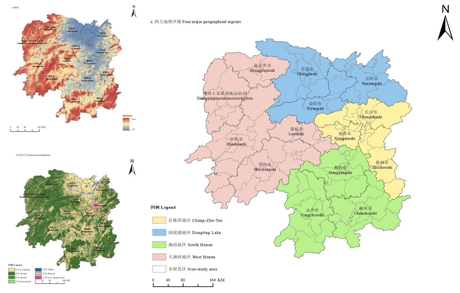
图1
研究区域 该图基于自然资源部标准地图服务网站下载的审图号为GS(2024)0650号的标准地图制作,底图无修改。下同"
表1
耕地禀赋评价指标体系"
| 维度 Dimension | 指标 Indicator | 衡量方法 Measurement method | 预测方向 Predictive direction | 权重 Weight |
|---|---|---|---|---|
| 地理条件 Geographical condition | 降水条件 Precipitation condition | 年降水量 Annual precipitation (mm) | + | 0.041 |
| 热量条件 Heat condition | ≥10 ℃积温 ≥10 ℃ accumulated temperature (℃) | + | 0.009 | |
| 植被条件 Vegetation | 归一化植被指数 Normalized difference vegetation index | + | 0.036 | |
| 区位条件 Location | 县域距上一级行政区划中心距离 The distance of the county from the center of the upper-level administrative division (km) | - | 0.028 | |
| 路网密度 Road network density | 每平方公里道路长度 The length of roads per square kilometer (km·km-2) | + | 0.259 | |
| 县域平均坡度 Average slope of the county area | 县域内所有栅格坡度的均值 The average value of all grid slope angles within the county (°) | - | 0.091 | |
| 耕地质量 Soil quality for cultivated land | 耕地坡度 Slope of cultivated land | 15°以上耕地面积/县域总耕地面积 The area of cultivated land above 15°/The total area of cultivated land in the county (%) | - | 0.009 |
| 耕地高程 Cultivated land elevation | 县域耕地平均高程 Average elevation of cultivated land in the county area (m) | - | 0.006 | |
| 地表粗糙度 Surface roughness | 单位地表曲面面积/其水平面投影面积 Unit surface area of the terrain/Area of its horizontal projection surface (%) | - | 0.011 | |
| 地表起伏度 Surface relief | 耕地相对高程差 Relative elevation difference of farmland (m) | - | 0.008 | |
| 土壤含水量 Soil water content | 土壤可用储水量 Soil available water storage capacity (mm·m-1) | + | 0.003 | |
| 土壤酸碱度Soil pH | 参照黄海潮等[ According to the research by HUANG HaiChao et al. [ | + | 0.022 | |
| 土壤肥力 Soil fertility | 土壤有机碳含量 Soil organic carbon content (%) | + | 0.039 | |
| 耕地数量 The amount of cultivated land | 人均耕地面积 Arable land per capita | 耕地面积/乡村人口数 Cultivated land area/Rural population number | + | 0.192 |
| 耕地面积占比 The proportion of cultivated land area | 耕地面积/县域总面积 Cultivated land area/Total area of the county (%) | + | 0.245 |
表2
2017—2021年湖南省及四大地理区域的耕地禀赋"
| 区域Area | 2017 | 2018 | 2019 | 2020 | 2021 |
|---|---|---|---|---|---|
| 长株潭地区Changzhutan | 0.402 | 0.403 | 0.419 | 0.430 | 0.437 |
| 洞庭湖地区Dongting Lake | 0.422 | 0.421 | 0.437 | 0.448 | 0.455 |
| 湘南地区South Hunan | 0.311 | 0.322 | 0.321 | 0.328 | 0.331 |
| 大湘西地区West Hunan | 0.224 | 0.219 | 0.223 | 0.228 | 0.225 |
| 湖南省Hunan Province | 0.320 | 0.322 | 0.328 | 0.336 | 0.339 |
表3
2017—2021年湖南省及四大地理区域的耕地禀赋基尼系数"
| 2017 | 2018 | 2019 | 2020 | 2021 | ||
|---|---|---|---|---|---|---|
| 地区内 Intra-regional | 长株潭地区Changzhutan | 0.177 | 0.176 | 0.175 | 0.175 | 0.184 |
| 洞庭湖地区Dongting Lake | 0.183 | 0.183 | 0.190 | 0.188 | 0.196 | |
| 湘南地区South Hunan | 0.229 | 0.241 | 0.235 | 0.239 | 0.253 | |
| 大湘西地区West Hunan | 0.267 | 0.278 | 0.278 | 0.270 | 0.272 | |
| 地区间 Inter-regional | 长株潭地区—洞庭湖地区Changzhutan—Dongting Lake | 0.184 | 0.185 | 0.187 | 0.186 | 0.195 |
| 长株潭地区—湘南地区Changzhutan—South Hunan | 0.221 | 0.227 | 0.225 | 0.229 | 0.242 | |
| 长株潭地区—大湘西地区Changzhutan—West Hunan | 0.285 | 0.293 | 0.296 | 0.293 | 0.301 | |
| 洞庭湖地区—湘南地区Dongting Lake—South Hunan | 0.234 | 0.240 | 0.241 | 0.245 | 0.256 | |
| 洞庭湖地区—大湘西地区Dongting Lake—West Hunan | 0.299 | 0.307 | 0.312 | 0.309 | 0.317 | |
| 湘南地区—大湘西地区South Hunan—West Hunan | 0.267 | 0.282 | 0.278 | 0.276 | 0.284 | |
| 整体基尼系数Total Gini | 0.267 | 0.275 | 0.277 | 0.277 | 0.287 | |
表4
2017—2021年湖南省按地理区域划分的耕地禀赋因子均值及变化率"
| 因子 Factor | 长株潭地区 Changzhutan | 洞庭湖地区 Dongting Lake | 湘南地区 South Hunan | 大湘西地区 West Hunan | ||||
|---|---|---|---|---|---|---|---|---|
| 均值 Average | 变化率Change rate (%) | 均值 Average | 变化率 Change rate (%) | 均值 Average | 变化率 Change rate (%) | 均值 Average | 变化率 Change rate (%) | |
| 降水条件Precipitation condition | 1429.382 | -2.3 | 1268.596 | -7.5 | 1492.085 | -1.3 | 1374.203 | -8.3 |
| 热量条件Heat condition | 6196.420 | 4.0 | 5998.556 | 3.4 | 6441.088 | 4.9 | 5866.752 | 3.1 |
| 植被条件Vegetation | 0.558 | -10.0 | 0.559 | -1.3 | 0.622 | -7.3 | 0.647 | -7.7 |
| 区位条件Location | 41.492 | 0.0 | 48.070 | 0.0 | 54.410 | 0.0 | 55.054 | 0.0 |
| 路网密度Road network density | 1.522 | 66.0 | 0.657 | 114.6 | 0.696 | 83.2 | 0.427 | 72.5 |
| 县域平均坡度 Average slope of the county area | 9.699 | 0.0 | 7.252 | 0.0 | 13.514 | 0.0 | 17.389 | 0.0 |
| 耕地坡度Slope of cultivated land | 4.561 | 25.0 | 3.477 | 31.4 | 7.014 | 38.1 | 21.762 | 14.6 |
| 耕地高程Cultivated land elevation | 162.626 | 0.2 | 86.098 | 1.1 | 240.494 | 0.3 | 241.604 | 0.6 |
| 地表粗糙度Surface roughness | 1.008 | 0.001 | 1.006 | 0.034 | 1.010 | 0.003 | 1.023 | 0.030 |
| 地表起伏度Surface relief | 36.221 | 0.7 | 27.749 | 2.9 | 47.924 | 0.1 | 71.854 | -0.1 |
| 土壤含水量Soil water content | 137.124 | 0.018 | 142.538 | 0.040 | 137.574 | -0.025 | 137.916 | 0.192 |
| 土壤酸碱度Soil pH | 5.779 | -0.1 | 6.033 | 0.0 | 5.814 | -0.1 | 5.614 | -0.1 |
| 土壤肥力Soil fertility | 1.513 | 0.1 | 1.464 | 0.3 | 1.551 | 0.4 | 1.870 | 0.2 |
| 人均耕地面积Arable land per capita | 4.773 | 33.7 | 5.068 | 39.9 | 4.019 | 14.8 | 3.094 | 0.7 |
| 耕地面积占比 The proportion of cultivated land area | 43.613 | -4.0 | 58.307 | 1.9 | 37.193 | -2.9 | 28.968 | -1.0 |
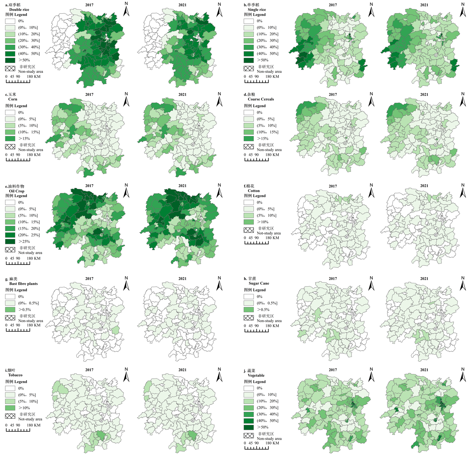
图2
2017—2021年湖南省各作物种植占比空间分布"
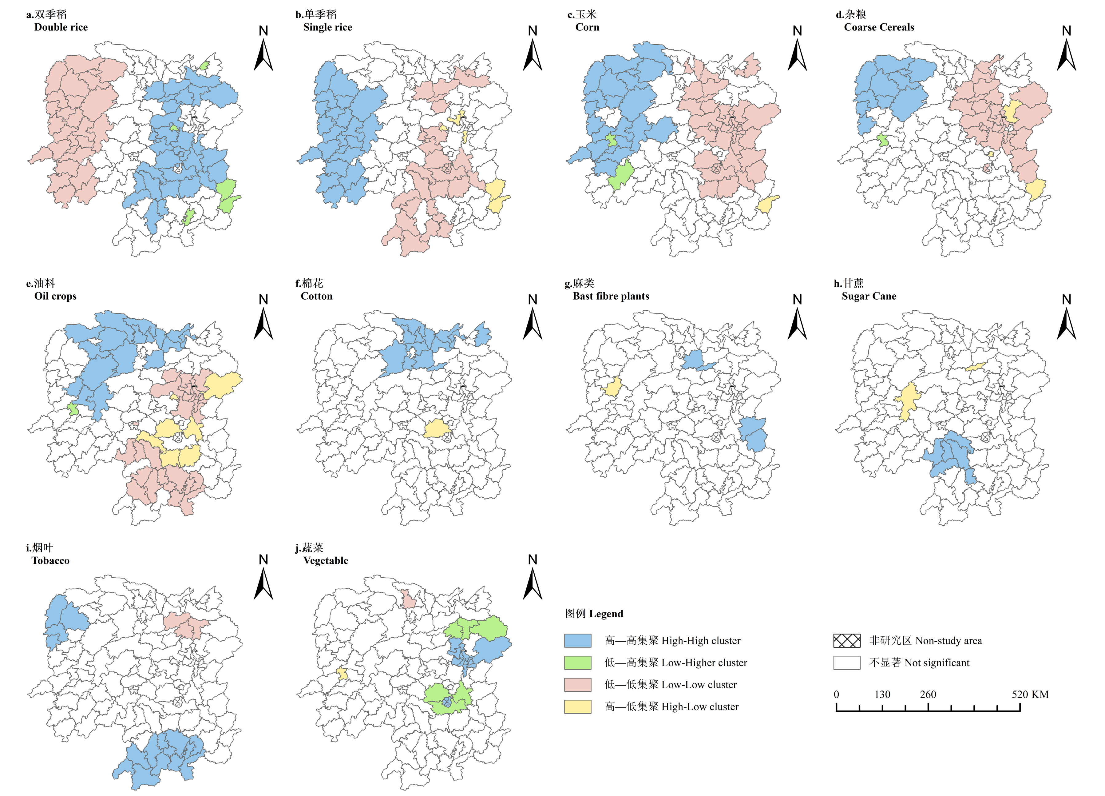
图3
2021年湖南省作物种植占比的空间集聚特征"
表5
2021年湖南省作物种植占比空间集聚特征的典型县域"
| 作物类型 Crop type | 高-高集聚 High-High cluster | 高-低集聚 High-Low cluster | 低-低集聚 Low-Low cluster | 低-高集聚 Low-High cluster |
|---|---|---|---|---|
| 双季稻 Double rice | 湘乡市、石鼓区、汉寿县、双峰县等 Xiangxiang City, Shigu District, Hanshou County, Shuangfeng County, and so on | — | 凤凰县、花垣县、龙山县等 Fenghuang County, Huayuan County, Longshan County, and so on | 韶山市、云溪区、桂东县等 Shaoshan City, Yunxi District, Guidong County, and so on |
| 单季稻 Single rice | 凤凰县、花垣县、龙山县等 Fenghuang County, Huayuan County, Longshan County, and so on | 韶山市、桂东县等 Shaoshan City, Guidong County, and so on | 湘乡市、石鼓区、汉寿县、双峰县等 Xiangxiang City, Shigu District, Hanshou County, Shuangfeng County, and so on | — |
| 玉米 Maize | 凤凰县、花垣县、龙山县等 Fenghuang County, Huayuan County, Longshan County, and so on | 桂东县 Guidong County | 湘乡市、石鼓区、汉寿县等 Xiangxiang City, Shigu District, Hanshou County, and so on | 绥宁县、鹤城区 Suining County, Hecheng District |
| 杂粮 Coarse cereals | 凤凰县、花垣县、龙山县等 Fenghuang County, Huayuan County, Longshan County, and so on | 长沙县、炎陵县、南岳区 Changsha County, Yanling County, Nanyue District | 湘乡市、石鼓区、汉寿县 Xiangxiang City, Shigu District, Hanshou County, and so on | 鹤城区 Hecheng District |
| 油料作物 Oil crops | 君山区、澧县、慈利县、沅陵县等 Junshan District, Li County, Cili County, Yuanling County, and so on | 浏阳市、衡阳县、衡东县、常宁市等 Liuyang City, Hengyang County, Hengdong County, Changning City, and so on | 岳麓区、双清区、赫山区、新田县等 Yuelu District, Shuangqing District, Heshan District, Xintian County, and so on | 鹤城区 Hecheng District |
| 棉花 Cotton | 君山区、华容县、澧县等 Junshan District, Huarong County, Li County, and so on | 衡阳县 Hengyang County | — | — |
| 麻类 Bast fiber plants | 攸县、茶陵县、汉寿县、资阳区 You County, Chaling County, Hanshou County, Ziyang District | 泸溪县 Luxi County | — | — |
| 甘蔗 Sugar cane | 祁东县、冷水滩区、东安县等 Qidong County, Lengshuitan District, Dongan County, and so on | 资阳区、溆浦县 Ziyang District, Xupu County | — | — |
| 烟叶 Tobacco | 桂阳县、新田县、花垣县、龙山县等 Guiyang County, Xintian County, Huayuan County, Longshan County, and so on | — | 湘阴县、汨罗市、沅江市 Xiangyin County, Miluo City, Yuanjiang City | — |
| 蔬菜 Vegetable | 天心区、岳麓区、雨花区、石鼓区、雁峰区等 Tianxin District, Yuelu District, Yuhua District, Shigu District, Yanfeng District, and so on | 鹤城区 Hecheng District | 临澧县 Linli County | 衡阳县、衡东县、衡南县、湘阴县、平江县、汨罗市 Hengyang County, Hengdong County, Hengnan County, Xiangyin County, Pingjiang County, Miluo City |
表6
2017—2021年湖南省种植结构类型县域数量及占比分布"
| 主导作物类型 Main crops types | 2017 | 2018 | 2019 | 2020 | 2021 | ||||||
|---|---|---|---|---|---|---|---|---|---|---|---|
| 县域数量 Number | 比例 Percentage (%) | 县域数量 Number | 比例 Percentage (%) | 县域数量 Number | 比例 Percentage (%) | 县域数量 Number | 比例 Percentage (%) | 县域数量 Number | 比例 Percentage (%) | ||
| 单作物主导 Single crop | 双季稻 Double rice | 61 | 50.4 | 51 | 42.1 | 38 | 31.4 | 37 | 30.6 | 37 | 30.6 |
| 单季稻 Single rice | 15 | 12.4 | 19 | 15.7 | 18 | 14.9 | 14 | 11.6 | 14 | 11.6 | |
| 蔬菜 Vegetable | 5 | 4.1 | 4 | 3.3 | 5 | 4.1 | 14 | 11.6 | 13 | 10.7 | |
| 油料作物 Oil crops | — | — | — | — | — | — | 1 | 0.8 | — | — | |
| 双作物主导 Dual crop | 双季稻-蔬菜 Double rice-Vegetable | 1 | 0.8 | 1 | 0.8 | — | — | 1 | 0.8 | 1 | 0.8 |
| 单季稻-蔬菜 Single rice-Vegetable | 2 | 1.7 | 1 | 0.8 | 1 | 0.8 | 2 | 1.7 | 2 | 1.7 | |
| 多作物主导 Multiple crops | 双季稻-单季稻-蔬菜 Double rice-Single rice- Vegetable | 8 | 6.6 | 15 | 12.4 | 19 | 15.7 | 16 | 13.2 | 16 | 13.2 |
| 双季稻-单季稻-油料作物 Double rice-Single rice- Oil crops | 5 | 4.1 | 7 | 5.8 | 10 | 8.3 | 9 | 7.4 | 9 | 7.4 | |
| 双季稻-单季稻-玉米 Double rice-Single rice- Maize | 1 | 0.8 | 2 | 1.7 | 2 | 1.7 | 1 | 0.8 | 1 | 0.8 | |
| 双季稻-单季稻-杂粮 Double rice-Single rice-Coarse cereals | — | — | — | — | — | — | — | — | 1 | 0.8 | |
| 双季稻-蔬菜-油料作物 Double rice-Vegetable- Oil crops | 4 | 3.3 | 3 | 2.5 | 7 | 5.8 | 6 | 5.0 | 6 | 5.0 | |
| 双季稻-蔬菜-玉米 Double rice-Vegetable- Maize | 3 | 2.5 | 3 | 2.5 | 2 | 1.7 | 3 | 2.5 | 3 | 25 | |
| 双季稻-蔬菜-烟叶 Double rice-Vegetable- Tobacco | 1 | 0.8 | 1 | 0.8 | 1 | 0.8 | — | — | — | — | |
| 单季稻-蔬菜-油料作物 Single rice-Vegetable- Oil crops | 9 | 7.4 | 8 | 6.6 | 12 | 9.9 | 13 | 10.7 | 13 | 10.7 | |
| 单季稻-蔬菜-玉米 Single rice-Vegetable- Maize | 2 | 1.7 | 2 | 1.7 | 2 | 1.7 | 1 | 0.8 | — | — | |
| 单季稻-蔬菜-杂粮 Single rice-Vegetable- Coarse cereals | 1 | 0.8 | 1 | 0.8 | 2 | 1.7 | — | — | 1 | 0.8 | |
| 单季稻-蔬菜-烟叶 Single rice-Vegetable- Tobacco | — | — | — | — | — | — | — | — | 1 | 0.8 | |
| 单季稻-油料作物-玉米 Single rice-Oil crops- Maize | 2 | 1.7 | 2 | 1.7 | 2 | 1.7 | 2 | 1.7 | 2 | 1.7 | |
| 单季稻-油料作物-杂粮 Single rice-Oil crops- Coarse cereals | 1 | 0.8 | 1 | 0.8 | — | — | 1 | 0.8 | 1 | 0.8 | |
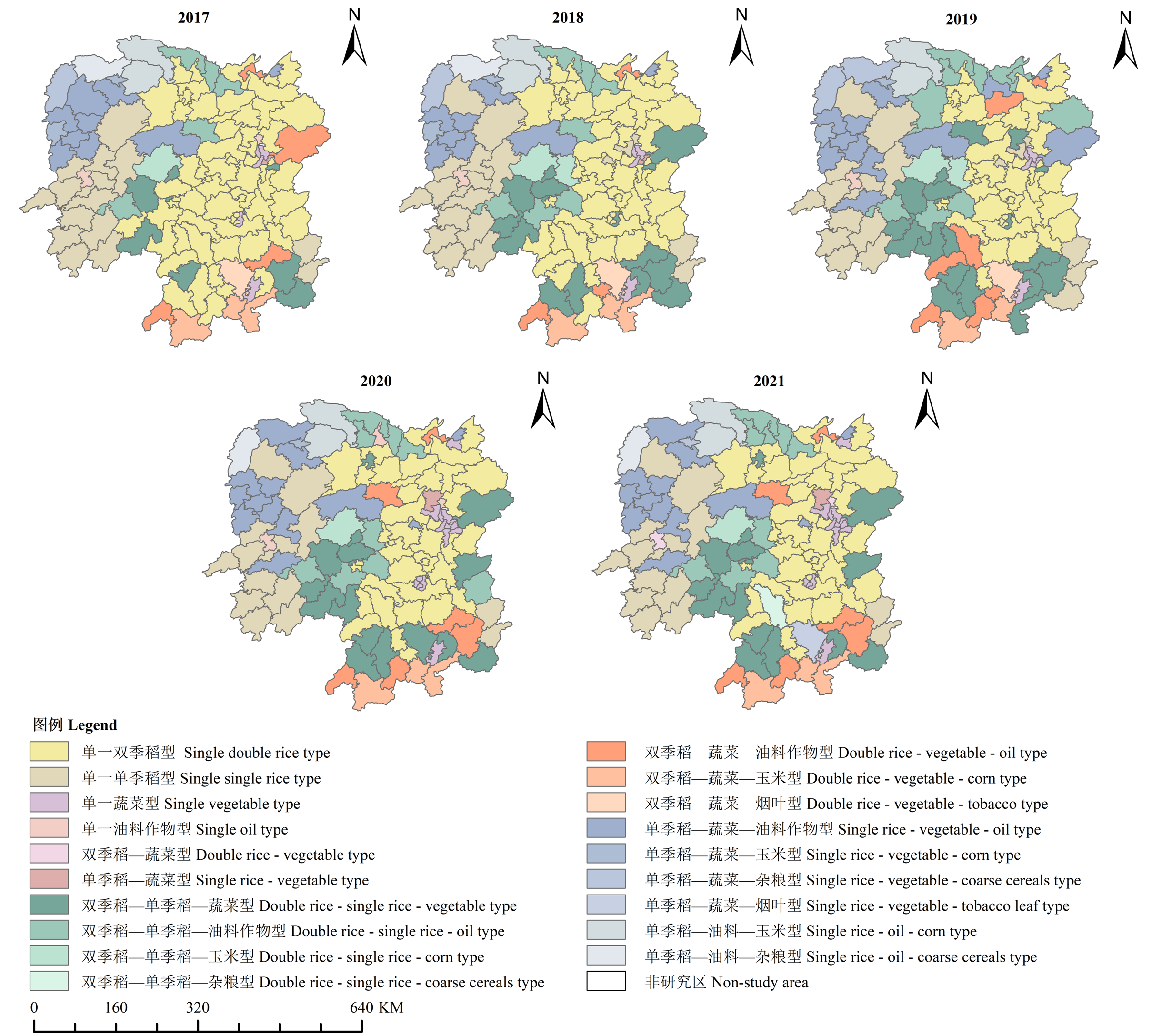
图4
2017—2021年湖南省种植结构的空间分布"
表7
2017—2021年湖南省四大地理区域主要种植结构变化趋势"
| 地理区域 Geographical regions | 主要种植结构变化趋势 Main trend of planting structure changes | 典型县域 Typical county | |||||||||||
|---|---|---|---|---|---|---|---|---|---|---|---|---|---|
| 长株潭地区 Changzhutan | 单一双季稻型(保持不变) Single double rice type (remain unchanged) | 长沙县、宁乡市、渌口区等 Changsah County, Ningxiang City, Lukou District, and so on | |||||||||||
| 单一双季稻型➯双季稻-蔬菜-其他作物型 Single double rice type ➯ Double rice-Vegetable-Other crops type | 望城区、攸县 Wangcheng District, You County | ||||||||||||
| 单一双季稻型➯单一蔬菜型 Single double rice type ➯ Single vegetable type | 岳麓区、荷塘区、天元区 Yuelu District, Hetang District, Tianyuan District | ||||||||||||
| 洞庭湖地区 Dongting Lake | 单一双季稻型(保持不变) Single double rice type (remain unchanged) | 岳阳县、湘阴县、汨罗市等 Yueyang County, Xiangyin County, Miluo County, and so on | |||||||||||
| 单一双季稻型➯双季稻-单季稻-油料作物型 Single double rice type ➯ Double rice-Single rice-Oil type | 临澧县、津市市 Linli County, Jinshi City | ||||||||||||
| 湘南地区 South Hunan | 单一双季稻型(保持不变) Single double rice type (remain unchanged) | 南岳区、耒阳市、安仁县等 Nanyue District, Leiyang City, Anren County, and so on | |||||||||||
| 单一双季稻型➯双季稻-单季稻-其他作物型 Single double rice type ➯ Double rice-Single rice-Other crops type | 苏仙区、祁阳市、道县等 Suxian District, Qiyang City, Dao County, and so on | ||||||||||||
| 大湘西地区 West Hunan | 单一单季稻型(保持不变) Single single rice type (remain unchanged) | 绥宁县、中方县、会同县等 Suining County, Zhongfang County, Huitong County, and so on | |||||||||||
| 单一单季稻型➯单季稻-蔬菜-油料作物型 Single single rice type ➯ Single rice-Vegetable-Oil type | 辰溪县、洪江市 Chenxi County, Hongjiang City | ||||||||||||
表8
2021年湖南省主要作物种植占比因子探测结果及其变化率"
| 双季稻 Double rice | 单季稻 Single rice | 玉米 Maize | 杂粮 Coarse cereals | 油料作物 Oil crops | 棉花 Cotton | 麻类 Bast fibre plants | 甘蔗 Sugar cane | 烟叶 Tobacco | 蔬菜 Vegetable | |
|---|---|---|---|---|---|---|---|---|---|---|
| 降水条件 Precipitation condition | 0.085 (-59.9) | 0.182 (27.9) | 0.151* (-42.1) | 0.079 (-69.3) | 0.301*** (10.1) | 0.657*** (8.1) | 0.108 (-4.6) | 0.044 (-25.6) | 0.240*** (-8.6) | 0.139 (-42.0) |
| 热量条件 Heat condition | 0.310*** (-0.3) | 0.354*** (12.9) | 0.349*** (28.1) | 0.375*** (39.0) | 0.145** (-11.4) | 0.096 (-47.9) | 0.0490 (-24.3) | 0.076 (-12.2) | 0.271*** (16.9) | 0.172*** (-1.5) |
| 植被条件 Vegetation conditions | 0.337*** (-21.1) | 0.217*** (-40.4) | 0.351*** (-8.2) | 0.227*** (-12.5) | 0.120 (-40.2) | 0.307*** (19.8) | 0.061 (-49.8) | 0.065 (-13.9) | 0.193** (-13.0) | 0.253*** (-3.5) |
| 区位条件 Location condition | 0.130** (2.6) | 0.164 (4.9) | 0.165** (-1.7) | 0.100* (-14.2) | 0.180** (-17.2) | 0.100 (-8.9) | 0.079 (-42.0) | 0.075 (-26.4) | 0.111 (-7.4) | 0.429*** (35.2) |
| 路网密度 Road network density | 0.288*** (7.2) | 0.171** (-35.3) | 0.288*** (-17.1) | 0.190** (-21.0) | 0.215*** (-18.5) | 0.142* (31.9) | 0.072 (-33.5) | 0.123 (-11.3) | 0.148** (-9.3) | 0.620*** (31.8) |
| 县域平均坡度 Average slope of the county area | 0.495*** (-13.9) | 0.353*** (-18.8) | 0.511*** (-3.1) | 0.410*** (-14.4) | 0.218 (-7.3) | 0.472*** (-2.0) | 0.186*** (88.9) | 0.204 (35.6) | 0.198** (-5.0) | 0.264*** (46.0) |
| 耕地坡度 Slope of cultivated land | 0.572*** (-11.5) | 0.481*** (-10.5) | 0.617*** (8.6) | 0.572*** (33.3) | 0.211* (-20.3) | 0.491*** (-10.4) | 0.164** (92.8) | 0.109 (8.7) | 0.228*** (21.9) | 0.196*** (-12.1) |
| 耕地高程 Cultivated land elevation | 0.151*** (29.4) | 0.178** (24.7) | 0.196** (5.0) | 0.164** (69.4) | 0.156** (30.8) | 0.301*** (-16.8) | 0.091 (-24.9) | 0.167*** (14.6) | 0.167** (-7.7) | 0.118 (-5.5) |
| 地表粗糙度 Surface roughness | 0.5367*** (-11.5) | 0.455*** (-13.1) | 0.575*** (-8.1) | 0.421*** (-7.1) | 0.216*** (-14.8) | 0.542*** (-4.5) | 0.120 (49.7) | 0.092 (-29.3) | 0.164** (9.9) | 0.272*** (43.6) |
| 地表起伏度 Surface relief | 0.327*** (-22.5) | 0.216*** (-10.1) | 0.682*** (0.6) | 0.448*** (-11.8) | 0.154* (-2.0) | 0.428*** (-16.8) | 0.160* (160.9) | 0.163* (27.2) | 0.178** (-21.2) | 0.201** (51.9) |
| 土壤含水量 Soil water content | 0.230*** (15.0) | 0.2551*** (23.3) | 0.168** (-2.7) | 0.232*** (3.5) | 0.209*** (-22.7) | 0.177*** (0.7) | 0.179*** (128.2) | 0.092 (-42.1) | 0.231*** (-0.2) | 0.165** (-24.9) |
| 土壤酸碱度 Soil pH | 0.342*** (4.4) | 0.271*** (5.8) | 0.305*** (5.8) | 0.163** (-8.5) | 0.181 (-1.2) | 0.428*** (-2.6) | 0.106 (23.5) | 0.135 (76.2) | 0.203*** (40.4) | 0.130 (-7.7) |
| 土壤肥力 Soil fertility | 0.520*** (-8.6) | 0.450*** (-6.2) | 0.405*** (-7.0) | 0.320*** (-5.0) | 0.092 (-10.9) | 0.136 (-15.5) | 0.120 (115.9) | 0.141* (39.2) | 0.101 (-17.9) | 0.163** (247.3) |
| 人均耕地面积 Arable land per capita | 0.163** (-38.8) | 0.207*** (-32.9) | 0.241*** (0.8) | 0.160** (-17.1) | 0.129** (33.9) | 0.309*** (42.9) | 0.075 (18.9) | 0.072 (18.7) | 0.131 (0.3) | 0.125** (-53.4) |
| 耕地面积占比 The proportion of cultivated land area | 0.446*** (-18.2) | 0.3312*** (-16.5) | 0.404*** (6.2) | 0.314*** (-9.8) | 0.227* (0.1) | 0.580*** (1.2) | 0.158** (68.4) | 0.090 (91.9) | 0.189** (-7.5) | 0.213*** (20.9) |
| [1] |
王嫚嫚, 刘颖, 蒯昊, 周晓时. 土地细碎化、耕地地力对粮食生产效率的影响: 基于江汉平原354个水稻种植户的研究. 资源科学, 2017, 39(8): 1488-1496.
doi: 10.18402/resci.2017.08.06 |
|
doi: 10.18402/resci.2017.08.06 |
|
| [2] |
唐华俊, 吴文斌, 杨鹏, 周清波, 陈仲新. 农作物空间格局遥感监测研究进展. 中国农业科学, 2010, 43(14): 2879-2888. doi: 10.3864/j.issn.0578-1752.2010.14.006.
|
|
|
|
| [3] |
雷金银, 吴霞, 王长军, 樊丽琴. 1980-2015年宁夏农作物种植结构时空变化特征分析. 干旱区资源与环境, 2017, 31(12): 172-178.
|
|
|
|
| [4] |
刘科, 黄博琛. 大食物观: 超越粮食安全战略的时代价值与实践方案. 中州学刊, 2023(5): 67-73.
|
|
|
|
| [5] |
牛海鹏, 赵同谦, 张安录, 李明秋. 基于生态位适宜度的耕地可持续利用评价. 生态学报, 2009, 29(10): 5535-5543.
|
|
|
|
| [6] |
doi: 10.1007/s12571-012-0225-9 |
| [7] |
孙晓兵, 孔祥斌, 温良友. 基于耕地要素的耕地质量评价指标体系研究及其发展趋势. 土壤通报, 2019, 50(3): 739-747.
|
|
|
|
| [8] |
doi: 10.3390/land12010237 |
| [9] |
梁书民. 中国农业种植结构及演化的空间分布和原因分析. 中国农业资源与区划, 2006, 27(2): 29-34.
|
|
|
|
| [10] |
刘珍环, 唐鹏钦, 范玲玲, 杨鹏, 吴文斌. 1980—2010年东北地区种植结构时空变化特征. 中国农业科学, 2016, 49(21): 4107-4119. doi: 10.3864/j.issn.0578-1752.2016.21.005.
|
|
|
|
| [11] |
安悦, 谭雪兰, 谭杰扬, 余航菱, 王振凯, 李文哲. 湖南省农作物种植结构演变及影响因素. 经济地理, 2021, 41(2): 156-166.
doi: 10.15957/j.cnki.jjdl.2021.02.017 |
|
doi: 10.15957/j.cnki.jjdl.2021.02.017 |
|
| [12] |
张正佳, 迟亮, 杨海成, 沈辰. 黄淮海地区农作物种植结构时空变化分析. 中国农业资源与区划, 2025, 46(4): 27-37.
|
|
|
|
| [13] |
刘航, 吴文斌, 申格, 黄清. 1996—2016年松嫩平原传统大豆种植结构的时空演变. 应用生态学报, 2018, 29(10): 3275-3282.
doi: 10.13287/j.1001-9332.201810.011 |
|
|
|
| [14] |
陶建斌, 王昀, 张馨月, 姜启樾, 吴文斌. 基于物候信息图谱的耕地种植模式遥感监测方法. 中国农业科学, 2024, 57(4): 663-678. doi: 10.3864/j.issn.0578-1752.2024.04.004.
|
|
|
|
| [15] |
张素心, 申格, 余强毅, 吴文斌. 中国耕地种植制度遥感探测及其时空特征. 中国农业科学, 2024, 57(8): 1469-1489. doi: 10.3864/j.issn.0578-1752.2024.08.005.
|
|
|
|
| [16] |
刘珍环, 杨鹏, 吴文斌, 李正国, 唐鹏钦, 李志鹏, 余强毅, 夏天, 唐华俊. 自然环境因素对农户选择种植作物的影响机制——以黑龙江省宾县为例. 中国农业科学, 2013, 46(15): 3238-3247. doi: 10.3864/j.issn.0578-1752.2013.15.019.
|
|
|
|
| [17] |
张红梅, 宋戈. 黑龙江省典型县耕地种植结构空间分异特征与影响因素. 农业机械学报, 2021, 52(5): 239-248.
|
|
|
|
| [18] |
叶初升, 马玉婷. 人力资本及其与技术进步的适配性何以影响了农业种植结构. 中国农村经济, 2020(4): 34-55.
|
|
|
|
| [19] |
钱龙, 袁航, 刘景景, 洪名勇. 农地流转影响粮食种植结构分析. 农业技术经济, 2018(8): 63-74.
|
|
|
|
| [20] |
王翌秋, 陈玉珠. 劳动力外出务工对农户种植结构的影响研究: 基于江苏和河南的调查数据. 农业经济问题, 2016, 37(2): 41-48, 111.
|
|
|
|
| [21] |
黄德林, 陈永杰. 农民工职业技能培训意愿及影响机理研究: 基于武汉市、厦门市、沧州市的实证调查. 中国软科学, 2014(3): 68-75.
|
|
|
|
| [22] |
doi: 10.3390/ijerph17041169 |
| [23] |
doi: 10.1016/j.landusepol.2021.105673 |
| [24] |
冯琳, 庞玉亭, 钟琪, 张斌斌, 陈哲祺, 王铜. 1980-2016年气候变化对湖南省农业产量的影响. 资源科学, 2019, 41(3): 582-590.
doi: 10.18402/resci.2019.03.15 |
|
|
|
| [25] |
彭文斌, 谢晓琪, 宁译萱, 苏欣怡. 数字湖南建设的空间非均衡特征及其影响因素. 经济地理, 2024, 44(6): 93-101.
doi: 10.15957/j.cnki.jjdl.2024.06.010 |
|
doi: 10.15957/j.cnki.jjdl.2024.06.010 |
|
| [26] |
doi: 10.5194/essd-13-3907-2021 |
| [27] |
陈美景, 白中科, 于潇, 王庆日, 张冰松, 曾爽. 黄河流域资源型城市国土空间转型特征与影响机制研究. 中国土地科学, 2025, 39(2): 69-81.
|
|
|
|
| [28] |
邵帅, 葛力铭, 朱佳玲. 人与自然何以和谐共生: 地理要素视角下的环境规制与环境福利绩效. 管理世界, 2024, 40(8): 119-146.
|
|
|
|
| [29] |
赵斯琦, 王晓红, 舒天竹, 唐睿. 喀斯特地区区域尺度土壤侵蚀地形因子研究. 干旱区资源与环境, 2018, 32(5): 97-103.
|
|
|
|
| [30] |
汪景宽, 张旭东, 王铁宇, 赵永存, 王秋兵. 黑土土壤质量演变初探II: 不同地区黑土中有机质、氮、硫和磷现状及变化规律. 沈阳农业大学学报, 2022, 33(4): 270-273.
|
|
|
|
| [31] |
doi: 10.25019/mdke/7.3.05 |
| [32] |
章穗, 张梅, 迟国泰. 基于熵权法的科学技术评价模型及其实证研究. 管理学报, 2010, 7(1): 34-42.
|
|
|
|
| [33] |
黄海潮, 温良友, 孔祥斌, 陈文广, 孙晓兵. 中国耕地空间格局演化对耕地适宜性的影响及政策启示. 中国土地科学, 2021, 35(2): 61-70.
|
|
|
|
| [34] |
蒋凌霄, 安悦, 谭雪兰, 米胜渊, 熊亚东, 谭杰扬. 近30年来长株潭地区农作物种植结构演变及优化对策. 经济地理, 2020, 40(1): 173-180.
doi: 10.15957/j.cnki.jjdl.2020.01.019 |
|
doi: 10.15957/j.cnki.jjdl.2020.01.019 |
|
| [35] |
|
| [36] |
王志恒, 陈安平, 方精云. 湖南省种子植物物种丰富度与地形的关系. 地理学报, 2004, 59(6): 889-894.
|
|
doi: 10.11821/xb200406011 |
|
| [37] |
赵丹丹, 刘凤, 魏晓. 湖南省农产品主产区耕地承载力评价研究. 中国农学通报, 2019, 35(27): 90-99.
doi: 10.11924/j.issn.1000-6850.casb18030151 |
|
doi: 10.11924/j.issn.1000-6850.casb18030151 |
|
| [38] |
王琛智, 张朝, 张静, 陶福禄, 陈一, 丁浒. 湖南省地形因素对水稻生产的影响. 地理学报, 2018, 73(9): 1792-1808.
doi: 10.11821/dlxb201809014 |
|
doi: 10.11821/dlxb201809014 |
|
| [39] |
李佳玲, 侯兰金, 朱吉贝, 刘庆. 近20年湖南省耕地开发强度时空分异研究. 中国农业资源与区划, 2021, 42(11): 199-207.
|
|
|
|
| [40] |
米胜渊, 谭雪兰, 谭杰扬, 蒋凌霄, 王振凯. 近30年来洞庭湖地区水稻种植面积演变的影响因素分析. 自然资源学报, 2020, 35(10): 2499-2510.
doi: 10.31497/zrzyxb.20201015 |
|
doi: 10.31497/zrzyxb.20201015 |
|
| [41] |
姚增福, 刘欣. 现代农业全要素生产率分解及空间优化差异: 来自湘南农户案例及VRS-DEA模型的实证检验. 经济地理, 2016, 36(12): 119-125.
|
|
|
|
| [42] |
王娟. 工业化背景下农业欠发达地区的跨越式发展——基于对农牧交错地带农业转型的考察. 中国社会科学, 2025(3): 22-41, 204-205.
|
|
|
| [1] | 郭建国, 姜小凤, 谢晓丽, 郑荣, 缪纯庆, 魏建荣. 河西走廊作物种植结构对棉铃虫成虫寄主类型形成的影响[J]. 中国农业科学, 2025, 58(14): 2782-2792. |
| [2] | 王楚凡, 牛俊. 西北地区主要粮食作物种植的水、碳足迹及布局优化[J]. 中国农业科学, 2024, 57(6): 1137-1152. |
| [3] | 周江,向平安. 湖南不同季别稻作系统的生态能值分析[J]. 中国农业科学, 2018, 51(23): 4496-4514. |
| [4] | 郭尔静,杨晓光,王晓煜,张天一,黄晚华,刘子琪,Tao Li. 湖南省双季稻产量差时空分布特征[J]. 中国农业科学, 2017, 50(2): 399-412. |
| [5] | 宋伟,胡婉君,徐宗季,刘兵,樊艳,倪阳,杨慧萍. 湖南省主要早籼稻品种挥发性物质种类及含量[J]. 中国农业科学, 2017, 50(2): 348-361. |
| [6] | 刘珍环,唐鹏钦,范玲玲,杨 鹏,吴文斌. 1980—2010年东北地区种植结构时空变化特征[J]. 中国农业科学, 2016, 49(21): 4107-4119. |
| [7] | 胡琼,吴文斌,宋茜,余强毅,杨鹏,唐华俊. 农作物种植结构遥感提取研究进展[J]. 中国农业科学, 2015, 48(10): 1900-1914. |
|
||
