| [1] |
ZHANG M, WU B F, ZENG H W, HE G J, LIU C, TAO S Q, ZHANG Q, NABIL M, TIAN F Y, BOFANA J, et al. GCI30: A global dataset of 30 m cropping intensity using multisource remote sensing imagery. Earth System Science Data, 2021, 13(10): 4799-4817.
|
| [2] |
LIU C, ZHANG Q, TAO S Q, QI J G, DING M J, GUAN Q H, WU B F, ZHANG M, NABIL M, TIAN F Y, et al. A new framework to map fine resolution cropping intensity across the globe: Algorithm, validation, and implication. Remote Sensing of Environment, 2020, 251: 112095.
|
| [3] |
WU W B, YU Q Y, YOU L Z, CHEN K, TANG H J, LIU J G. Global cropping intensity gaps: Increasing food production without cropland expansion. Land Use Policy, 2018, 76: 515-525.
|
| [4] |
NOVELLI L E, CAVIGLIA O P, PIÑEIRO G. Increased cropping intensity improves crop residue inputs to the soil and aggregate- associated soil organic carbon stocks. Soil and Tillage Research, 2017, 165: 128-136.
|
| [5] |
CHALLINOR A J, PARKES B, RAMIREZ-VILLEGAS J. Crop yield response to climate change varies with cropping intensity. Global Change Biology, 2015, 21(4): 1679-1688.
|
| [6] |
|
|
ZHANG S X, SHEN G, YU Q Y, WU W B. Remote sensing detection of cropping system and its spatial-temporal pattern in China. Scientia Agricultura Sinica, 2024, 57(8): 1469-1489. doi: 10.3864/j.issn.0578-1752.2024.08.005. (in Chinese)
|
| [7] |
YU Q Y, VAN VLIET J, VERBURG P H, YOU L Z, YANG P, WU W B. Harvested area gaps in China between 1981 and 2010: Effects of climatic and land management factors. Environmental Research Letters, 2018, 13(4): 044006.
|
| [8] |
LIU L, XIAO X M, QIN Y W, WANG J, XU X L, HU Y M, QIAO Z. Mapping cropping intensity in China using time series Landsat and Sentinel-2 images and Google Earth Engine. Remote Sensing of Environment, 2020, 239: 111624.
|
| [9] |
YAN H M, LIU F, QIN Y W, NIU Z E, DOUGHTY R, XIAO X M. Tracking the spatio-temporal change of cropping intensity in China during 2000-2015. Environmental Research Letters, 2019, 14(3): 035008.
|
| [10] |
KONTGIS C, SCHNEIDER A, OZDOGAN M. Mapping rice paddy extent and intensification in the Vietnamese Mekong River Delta with dense time stacks of Landsat data. Remote Sensing of Environment, 2015, 169: 255-269.
|
| [11] |
LIU X X, ZHENG J P, YU L, HAO P Y, CHEN B, XIN Q C, FU H H, GONG P. Annual dynamic dataset of global cropping intensity from 2001 to 2019. Scientific Data, 2021, 8: 283.
|
| [12] |
QIU B W, LU D F, TANG Z H, SONG D J, ZENG Y H, WANG Z Z, CHEN C C, CHEN N, HUANG H Y, XU W M. Mapping cropping intensity trends in China during 1982-2013. Applied Geography, 2017, 79: 212-222.
|
| [13] |
GRAY J, FRIEDL M, FROLKING S, RAMANKUTTY N, NELSON A, GUMMA M K. Mapping Asian cropping intensity with MODIS. IEEE Journal of Selected Topics in Applied Earth Observations and Remote Sensing, 2014, 7(8): 3373-3379.
|
| [14] |
OLIPHANT A J, THENKABAIL P S, TELUGUNTLA P, XIONG J, GUMMA M K, CONGALTON R G, YADAV K. Mapping cropland extent of Southeast and Northeast Asia using multi-year time-series Landsat 30-m data using a random forest classifier on the Google Earth Engine Cloud. International Journal of Applied Earth Observation and Geoinformation, 2019, 81: 110-124.
|
| [15] |
JAIN M, MONDAL P, DEFRIES R S, SMALL C, GALFORD G L. Mapping cropping intensity of smallholder farms: A comparison of methods using multiple sensors. Remote Sensing of Environment, 2013, 134: 210-223.
|
| [16] |
GUO Y, XIA H M, PAN L, ZHAO X Y, LI R M, BIAN X Q, WANG R M, YU C. Development of a new phenology algorithm for fine mapping of cropping intensity in complex planting areas using sentinel-2 and google earth engine. ISPRS International Journal of Geo-Information, 2021, 10(9): 587.
|
| [17] |
PAN L, XIA H M, YANG J, NIU W H, WANG R M, SONG H Q, GUO Y, QIN Y C. Mapping cropping intensity in Huaihe basin using phenology algorithm, all Sentinel-2 and Landsat images in Google Earth Engine. International Journal of Applied Earth Observation and Geoinformation, 2021, 102: 102376.
|
| [18] |
GAO F, MASEK J, SCHWALLER M, HALL F. On the blending of the Landsat and MODIS surface reflectance: predicting daily Landsat surface reflectance. IEEE Transactions on Geoscience and Remote Sensing, 2006, 44(8): 2207-2218.
|
| [19] |
ZHU X L, CHEN J, GAO F, CHEN X H, MASEK J G. An enhanced spatial and temporal adaptive reflectance fusion model for complex heterogeneous regions. Remote Sensing of Environment, 2010, 114(11): 2610-2623.
|
| [20] |
LIU X, DENG C W, CHANUSSOT J, HONG D F, ZHAO B J. StfNet: A two-stream convolutional neural network for spatiotemporal image fusion. IEEE Transactions on Geoscience and Remote Sensing, 2019, 57(9): 6552-6564.
|
| [21] |
GAO F, ANDERSON M C, ZHANG X Y, YANG Z W, ALFIERI J G, KUSTAS W P, MUELLER R, JOHNSON D M, PRUEGER J H. Toward mapping crop progress at field scales through fusion of Landsat and MODIS imagery. Remote Sensing of Environment, 2017, 188: 9-25.
|
| [22] |
LI L, ZHAO Y L, FU Y C, PAN Y Z, YU L, XIN Q C. High resolution mapping of cropping cycles by fusion of landsat and MODIS data. Remote Sensing, 2017, 9(12): 1232.
|
| [23] |
SON N T, CHEN C F, CHANG L Y, CHEN C R, SOBUE S I, MINH V Q, CHIANG S H, NGUYEN L D, LIN Y W. A logistic-based method for rice monitoring from multitemporal MODIS-Landsat fusion data. European Journal of Remote Sensing, 2016, 49(1): 39-56.
|
| [24] |
牛海鹏, 王占奇, 肖东洋. 基于时空数据融合的县域水稻种植面积提取. 农业机械学报, 2020, 51(4): 156-163.
|
|
NIU H P, WANG Z Q, XIAO D Y. Paddy rice planting area extraction in county-level based on spatiotemporal data fusion. Transactions of the Chinese Society for Agricultural Machinery, 2020, 51(4): 156-163. (in Chinese)
|
| [25] |
WANG J S, HE P, LIU Z C, JING Y D, BI R T. Yield estimation of summer maize based on multi-source remote-sensing data. Agronomy Journal, 2022, 114(6): 3389-3406.
|
| [26] |
CAO R Y, XU Z C, CHEN Y, CHEN J, SHEN M G. Reconstructing high-spatiotemporal-resolution (30 m and 8-days) NDVI time-series data for the Qinghai-Tibetan Plateau from 2000-2020. Remote Sensing, 2022, 14(15): 3648.
|
| [27] |
ZHU X L, ZHAN W F, ZHOU J X, CHEN X H, LIANG Z C, XU S, CHEN J. A novel framework to assess all-round performances of spatiotemporal fusion models. Remote Sensing of Environment, 2022, 274: 113002.
|
| [28] |
雷晨阳, 孟祥超, 邵枫. 遥感影像时—空融合的“点”-“线”-“面”质量评价. 遥感学报, 2021, 25(3): 791-802.
|
|
LEI C Y, MENG X C, SHAO F. Spatio-temporal fusion quality evaluation based on “Point”-“Line”-“Plane” aspects. National Remote Sensing Bulletin, 2021, 25(3): 791-802. (in Chinese)
|
| [29] |
LI X D, FOODY G M, BOYD D S, GE Y, ZHANG Y H, DU Y, LING F. SFSDAF: An enhanced FSDAF that incorporates sub-pixel class fraction change information for spatio-temporal image fusion. Remote Sensing of Environment, 2020, 237: 111537.
|
| [30] |
QIU B W, HU X, CHEN C C, TANG Z H, YANG P, ZHU X L, YAN C, JIAN Z Y. Maps of cropping patterns in China during 2015-2021. Scientific Data, 2022, 9: 479.
|
| [31] |
HAN J C, ZHANG Z, LUO Y C, CAO J, ZHANG L L, ZHUANG H M, CHENG F, ZHANG J, TAO F L. Annual paddy rice planting area and cropping intensity datasets and their dynamics in the Asian monsoon region from 2000 to 2020. Agricultural Systems, 2022, 200: 103437.
|
| [32] |
徐新良, 刘纪远, 张树文, 李仁东, 颜长珍, 吴世新. 中国多时期土地利用土地覆被遥感监测数据集 (CNLUCC). 资源环境科学数据注册与出版系统, 2018.
|
|
XU X L, LIU J Y, ZHANG S W, LI R D, YAN C Z, WU S X. China multi-period land use remote sensing monitoring data set. Resource and Environmental Science Data Platform, 2018. (in Chinese)
|
| [33] |
NING J, LIU J Y, KUANG W H, XU X L, ZHANG S W, YAN C Z, LI R D, WU S X, HU Y F, DU G M, CHI W F, PAN T, NING J. Spatiotemporal patterns and characteristics of land-use change in China during 2010-2015. Journal of Geographical Sciences, 2018, 28(5): 547-562.
|
| [34] |
刘纪远, 宁佳, 匡文慧, 徐新良, 张树文, 颜长珍, 李仁东, 吴世新, 胡云锋, 杜国明, 迟文峰, 潘涛, 宁静. 2010—2015年中国土地利用变化的时空格局与新特征. 地理学报, 2018, 73(5): 789-802.
|
|
LIU J Y, NING J, KUANG W H, XU X L, ZHANG S W, YAN C Z, LI R D, WU S X, HU Y F, DU G M, CHI W F, PAN T, NING J. Spatio-temporal patterns and characteristics of land-use change in China during 2010-2015. Acta Geographica Sinica, 2018, 73(5): 789-802. (in Chinese)
|
| [35] |
CHENG Q, LIU H Q, SHEN H F, WU P H, ZHANG L P. A spatial and temporal nonlocal filter-based data fusion method. IEEE Transactions on Geoscience and Remote Sensing, 2017, 55(8): 4476-4488.
|
| [36] |
CHEN Y, CAO R Y, CHEN J, LIU L C, MATSUSHITA B. A practical approach to reconstruct high-quality Landsat NDVI time-series data by gap filling and the Savitzky-Golay filter. ISPRS Journal of Photogrammetry and Remote Sensing, 2021, 180: 174-190.
|
| [37] |
SAKAMOTO T. Refined shape model fitting methods for detecting various types of phenological information on major U.S. crops. ISPRS Journal of Photogrammetry and Remote Sensing, 2018, 138: 176-192.
|
| [38] |
STEVEN M D, MALTHUS T J, BARET F, XU H, CHOPPING M J. Intercalibration of vegetation indices from different sensor systems. Remote Sensing of Environment, 2003, 88(4): 412-422.
|
| [39] |
BECK P S A, ATZBERGER C, HØGDA K A, JOHANSEN B, SKIDMORE A K. Improved monitoring of vegetation dynamics at very high latitudes: A new method using MODIS NDVI. Remote Sensing of Environment, 2006, 100(3): 321-334.
|
| [40] |
ESTEL S, KUEMMERLE T, ALCÁNTARA C, LEVERS C, PRISHCHEPOV A, HOSTERT P. Mapping farmland abandonment and recultivation across Europe using MODIS NDVI time series. Remote Sensing of Environment, 2015, 163: 312-325.
|
| [41] |
XIANG M T, YU Q Y, WU W B. From multiple cropping index to multiple cropping frequency: Observing cropland use intensity at a finer scale. Ecological Indicators, 2019, 101: 892-903.
|
| [42] |
ZHU X L, CAI F Y, TIAN J Q, WILLIAMS T K. Spatiotemporal fusion of multisource remote sensing data: literature survey, taxonomy, principles, applications, and future directions. Remote Sensing, 2018, 10(4): 527.
|
| [43] |
ZHOU J X, CHEN J, CHEN X H, ZHU X L, QIU Y A, SONG H H, RAO Y H, ZHANG C S, CAO X, CUI X H. Sensitivity of six typical spatiotemporal fusion methods to different influential factors: A comparative study for a normalized difference vegetation index time series reconstruction. Remote Sensing of Environment, 2021, 252: 112130.
|
| [44] |
BELGIU M, STEIN A. Spatiotemporal image fusion in remote sensing. Remote Sensing, 2019, 11(7): 818.
|
| [45] |
MENG X C, LIU Q, SHAO F, LI S T. Spatio-temporal-spectral collaborative learning for spatio-temporal fusion with land cover changes. IEEE Transactions on Geoscience and Remote Sensing, 2022, 60: 5704116.
|
| [46] |
JIANG M H, SHEN H F, LI J. Deep-learning-based spatio-temporal- spectral integrated fusion of heterogeneous remote sensing images. IEEE Transactions on Geoscience and Remote Sensing, 2022, 60: 5410915.
|
| [47] |
韦锋, 徐源琴. 农业税减免与农业全要素生产率: 来自中国全面取消农业税的证据. 世界农业, 2020(12): 87-97.
|
|
WEI F, XU Y Q. Agricultural tax relief and total factor productivity in agriculture: Evidence from China’s total abolition of agricultural Taxes. World Agriculture, 2020(12): 87-97. (in Chinese)
|
| [48] |
黄季焜, 王晓兵, 智华勇, 黄珠容, Scott Rozelle. 粮食直补和农资综合补贴对农业生产的影响. 农业技术经济, 2011(1): 4-12.
|
|
HUANG J K, WANG X B, ZHI H Y, HUANG Z R, ROZELLE S. Influence of direct grain subsidy and comprehensive agricultural subsidies on agricultural production. Journal of Agrotechnical Economics, 2011(1): 4-12. (in Chinese)
|
| [49] |
曹凑贵, 江洋, 汪金平, 袁鹏丽, 陈松文. 稻虾共作模式的“双刃性”及可持续发展策略. 中国生态农业学报, 2017, 25(9): 1245-1253.
|
|
CAO C G, JIANG Y, WANG J P, YUAN P L, CHEN S W. “Dual character” of rice-crayfish culture and strategies for its sustainable development. Chinese Journal of Eco-Agriculture, 2017, 25(9): 1245-1253. (in Chinese)
|


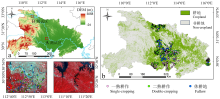
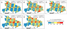
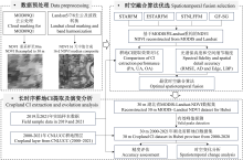
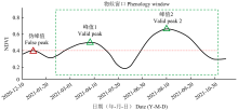
 ), 马海荣1, 罗治情1, 陈娉婷1, 郑明雪1, 官波1, 徐保东2, 宋茜3(