


中国农业科学 ›› 2025, Vol. 58 ›› Issue (6): 1159-1172.doi: 10.3864/j.issn.0578-1752.2025.06.009
宋岩1,2( ), 柴明堂1,2(), 李王成1, 孙利英1, 吾连恩·赛尔奴1, 杜天择1
收稿日期:2024-05-07
接受日期:2024-06-11
出版日期:2025-03-25
发布日期:2025-03-25
通信作者:
联系方式:
宋岩,E-mail:1048182130@qq.com。
基金资助:
SONG Yan1,2(), CHAI MingTang1,2(), LI WangCheng1, SUN LiYing1, Wulianen Saiernu1, DU TianZe1
Received:2024-05-07
Accepted:2024-06-11
Published:2025-03-25
Online:2025-03-25
摘要:
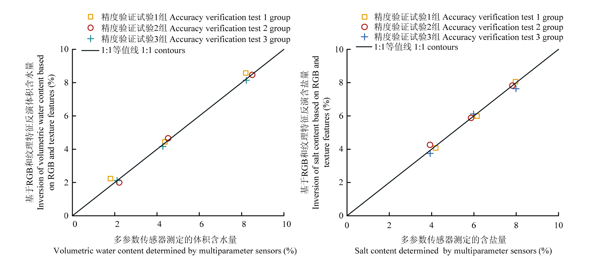
【目的】 盐渍土是全球性的生态环境问题。快速精准的监测表层土壤水分、盐分信息为土壤盐渍化的治理和改良提供支持。【方法】 本研究在小尺度上,将高精度光学遥感和图像数字处理技术相结合,提出一种基于土壤表观色彩参数(RGB)和纹理特征值预测土壤含水量、含盐量的定量估算方法。首先利用介电常数和含水量、电导率和含盐量之间的关系标定了土壤多参数传感器。其次利用图像数字处理技术,提取土壤的3种色彩参数(RGB)和纹理特征,并通过相关性分析等方法分别确定相关性最大的变量,并构建RGB、纹理特征同土壤含水量、含盐量的最优拟合模型。最后利用传感器法验证反演方法的精准度。【结果】 土壤含水量与RGB拟合的三元回归模型拟合效果最好,R 2为0.97。土壤含盐量与RGB和纹理特征的拟合中,当含盐量≥6%时,含盐量与土壤的表观白色占比拟合的一元多项式模型拟合效果最好,R 2为0.97;当含盐量<6%时,含盐量与纹理特征值中的自相关拟合效果最好,R 2为0.93。经过对比计算标定后的多参数传感器法和本文提出的反演方法得到的土壤含水量和含盐量,发现两种方法测量的土壤含水量相对误差范围为0.27%—9.48%,土壤含盐量相对误差范围为0.07%—8.64%,且绝对误差均<1%。【结论】 本研究为土壤表观水盐信息的反演提供了一种方案,为土壤表层的水盐的快速、准确的测定提供了理论依据和技术支撑。
宋岩, 柴明堂, 李王成, 孙利英, 吾连恩·赛尔奴, 杜天择. 基于RGB和纹理特征的土壤表层水盐信息反演方法[J]. 中国农业科学, 2025, 58(6): 1159-1172.
SONG Yan, CHAI MingTang, LI WangCheng, SUN LiYing, Wulianen Saiernu, DU TianZe. A Method for Estimating Water-Salinity Information of Soil Surface Using RGB and Texture Features[J]. Scientia Agricultura Sinica, 2025, 58(6): 1159-1172.
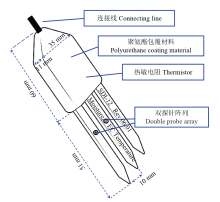
图1
土壤多参数传感器示意图"
表1
土壤多参数传感器性能数据"
| 参数 Parameter | 测量范围 Measurement range | 分辨率 Resolution ratio | 测量精度 Measurement accuracy |
|---|---|---|---|
| 介电常数 Dielectric constant | 0.88—81.88 | 0.1 | 1 |
| 电导率 Electrical conductivity | 0—20 dS·m-1 | 0.01 dS·m-1 | ±5% |
| 温度 Temperature | -40.00—80.00 ℃ | 0.1 ℃ | ±0.5 ℃ |
图2
土壤多参数传感器校准试验过程"

表2
不同含水量与含盐量下土壤表观色彩参数(RGB)及纹理特征的提取试验设计"
| 测定项目 Item | 质量含水量Moisture content (%) | 含盐量Salt content (%) |
|---|---|---|
| 土壤含水量 T1 | 0、2、4、6、8、10、12、14、16、18 | 0、2 |
| 土壤含盐量 T2 | 4、6 | 0、2、4、6、8、10、12、14、16、18 |
表3
本文使用到的纹理特征"
| 纹理特征 Texture feature | 名称 Name | 描述 Description | 公式 Formula |
|---|---|---|---|
| MEA | 均值 Mean | 纹理的平均情况 Average situation of texture | $M E A=\sum_{i=0}^{N-1} \sum_{j=0}^{N-1} i \times p(i, j)$ |
| STD | 标准差 Standard deviation | 图像中像素值的变化程度 The degree of change of pixel value in the image | $S T D=\sqrt{\sum_{i} \sum_{j} p(i, j) \times(i-M E A)^{2}}$ |
| VAR | 方差 Variance | 纹理变化的大小 The size of texture change | $V A R=\sum_{i} \sum_{j}(i-M E A)^{2} p(i, j)$ |
| CON | 对比度 Contrast | 纹理的清晰度 The clarity of texture | $C O N=\sum_{n=0}^{N g-1} n^{2}\left\{\begin{array}{c} \sum_{i=1}^{N g} \sum_{j=1}^{N g} p(i, j) \\ |i-j|=n \end{array}\right\}$ |
| DIS | 非相似性 Dissimilarity | 图像中灰度级对之间的差异性 The difference between gray level pairs in the image | $D I S=\sum_{i} \sum_{j} p(i, j) \times|i-j|$ |
| HOM | 均一性 Homogeneity | 局部纹理同质性 Local texture homogeneity | $H O M=\sum_{i} \sum_{j} \frac{1}{1+|i-j|} p(i, j)$ |
| ASM | 角二阶矩 Angle two matrix | 图像中纹理的均匀性和清晰度 The uniformity and clarity of the texture in the image | $A S M=\sum_{i} \sum_{j}\{p(i, j)\}^{2}$ |
| ENR | 能量 Energy | 图像灰度分布均匀程度和纹理粗细度 Image gray distribution uniformity and texture thickness | $E N R=\sum_{i} \sum_{j}\{p(i, j)\}^{2}$ |
| MAX | 最大值 Maximum value | 图像中最明显或最突出的纹理元素的强度或尺度 The intensity or scale of the most obvious or prominent texture element in the image | $M A X=\max \{p(i, j)\}$ |
| ENT | 熵 Entropy | 图像中纹理的非均匀程度或复杂程度 The non-uniformity or complexity of the texture in the image | $E N T=-\sum_{i} \sum_{j} p(i, j) \log (p(i, j))$ |
| COR | 相关性 Correlation | 纹理的一致性 Texture consistency | $C O R=\frac{\sum_{i} \sum_{j}(i, j) p(i, j)-\mu_{x} \mu_{y}}{\sigma_{x} \sigma_{y}}$ |
| IDM | 逆差矩 Inverse difference moment | 图像纹理的同质性,度量图像纹理局部变化的多少 The homogeneity of image texture measures the local change of image texture | $I D M=\sum_{i} \sum_{j} \frac{1}{1+(i-j)^{2}} p(i, j)$ |
| AUT | 自相关 Autocorrelation | 纹理的粗细度及方向性等特征参数 Feature parameters such as texture thickness and directionality | $A U T=\sum_{i} \sum_{j} i \times j \times p(i, j)$ |
表4
不同含水量与含盐量下水盐信息反演精度验证试验设计"
| 编号 Numbering | 含水量 Water content (%) | 含盐量 Salt content (%) |
|---|---|---|
| 1 | 2 | 4、6、8 |
| 2 | 4 | |
| 3 | 6 | |
| 4 | 8 |
图3
不同传感器的土壤体积含水量与介电常数的关系"
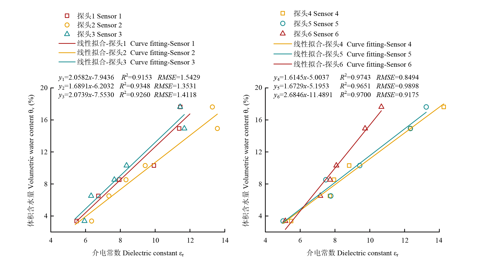
表5
不同传感器电导率与土壤含盐量标定参数"
| 探头序号 Probe serial number | 参数a Parameter a | 决定系数 Coefficient of determination (R2) |
|---|---|---|
| 1 | 4.3305 | 0.90 |
| 2 | 0.6691 | |
| 3 | 4.0943 | |
| 4 | 0.8464 | |
| 5 | -6.5299 | |
| 6 | -14.9267 |
图4
不同传感器的土壤含盐量与电导率的关系"
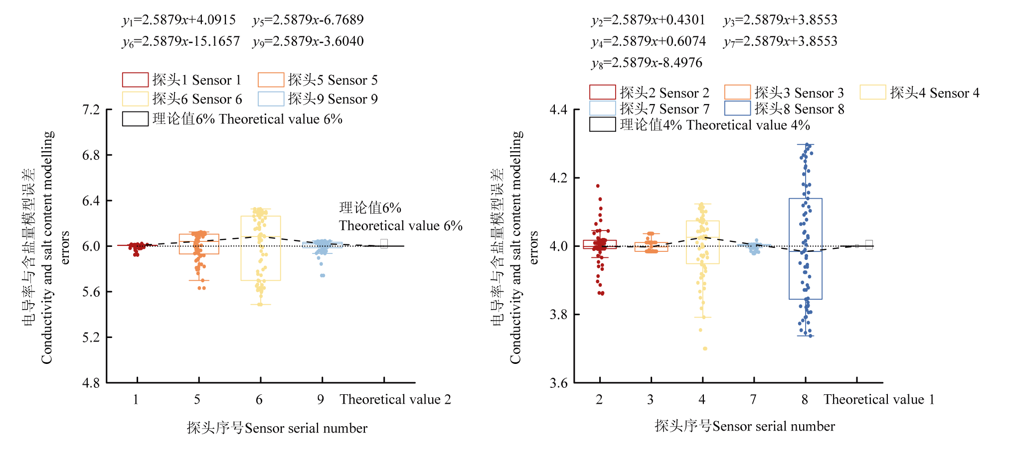
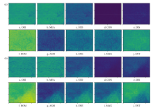
图5
土壤含水量0、含盐量0(a)和含水量4%、含盐量6%(b)的部分纹理特征"


图6
土壤含水量(a)、含盐量(b)与纹理特征的相关性"
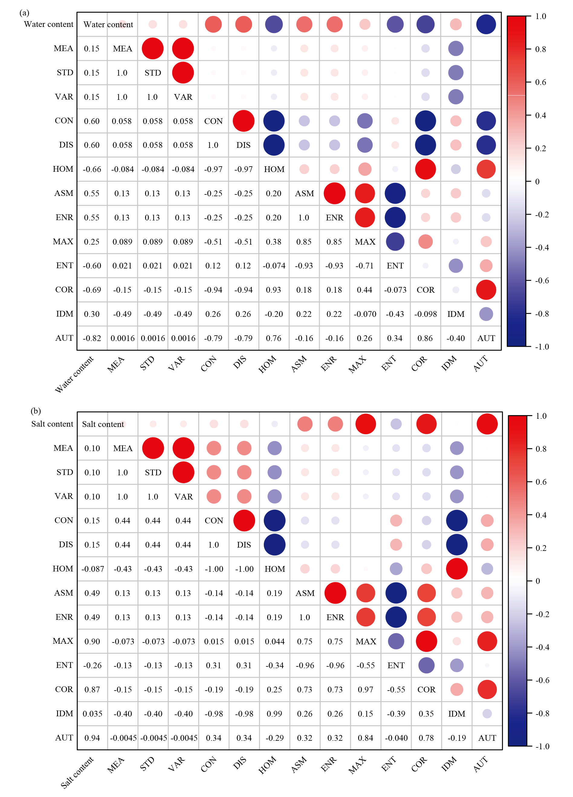
表6
RGB特征值与土壤含水量的皮尔逊相关分析"
| 样本数 Number of samples | 参数 Parameter | R2 | Sig. |
|---|---|---|---|
| 10 | R | -0.93 | <0.01 |
| G | -0.94 | ||
| B | -0.91 |
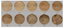
图7
不同含水量土样试样筒表观摄影图像"

表7
土壤含水量与表观色彩参数(R、G、B)的主成分分析各项评估指标"
| 名称Name | 意义Meaning | 结果Result |
|---|---|---|
| KMO检验 KMO test | 测量变量之间的共同度,即共享的统计变异量 The commonality between the measured variables, that is, the shared statistical variation | KMO=0.82,适合进行因子分析 KMO=0.82, which is suitable for factor analysis |
| 巴特利特检验 Bartlett test | 评估变量之间的相关性是否足够支持进行主成分分析 To assess whether the correlation between variables is sufficient to support principal component analysis | Sig.值(显著性概率)小于0.001 The Sig. value (probability of significance) is less than 0.001 |
| 总方差解释 Total variance explanation | 衡量各主成分对原始数据信息的解释的重要指标 An important indicator to measure the interpretation of the original data information by each principal component | R、G、B三者的总方差解释为99.71% The total variance of R, G and B is 99.71% |
| Durbin-Waston检验 Durbin-Waston test | 检验回归分析中残差的一阶自相关 Test the first-order autocorrelation of residuals in regression analysis | Durbin-Waston=2.13, 不存在自相关性 Durbin-Waston=2.13,no autocorrelation exists |
表8
基于RGB与纹理特征反演土壤含水量的相关模型"
| 自变量 Independent variable | 线性回归方程 Equation of linear regression | 模型检验 Model calibration | |
|---|---|---|---|
| R2 | RMSE | ||
| AUT | y=6817.6×AUT2-204398×AUT+5×10⁶ | 0.89 | 3.1801×10¹¹ |
| R | y=-0.2599×R+48.1690 | 0.96 | 1.17 |
| G | y=-0.2620×G+39.3632 | 0.95 | 1.21 |
| B | y=-0.2690×B+32.2558 | 0.96 | 1.16 |
| R、G、B | y=-0.097×R-0.052×G-0.118×B+39.874 | 0.97 | 0.85 |
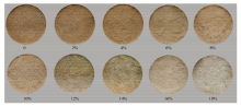
图8
不同含盐量土样试样筒表观摄影图像"
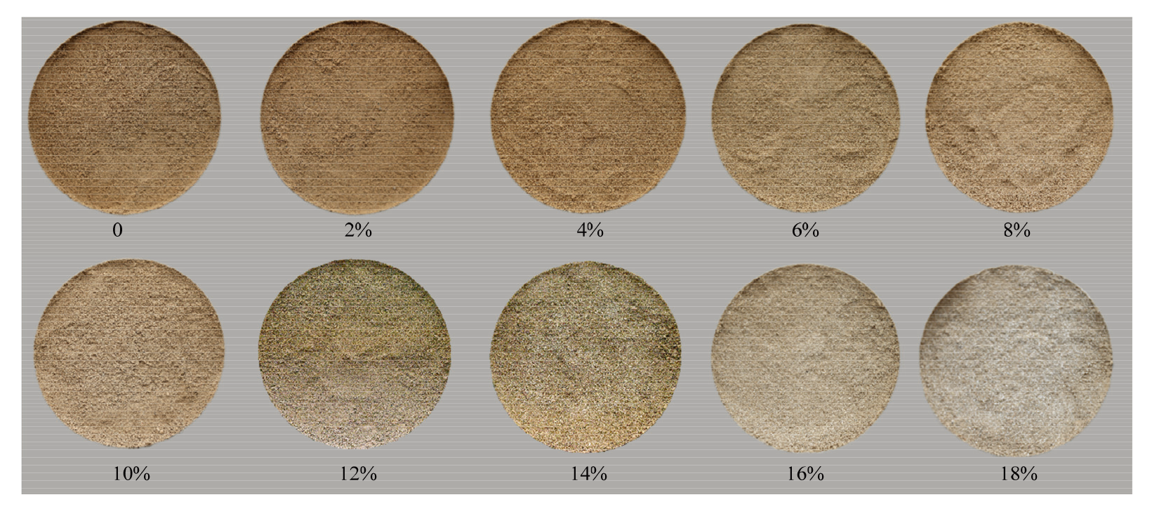
表9
基于RGB与纹理特征反演含盐量的相关模型"
| 含盐量 Salt content | 自变量 Independent variable x | 模型方程 Model equation | R2 | RMSE |
|---|---|---|---|---|
| ≥6% | 含盐量白色占比 Salt content of white proportion | y=2.8720x+2.7696 | 0.91 | 1.62 |
| y=3.2606lnx+8.6280 | 0.88 | 5.96 | ||
| y=-0.3396x2+4.7752x+1.3118 | 0.97 | 0.85 | ||
| <6% | 纹理特征 Texture features | y=1.919×10⁻¹⁷AUT3-2.522×10⁻¹⁰AUT2+0.001AUT-1602.839 | 0.93 | 9.18 |
| y=-42720.899MAX3+28956.138MAX2-623.716MAX+5.737 | 0.71 | 39.13 | ||
| y=6.35×10¹³COR3-1.27×10¹⁴COR2+6.351×10¹³COR+81.921 | 0.77 | 38.26 |
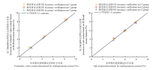
图9
基于RGB和纹理特征反演的土壤体积含水量、含盐量与多参数传感器测定值的比较"
| [1] |
|
| [2] |
|
| [3] |
|
| [4] |
王忠静, 于蘇越, 许兴. 基于文献计量学的土壤盐渍化研究动态定量综述. 清华大学学报(自然科学版), 2024, 64(2): 303-317.
|
|
|
|
| [5] |
|
| [6] |
|
| [7] |
|
| [8] |
|
| [9] |
|
| [10] |
doi: 10.3390/s121217588 pmid: 23250279 |
| [11] |
|
| [12] |
曹玉鹏, 邓永锋, 洪振舜. 高盐分环境下TDR测试高含水率方法研究. 岩土工程学报, 2010, 32(12): 1916-1921.
|
|
|
|
| [13] |
|
| [14] |
|
| [15] |
王乐凡, 余承华, 顾强康, 张仁义, 裴元新. 不同含盐量饱和盐渍土电阻率试验. 空军工程大学学报(自然科学版), 2014, 15(4): 25-28.
|
|
|
|
| [16] |
李兵, 刘广明, 苏里坦, 陈诚, 杨劲松. 基于磁感式大地电导率仪的土壤盐分解译模型. 土壤, 2017, 49(4): 789-794.
|
|
|
|
| [17] |
|
| [18] |
曹粤, 包妮沙, 周斌, 顾晓薇, 刘善军, 虞茉莉. 基于实测光谱和国产高分五号高光谱卫星的铁尾矿表层含水率遥感反演方法研究. 光谱学与光谱分析, 2023, 43(4): 1225-1233.
|
|
|
|
| [19] |
|
| [20] |
|
| [21] |
|
| [22] |
|
| [23] |
王成华, 殷忠平. 非饱和土体颜色与饱和度及基质吸力相互关系的试验研究. 水利学报, 2015, 46(S1): 18-22.
|
|
|
|
| [24] |
|
| [25] |
陈如意. 基于摄影图像的膨胀土颜色与含水率及干密度关系试验研究[D]. 桂林: 桂林理工大学, 2018.
|
|
|
|
| [26] |
赵青松, 刘观仕, 莫燕坤, 肖飞. 基于RGB颜色信息的风积沙含水率测试. 实验室研究与探索, 2021, 40(5): 22-26, 96.
|
|
|
|
| [27] |
徐璐, 王慧, 邱思怡, 练靖文, 王李娟. 基于数码相片和颜色空间转换的滨海土壤盐渍化定量估算. 光谱学与光谱分析, 2021, 41(8): 2409-2414.
|
|
|
|
| [28] |
陈鹏飞, 梁飞. 基于低空无人机影像光谱和纹理特征的棉花氮素营养诊断研究. 中国农业科学, 2019, 52(13): 2220-2229. doi: 10.3864/j.issn.0578-1752.2019.13.003.
|
|
|
|
| [29] |
向友珍, 李汪洋, 台翔, 安嘉琪, 王辛, 陈俊英. 基于无人机遥感图像纹理与植被指数的土壤含盐量反演. 农业机械学报, 2023, 54(8): 201-210.
|
|
|
|
| [30] |
谢元澄, 徐焕良, 谢庄. 基于牛肉大理石花纹标准(BMS)图像的纹理特征分析. 中国农业科学, 2010, 43(24): 5121-5128. doi: 10.3864/j.issn.0578-1752.2010.24.016.
|
|
|
|
| [31] |
|
| [1] | 周智辉, 谷晓博, 程智楷, 常甜, 赵彤彤, 王玉明, 杜娅丹. 基于影像分割的覆膜玉米叶绿素含量反演[J]. 中国农业科学, 2024, 57(6): 1066-1079. |
| [2] | 郭燕, 井宇航, 王来刚, 黄竞毅, 贺佳, 冯伟, 郑国清. 基于无人机影像特征的冬小麦植株氮含量预测及模型迁移能力分析[J]. 中国农业科学, 2023, 56(5): 850-865. |
| [3] | 王伟康, 张嘉懿, 汪慧, 曹强, 田永超, 朱艳, 曹卫星, 刘小军. 基于固定翼无人机多光谱影像的水稻长势关键指标无损监测[J]. 中国农业科学, 2023, 56(21): 4175-4191. |
| [4] | 蔡苇荻,张羽,刘海燕,郑恒彪,程涛,田永超,朱艳,曹卫星,姚霞. 基于成像高光谱的小麦冠层白粉病早期监测方法[J]. 中国农业科学, 2022, 55(6): 1110-1126. |
| [5] | 陶海玉,张爱武,庞海洋,康孝岩. 智能手机原位牧草生物量估算[J]. 中国农业科学, 2021, 54(5): 933-944. |
| [6] | 陈鹏飞, 梁飞. 基于低空无人机影像光谱和纹理特征的棉花氮素营养诊断研究[J]. 中国农业科学, 2019, 52(13): 2220-2229. |
| [7] | 刘畅,杨贵军,李振海,汤伏全,王建雯,张春兰,张丽妍. 融合无人机光谱信息与纹理信息的冬小麦生物量估测[J]. 中国农业科学, 2018, 51(16): 3060-3073. |
| [8] | 刘涛1, 仲晓春2, 孙成明1, 郭文善1, 陈瑛瑛1, 孙娟1. 基于计算机视觉的水稻叶部病害识别研究[J]. 中国农业科学, 2014, 47(4): 664-674. |
| [9] | 姚青, 吕军, 杨保军, 薛杰, 郑宏海, 唐健. 基于图像的昆虫自动识别与计数研究进展[J]. 中国农业科学, 2011, 44(14): 2886-2899 . |
| [10] | 范德耀,姚青,杨保军,周营烽,管泽鑫,唐健 . 田间杂草识别与除草技术智能化研究进展[J]. 中国农业科学, 2010, 43(9): 1823-1833 . |
| [11] | 杨锦忠,张洪生,赵延明,宋希云,王新勤 . 玉米穗粒重与果穗三维几何特征关系的定量研究[J]. 中国农业科学, 2010, 43(21): 4367-4374 . |
| [12] | 管泽鑫,姚 青,杨保军,胡 洁,唐 健 . 数字图像处理技术在农作物病虫草识别中的应用[J]. 中国农业科学, 2009, 42(7): 2349-2358 . |
| [13] | 赵春明,韩仲志,杨锦忠,李娜娜,梁改梅 . 玉米果穗DUS性状测试的图像处理应用研究[J]. 中国农业科学, 2009, 42(11): 4100-4105 . |
| [14] | 郝建平, 杨锦忠, 杜天庆, 崔福柱, 桑素平. 基于图像处理的玉米品种的种子形态分析及其分类研究[J]. 中国农业科学, 2008, 41(4): 994-1002 . |
| [15] | 曹乐平,温芝元,陈理渊 . 基于小波神经网络的柑橘pH机器视觉检测[J]. 中国农业科学, 2008, 41(11): 3741-3745 . |
|
||