


中国农业科学 ›› 2020, Vol. 53 ›› Issue (16): 3319-3332.doi: 10.3864/j.issn.0578-1752.2020.16.010
李影1,2( ),雷秋良1(),秦丽欢1,朱阿兴3,4,李晓虹1,翟丽梅1,王洪媛1,武淑霞1,闫铁柱1,李文超1,胡万里5,任天志6,刘宏斌1
收稿日期:2019-09-23
接受日期:2019-12-08
出版日期:2020-08-16
发布日期:2020-08-27
联系方式:
李影,Tel:18810031557;E-mail:liying9391@126.com
基金资助:
LI Ying1,2(),LEI QiuLiang1(),QIN LiHuan1,ZHU AXing3,4,LI XiaoHong1,ZHAI LiMei1,WANG HongYuan1,WU ShuXia1,YAN TieZhu1,LI WenChao1,HU WanLi5,REN TianZhi6,LIU HongBin1
Received:2019-09-23
Accepted:2019-12-08
Published:2020-08-16
Online:2020-08-27
摘要:
【背景】模型模拟是研究面源污染的重要手段,建模过程中输入数据的质量是影响模型准确度的重要因素,其中土壤数据作为流域模型的重要输入数据之一,对模型的产流过程有重要的影响。然而,以往的研究多集中于土壤数据精度对水量和水文过程的影响,对水质的研究还比较欠缺。【目的】为丰富该领域建模的先验知识,为流域模型建立过程中的数据选择提供帮助。【方法】采用SWAT(soil & water assessment tool)模型,利用不同精度(1:5万、1:50万和1:100万)的土壤数据进行建模,对凤羽河流域的水量、泥沙、总氮和总磷含量进行了模拟。并采用SWAT-CUP软件进行参数的率定,得到基于3种不同土壤数据的最佳模拟结果。在此基础上,研究不同精度土壤数据对水文响应单元划分、模型参数、水质和水量模拟的影响。【结果】(1)土壤数据对水文响应单元(HRU,hydrologic response unit)的划分数量有明显影响,HRU划分数量的敏感性与划分阈值及土壤图详细程度有关;(2)进行参数率定后模型的表现效果有明显的提高,不同精度的土壤数据对于不同指标(流量、泥沙、总氮和总磷)的模拟效果存在差异,但并非土壤数据精度越高模拟效果越好;(3)随着子流域面积的增大,不同土壤数据提取的土壤属性的平均值趋于一致,且校准过程会对面积较小的子流域产生较大的影响。【结论】因此,在实际的模型模拟中应根据流域的大小和模拟的指标选择土壤数据的精度,同时在模型校准过程中要注意空间尺度的影响。
李影,雷秋良,秦丽欢,朱阿兴,李晓虹,翟丽梅,王洪媛,武淑霞,闫铁柱,李文超,胡万里,任天志,刘宏斌. 不同精度的土壤数据对水质和水量模拟的影响[J]. 中国农业科学, 2020, 53(16): 3319-3332.
LI Ying,LEI QiuLiang,QIN LiHuan,ZHU AXing,LI XiaoHong,ZHAI LiMei,WANG HongYuan,WU ShuXia,YAN TieZhu,LI WenChao,HU WanLi,REN TianZhi,LIU HongBin. Impact of Soil Data with Different Precision on Water Quality and Flow Simulation[J]. Scientia Agricultura Sinica, 2020, 53(16): 3319-3332.
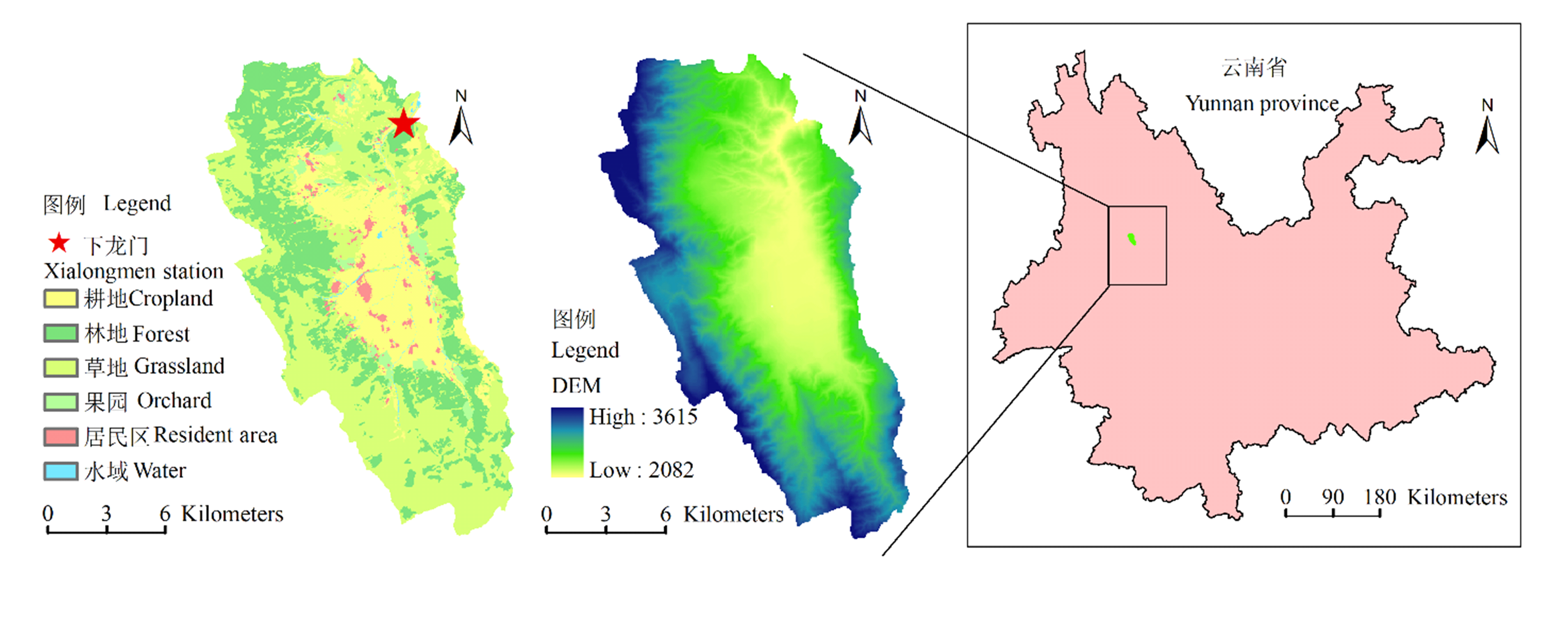
图1
凤羽河流域位置图、数字高程图、土地利用图和流域出口监测点"
表1
空间数据的精度和来源"
| 数据类别 Data item | 数据来源 Data source | 比例尺 Scale | 数据用途 Purpose |
|---|---|---|---|
| 数字高程图 Digital elevation model | 国家基础地理信息中心 National geomatic center of China | 1﹕50000 | 坡度、河网的提取及流域的划分 Extracting slope, river network and watershed division |
| 土地利用数据 Land use data | 大理州洱源县土地局(2003年) Land Resources Bureau | 1﹕10000 | 获得流域内土地利用类型及比例 Land use information |
| 水系图 Drainage map | 国家基础地理信息中心 National geomatic center of China | 1﹕250000 | 获得流域内水系分布情况 Distribution of river systems |
| 土壤图(soil-1) Soil map | 全国第二次土壤普查土壤图 The 2nd national soil survey | 1﹕50000 | 获得土壤类型及分布 Soil type and distribution |
| 土壤图(soil-2) Soil map | 全国第二次土壤普查土壤图 The 2nd national soil survey | 1﹕500000 | 获得土壤类型及分布 Soil type and distribution |
| 土壤图(soil-3) Soil map | 中国科学院南京土壤研究所 Institute of soil science, CAS | 1﹕1000000 | 获得土壤类型及分布 Soil type and distribution |

图2
3种比例尺的土壤图和采样点"
表2
模型所需其他数据及其来源"
| 数据类别 Data item | 数据来源 Data source | 数据用途 Purpose |
|---|---|---|
| 气象数据 Weather data | 气象观测站 Weather station | 降水、气温、太阳辐射、风速等数据 Precipitation, temperature and so on |
| 土壤属性数据 Soil properties data | 土种志,野外挖掘土壤剖面及采样实测 Annals of soil classification, soil profiles and samples | 获得土壤物理及化学属性数据 Soil physical and chemical properties |
| 农田管理措施 Management information | 农户调查、统计资料 Survey and statistical data | 作物种植模式、施肥、灌溉和耕作情况 Field management data |
| 农村生活污染及畜禽养殖 Living pollution and livestock farming | 农户调查、统计资料 Survey and statistical data | 农村污水、固废垃圾产生量及处理方式,畜禽养殖 规模及其粪便处理方式等 Waste water, solid waste and livestock data |
表3
选取的水文循环参数及其初始阈值"
| 参数 Parameter | 参数说明 Parameter description | 初始阈值 Initial threshold | |
|---|---|---|---|
| R_CN2.mgt | 水分条件Ⅱ时的初始SCS径流曲线数 Initial SCS runoff curve number for moisture condition II | -1 | 0.5 |
| V_ALPHA_BF.gw | 基流α因子 Baseflow alpha factor | 0 | 1 |
| V_RCHRG_DP.gw | 深层含水层的渗透系数 Deep aquifer percolation fraction | 0 | 1 |
| V_GW_REVAP.gw | 地下水的revap系数 Groundwater “revap” coefficient | 0.02 | 0.2 |
| V_GW_DELAY.gw | 地下水的时间延迟 Groundwater delay time | 0 | 500 |
| V_GWQMN.gw | 发生回归流的浅层含水层的水位阈值 Threshold depth of water in the shallow aquifer required for return flow to occur | 0 | 5000 |
| V_SHALLST.gw | 浅层含水层的初始水深 Initial depth of water in the shallow aquifer | 0 | 50000 |
| V_DEEPST.gw | 深层含水层的初始水深 Initial depth of water in the deep aquifer | 0 | 50000 |
| V_SLSUBBSN.hru | 平均坡长 Average slope length | 10 | 150 |
| V_OV_N.hru | 坡面漫流的曼宁系数n值 Manning’s “n” value for overland flow | 0.01 | 30 |
| V_ESCO.hru | 土壤蒸发补偿因子 Soil evaporation compensation factor | 0.01 | 1 |
| V_LAT_TTIME.hru | 侧向流的运动时间 Lateral flow travel time | 0 | 180 |
| V_EPCO.hru | 植物吸收补偿因子 Plant uptake compensation factor | 0 | 1 |
| V_HRU_SLP.hru | 平均比降 Average slope steepness | 0 | 1 |
| V_CH_N2.rte | 主河道的曼宁系数n值 Manning’s “n” value for the main channel | -0.01 | 0.3 |
| V_FFCB.bsn | 初始土壤蓄水量 Initial soil water storage | 0 | 1 |
| V_SURLAG.bsn | 地表径流滞后系数 Surface runoff lag coefficient | 0.05 | 24 |
表4
选取的营养物参数及其初始阈值"
| 参数 Parameter | 参数说明 Parameter description | 初始阈值 Initial threshold | |
|---|---|---|---|
| V_BIOMIX.mgt | 生物混合效率 Biological mixing efficiency | 0 | 1 |
| V_FRT_SURFACE.mgt | 表层10 mm土壤中的施肥量占施肥总量的分数 Fraction of fertilizer applied to top 10 mm of soil | 0 | 1 |
| V_FILTERW.mgt | 过滤带宽度 Width of edge-of-field filter strip | 0 | 100 |
| V_GWSOLP.gw | 向子流域河流输入的地下水中可溶性磷浓度 Concentration of soluble phosphorus in groundwater contribution to streamflow from subbasin | 0 | 1000 |
| V_ERORGN.hru | 泥沙运移中有机氮的富集比 Organic N enrichment ratio for loading with sediment | 0 | 5 |
| V_ERORGP.hru | 泥沙运移中有机磷的富集比 Phosphorus enrichment ratio for loading with sediment | 0 | 5 |
| V_CDN.bsn | 反硝化指数速率系数 Denitrification exponential rate coefficient | 0 | 3 |
| V_SDNCO.bsn | 发生反硝化作用的土壤含水量阈值 Denitrification threshold water content | 0 | 1 |
| V_RSDCO.bsn | 残留物的分解系数 Residue decomposition coefficient | 0.02 | 0.1 |
| V_PPERCO.bsn | 磷的渗流系数 Phosphorus percolation coefficient in soil layer | 10 | 17.5 |
| V_PHOSKD.bsn | 磷的土壤分配系数 Phosphorus soil partitioning coefficient | 100 | 200 |
| V_NPERCO.bsn | 硝酸盐的渗流系数 Nitrate percolation coefficient | 0 | 1 |
| V_BC1_BSN.bsn | NH3生物氧化的速率常数 Rate constant for biological oxidation of NH3 | 0.1 | 1 |
| V_BC2_BSN.bsn | 从NO2到NO3的生物氧化速率常数 Rate constant for biological oxidation NO2 to NO3 | 0.1 | 1 |
| V_BC3_BSN.bsn | 从有机氮到氨基的水解速率常数 Rate constant for hydrolysis of organic nitrogen to ammonia | 0.02 | 0.4 |
| V_BC4_BSN.bsn | 从有机磷到可溶性磷的腐化速率常数 Rate constant for decay of organic phosphorus to dissolved phosphorus | 0.01 | 0.7 |
表5
选取的泥沙参数及其初始阈值"
| 参数 Parameter | 参数说明 Parameter description | 初始阈值 Initial threshold | |
|---|---|---|---|
| R_USLE_C.plant.dat | USLE方程中的C因子的最小值 Minimum value of USLE C factor | -10 | 10 |
| V_USLE_P.mgt | USLE方程中的P因子 USLE equation support practice factor | 0 | 1 |
| V_LAT_SED.hru | 侧向流与地下径流中的泥沙含量 Sediment concentration in lateral and groundwater flow | 0 | 5000 |
| V_ADJ_PKR.bsn | 子流域(支流)泥沙演算的最大流速调节因子 Peak rate adjustment factor for sediment routing in the subbasin | 0.5 | 2 |
表6
选取的河道过程参数及其初始阈值"
| 参数 Parameter | 参数说明 Parameter description | 初始阈值 Initial threshold | |
|---|---|---|---|
| V_SPCON.bsn | 最大泥沙量的线性参数 Linear parameter for calculating the maximum amount of sediment | 0.0001 | 0.01 |
| V_SPEXP.bsn | 最大泥沙量的指数参数 Exponent parameter for calculating sediment restrained in channel sediment routing | 1 | 2 |
| V_CH_K2.rte | 主河道冲积物的有效渗透系数 Effective hydraulic conductivity in main channel alluvium | -0.01 | 500 |
| V_CH_COV1.rte | 河道侵蚀因子 Channel erodibility factor | -0.05 | 0.6 |
| V_CH_COV2.rte | 河道覆盖因子 Channel cover factor | -0.001 | 1 |
| V_ALPHA_BNK.rte | 河岸调蓄的基流α因子 Baseflow alpha factor for bank storage | 0 | 1 |
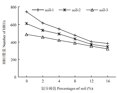
图3
不同土壤数据的阈值设置对HRU划分的影响"
表7
不同土壤数据下的模型参数"
| 土壤数据 Soil data | SCS径流曲线数CN2 | 最大根系深度 SOL_ZMX (mm) | 土层埋深 SOL_Z (mm) | 湿容重 SOL_BD (g·cm-3) | 有效含水量SOL_AWC (mm·mm-1) | 饱和渗透系数SOL_K (mm·h-1) | 土壤侵蚀K因子USLE_K |
|---|---|---|---|---|---|---|---|
| soil-1 | 72.93 | 722.73 | 211.24 | 1.19 | 0.16 | 21.61 | 0.27 |
| soil-2 | 77.43 | 879.93 | 160.66 | 1.15 | 0.36 | 42.56 | 0.29 |
| soil-3 | 66.23 | 526.07 | 201.79 | 1.27 | 0.18 | 21.18 | 0.24 |
表8
校准前后模型的表现效果"
| 土壤数据 Soil data | 项目 Item | 校准后 After calibration | 校准前 Before calibration | ||
|---|---|---|---|---|---|
| R2 | NS | R2 | NS | ||
| soil-1 | 流量Flow | 0.81 | 0.68 | 0.84 | -5.29 |
| 泥沙 Sediment | 0.44 | 0.43 | 0.49 | 0.31 | |
| 总氮Total nitrogen | 0.58 | 0.57 | 0.50 | -605.73 | |
| 总磷Total phosphorus | 0.53 | 0.53 | 0.30 | -5007.4 | |
| soil-2 | 流量Flow | 0.86 | 0.79 | 0.77 | -6.86 |
| 泥沙 Sediment | 0.46 | 0.41 | 0.50 | 0.1 | |
| 总氮Total nitrogen | 0.71 | 0.59 | 0.53 | -710.97 | |
| 总磷Total phosphorus | 0.75 | 0.75 | 0.31 | -1539.57 | |
| soil-3 | 流量Flow | 0.75 | 0.64 | 0.86 | -5.27 |
| 泥沙 Sediment | 0.43 | 0.38 | 0.45 | 0.28 | |
| 总氮Total nitrogen | 0.85 | 0.69 | 0.49 | -1097.61 | |
| 总磷Total phosphorus | 0.63 | 0.62 | 0.29 | -5717.73 | |
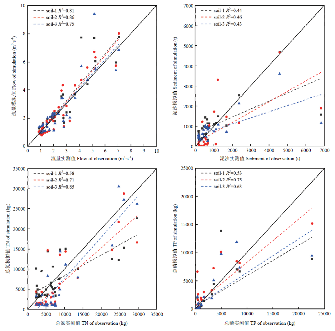
图4
3种精度土壤数据在进行模型校准后的模拟效果"

图5
子流域划分图"
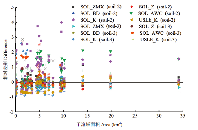
图6
基于不同土壤图获得的土壤参数随子流域面积的变化"
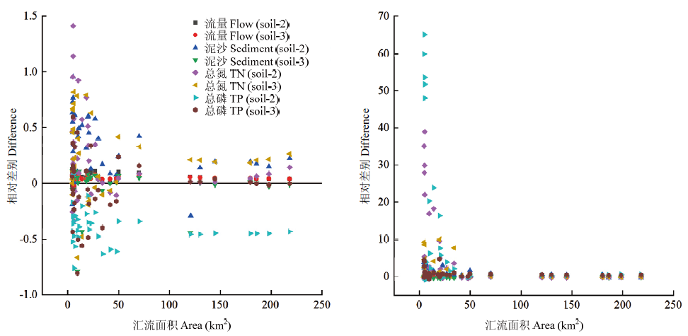
图7
在进行模型校验前(左)后(右)基于不同土壤数据模拟结果的差异与汇流面积的关系"
| [1] | 中华人民共和国生态环境部. 中国环境状况公报. 环保工作资料选, 2017: 17-31. |
| Ministry of Ecology and Environment of the People's Republic of China. Bulletin on the state of China's environment. Environmental Performance Information, 2017: 17-31. (in Chinese) | |
| [2] | 赵永宏, 邓祥征, 战金艳, 席北斗, 鲁奇. 我国湖泊富营养化防治与控制策略研究进展. 环境科学与技术, 2010,33(3):92-98. |
| ZHAO Y H, DENG X Z, ZHAN J Y, XI B D, LU Q. Progress on preventing and controlling strategies of lake eutrophication in China. Environmental Science & Technology, 2010,33(3):92-98. (in Chinese) | |
| [3] | HOWARTH R, CHAN F, CONLEY D J, GARNIER J, DONEY S C, MARINO R, BILLEN G. Coupled biogeochemical cycles: eutrophication and hypoxia in temperate estuaries and coastal marine ecosystems. Frontiers in Ecology & the Environment, 2011,9(1):18-26. |
| [4] |
ROY J W, BICKERTON G. Elevated dissolved phosphorus in riparian groundwater along gaining urban streams. Environmental Science & Technology, 2014,48(3):1492-1498.
pmid: 24422427 |
| [5] | MORSE N B, WOLLHEIM W M. Climate variability masks the impacts of land use change on nutrient export in a suburbanizing watershed. Biogeochemistry, 2014,121(1):45-59. |
| [6] | 陈亮, 董晓华, 李英海, 李中华, 刘冀, 薄会娟, 万浩, 蔡莉莉. 基于SWAT模型的黄柏河东支流域气候变化的水文响应研究. 三峡大学学报(自然科学版), 2019(2):1-5. |
| CHEN L, DONG X H, LI Y H, LI Z H, LIU J, BO H J, WAN H, CAI L L. Hydrological response of climate change in east branch of Huangbaihe river based on SWAT model. Journal of China Three Gorges University(Natural Sciences), 2019(2):1-5. (in Chinese) | |
| [7] | 娄永才, 郭青霞. 岔口小流域非点源污染模型AnnAGNPS不确定性分析. 农业环境科学学报, 2018,37(5):956-964. |
| LOU Y C, GUO Q X. Uncertainty analysis of an AnnAGNPS model used in the Chakou watershed. Journal of Agro-Environment Science, 2018,37(5):956-964. (in Chinese) | |
| [8] | 罗娜, 李华, 樊霆, 郭彬, 李凝玉, 傅庆林, 马洁, 金跃群. HSPF模型在流域面源污染模拟中的应用. 浙江农业科学, 2019(1):141-145. |
| LUO N, LI H, FAN T, GUO B, LI N Y, FU Q L, MA J, JIN Y Q. Application of HSPF model in simulation of non-point source pollution. Journal of Zhejiang Agricultural Sciences, 2019(1):141-145. (in Chinese) | |
| [9] | ZHANG X, HAO F, CHENG H, LI D. Application of swat model in the upstream watershed of the Luohe River. Chinese Geographical Science, 2003,13(4):334-339. |
| [10] | 余红, 沈珍瑶. 非点源污染不确定性研究进展. 水资源保护, 2008,24(1):1-5. |
| YU H, SHEN Z Y. Uncertainty of non-point source pollution. Water Resources Protection, 2008,24(1):1-5. (in Chinese) | |
| [11] | 廖谦, 沈珍瑶. 农业非点源污染模拟不确定性研究进展. 生态学杂志, 2011,30(7):1542-1550. |
| LIAO Q, SHEN Z Y. Uncertainties in agricultural non-point source pollution simulation: Research progress. Chinese Journal of Ecology, 2011,30(7):1542-1550. (in Chinese) | |
| [12] |
LI W, ZHAI L, LEI Q, WOLLHEIM W M, LIU J, LIU H, HU W, REN T, WANG H, LIU S. Influences of agricultural land use composition and distribution on nitrogen export from a subtropical watershed in China. Science of the Total Environment, 2018,642:21-32.
doi: 10.1016/j.scitotenv.2018.06.048 pmid: 29894879 |
| [13] | 崔超. 三峡库区香溪河流域氮磷入库负荷及迁移特征研究[D]. 北京: 中国农业科学院, 2016. |
| CUI C. Characteristics of nitrogen and phosphorus loadings into receiving water body and migration in Xiangxi river basin, Three Gorges Reservoir region[D]. Beijing: Chinese Academy of Agricultural Sciences, 2016. (in Chinese) | |
| [14] | 李润奎, 朱阿兴, 陈腊娇, 刘军志, 宋现锋, 林耀明. SCS-CN模型中土壤参数的作用机制研究. 自然资源学报, 2013,28(10):1778-1787. |
| LI R K, ZHU A X, CHEN L J, LIU J Z, SONG X F, LIN Y M. Effects of soil parameters in SCS-CN runoff model. Journal of Natural Resources, 2013,28(10):1778-1787. (in Chinese) | |
| [15] | DIEK S, TEMME A J A M, TEULING A J. The effect of spatial soil variation on the hydrology of a semi-arid Rocky Mountains catchment. Geoderma, 2014,235-236(4):113-126. |
| [16] | WORQLUL A W, AYANA E K, YEN H, JEONG J, MACALISTER C, TAYLOR R, GERIK T J, STEENHUIS T S. Evaluating hydrologic responses to soil characteristics using SWAT model in a paired- watersheds in the Upper Blue Nile Basin. Catena, 2018,163:332-341. |
| [17] |
CHEN L, WANG G, ZHONG Y, SHEN Z. Evaluating the impacts of soil data on hydrological and nonpoint source pollution prediction. Science of the Total Environment, 2016,563-564:19-28.
doi: 10.1016/j.scitotenv.2009.10.027 pmid: 19896162 |
| [18] | 叶许春, 张奇, 刘健, 李丽娇, 左海军. 土壤数据空间分辨率对水文过程模拟的影响. 地理科学进展, 2009,28(4):575-583. |
| YE X C, ZHANG Q, LIU J, LI L J, ZUO H J. Effects of spatial resolution of soil data on hydrological processes. Modeling Progress in Geography, 2009,28(4):575-583. (in Chinese) | |
| [19] | LI R K, RUI X P, ZHU A X, LIU J Z, Band L E, Song X F. Increasing detail of distributed runoff modeling using fuzzy logic in curve number. Environmental Earth Sciences, 2015,73(7):3197-3205. |
| [20] |
李润奎, 朱阿兴, 李宝林, 裴韬, 秦承志. 流域水文模型对土壤数据响应的多尺度分析. 地理科学进展, 2011,30(1):80-86.
doi: 10.11820/dlkxjz.2011.01.010 |
|
LI R K, ZHU A X, LI B L, PEI T, QIN C Z. Response of simulated stream flow to soil data spatial detail across different routing areas. Progress in Geography, 2011,30(1):80-86. (in Chinese)
doi: 10.11820/dlkxjz.2011.01.010 |
|
| [21] | KUMAR S, MERWADE V. Impact of watershed subdivision and soil data resolution on SWAT model calibration and parameter uncertainty. Jawra Journal of the American Water Resources Association, 2009,45(5):1179-1196. |
| [22] |
MENGISTU G, MCCRAY J E. Effects of soil data resolution on SWAT model stream flow and water quality predictions. Journal of Environmental Management, 2008,88(3):393-406.
doi: 10.1016/j.jenvman.2007.03.016 pmid: 17475392 |
| [23] | WANG X, MELESSE A M. Effects of STATSGO and SSURGO as inputs on SWAT Model's Snowmelt Simulation. Jawra Journal of the American Water Resources Association, 2006,42(5):1217-1236. |
| [24] |
庞燕, 项颂, 储昭升, 薛力强, 叶碧碧. 洱海流域农业用地与入湖河流水质的关系研究. 环境科学, 2015,36(11):4005-4012.
doi: 10.1021/es0200903 |
|
PANG Y, XIANG S, CHU Z S, XUE L Q, YE B B. Relationship between agricultural land and water quality of inflow river in Erhai Lake basin. Environmental Science, 2015,36(11):4005-4012. (in Chinese)
doi: 10.1021/es0200903 |
|
| [25] | 张辰, 陆建忠, 陈晓玲. 基于输出系数模型的云南洱海流域农业非点源污染研究. 华中师范大学学报(自然科学版), 2017,51(1):108-114. |
| ZHANG C, LU J Z, CHEN X L. Study of pollution from agricultural non-point sources in Lake Erhai watershed in Yunnan Province based on export coefficient model. Journal of Central China Normal University (Natural Sciences), 2017,51(1):108-114. (in Chinese) | |
| [26] | 张召喜. 基于SWAT模型的凤羽河流域农业面源污染特征研究[D]. 北京: 中国农业科学院, 2013. |
| ZHANG Z X. Study on charateristics of agricultural non-point source pollution in Fengyu river basin on SWAT model[D]. Beijing: Chinese Academy of Agricultural Sciences, 2013. (in Chinese) | |
| [27] | 李文超. 凤羽河流域农业面源污染负荷估算及关键区识别研究[D]. 北京: 中国农业科学院, 2014. |
| LI W C. Evaluating the loads of agricultural non-point source pollution and identifying critical source areas in Fengyu basin[D]. Beijing: Chinese Academy of Agricultural Sciences, 2014. (in Chinese) | |
| [28] | 龙爱华. SWAT 2009理论基础. 郑州: 黄河水利出版社, 2012. |
| LONG A H. Theoretical Documentation Version 2009 Soil&Water Assessment Tool. Zhengzhou: The Yellow River Water Conservancy Press, 2012. (in Chinese) | |
| [29] | SHARIFI A, LANG M W, MCCARTY G W, SADEGHI A M, LEE S, YEN H, RABENHORST M C, JEONG J, YEO I Y. Improving model prediction reliability through enhanced representation of wetland soil processes and constrained model auto calibration - A paired watershed study. Journal of Hydrology, 2016,541:1088-1103. |
| [30] |
MORIASI D N, ARNOLD J G, LIEW M W V, BINGNER R L, HARMEL R D, VEITH T L. Model evaluation guidelines for systematic quantification of accuracy in watershed simulations. Transactions of the ASABE, 2007,50(3):885-900.
doi: 10.13031/2013.23153 |
| [31] |
GOWDA P H, MULLA D J, NANGIA V, ALE S. Scale effects of STATSGO and SSURGO on flow and water quality predictions. Journal of Water Resource and Protection, 2013,5(3):266-274.
doi: 10.4236/jwarp.2013.53027 |
| [32] |
CHAPLOT V. Impact of DEM mesh size and soil map scale on SWAT runoff, sediment, and NO3--N loads predictions. Journal of Hydrology, 2005,312(1/4):207-222.
doi: 10.1016/j.jhydrol.2005.02.017 |
| [33] | BARONI G, ZINK M, KUMAR R, SAMANIEGO L, ATTINGER S. Effects of uncertainty in soil properties on simulated hydrological states and fluxes at different spatio-temporal scales. Hydrology & Earth System Sciences, 2017,21(5):1-37. |
| [34] |
LI R, ZHU A, SONG X, LI B, PEI T, QIN C. Effects of Spatial Aggregation of Soil Spatial Information on Watershed Hydrological Modeling. Hydrological Processes, 2012,26:1390-1404.
doi: 10.1002/hyp.v26.9 |
| [35] | 李润奎, 朱阿兴, 秦承志, 陈腊娇, 刘军志. 土壤数据对分布式流域水文模型模拟效果的影响. 水科学进展, 2011,22(2):168-174. |
| LI R K, ZHU A X, QIN C Z, CHEN L J, LIU J Z. Effects of spatial detail of soil data on distributed hydrological modeling. Advances in Water Science, 2011,22(2):168-174. (in Chinese) | |
| [36] |
朱阿兴, 杨琳, 樊乃卿, 曾灿英, 张甘霖. 数字土壤制图研究综述与展望. 地理科学进展, 2018,37(1):66-78.
doi: 10.18306/dlkxjz.2018.01.008 |
|
ZHU A X, YANG L, FAN N Q, ZENG C Y, ZHANG G L. The review and outlook of digital soil mapping. Progress in Geography, 2018,37(1):66-78. (in Chinese)
doi: 10.18306/dlkxjz.2018.01.008 |
|
| [37] | BOSSA A Y, DIEKKRUGER B, IGUE A M, GAISER T. Analyzing the effects of different soil databases on modeling of hydrological processes and sediment yield in Benin (West Africa). Geoderma, 2012, 173-174(2):61-74. |
| [38] | 李润奎, 朱阿兴, Peter C. Augello, James E. Burt. SWAT模型对高精度土壤信息的敏感性研究. 地球信息科学学报, 2007,9(3):72-78. |
| LI R K, ZHU A X, PETER C A, JAMES E B. Sensitivity of SWAT model to detailed soil information. Geo-Information Science, 2007,9(3):72-78. (in Chinese) | |
| [39] |
WAHREN F T, JULICH S, NUNES J P, GONZALEZ P O, HAWTREE D, FEGER K H, KEIZER J J. Combining digital soil mapping and hydrological modeling in a data scarce watershed in north-central Portugal. Geoderma, 2016,264:350-362.
doi: 10.1016/j.geoderma.2015.08.023 |
| [40] | ZIADAT F M, DHANESH Y, SHOEMATE D, SRINIVASAN R, NARASIMHAN B, TECH J. Soil-Landscape Estimation and Evaluation Program (SLEEP) to predict spatial distribution of soil attributes for environmental modeling. International Journal of Agricultural & Biological Engineering, 2015,8(3):1-15. |
| [1] | 张峭, 王克. 农业生产风险评估及农业保险费率厘定的不确定性:研究进展和破解之道[J]. 中国农业科学, 2021, 54(22): 4778-4786. |
| [2] | 张亦涛,王洪媛,刘宏斌,任天志. 基于大型渗漏池监测的褐潮土农田水、氮淋失特征[J]. 中国农业科学, 2016, 49(1): 110-119. |
| [3] | 刘海涛,胡克林,李保国,任图生. 土壤剖面基础性质差异对农田水氮过程和作物产量的影响[J]. 中国农业科学, 2015, 48(7): 1348-1360. |
| [4] | 郭小红,王兴才,孟田,张惠君,敖雪,王海英,谢甫绨. 中美大豆Ⅲ熟期组代表品种根系形态和活力的比较研究[J]. 中国农业科学, 2015, 48(19): 3821-3833. |
| [5] | 竞霞1, 2, 魏曼3, 王纪华1, 宋晓宇1, 胡荣明2. 基于边界域修正粗糙熵模型的遥感影像分类不确定性评价[J]. 中国农业科学, 2014, 47(11): 2135-2141. |
| [6] | 吕尊富, 刘小军, 汤亮, 刘蕾蕾, 曹卫星, 朱艳. 基于WheatGrow和CERES模型的区域小麦生育期预测与评价[J]. 中国农业科学, 2013, 46(6): 1136-1148. |
| [7] | 张微微, 李红, 孙丹峰, 周连第. 密云水库上游白河磷浓度时间序列的傅立叶与小波分析[J]. 中国农业科学, 2011, 44(10): 2060-2069. |
| [8] | 李玉全,李 健,王清印,张海艳. 密度胁迫对凡纳滨对虾生长及非特异性免疫因子的影响[J]. 中国农业科学, 2007, 40(9): 2091-2096 . |
| [9] | 刘 方,罗海波,刘元生,刘鸿雁,何腾兵,龙 健. 喀斯特石漠化区农业土地利用对浅层地下水质量的影响[J]. 中国农业科学, 2007, 40(6): 1214-1221 . |
|
||