


中国农业科学 ›› 2019, Vol. 52 ›› Issue (2): 273-284.doi: 10.3864/j.issn.0578-1752.2019.02.007
邱孟龙1,曹小曙1,周建1,冯小龙2,高兴川1
收稿日期:2018-05-29
接受日期:2018-09-28
出版日期:2019-01-16
发布日期:2019-01-21
联系方式:
邱孟龙,Tel:029-85310659;E-mail: qml7886@163.com
基金资助:QIU MengLong1,CAO XiaoShu1,ZHOU Jian1,FENG XiaoLong2,GAO XingChuan1
Received:2018-05-29
Accepted:2018-09-28
Published:2019-01-16
Online:2019-01-21
摘要: 【目的】 通过探究渭北黄土旱塬区粮食单产在县域尺度上的空间分异特征及其影响因子,为小尺度粮食单产及其影响因子的空间分异研究、区域粮食单产提高提供科学依据。【方法】 应用空间自相关、最小二乘法和地理加权回归模型(GWR),研究渭北黄土旱塬区典型粮食主产县陕西彬县粮食单产的空间分布特征及其影响因子的空间分异。【结果】 彬县粮食单产的Moran’s I指数为0.328,显著性检验的Z值为5.51,呈北高南低的局部空间集聚特征。坡度、耕层厚度、土壤有机质、道路密度和施肥成本对彬县粮食单产具有正向影响,土壤类型、侵蚀程度和地下水埋深对彬县粮食单产具有负向影响,各解释变量回归系数的相对极差范围为0.55—14.11。空间上,耕层厚度、土壤类型、侵蚀程度、土壤有机质和道路密度对彬县南部、东南部梁峁丘陵沟壑区粮食单产的影响强于北部黄土旱塬区,而坡度、地下水埋深和施肥成本则表现出相反的空间非平稳性特征。OLS模型回归系数的显著性与GWR模型回归系数的相对极差呈负相关关系。GWR模型的R 2比OLS模型提高了0.04,AIC值减少了11.04。 【结论】 彬县粮食单产之间存在显著的空间正相关关系;土壤有机质、施肥成本和地下水埋深是渭北黄土旱塬区县域粮食单产的最主要影响因子;同一影响因子在县域内的不同空间位置对粮食单产的影响程度存在较大差异,且各影响因子对粮食单产影响程度的空间非平稳性是导致OLS模型回归系数显著性水平较低的主要原因。GWR模型在空间非平稳性数据建模方面的解释能力与估计精度都优于OLS模型,且能够实现模型估计参数的空间可视化。
邱孟龙,曹小曙,周建,冯小龙,高兴川. 基于GWR模型的渭北黄土旱塬粮食单产空间分异 及其影响因子分析——以陕西彬县为例[J]. 中国农业科学, 2019, 52(2): 273-284.
QIU MengLong,CAO XiaoShu,ZHOU Jian,FENG XiaoLong,GAO XingChuan. Spatial Differentiation and Impact Factors of Grain Yield Per Hectare in Weibei Plateau Based on GWR Model: A Case Study of Binxian County, Shannxi[J]. Scientia Agricultura Sinica, 2019, 52(2): 273-284.
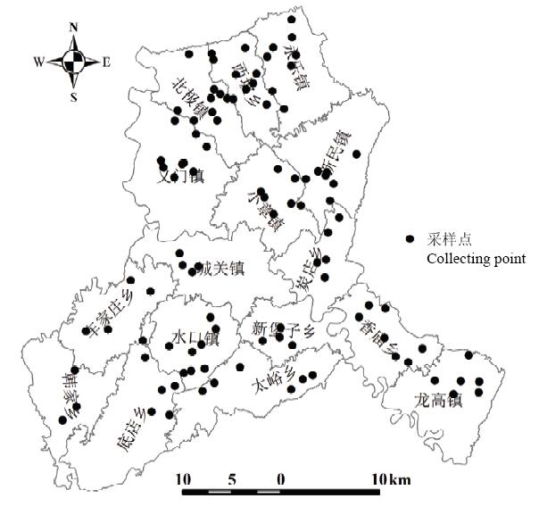
图1
数据采集样点空间分布图"
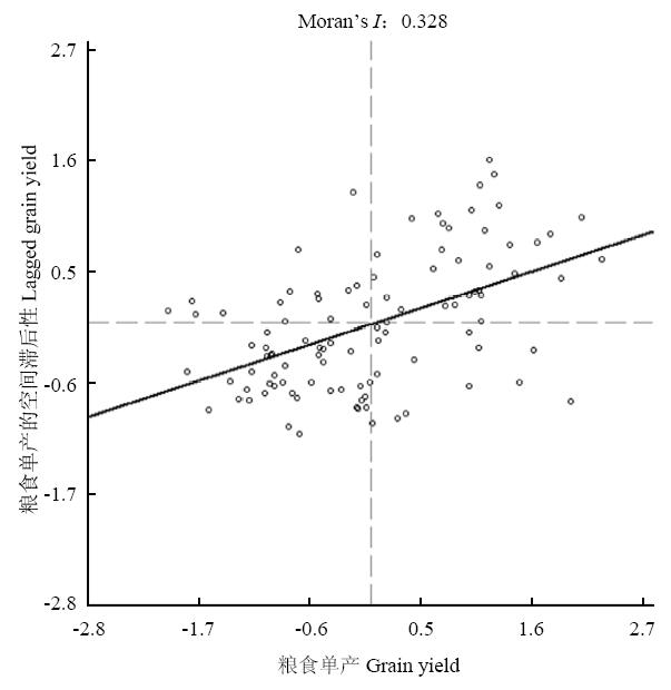
图2
彬县粮食单产Moran’s I散点图"
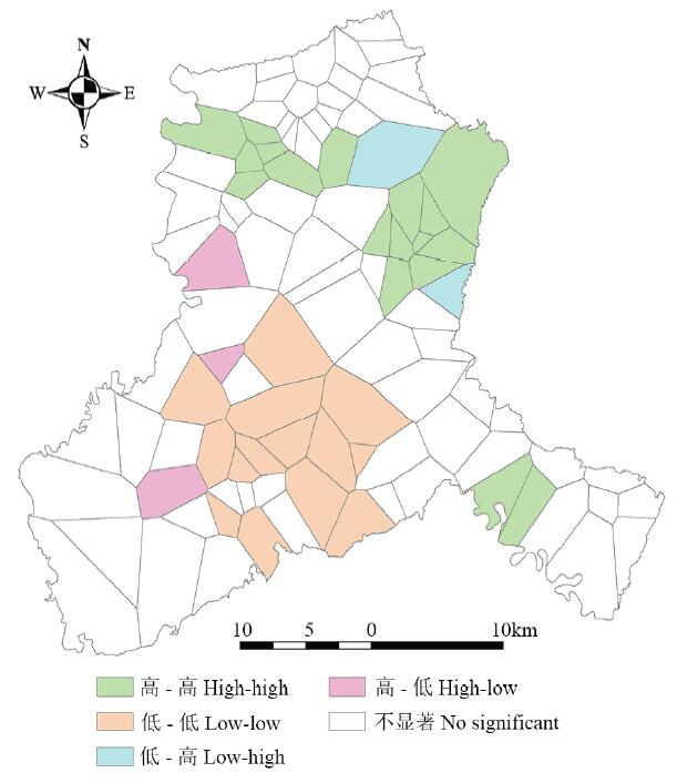
图3
彬县粮食单产的LISA集聚图"
表1
OLS模型回归估计结果"
| 变量 Variable | 非标准化系数 Unstandardized coefficients | 标准误差 Standard error | 标准化系数 Standardization coefficient | t值 t value | P值 P value |
|---|---|---|---|---|---|
| 常数项 Intercept | 288.55 | 31.11 | --- | 9.28 | 0.00 |
| 坡度 Slope | 16.81 | 26.87 | 0.04 | 0.63 | 0.53 |
| 耕层厚度 Plough layer thickness | 45.95 | 32.57 | 0.10 | 1.41 | 0.16 |
| 土壤类型 Soil type | -37.13 | 23.88 | -0.08 | -1.95 | 0.09 |
| 侵蚀程度 Erosion degree | -26.84 | 22.74 | -0.07 | -1.18 | 0.24 |
| 土壤有机质 Soil organic matter | 218.80 | 32.83 | 0.45 | 6.66 | 0.00 |
| 地下水埋深 Groundwater depth | -87.97 | 17.81 | -0.28 | -4.94 | 0.00 |
| 道路密度 Road density | 35.05 | 22.57 | 0.09 | 1.95 | 0.09 |
| 施肥成本 Cost of fertilization | 178.33 | 22.61 | 0.42 | 7.89 | 0.00 |
表2
GWR模型回归参数统计"
| 参数 Parameters | 平均值 Mean | 最小值 Minimum | 最大值 Maximum | 上四分位值 Upper quartile | 下四分位值 Lower quartile | 中位数 Median | 相对极差 Relative ranges |
|---|---|---|---|---|---|---|---|
| 常数项 Intercept | 297.57 | 246.90 | 329.88 | 286.52 | 314.55 | 299.85 | 0.28 |
| 坡度 Slope | 5.18 | -45.30 | 27.81 | -9.53 | 22.16 | 11.83 | 14.11 |
| 耕层厚度 Plough layer thickness | 42.30 | 33.35 | 66.25 | 37.63 | 45.30 | 42.05 | 0.78 |
| 土壤类型 Soil type | -35.94 | -100.74 | 6.57 | -51.11 | -20.31 | -33.44 | 2.99 |
| 侵蚀程度 Erosion degree | -24.85 | -46.13 | 7.77 | -38.97 | -13.68 | -25.11 | 2.17 |
| 土壤有机质 Soil organic matter | 225.50 | 172.00 | 311.23 | 189.92 | 254.17 | 220.21 | 0.62 |
| 地下水埋深 Groundwater depth | -82.94 | -116.71 | -60.55 | -98.08 | -69.51 | -79.40 | 0.68 |
| 道路密度 Road density | 28.28 | -18.36 | 70.14 | 11.46 | 48.93 | 25.63 | 3.13 |
| 施肥成本 Cost of fertilization | 168.07 | 93.21 | 185.42 | 162.60 | 178.68 | 175.91 | 0.55 |
| 粮食单产实测值 Crop yield per unit (kg·hm-2) | 3257.88 | 1775.00 | 4950.00 | 2653.12 | 3893.75 | 3198.75 | 0.97 |
| 粮食单产预测值 Estimating crop yield per unit (kg·hm-2) | 3254.35 | 1888.21 | 5139.93 | 2773.27 | 3680.76 | 3246.47 | 1.00 |
| 条件数 Cond | 22.10 | 19.64 | 29.73 | 20.74 | 23.02 | 21.78 | 0.46 |
| Local R2 | 0.81 | 0.73 | 0.89 | 0.78 | 0.83 | 0.81 | 0.20 |
| 残差 Residual | 3.53 | -769.77 | 576.19 | -172.61 | 160.68 | 19.67 | 381.29 |
表3
OLS模型与GWR模型参数估计比较"
| 模型 Model | 信息准则 AIC | R2 | 调整后的R2 Adjust R2 | 残差平方和 RRS | 残差估计标准差 Sigma |
|---|---|---|---|---|---|
| OLS模型 OLS model | 1080.07 | 0.80 | 0.78 | 198694.52 | 46.22 |
| GWR模型 GWR model | 1069.03 | 0.86 | 0.82 | 140028.34 | 41.53 |
| GWR模型对模拟精度指标的提高 Improvement of simulation accuracy by GWR model | 11.04 | 0.06 | 0.04 | 58666.18 | 4.69 |
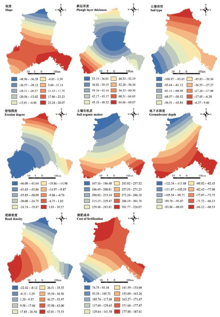
图4
基于GWR模型的彬县粮食单产影响因子回归系数空间分布"
| [1] | 姚成胜, 邱雨菲, 黄琳, 李政通 . 中国城市化与粮食安全耦合关系辨析及其实证分析. 中国软科学,2016(8):75-88. |
| YAO C C, QIU Y F, HUANG L, LI Z T . Coupling relationship between urbanization and food security in China: an empirical study.China Soft Science,2016(8):75-88. (in Chinese) | |
| [2] | 刘玉, 唐秀美, 潘瑜春, 唐林楠 . 黄淮海地区县域粮食单产的空间溢出效应及影响因素分析. 农业工程学报,2016(9):299-307. |
| LIU Y, TANG X M, PAN Y C, TANG L N . Analysis on spatial spillover effect and influence factors of grain yield per hectare at county level in Huang-Huai-Hai region.Transactions of the Chinese Society of Agricultural Engineering,2016(9):299-307. (in Chinese) | |
| [3] |
PATRIGNANI A, LOLLATO R P, OCHSNER T E, GODSEY C B, EDWARDS J T . Yield gap and production gap of rainfed winter wheat in the Southern Great Plains. Agronomy Journal, 2014,106(4):1329-1339.
doi: 10.2134/agronj14.0011 |
| [4] | 程科, 曹裕, 王学春, 李军 . 陕西渭北旱塬粮畜产业区域布局与发展战略. 中国农业资源与区划,2013(4):100-106. |
| CHENG K, CAO Y, WANG X C, LI J . Regional planning and development strategy of grain and livestock industry in Weibei Highland of Shannxi Province.Chinese Journal of Agricultural Resources and Regional Planning,2013(4):100-106. (in Chinese) | |
| [5] | 石玉琼, 李团胜 . 陕西关中耕地粮食生产潜力研究. 中国农学通报,2015(13):196-204. |
| SHI Y Q, LI T S . Farmland grain potential productivity of Guanzhong, Shaanxi Province.Chinese Agricultural Science Bulletin,2015(13):196-204. (in Chinese) | |
| [6] |
HABTEMARIAM L T, KASSA G A, GANDORFER M . Impact of climate change on farms in smallholder farming systems: yield impacts, economic implications and distributional effects. Agricultural Systems, 2017,152:58-66.
doi: 10.1016/j.agsy.2016.12.006 |
| [7] |
BAI H, TAO F, XIAO D, LIU F, ZHANG H . Attribution of yield change for rice-wheat rotation system in China to climate change, cultivars and agronomic management in the past three decades. Climatic Change, 2016,135(3/4):539-553.
doi: 10.1007/s10584-015-1579-8 |
| [8] |
LIPIEC J, USOWICZ B . Spatial relationships among cereal yields and selected soil physical and chemical properties. Science of the Total Environment, 2018,633:1579-1590.
doi: 10.1016/j.scitotenv.2018.03.277 |
| [9] | 贺丽燕, 杜昊辉, 王旭东 . 渭北高原典型黑垆土区土壤物理性状特征及其对小麦产量的影响. 应用生态学报, 2018,29(6):1911-1918. DOI: 10.13287/j.1001-9332.201806.022. |
| HE L Y, DU H H, WANG X D . Soil physical properties and its effects on wheat yield in typical dark loessial soil on Weibei Platea, China. Chinese Journal of Applied Ecology, 2018,29(6):1911-1918. DOI: 10.13287/j.1001-9332.201806.022. (in Chinese) | |
| [10] | MUELLER N D, GERBER J S, JOHNSTON M, RAY D K, RAMANKUTTY N, FOLEY J A . Closing yield gaps through nutrient and water management. Nature, 2013,494(7437):254-257. |
| [11] | MANNA M C, SWARUP A, WANJARI R H, MISHRA B, SHAHI D K . Long-term fertilization, manure and liming effects on soil organic matter and crop yields. Soil & Tillage Research, 2007,94(2):397-409. |
| [12] | 房丽萍, 孟军 . 化肥施用对中国粮食产量的贡献率分析——基于主成分回归C-D生产函数模型的实证研究. 中国农学通报,2013(17):156-160. |
| FANG L P, MENG J . Application of chemical fertilizer on grain yield in China analysis of contribution rate: based on principal component regression C-D production function model and its empirical study.Chinese Agricultural Science Bulletin,2013(17):156-160. (in Chinese) | |
| [13] |
FOSTER T, BROZOVIĆ N, SPEIR C . The buffer value of groundwater when well yield is limited. Journal of Hydrology, 2017,547:638-649.
doi: 10.1016/j.jhydrol.2017.02.034 |
| [14] |
DAVIS K F, RULLI M C, GARRASSINO F, CHIARELLI D, SEVESO A, D'ODORICO P , Water limits to closing yield gaps. Advances in Water Resources, 2017,99:67-75.
doi: 10.1016/j.advwatres.2016.11.015 |
| [15] | 李超, 刘文兆, 林文, 韩晓阳, 周玲, 王亚萍 . 黄土塬区冬小麦产量及水分利用效率对播前底墒变化与生育期差别供水的响应. 中国农业科学, 2017,50(18):3549-3560. |
| LI C, LIU W Z, LIN W, HAN X Y, ZHOU L, WANG Y P . Grain yield and WUE responses to different soil water storage before sowing and water supplies during growing period for winter wheat in the Loess Tableland. Scientia Agricultura Sinica, 2017,50(18):3549-3560. (in Chinese) | |
| [16] | 李靖, 孙晓明 . 省域粮食单产水平与波动状况研究. 中国人口·资源与环境,2011(4):76-80. |
| LI J, SUN X M . Analysis on provincial grain unit yield and its fluctuation conditions.China Population, Resources and Environment,2011(4):76-80. (in Chinese) | |
| [17] | 徐国鑫, 金晓斌, 宋佳楠, 周寅康 . 耕地集约利用对粮食产量变化影响的定量分析——以江苏省为例. 地理研究,2012(9):1621-1630. |
| XU G X, JIN X B, SONG J N, ZHOU Y K . The impact of intensive use of agricultural land on grain yields: a case study of Jiangsu Province.Geographical Research,2012(9):1621-1630. (in Chinese) | |
| [18] | 杨丽霞 . 基于C-D函数和岭回归的粮食生产影响因素分析——以浙江省为例. 地域研究与开发,2013(1):147-151. |
| YANG L X . Grain yield factor analysis based on C-D function and ridge regression: a case study of Zhejiang Province.Areal Research and Development,2013(1):147-151. (in Chinese) | |
| [19] | 张贞, 马赛, 汪权方 . 基于Pearson灰色关联熵的粮食产量主影响因子识别——以河南省为例. 干旱区资源与环境,2017(9):43-48. |
| ZHANG Z, MA S, WANG Q F . Identification of main driving factors influencing the grain production in Henan Province.Journal of Arid Land Resources and Environment,2017(9):43-48. (in Chinese) | |
| [20] | 刘忠, 黄峰, 李保国 . 基于经验模态分解的中国粮食单产波动特征及影响因素. 农业工程学报,2015(2):7-13. |
| LIU Z, HUANG F, LI B G . Analysis on characteristics and influential factors of grain yield fluctuation in China based on empirical mode decomposition.Transactions of the Chinese Society of Agricultural Engineering,2015(2):7-13. (in Chinese) | |
| [21] | 顾乐民 . 基于最小一乘准则的中国粮食产量与影响因素的相关性分析. 农业工程学报,2013(11):1-10. |
| GU L M . Relative analysis of China’s grain yield and influence factors based on criterion of least absolute deviation.Transactions of the Chinese Society of Agricultural Engineering,2013(11):1-10. (in Chinese) | |
| [22] |
MANN M L, WARNER J M . Ethiopian wheat yield and yield gap estimation: a spatially explicit small area integrated data approach. Field Crops Research, 2017,201:60-74.
doi: 10.1016/j.fcr.2016.10.014 |
| [23] | 邓宗兵, 封永刚, 张俊亮, 王炬 . 中国粮食生产空间布局变迁的特征分析. 经济地理,2013(5):117-123. |
| DENG Z B, FENG Y G, ZHANG J L, WANG J . Analysis on the characteristics and tendency of grain production’s spatial distribution in China.Economic Geography,2013(5):117-123. (in Chinese) | |
| [24] | 刘玉, 郭丽英, 刘彦随 . 1980 —2008年环渤海地区县域粮食的时空动态变化及分析. 农业工程学报,2012(12):230-236. |
| LIU Y, GUO L Y , LIU Y S. Spatial-temporal dynamic change and analysis of grain production in county scale in Bohai Rim from 1980 to 2008. Transactions of the Chinese Society of Agricultural Engineering,2012(12):230-236. (in Chinese) | |
| [25] | 卢李朋, 张杰, 姜朋辉, 张胜武 . 甘肃省粮食产量变化的驱动分析及趋势预测. 经济地理,2013(4):125-131. |
| LU L P, ZHANG J, JIANG P H, ZHANG S W . Driven analysis and trend forecasting changes in grain production in Gansu Province.Economic Geography,2013(4):125-131. (in Chinese) | |
| [26] | 任国平, 刘黎明, 付永虎, 袁承程 . 基于GWR模型的都市城郊村域农户生计资本空间差异分析——以上海市青浦区为例. 资源科学,2016(8):1594-1608. |
| REN G P, LIU L M, FU Y H, YUAN C C . Spatial differentiation of rural household livelihood capital in metropolitan suburbs based on GWR model: a case study of Qingpu District in Shanghai. Resources Science,2016(8):1594-1608. (in Chinese) | |
| [27] | 伍育鹏, 郧文聚, 邹如 . 耕地产能核算模型的研究. 农业工程学报,2008(增刊2):108-113. |
| WU Y P, YUN W J, ZOU R . Model for calculation of cultivated land productivity.Transactions of the Chinese Society of Agricultural Engineering,2008(Suppl.2):108-113. (in Chinese) | |
| [28] | 熊昌盛, 谭荣, 岳文泽 . 基于局部空间自相关的高标准基本农田建设分区. 农业工程学报,2015(22):276-284. |
| XIONG C S, TAN R, YUE W Z . Zoning of high standard farmland construction based on local indicators of spatial association.Transactions of the Chinese Society of Agricultural Engineering,2015(22):276-284. (in Chinese) | |
| [29] | 袁玉芸, 瓦哈甫·哈力克, 关靖云, 卢龙辉, 张琴琴 . 基于GWR模型的于田绿洲土壤表层盐分空间分异及其影响因子. 应用生态学报,2016(10):3273-3282. |
| YUAN Y Y, WAHAPU H L K, GUAN J Y, LU L H, ZHANG Q Q, . Spatial differentiation and impact factors of Yutian Oasis’s soil surface salt based on GWR Model.Chinese Journal of Applied Ecology,2016(10):3273-3282. (in Chinese) | |
| [30] | BRUNSDON C, FOTHERINGHAM A S, CHARLTON M E . Geographically weighted regression: a method for exploring spatial nonstationarity. Geographical Analysis, 1996,28(4):281-298. |
| [31] | 魏猛, 张爱君, 诸葛玉平, 李洪民, 唐忠厚, 陈晓光 . 长期不同施肥对黄潮土区冬小麦产量及土壤养分的影响. 植物营养与肥料学报, 2017,23(2):304-312. |
| WEI M, ZHANG A J, ZHUGE Y P, LI H M, TANG Z H, CHEN X G . Effect of different long-term fertilization on winter wheat yield and soil nutrient contents in yellow fluvo-aquic soil area. Journal of Plant Nutrition and Fertilizer, 2017,23(2):304-312. (in Chinese) | |
| [32] | 高洪军, 彭畅, 张秀芝, 李强, 朱平 . 长期不同施肥对东北黑土区玉米产量稳定性的影响. 中国农业科学, 2015,48(23):4790-4799. |
| GAO H J, PENG C, ZHANG X Z, LI Q, ZHU P . Effect of long-term different fertilization on maize yield stability in the Northeast black soil region. Scientia Agricultura Sinica, 2015,48(23):4790-4799. (in Chinese) | |
| [33] | 马小龙, 佘旭, 王朝辉, 曹寒冰, 何红霞, 何刚, 王森, 黄明, 刘璐 . 旱地小麦产量差异与栽培、施肥及主要土壤肥力因素的关系. 中国农业科学, 2016,49(24):4757-4771. |
| MA X L, SHE X, WANG C H, CAO H B, HE H X, HE G, WANG S, HUANG M, LIU L . Yield variation of winter wheat and its relation to cultivation, fertilization, and main soil fertility factors. Scientia Agricultura Sinica, 2016,49(24):4757-4771. (in Chinese) | |
| [34] | LIU Q, CHEN Y, LIU Y, WEN X, LIAO Y . Coupling effects of plastic film mulching and urea types on water use efficiency and grain yield of maize in the Loess Plateau, China. Soil & Tillage Research, 2016,157:1-10. |
| [35] | 肖俊夫, 南纪琴, 刘战东, 俞建河 . 不同地下水埋深夏玉米产量及产量构成关系研究. 干旱地区农业研究,2010(6):36-39. |
| XIAO J F, NAN J Q, LIU Z D, YU J H . Study on yield and yield components of summer maize under different groundwater levels.Agricultural Research in the Arid Areas,2010(6):36-39. (in Chinese) | |
| [36] | 陈秧分, 李先德 . 中国粮食产量变化的时空格局与影响因素. 农业工程学报, 2013,29(20):1-10. |
| CHEN Y F, LI X D . Spatial-temporal characteristics and influencing factors of grain yield change in China. Transactions of the Chinese Society of Agricultural Engineering, 2013,29(20):1-10. (in Chinese) | |
| [37] | 许妍, 吴克宁, 程先军, 刘霈珈 . 东北地区耕地产能空间分异规律及产能提升主导因子分析. 资源科学,2011(11):2030-2040. |
| XU Y, WU K N, CHENG X J, LIU P J . Spatial variation in cultivated land production capacity and analysis of main impact factors for promoting production capacity in Northeast China.Resources Science,2011(11):2030-2040. (in Chinese) | |
| [38] | 宋小青, 欧阳竹 . 1999-2007年中国粮食安全的关键影响因素. 地理学报,2012(6):793-803. |
| SONG X Q SONG X Z . Key influencing factors of food security guarantee in China during 1999-2007. Acta Geographica Sinica,2012(6):793-803. (in Chinese) | |
| [39] | 刘玉, 高秉博, 潘瑜春, 任旭红 . 基于LMDI模型的黄淮海地区县域粮食生产影响因素分解. 农业工程学报, 2013,29(21):1-10. |
| LIU Y, GAO B B, PAN Y C, REN X H . Influencing factor decomposition of grain production at county level in Huang-Huai-Hai region based on LMDI. Transactions of the Chinese Society of Agricultural Engineering, 2013,29(21):1-10. (in Chinese) | |
| [40] | 张红富, 周生路, 吴绍华, 郑光辉, 花盛, 李莉 . 江苏省粮食生产时空变化及影响因素分析. 自然资源学报,2011(2):319-327. |
| ZHANG H F, ZHOU S L, WU S H, ZHENG G H, HUA S, LI L . Temporal and spatial variation of grain production in Jiangsu Province and its influencing factors.Journal of Natural Resources,2011(2):319-327. (in Chinese) | |
| [41] | 黎红梅, 李波, 唐启源 . 南方地区玉米产量的影响因素分析——基于湖南省农户的调查. 中国农村经济,2010(7):87-93. |
| LI H M, LI B, TANG Q Y . Analysis of factors affecting maize yield in southern China-based on the survey of farmers in Hunan.Chinese Rural Economy,2010(7):87-93. (in Chinese) | |
| [42] | 欧阳浩, 戎陆庆, 黄镇谨, 陈波, 王萌 . 基于粗糙集方法的广东省粮食产量影响因素分析. 中国农业资源与区划,2014(6):100-107. |
| OUYANG H, RONG L Q, HUANG Z J, CHEN B, WANG M . Analysis of influencing factors of grain yields in Guangdong Province based on rough set theory.Chinese Journal of Agricultural Resources and Regional Planning,2014(6):100-107. (in Chinese) | |
| [43] | 谢晓彤, 朱嘉伟 . 耕地质量影响因素区域差异分析及提升途径研究——以河南省新郑市为例. 中国土地科学,2017(6):70-78. |
| XIE X T, ZHU J W . The analysis on regional differences of the factors affecting cultivated land quality and the improvement paths: a case study of Xinzheng County, Henan Province.China Land Sciences,2017(6):70-78. (in Chinese) |
| [1] | 刘锴,何闪闪,张彩霞,张利义,卞书迅,袁高鹏,李武兴,康立群,丛佩华,韩晓蕾. 苹果叶片不定芽再生过程的差异表达基因鉴定与分析[J]. 中国农业科学, 2021, 54(16): 3488-3501. |
| [2] | 孙丽娟,胡学旭,陆伟,王步军. 基于GIS的小麦籽粒品质空间分布特征和影响因子分析[J]. 中国农业科学, 2018, 51(5): 999-1011. |
| [3] | 王建林,钟志明,冯西博,付刚,侯维海,王改花,大次卓嘎. 青藏高原青稞蛋白质含量空间分异规律及其与环境因子的关系[J]. 中国农业科学, 2017, 50(6): 969-977. |
| [4] | 李雨,韩平,任东,罗娜,王纪华. 基于地理探测器的农田土壤重金属影响因子分析[J]. 中国农业科学, 2017, 50(21): 4138-4148. |
| [5] | 黄明, 王璐莎. 动物蛋白源抗氧化肽的研究进展[J]. 中国农业科学, 2013, 46(22): 4763-4773. |
| [6] | 庞夙,李廷轩,王永东,余海英,郭其灵,陈东明 . 县域农田土壤铜、锌、铬含量空间变异特征及其影响因子分析[J]. 中国农业科学, 2010, 43(4): 737-743 . |
| [7] | . 典型生态区保护性耕作主体模式及影响农户采用的因子分析[J]. 中国农业科学, 2009, 42(2): 469-477 . |
| [8] | 焦 健,高庆荣,王大伟,郝媛媛,邱新民,姜 辉,郭凤芝. 不同小麦雄性不育类型光合速率的影响因子分析[J]. 中国农业科学, 2008, 41(6): 1622-1629 . |
| [9] | 白耀宇,蒋明星,程家安. 影响Bt稻离体叶中Cry1Ab杀虫蛋白降解的环境因子研究[J]. 中国农业科学, 2006, 39(04): 721-727 . |
| [10] | 马立锋,韩文炎,石元值,阮建云. 浙江省部分茶区茶园土壤中硼含量及影响因素研究[J]. 中国农业科学, 2003, 36(12): 1515-1518 . |
|
||