基于Sentinel卫星及无人机多光谱的滨海冬小麦种植区土壤盐分反演研究——以黄三角垦利区为例
奚雪1( ),赵庚星1(),高鹏1,崔昆1,李涛2
),赵庚星1(),高鹏1,崔昆1,李涛2
Inversion of Soil Salinity in Coastal Winter Wheat Growing Area Based on Sentinel Satellite and Unmanned Aerial Vehicle Multi-Spectrum— A Case Study in Kenli District of the Yellow River Delta
XI Xue1(),ZHAO GengXing1(),GAO Peng1,CUI Kun1,LI Tao2
),ZHAO GengXing1(),GAO Peng1,CUI Kun1,LI Tao2
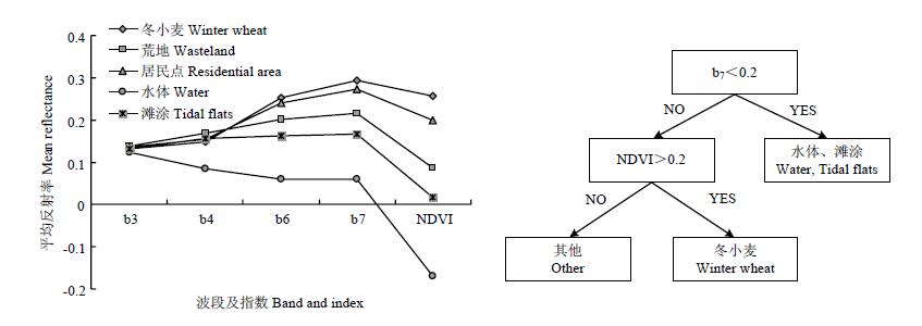
图3. 研究区典型地物光谱曲线(左)及冬小麦决策树提取模型(右)
Fig. 3. Spectral curve of typical features in the study area (left) and extraction model of winter wheat decision tree (right)